Copán
| Maya Site of Copan* | |
|---|---|
| UNESCO World Heritage Site | |
 |
|
| State Party | |
| Type | Cultural |
| Criteria | iv, vi |
| Reference | 129 |
| Region** | Latin America and the Caribbean |
| Inscription history | |
| Inscription | 1980 (4th Session) |
| * Name as inscribed on World Heritage List. ** Region as classified by UNESCO. |
|
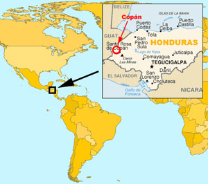
The Pre-Columbian city today known as Copán is a locale in extreme western Honduras, in the Copán Department, near to the Guatemalan border. It is the site of a major Maya kingdom of the Classic era (5th through 9th Centuries).
The kingdom, anciently named Xukpi (Corner-Bundle), flourished from the 5th century AD to the early 9th century, with antecedents going back to at least the 2nd century AD. Its name is an apparent reference to the fact that it was situated at the far southern and eastern end of Maya territory. The nearby modern village of Copán Ruinas itself may have anciently been known as Oxwitik.
Contents |
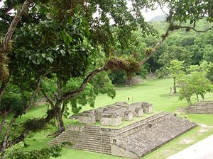
Description of the ruins
The site in Copan is known for producing a remarkable series of portrait stelae, most of which were placed along processional ways in the central plaza of the city and the adjoining "acropolis" (a large complex of overlapping step-pyramids, plazas, and palaces). The stelae and sculptured decorations of the buildings of Copán are some of the very finest surviving art of ancient Mesoamerica.
Many structures are elaborately decorated with stone sculptures, usually constructed from a mosaic of carved stones of a size that one person could carry.
The site also has a large court for playing the Mesoamerican ballgame. At its height in the late classic period Copán seems to have had an unusually prosperous class of minor nobility, scribes, and artisans, some of whom had homes of cut stone built for themselves (in most sites a privilege reserved for the rulers and high priests), some of which have carved hieroglyphic texts.
The buildings suffered significantly from forces of nature in the centuries between the site's abandonment and the rediscovery of the ruins. There have been numerous earthquakes -- none of the roofs of the stone buildings were intact when the site was rediscovered, and the hieroglyphic stairway had collapsed. The Copán river changed course and meandered, destroying part of the acropolis (revealing in the process its archaeological stratigraphy in a large vertical cut) and apparently wiping out various subsidiary architectural groups in the region. In the long period when the site was overgrown the buildings and sculptures suffered from the invasive thick jungle vegetation and periodic forest fires.
Archeologists have consolidated and restored many structures at the site.
Pre-Columbian history

The fertile Copán River valley was long a site of agriculture before the first known stone architecture was built in the region about the 9th century BC.
A kingdom seems to have been established in Copán in 159. It grew into one of the most important Maya sites by the 5th century. Large monuments dated with hieroglyphic texts were erected in the city from 435 through 822.
Xukpi was one of the more powerful Maya city states, a regional power, although it suffered a catastrophic defeat at the hands of its former vassal state Quirigua in 738, when the long-ruling Xukpi ruler Uaxaclajuun Ub'aah K'awiil (18 Rabbit) was captured and beheaded by Quirigua's ruler K'ahk' Tiliw Chan Yopaat (Cauac Sky). Though Copán's rulers began to build monumental structures again within a few decades, both cities withered in the face of unsustainable population growth bringing about the depletion of natural resources, factors that brought several of the Classic-Age Maya city-states to their end. The area continued to be occupied after the last major ceremonial structures and royal monuments were erected, but the population declined in the 8th century - 9th century from perhaps over 20,000 in the city to less than 5,000.
The ceremonial center was long abandoned and the surrounding valley home to only a few farming hamlets at the time of the arrival of the Spanish in the 16th century.
List of known Xukpi rulers

- 1. K'inich Yax K'uk' Mo' ("Great-Sun First Quetzal Macaw") before 435
- 2. "K'inich Popol Hol" ("Great-Sun ?"); c. 437
- 3. "Ruler 3", name unknown; c. 455
- 4. "Ku Ix" (possibly K'altuun Hix or Tuun K'ab' Hix); c. 465
- 5. "Ruler 5", name unknown; c. 476
- 6. "Ruler 6" (Muyal Jol ?); c. 485
- 7. B'alam Nehn, ("Jaguar Mirror"; "Waterlily-Jaguar") after 504-544
- 8. "Ruler 8" (Wi'-Ohl-?, "Head on Earth"); 532-551
- 9. "Ruler 9" (Sak-lu ?);551-553
- 10. "Moon Jaguar" (tzi-b'alam, "? Jaguar"); 553-578
- 11. Butz' Chan ("Smoke Serpent", "fire-eating serpent"); 578-628
- 12. Chan Imix K'awiil ("Smoke Jaguar"); 628-695
- 13. Uaxaclajuun Ub'aah K'awiil ("18 Rabbit"); 695-738
- 14. K'ak' Joplaj Chan K'awiil ("Smoke Monkey"); 738-749
- 15. K'ak' Yipyaj Chan K'awiil ("Smoke Shell"; "Smoke Squirrel"); 749-763
- 16. Yax Pasaj Chan Yopaat (aka "Yax Pac") 763-after 810
- (probably period where throne was vacant)
- 17? Ukit Took'; 822
- Royal ceremonial center of city abandoned by 984
The first sixteen names, from Yax K'uk' Mo' to Yax Pasaj Chan Yopaat, are depicted on Altar Q, an artifact that has provided researchers clues to the history and origins of Copán. [1]
Archaeological investigations

By the time of the Spanish conquest of Honduras, the site had long been overgrown by rainforest. Although this large ruined city was known locally since early colonial times, it remained largely unknown by the outside world until a series of explorers visited it in the early 19th century. Juan Galindo wrote a description of the ruins in 1834, which was published the following year. This sparked the interest of North American explorer and travel writer John Lloyd Stephens and English architect and draftsman Frederick Catherwood whose illustrated books describing Copán and other sites excited a great deal of interest in Mesoamerican antiquities among American and European scholars, and its publication is regarded as the commencement of modern Mayan studies which continue to this day.
The site was the subject of one of the first modern archeological surveys and excavations in the Maya area, conducted by the Peabody Museum of Archaeology and Ethnology of Harvard University from 1891 to 1900. In 1934, Sylvanus G. Morley struck a deal with the Honduran government that American archaeologists from the Carnegie Institution of Washington would receive 50% of the artifacts from the site in exchange for excavation and restoration. Further excavations and restorations were begun by the Peabody Museum again in the 1970s, followed by the Government of Honduras's Proyecto Copán beginning in the late 1970s and continuing to this day.
See also:
- Maya civilization
- Quiriguá
References
- Aguirre, Robert D. (2005). Informal Empire: Mexico and Central America in Victorian Culture, Minneapolis and London: University of Minnesota Press.
- Fash. William L. (2001). Scribes, Warriors and Kings: The City of Copán and the Ancient Maya, London: Thames and Hudson.
- QUT Media Office (2008-01-23). "QUT researcher discovers Maya mask splendour". News@QUT. Queensland University of Technology. Retrieved on 2008-01-25.
- Robicsek, Francis (1972). Copán, Museum of the American Indian.
- Rowbotham, Jill (2008-01-23), "1500-year-old Mayan paint job peeled back", The Australian (News Limited), http://www.theaustralian.news.com.au/story/0,,23093081-12332,00.html, retrieved on 2008-01-23
- Wyllys Andrews. E. and Fash. William L. (2005). Copán: The History of an Ancient Maya Kingdom, Santa Fe: School of American Research Press.
External links
- "Copan" at the Open Directory Project
- "Lost King of the Maya" companion site to PBS's "Nova" television documentary on Copán
- "Hieroglyphs and History at Copán" article by Mayanist epigrapher David Stuart at the Peabody Museum
- PAPAC, Proyecto Arqueologico para la Planificacion de la Antigua Copan (Copan Urban Planning Project), academic-sponsored project for preservation and documentation of the site