Connecticut River
| Connecticut River | |
| River | |
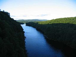 The Connecticut River looking north in the early evening, from the French King Bridge at the Erving-Gill town line in Western Massachusetts
|
|
| Country | USA |
|---|---|
| States | Connecticut, Massachusetts, Vermont, New Hampshire |
| Tributaries | |
| - left | Chicopee |
| - right | White River |
| Cities | Hartford, CT, Springfield, MA |
| Source | Fourth Connecticut Lake |
| - elevation | 2,660 ft (811 m) |
| - coordinates | |
| Mouth | Long Island Sound |
| - location | Old Saybrook, Connecticut[1] |
| - coordinates | |
| Length | 407 mi (655 km) |
| Basin | 11,250 sq mi (29,137 km²) |
| Discharge | for Thompsonville, CT |
| - average | 18,400 cu ft/s (521 m³/s) |
| - max | 95,400 cu ft/s (2,701 m³/s) |
| - min | 3,160 cu ft/s (89 m³/s) |
| Discharge elsewhere (average) | |
| - West Lebanon, NH | 6,600 cu ft/s (187 m³/s) |
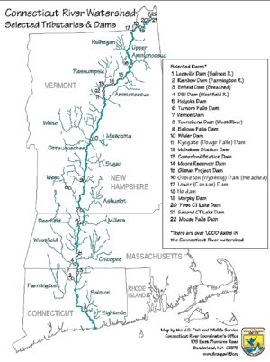 River map, with major tributaries and selected dams.
|
|
The Connecticut River is the largest river in New England, flowing south from the Connecticut Lakes in northern New Hampshire, along the border between New Hampshire and Vermont, through Western Massachusetts and central Connecticut into Long Island Sound at Old Saybrook, Connecticut. It has a total length of 407 miles (655 km), and a drainage basin extending over 11,250 square miles (29,100 km2). The mean freshwater discharge into Long Island Sound is 19,600 cubic feet (560 m3) per second. The river is tidal up to Windsor Locks, approximately 60 miles (97 km) from the mouth. The source of the Connecticut River is the Fourth Connecticut Lake in New Hampshire. Some tributaries include the Ashuelot, West, Miller's, Mill, Deerfield, White, and Chicopee rivers. (The Swift River, a tributary of the Chicopee, has been largely replaced by the Quabbin Reservoir which provides water to Boston.)
The river carries a heavy amount of silt, especially during the spring snow melt, from as far north as Quebec. The heavy silt concentration of the river forms a large sandbar near its mouth on Long Island Sound and has historically provided a formidable obstacle to navigation. The difficulty of navigation on the river is the primary reason that it is one of the few large rivers in the region without a major city near its mouth. The Connecticut River estuary and tidal wetlands complex is listed as one of the 1,759 wetlands of international importance under the Ramsar Convention on Wetlands.
Contents |
History

The river's name is the French corruption of the Algonquian word "quinetucket" and means long tidal river. The first European to see the river was the Dutch explorer Adriaen Block in 1614. As a result of this exploration, the Dutch named the Connecticut River the "Fresh River", and it was the northeastern limits of the New Netherland colony, and the original border between New Netherland and New England. The first English colonist to record his visit was Edward Winslow from the Plymouth Colony in 1632. In 1633 the English built a trading post on the site of Windsor, Connecticut, and the Dutch built one with a fort at the site of Hartford, Connecticut. As the number of English colonists increased, the Dutch abandoned their enterprise in 1654. The Fort at Number 4, now Charlestown, New Hampshire, was the northernmost English settlement on the river until the end of the French and Indian War in 1763. In the Treaty of Paris (1783), ending the American Revolutionary War, the new border between New Hampshire and what was to become the Province of Canada was defined to include the "northwesternmost headwaters of the Connecticut" . Because there are several streams that could fit that description, a boundary dispute led to the short-lived Indian Stream Republic, which existed from 1832 to 1835.
At first the broad, fertile valley attracted agricultural colonies, but the volume and fall of the river contributed to the rise of manufacturing in the valley. The greatest single drop of 58 feet (18 m) is at Holyoke, Massachusetts. Other important centers include Windsor and Hartford in Connecticut, Springfield, Massachusetts, the largest city on the river, Lebanon, New Hampshire, and Brattleboro, Vermont.

In 1829 the Enfield Falls Canal was opened to circumvent shallows on the Connecticut River. The locks built for this canal gave their name to the town of Windsor Locks, Connecticut.[2]
In the late 1800s the river was used for massive logging drives from the far north, particularly the Nullhegan River basin in Essex County, Vermont. These spring drives were stopped after 1915, when pleasure boat owners complained about the hazards to navigation.[3]
The Connecticut River Flood Control Compact was established in 1953 in response to severe flooding.
The Clean Water Act in 1965 has also had a major impact on the Connecticut River and its tributaries; since then, the river has been restored from Class D to Class B. It was designated as one of the American Heritage Rivers in 1997. The towns along the lower end of the river have enacted a cap on further development along the banks, so that no buildings may be constructed except on existing foundations.
Boating
The mouth of the river up to Essex is thought to be the busiest stretch of waterway in Connecticut. Some local police departments and the state Environmental Conservation Police patrol the area a few times a week. Some towns keep boats available if needed.[4]
Fish
|
|||||
The Connecticut River is a habitat to several species of anadromous fish, including the American shad, American eel, striped bass and the sea lamprey. The United States Fish and Wildlife Service is undertaking an effort to repopulate the river with another species of migratory fish, the Atlantic salmon. For more than 200 years, Atlantic salmon have been extinct from the river due to damming. Several fish ladders and fish elevators have been built to allow fish to resume their natural migration upriver each spring.

Angling the Connecticut
The headwaters of the Connecticut River are at the northern tip of New Hampshire, near the Canadian border. Much of the beginning of the river's course in the town of Pittsburg is occupied by the Connecticut Lakes, a chain of deep, cold water lakes that are home to lake trout and landlocked salmon.
The river itself holds native brook trout, rainbow trout, large brown trout, shad, small-mouth bass, striped bass, carp, catfish, American eel, and several other species of game fish. Landlocked salmon make their way into the river during spring spawning runs of bait fish and during their fall spawn. The river has fly-fishing-only regulations on 5 miles (8.0 km) of river. Most of the river from Lake Francis south is open to lure and bait as well. Two tail-water dams provide cold river water for miles downstream making summer fishing on the Connecticut River excellent.
Water quality testing project
There is now a website which provides water-quality reports twice a week, indicating whether various portions of the river are safe for swimming, boating and fishing.[5][6]
Tributaries


Listed from south to north by location of mouth:
|
|
Crossings

The Connecticut River is a significant barrier to travel between western and eastern New England. Several major transportation corridors cross the river including Amtrak's Northeast Corridor, Interstate 95 (Connecticut Turnpike), Interstate 90 (Massachusetts Turnpike), and Interstate 89. In addition, Interstate 91, whose route largely follows the river north-south, crosses it twice - once in Connecticut and once in Massachusetts.
See also
- Connecticut River Museum in Essex, Connecticut
- Lake Hitchcock, post-glacial predecessor to the Connecticut River
- History of Connecticut
- List of Connecticut rivers
- List of Massachusetts rivers
- List of New Hampshire rivers
- List of Vermont rivers
- The Great Attack - the burning of American ships on the Connecticut River at Essex in 1814
Additional reading

- Bacon, Edwin M. (1906). The Connecticut River and the Valley of the Connecticut: Three Hundred and Fifty Miles from Mountain to Sea. New York: G.P. Putnam's Sons. LCC F12.C7 B2. http://books.google.com/books?hl=en&id=faczgySbodgC&printsec=frontcover&source=web&ots=4122iUxeyg&sig=_pFq0IRYclCDdOkXevnr2e6A4QA&sa=X&oi=book_result&resnum=1&ct=result#PPR1,M1.
- Delany, Edmund Thomas (1983). The Connecticut River: New England's Historic Waterway. The Globe Pequot Press. ISBN 978-0871069801.
- Hard, Walter R. (1947). The Connecticut (Rivers of America). New York, Toronto: Rinehart & Company, Inc. LCC F12.C7 H3. ISBN 0932691277. http://books.google.com/books?id=dm4NAAAACAAJ.
- Roth, Randolph A. (2003). The Democratic Dilemma: Religion, Reform, and the Social Order in the Connecticut River Valley of Vermont, 1791-1850. Cambridge Mass.: Cambridge University Press. ISBN 9780521317733.
References
- ↑ USGS GNIS: Connecticut River
- ↑ Connecticut Heritage (Dorothy A. DeBisschop). The Canal at Windsor Locks. Retrieved January 20 2006.
- ↑ Wheeler, Scott (September 2002). The History of Logging in Vermont's Northeast Kingdom. The Kingdom Historical.
- ↑ [1]Kaplan, Thomas, "River Watchers, Tackling Speeders and Thin Budgets", article in The New York Times, Metro section, August 30, 2007, accessed same day
- ↑ The Connecticut River: A sewer runs through it
- ↑ Tri-State Connecticut River Targeted Watershed Initiative
External links
- Connecticut River Watershed Council
- The Connecticut River Museum
- Connecticut Riverfest
- Upper Valley Trails Alliance
- Connecticut River Joint Commissions
- Mouth or other endpoint (Long Island Sound) is at coordinates
- Source (Fourth Connecticut Lake) is at coordinates