Comodoro Rivadavia
| Comodoro Rivadavia | |
 |
|
| Nickname(s): The Capital of the Wind | |
| Motto: A city with energy. | |
| Country | Argentina |
|---|---|
| Province | Chubut |
| Department | Escalante |
| Founded | 1901 |
| Government | |
| - Mayor | Martin Buzzi |
| Area | |
| - Total | 548.2 km² (211.7 sq mi) |
| Elevation | 61 m (200 ft) |
| Population (2006) | |
| - Total | 140,628 |
| - Density | 254.35/km² (658.8/sq mi) |
| Time zone | GMT (UTC-3) |
| postal code | 9000 |
| Website: http://www.comodoro.gov.ar/index.php | |
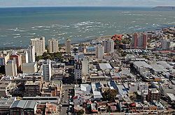
Comodoro Rivadavia is a city in the Patagonian province of Chubut in southern Argentina, located on the San Jorge Gulf, an inlet of the Atlantic Ocean, at the foot of the Chenque Hill. Comodoro Rivadavia is the most important city of the San Jorge Basin.
The city is often referred simply as Comodoro. It has a population of 137,061 as of the 2001 census [INDEC]. Although there are rumours that say that by now, the population could be of as much as 200,000 inhabitants due to the growth the city has experienced in the last years because of the oil industry and construction.
The city was at one time the capital of Comodoro Rivadavia Territory, which existed from 1943 to 1955. The territory was a part of Chubut before and after its creation. The city is now capital of the Escalante Department.
Comodoro Rivadavia is a commercial and transportation center for the surrounding region, the largest city of Chubut, and an important export point for a leading Argentine petroleum district. A 1,770 km pipeline conveys natural gas from Comodoro Rivadavia to Buenos Aires. The city is modern with the air of an oil-country boomtown.
Founded by decree on 23 February 1901 as a port for the inland settlement of Sarmiento, the first settler was Francisco Pietrobelli. Early settlers included Boers escaping British rule in South Africa, as well as Welsh settlers.
The town was named in honour of shipping minister Martín Rivadavia, a proponent of the development of southern Argentina. It has been prosperous since 1907, when a drilling crew searching for water struck oil at a depth of 539 m.
Oil production has begun to reduce in quantity but the area has been turning its attention to wind power. Windmills on Cerro Chenque and surrounding hills comprise South America's largest wind farm and provide 20% of Comodoro's energy needs.
The city is the home of the main faculty of the Universidad Nacional de la Patagonia San Juan Bosco. The Cathedral is the seat of the Diocese of Comodoro Rivadavia, of which the Bishop is, since 2005, Virginio Domingo Bressanelli. The Cathedral is dedicated to San Juan Bosco, the only cathedral in the world dedicated to the founder of the Salesian Order. It was inaugurated in 1979 although the crypt had been dedicated in 1949.
Rada Tilly is a beach resort and now suburb 12 km south of Comodoro. The National Museum of Petroleum is located in the General Mosconi neighbourhood 3 km north of central Comodoro Rivadavia. It was opened in 1987 by the state-owned oil company YPF, which was later privatized (see Repsol YPF).
Comodoro Rivadavia is served by General Enrique Mosconi International Airport (Airport Code CRD/SAVC) with daily flights to Buenos Aires and many other Patagonian cities, as it is the main hub of LADE.
Contents |
History
The urgency to define short routes to transport products from Colonia Sarmiento and bring them to that village created the necessity of a port in the area of San Jorge gulf. This necessity made possible the foundation of Comodoro Rivadavia, today capital of petroleum in Argentina. The first governor of Gobernación Nacional del Chubut was Colonel Jorge Luis Fontana, who travelled around the whole extension attributed to Chubut commanding a numerous group of Welsh immigrants in 1885. American researcher Junius Bird and Finnish V. Aurer respectively confirmed the existence of a Tehuelche prototype who lived in the sands of Rada Tilly some 9000 years ago. This information was confirmed by Father Brea, who some years ago contributed to this theory with the discovery of utensils and human remains near Rada Tilly.
It is widely known that the Tehuelche who came from the north of Patagonia during warm summer days used to make a halt where Rada Tilly is today. An English marine called Fitz Roy was the first to mention its existence in a navigation chart.
On 10th March 1889 Francisco Pietrobelli, accompanied by the Tehuelche Sainajo and Marcelo Pereira, came to Rada Tilly following Fitz Roy's navigation charts in search of an anchoring place to set up a deep water port where deep draft ships could stop to supply the flourishing Colonia Sarmiento.
In March 1891 Captain Martín Rivadavia was the first Argentine marine who anchored his corvette in Rada Tilly, while he was recognizing the area to control the displacement of the Chilean Army in the Argentine south. The village was named after the Spanish marine Francisco Everardo Tilly y Paredes, who during 1794 and 1795 gave combat and defeated the Portuguese army in the river Plate. However, reality indicates that it was the Spanish marine Juan de la Concha who anchored in Rada Tilly in command of a brig.
The beach village Rada Tilly was founded on 24th July 1948, and today has approximately 3450 inhabitants.
Before that, in 1890, the corvette "La Argentina" commanded by Commodore Martín Rivadavia arrived near mount Chenque in an exploring mission and settled an anchorage place called now Kilometro 5, Caleta Córdova or Punta Borjas. On 26th June, Pietrobelli completed the construction of the first storage shed in the place indicated years before by a Molle trunk, and on 23rd February 1901 by decree of the national government gave to this village the name Comodoro Rivadavia in homage to the illustrious marine, grandson of the great statesman Bernardino Rivadavia and firs Argentine president. The oil exploitation, initiated by chance in 1907, gave to Comodoro Rivadavia a vertiginous growing rhythm. By the end of 1919, most of the 1719 workers were given accommodation in small metal sheet houses without any heating or electric light with temperatures below zero and winds near 100 km./h. The creation of Yacimientos Petrolíferos Fiscales in 1922 completed and emphasized the development of the town, and by the end of the 50s, the government promoted an oil campaign and fostered the installation of numerous foreign companies. The city evolved around this and even today when this panorama has changed substantially, it is still called National Oil Capital. Some of its governors were: Gral. Angel Solari: (31-05-44 to 15-11-45) Gral. Armando S. Raggio: (16-11-45tol 31-12-48) Gral. Julio Alberto Lagos: (31-12-48 to 23-06-50) Gral. Salvador M. Muller: (23-06-50 to 14-11-51) Gral. Fernando J. Carlés: (14-11-51 to 14-04-53) Gral. Italo H. Dell'Oro: (08-05-53 to 25-07-55)
Population
Comodoro Rivadavia had a population of 135,632 inhabitants in 2001, which represented an increase of 9.2% compared to the 1991 census total of 124,104. This increase is a little below the national average. The city size places Comodoro Rivadavia as the 20th largest city of the country and the largest in South Patagonia, which goes from Chubut to Tierra del Fuego.
Urban Areas
Comodoro Rivadavia is the biggest city located to the south of the Colorado River. The city developed from the oil camps which evolved into neighbourhoods.
The city is divided into three main areas: North Area, South Area and Downtown Area.
The South Area is the most populated in the city. The neighbourhoods are: Jorge Newbery, San Martin, 1311 Viviendas , Cerro Solo, Ñaco, San Cayetano, Francisco Pietrobelli, Las Flores, La Floresta, Máximo Abasolo (where you can find one of the main bus stations of the city).
Moure, Cordón Forestal (where you can find a lot of beautiful fields), Quirno Costa, Maestro Isidro Quiroga, Juan XIII, San Isidro Labrador, 9 de Julio, 13 de Diciembre, Julio A. Roca, (where you can find the prestigious Military School, General Roca ), Juan Manuel de Pueyrredon, 30 de Octubre (where you can find the biggest bus station of local lines in the city), LU4 (where you can find the famous Sports Clubs: Huracán and Portugués), Abel Amaya, Industrial (where you can find the most important Oil Companies and Industries), Stella Maris, Ceferino Namuncurá, Jose Fuchs, Balcón del Paraiso (where you have the principal vantage point of the city, in which the view is magnificent), Covipex, Rincón del Diablo, 311 Viviendas and Humberto Beghin.
The Downtown area is where you can find whatever you need. The main street is San Martin Street, where you can find most of the shops, but other important streets are: Rivadavia, 9 de Julio, España, Alem, Chacabuco, Francia, Italia, Ameghino, Hipólito Yrigoyen, Belgrano, Sarmiento, just to name a few.
This Area is divided into: Centro, Loma and Civico neighbourhood. It is incredible the enormous variety of shops and places that you can find in the Downtown Area: The Regional Hospital, health clinics, schools, institutes (music, languages, computers), Coliseo Cinema, Español Movie Theatre (see picture), electronic devices stores, clothes stores, jeweler’s shops, DVD rental houses, pharmacies, music shops, bakeries, kiosks, The Local Municipality, The Court House, service stations, libraries, bookshops, tattoo shops, shoe-shops, etc.
Something unique about the Downtown Area is that it is surrounded by the sea and the Chenque Hill.
The North Area is the most beautiful area of the city because of its green and clean spaces, squares and peaceful population.
This area is divided into: - 3rd Kilometre, where you have the neighbourhoods: General Mosconi neighbourhood (where you can find the Oil Museum, schools, supermarkets, sports club Ingeniero Luis A. Huergo), Ameghino (where you can find the football club C.A.F.A, shooting house and the Stadium), Saavedra, Nuestra Señora de la Divina Providencia (where you can find the Santa Lucia Rugby Club and the Golf court), San Martin Este and San Martin Oeste. - 4th Kilometre, where you can find the National University Patagonia San Juan Bosco. - 5th Kilometre, where you can find the neighbourhoods: Castelli, Rodriguez Peña, Presidente Ortiz, Usina, Ferrocarril (there is a football field, Ferro Club), Azcuénaga (there is the football Club, U.S.M.A.) and Las Orquideas (where you can find the cemetery). - 8th Kilometre, where you can find the neighbourhoods: Don Bosco, Restinga Ali, Caleta Cordova (a fishing town mainly), Standard North- South- Centre and Gobernador Fontana. - 6th Kilometre, where the neighbourhoods are Prospero Palazzo (where you find the International Airport General Mosconi) and Petroleros Privados. - Other neighbourhoods in the area: Laprida, Güemes, Sarmiento, Manantial Rosales, Ciudadela, Diadema (which is a beautiful area divided into the Church and the School neighbourhoods). - 20th Kilometre, Astra neighbourhood.

Entertainment
Comodoro Rivadavia is a city which offers a great deal of entertainment for all ages. Regarding leisure activities you can visit first of all the Oil Museum.
You can also visit the old lighthouse located eight kilometres away from the downtown, close to the fishing town of Caleta Córdova. It is quite quaint and mysterious.
If you are interested in races, you can go to the horse tracks located in Rada Tilly Village, and admire the beautiful horses which compete there.
One unique place that you shouldn’t miss is the Windmill Farm, which is really breath-taking and the only one of its kind in South America.
Despite all the cultural and historic spots, Comodoro also offers a wide range of nightlife activities. The places which attract more young and middle-aged people are the pubs and clubs.
Some recommendations:
• Draw Pool Pub: It has a great number of pool tables, a wide variety of drinks and even a good menu if you want to eat something.
• El Viejo Galpón Pub: The atmosphere is warm and comfortable, it also has a good variety of drinks, but the best attractions are the local bands which perform on stage.
• El Sótano Pub: It is one of the oldest pubs in Comodoro, a huge amount of bands played there (local and national), and there you can play a game of pool, while listening to a live band performing.
• Estación 23 Disco: This place is mostly for teenagers aged 15-20, good music and intimate atmosphere.
• Gigante Megadisco: If you like dancing and you enjoy all kinds of music you must go to this place.
• Géminis Disco: If you are older than 25 and you want to have a great time.
• ELE: The newest disco in the city (2007), it is very modern and it also has a restaurant and a huge variety of drinks.
All these places are located in the downtown of the city, so they are of very easy access.
Local rock bands
It is worth mentioning the local rock bands, which are a huge part of the history of our city. “113 Vicios” it’s a band which edited two albums (Crudo and Disco Negro) in its short but prestigious performance. After a few years the band broke up.
“La Rueda” It is a very popular band that plays rock music, original songs and covers. They are still waiting for the huge breakthrough opportunity, but in the city they are very famous.
“Noelia Soto” was an unknown local singer who won the Second place in the 2006 Latin American Idol. She has a huge future ahead, because of her sweet voice and talent.
“EGO” (ex-Insidia), it is a local band that plays mostly alternative music and nu-rock style. They’re very talented and its style is unique in the city. They have great original songs and they also play covers of bands like: Chevelle, Cabezones, Silverchair and Soda Stereo, well-known national bands.
Other great bands: “Axioma”, “Metodo”, “Interfecto”, “Doutdes”, “All hate”, Careo”, "Quasimoda", “Arcada”, just to name a few.
Places where you can see local and national bands: - Sports Club Ingeniero Luis A. Huergo (capacity of 5000 people) - Gimnasia y Esgrima Club (Capacity of 3000 people) - Sotano Pub (capacity of 200 people) - Centro Gallego (capacity of 2000 people) - El Viejo Galpon Pub (capacity of 200 people)
Economy
Industry and Commerce
The commercial and industrial activities of the city are the most important in the region. The main activities of the city are: production of chemical products, elaborated concrete, salter, fabrication of industrial houses, shipyard, metallurgical products, refrigerated products, industrial factories, casting, textile industry, blocks and bricks, and cement.
Oil Industry
The oil production started in Chubut in 1907, when a drilling rig which was looking for water discovered oil in Comodoro rivadavia.
In that year the oil activity started in Argentina, which adopted the 1886 national mining code (Codigo de Mineria de la Nación). This code established that the oil fields belonged to the State, and they could also be exploited by concession.
In 1922 YPF (Yacimientos Petrolíferos Fiscales), the first state-owned oil company in the world, was created by Hipólito Yrigoyen's government. This company helped the society by improving the construction of houses, providing new jobs and health care. Engineer Enrique Mosconi was in charge of running the company.
Until 1933, 1,648 wells had been drilled in Comodoro Rivadavia . The 88.9% of them were economically productive.
In 1935 the First Oil Law was passed. It established that the National and provincial States would receive as contribution the 12% of the Gross Product from all oil drilling, which is still in effect.
In 1958, Law Number 14,773 was passed and it established that the Government had exclusive ownership over all oil fields.
The most important oil fields discovered during the 60's were El Huemul and Piedra Clavada. At the beginning of the same decade twenty wells were drilled.
Between 1977-1986, 100 million m3 of oil were drilled from San Jorge gulf, in the meantime the oil reserves reached 40 million m3 . In 1979 the San Jorge gulf production reached 10.124.022 m3 of oil .
Until 2001, 5,300 wells were drilled, 3000 of them were economically productive . As a result of the exploratory activities developed during the century, the remaining reserves reach 182.017 million m3 of oil.
Nowadays San Jorge gulf is the leader in oil extraction. 46.000 mts3 per day are extracted in the zone; it represents 46% of total crude oil in the national territory.
Thanks to the oil activity, the commercial activity was developed. A big number of foreign people, and from other provinces of Argentina, moved to the city to set up their shops. For this reason Comodoro Rivadavia is considered one of the cities with the highest rate of consumption. This has helped different businesses to develop. This progress is reflected in the downtown: there is a lot of commercial activity, different options in entertainment, restaurants and very busy four-star hotels.
Port of Comodoro Rivadavia
Geographic location
Comodoro Rivadavia is situated in the south of Argentina in the province of Chubut, on the coast of San Jorge Gulf.
It was necessary to create a port in the area of San Jorge Gulf in order to have shorter routes for transporting products from and to the town of Sarmiento, situated 180 km away from the city of Comodoro Rivadavia.
Geographic location:
Comodoro Rivadavia: Latitude 45° 51´ S; Length 67° 28´ W. Caleta Olivia: Latitude 45° 46´ S; Length 67° 22´ W. Caleta Córdova: Latitude 45° 43´ S; Length 67°31´ W. Time zone: GMT -3
Nautical information:
Argentine map course: Part 2. Cartography S.H.N. Letters N ° 30.75 H314 and H310.
Climate:
Average temperatures: Annual 12.7 °C Maximum Average: January 25.5 °C Minimum Average: July 23.1 °C Predominant winds: W, SW Precipitations: Average annual 189 mm. Month of Maximum Precipitations: May Fog: 4 days/year
Foundation and History of the Port
History of Comodoro Rivadavia Port
Since 1908, the small and weak port Maciel received passengers and shipments that arrived at the city of Comodoro Rivadavia. It was built of wood and only could support small ships.
Comodoro Rivadavia needed a port in order to transport and receive shipments especially to the north, because the sea was the only way to do that. The Engineer Enrique Ducos presented a project to gain land from the sea, between Coronel Restinga, situated 3 km away from the port, to the coast close to downtown, where shipsides would be built.
In 1923, the construction of the port started and Engineer Ducos leaded the works, but he had to deal with a lot of troubles. The most important was the fact that the provincial government didn’t provide enough money to pay workers, so Ducos had to manage the construction with only one group of workers all the year long.
In spite of having lots of obstacles, the dock was finished and it could finally be used for long passenger ships and battleships. This was very much celebrated by the people of Comodoro Rivadavia.
A few years later, the port received around 100.000 people per year. They travelled to Bahía Blanca or Buenos Aires.
On the other hand, the port allowed to transport near 200.000 tons of fruits and other kind of shipments.
In 1926 the construction was stopped, but in 1928 it was resumed. The inhabitants of Comodoro Rivadavia held high hopes and saw the port as a necessary tool for the growth of the city.
In 1934 Maciel Port was finally destroyed, but the construction of the new port had to deal again with lots of problems, because the national authorities did not send the necessary funds to support Ducos’s project.
The role of the Port in the Tourist Activity
Besides being an attractive supply for the international trade and its privileged condition of head of Ocean to Ocean Corridor, it presents advantageous characteristics for the tourist activity.
The Port of Comodoro Rivadavia is in excellent conditions to be inserted in the integrated circuits of world-wide cruises. The port facilities, activities and services are together with tourism essential benefits that contribute to promote a new marine awareness. Besides the port offers recreation and cultural activities.
The reevaluation of the port has derived in an increase of tourist activities. Tourist guide offers, to the inhabitants and tourists, interpretative and explanatory information comprising different axes of information.
Free trade zone
The port project has been complemented with other productive possibilities. The free trade zone has been one of them. It is a special area, free of taxes, that has become an attractive location for productive projects which are focused on exportation.
This subject has been discussed extensively by the local politicians since the last decade of 20th century.
Diversified supplies
The spectacular surroundings of the harbor, together with the geologic and morphologic characteristics of the area, extensive beaches and ample landscape, invite people to develop outdoor activities. Among these attractive activities we can mention: fishing, beach sports, landyachting, sailing, navigation with oar, surfing, speedboat racing and water-skiing.
Tourism is gradually becoming a productive sector. In that respect, a planning of natural and cultural sustainable development of all resources has been elaborated. The port was inserted in that plan as patrimony of the region.
Port Facilities
Comodoro Rivadavia’s port is the most complete port of Patagonia. The transportation of regional commodities, is the most important activity connected with the ocean to ocean corrirdor.
The National Road Number 3 runs along the east coast and the National Road Number 26 connects the city with Chile, to the West. This becomes an important communication line connectig east and west, or the Atlantic with the Pacific Ocean and it is made mostly by paved roads.
The ocean to ocean corridor is fundamental for commerce, tourism and passengers circulation. It joins, in less than 600 km and a few hours of traveling, Chacabuco Port in the Pacific Ocean with the Comodoro Rivadavia Port in the Atlantic Ocean.
There is a border pass called “Hito 50” or Paso Huemules (480 meters above sea level) which can be used all year round because it is not affected by the winter snow, due to its lower position.
This route has an enormous relevance because it links communities, integrates and projects two countries promoting the regional growth.
The port has a shipyard in a privileged area. The shipyard has two parallel industrial facilities of 70 meters long and 4 meters wide. This allows the repair and building of ships in a roofed space without the weather affecting the activity.
The shipyard has three travelling cranes of 8 tons each. Works made in the shipyard include the building of eolic mill towers and oil buoys.
The port facilities include:
• The principal Port situated near the downtown. Its extreme point called Punta Borja, was designed to receive ships up to 181 meters length and 10 meters depth.
The port has a pier of 216 meters long, which was built to meet the demand of the transportation of commodities, deep-sea fishing and naval repairs.
• Caleta Cordova's low tide pier is located in the north of Comodoro Rivadavia city, over the coast of Caleta Cordova’s neighborhood. This pier meets the demand of artisan fishing.
• Repsol-YPF's pier, located in the south of General Mosconi neighborhood, is used for unloading fuel. The unloading is over 29.000 liters per month.
• Caleta Olivares's facilities are used to load crude oil. It has four mooring buoys and one bell buoy. The depth of this area is 9 meters.
• Caleta Cordova's facilities for loading crude oil include one charge buoy and four mooring buoys. These facilities located 3 miles (4.8 km) away from the coast are used for mooring ships up to 100.000 tons and 11 meters depth.
Production of Concrete
The city counts with a factory that produces concrete, property of Petroquimica Comodoro Rivadavia S.A. It produces different types of concrete: Standard Portland, Puzolanic, BCA, ARI, bricklaying concrete Caltex, concrete for oil industry. The total production of concrete for the year 2002 was of 228,000 tons.
Eolic Energy
The eolic park of Comodoro Rivadavia has a capacity of 18,820 kW with 26 generators. It is the most important in Latin America. Plans exist to connection it the national energy, which could allow the sale of energy to other regions.
Fishing
Species of Argentine Patagonian
Predominant species in San Jorge gulf are: Pink Cuskeel, Patagonian Cod, Tope Shark, Patagonian Smooth Hound, Flounder, Argentine Hake, Long Tail Hake, Argentine Sea Bass, Notothenia, Butterfish, Silver Side, Elephant Fish, Skate, Patagonian Blenny, Blackbelly Rosefish, Brazilian Sand Perch, Silver Warehou. Among crustacean and mollusks, the following species stand out: spider crab, craw-fish and squid.
In order to obtain current information about volumes of fishing, you can access the Agriculture, Animal Raising, Fishing and Food Secretary of Argentine Republic web page, SAGPyA, Ministerio de Economía.
Environmental Impact of Fishing
Fishing in Argentina shows an urgent need of decreasing the overfishing and the accidental capture of sea mammals and birds. The conventional arts of fishing don’t always allow fishermen to extract the wanted species. As a result other unwanted species are fished and accidentally killed. Every year tonnes of dead or dying animals are thrown overboard the fishing ships. This is one of the main threats for many species of mammals, turtles and sea birds that are in danger of becoming extinct around the world.
This kind of economic activity in Patagonia is the one with the highest impact on sea ecosystems. Especially in coastal areas, where artician fishing predominate, trawling turns into mortal traps for sea lions, dolphins, whales and seals. The fishing methods that cause mortality use mesh nets; lift nets and drag nets. The mesh nets are used for anchovy and mackerel whereas the drag nets for corvine. Many species are captured in an accidental way by these nets, like the porpoise, the dark dolphin, one haired dolphin and the ordinary dolphin. In trawling fishing occasionally sea lions get drowned by trying to capture fishes in the nets.
The minimum, lowest annual mortality of small cetaceous in mesh nets is estimated in 170-200 individuals, whereas the numbers of individuals lift nets are between 50 and 100.
Another activity that has caused big mortality has been the capture of sea mammals to be used as bait in the spider crab traps in the region of Magallanes strait and in Tierra del Fuego’s canals. As a result alternative baits are being looked for.
Another environmental problem related to fishing in Patagonia is the waste generated from fishing and its effects on biodiversity. Some research made in 1993 revealed that for each specimen put in the market, four are returned dead to the sea. In this way, there are not only threatened species of a commercial interest, like prawn and hake, but also species not required in the market, which are very important for the balance of the sea ecosystem of Patagonia.
The coastal fleet unloads 27,000 tons per year in the provinces of Chubut’s ports, Santa Cruz and Rio Negro; but there are 9,000 tons of discarded species in the same places.
On the other hand, it has been verified that fishing boats don’t respect fishing bannings established. During the summer the capture of prawn is banned. However many boats illegally get into the south side of San Jorge Gulf for the capture of prawn. This has caused big mortality among the young prawn.
Fishing Nets
The fishing nets are thrown near the surface and trawled along the bottom of the sea. Lift nets is the most efficient surface net. It’s a long net similar to a hanging curtain with rubber floating rings which are trawled in circle around a fish shoal. It is closed at the bottom and pulled up like a bug.
Mesh nets are big enough to let the fish’s head go through it and hook it. Trawling nets are used to capture fish in deep water, like cod and this kind is the most important in commercial fishing. This kind of net is sock-shaped and is throwned by two cables . Trotlines are long heavy cables attached to ropes with hooks where a bait is put and are used for fishing in the surface or deep water. These can be several kilometres long and usually are fixed to an anchored buoy or throwned from the ship. Once trotlines are loaded , these are lifted up by means of a pulley.
Sea birds
Sea birds, particularly, albatross and petrels are suffering from fishing methods in Argentina. Over the last years sea birds are in real danger of becoming extinct worldwide. These species put only one egg per season. Therefore they cannot recover quickly from mortality.
The major cause of death is the accidental capture because of trotlines. They get stuck in the hooks that are used to capture fish and die by sinking with the fishing line. Attracted by the shinning of hooks in the water which are similar to the fish, sea birds get trapped. The strategies in order to reduce the capture of sea birds are several. One of them consists in using some mechanisms that drive the birds away. Some of them are: Scarecrow lines, lines with hanging ribbons that move with the wind.
Strategic dumping of fishing waste. If waste would be dumpped on the opposite side where the hooks are placed, the capture of these birds could be avoided. Another alternative would be the unfrozen bait which doesn’t float and attract much the birds. Nineteen out of the twenty known species are threatened of becoming extinct.
Illegal Fishing
In order to avoid the increase of illegal fishing of squid in Comodoro Rivadavia's Port, the provincial government and SENASA (government organization that controls food quality) have produced a regulation which organize and control the procedure for international transportation of fish.
The ships with flags different from the Argentinian, are allowed to fish in waters further than the continental platform; and the provincial government allows them to load their shipments, collect them in containers and move them by routes towards other cities where commercial ships will take the squid to export destinations.
It is not allowed to foreign fishers to sell what they have captured neither negotiate with processing plants in the city of Comodoro Rivadavia or any other city in the region, because this might have a negative impact on the local economy.
Sports
The most important sports in the city of Comodoro Rivadavia are basketball, football (soccer) and car racing, among others such as landyachting, judo, rugby and athletics.
One of the most representative sports is basketball. Comodoro Rivadavia is the home of the most important basketball team of the region and 2006 National League champion, Gimnasia y Esgrima Comodoro Rivadavia also called "The Green Magic". The club it is not only formed by local players, the members are from all over the world, USA for example. Other important basketball clubs are Nautico and Federacion Deportiva.
The other important sport is football (soccer). The most popular clubs are CAI (Comisión de Actividades Infantiles), which is ranked in the B National League of football and Huracán de Comodoro Rivadavia, which plays in the Argentine Tournament "B". Both teams have a great number of followers in the city.
Comodoro Rivadavia also has a football league in which many teams participate; the principal teams are Jorge Newbery, Huracal and Petroquimica. There are other clubs such as: Tiro Federal, Universitario, Ferroviario, Usma, Tiro Federal and Portugues, which are located in the First A League of Comodoro Rivadavia. Although they are not as prestigious, they are a huge part of the culture and the entertainment of the city. Each of these clubs has their own football court on different neighbourhoods.
Landyachting has become very popular in the city and the beaches of Rada Tilly, together with the windy climate, are ideal to practise the sport. The sport started in Argentina in the 1960s. Rada Tilly Village is the best place in the country to practice this sport, at any time of the year.
This sport consists of a three wheeled car and a sail similar to the one that is used to practice windsurfing. The speed can reach 180 km per hour that is why it’s important to have an excellent ability to manage the car. Pablo Reyes is one of the most important pilots, and he was the first one to get on a car built and designed by himself. The World Championship of Landyachting was held in 2008 in Rada Tilly.
External links
- (Spanish) Municipality of Comodoro Rivadavia - Official website.
- (Spanish) History of Comodoro Rivadavia.
- Municipal information: Municipal Affairs Federal Institute (IFAM), Municipal Affairs Secretariat, Ministry of Interior, Argentina.
|
|||||||||||
|
||||||||||||||||