Columbia River
| Columbia River | |
| Wimahl | |
| River | |
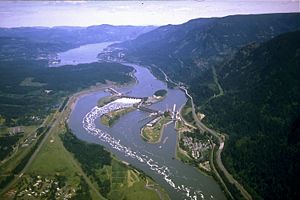 Bonneville Dam, in the Columbia River Gorge
|
|
| Name origin: Captain Robert Gray's ship, Columbia Rediviva | |
| Nickname: Big River | |
| Countries | Canada, United States |
|---|---|
| States | Washington, Oregon |
| Provinces | British Columbia |
| Tributaries | |
| - left | Spillimacheen River, Beaver River, Illecillewaet River, Incomappleux River, Kootenay River, Pend Oreille River, Spokane River, Snake River, Deschutes River, Willamette River |
| - right | Kicking Horse River, Blaeberry River, Canoe River, Kettle River, Sanpoil River, Okanogan River, Yakima River, Cowlitz River |
| Cities | Revelstoke, BC, Tri-Cities, WA, Portland, OR, Vancouver, WA |
| Source | Columbia Lake |
| - location | British Columbia, Canada |
| - elevation | 2,690 ft (820 m) [1] |
| - coordinates | [2] |
| Mouth | Pacific Ocean |
| - elevation | 0 ft (0 m) |
| - coordinates | [3] |
| Length | 1,243 mi (2,000 km) [4] |
| Basin | 258,000 sq mi (668,000 km²) |
| Discharge | for mouth (average); max and min at The Dalles, Oregon, 188.9 miles (304.0 km) from the mouth |
| - average | 265,000 cu ft/s (7,500 m³/s) [5][6][7] |
| - max | 1,240,000 cu ft/s (35,100 m³/s) |
| - min | 12,100 cu ft/s (300 m³/s) |
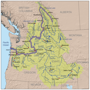 Columbia River watershed
|
|
The Columbia River (known as Wimahl or Big River to the Chinook-speaking natives who live on its lowermost reaches)[8] is the largest river in the Pacific Northwest region of North America. It is named after the Columbia Rediviva, the first ship from the western world known to have traveled up the river.[9] It stretches from the Canadian province of British Columbia (BC) through the U.S. state of Washington, forming much of the border between Washington and Oregon before emptying into the Pacific Ocean. The river is 1,243 miles (2,000 km) long, and its drainage basin is 258,000 square miles (670,000 km2).
Measured by the volume of its flow, the Columbia is the largest river flowing into the Pacific from North America and is the fourth-largest river in the U.S. The river's heavy flow, and its large elevation drop over a relatively short distance, give it tremendous potential for the generation of electricity. It is the largest hydroelectric power producing river in North America with fourteen hydroelectric dams in the U.S. and Canada, and many more on various tributaries.
The Columbia and its tributaries are home to numerous anadromous fish, which migrate between fresh water streams and the Pacific Ocean. These fish—especially the various species of salmon—have been a vital part of the river's ecology and the local economy for thousands of years.
The Columbia has been heavily developed to serve human purposes since the arrival of numerous American and European settlers in the 19th century. The development, commonly referred to as taming or harnessing of the river, includes dredging for navigation by larger ships; the construction of dams for power generation, irrigation, navigation, and flood control; nuclear weapons research and production; and the generation of nuclear power. These projects have come into conflict with ecological conservation numerous times, impacting fish migration and resulting in industrial pollution.
Contents |
Course
The Columbia flows 1,243 miles (2,000 km) from its headwaters in British Columbia (BC), Canada, to the Pacific Ocean on the Oregon–Washington border in the United States. It drains an area of about 265,000 square miles (690,000 km2), including the discharge of its numerous tributaries.[5] Its drainage basin covers nearly all of Idaho, large portions of BC, Oregon, and Washington, and small portions of Montana, Wyoming, Utah, and Nevada. Roughly 745 miles (1,200 km) of the river's length and 85 percent of its drainage basin are in the U.S.[10] The Columbia is the twelfth-longest river and has the sixth-largest drainage basin in the U.S.[5] In Canada, where the Columbia flows for 498 miles (801 km) and drains 39,700 square miles (103,000 km2), the river ranks 23rd in length,[11] and its basin ranks 13th in size.[12]
The Columbia shares its name with nearby places, such as British Columbia, as well as with landforms and bodies of water. Columbia Lake, 2,690 feet (820 m) above sea level, and the adjoining Columbia Wetlands form the river's headwaters in the southern Rocky Mountain Trench. The trench is a broad, deep, and long glacial valley between the Canadian Rockies and the Columbia Mountains in British Columbia. For its first 200 miles (320 km), the Columbia flows northwest along the trench through Windermere Lake and the town of Invermere, a region known in BC as the Columbia Valley, then northwest to Golden and into Kinbasket Lake. Rounding the northern end of the Selkirk Mountains, the river turns sharply south through a region known as the Big Bend Country, passing through Revelstoke Lake and the Arrow Lakes. Revelstoke, the Big Bend, and the Columbia Valley combined are referred to in BC parlance as the Columbia Country. Below the Arrow Lakes, the Columbia passes the cities of Castlegar, located at the Columbia's confluence with the Kootenay River, and Trail, two major centres of the West Kootenay region. The Pend Oreille River joins the Columbia about 2 miles (3 km) north of the U.S.–Canada border.[13]

The Columbia enters eastern Washington flowing south and turning to the west at the Spokane River confluence. It marks the southern and eastern borders of the Colville Indian Reservation and the western border of the Spokane Indian Reservation.[14] The river turns south after the Okanagan River confluence, then southeasterly near the confluence with the Wenatchee River in central Washington. This C-shaped segment of the river is also known as the "Big Bend". During the Missoula Floods 10,000 to 15,000 years ago, much of the floodwater took a more direct route south, forming the ancient river bed known as the Grand Coulee. After the floods, the river found its present course, and the Grand Coulee was left dry. The construction of the Grand Coulee Dam in the mid-20th century backed the river up, forming Lake Roosevelt, from which water was pumped into the dry coulee, forming the reservoir of Banks Lake.[15]
The river flows past The Gorge Amphitheatre, a prominent concert venue in the Northwest, and then past the Hanford Nuclear Reservation. Hanford Reach, a section of the Columbia between Priest Rapids Dam and the Tri-Cities, is the only U.S. stretch of the river that is completely free-flowing, unimpeded by dams, and not a tidal estuary. The Snake River and Yakima River join the Columbia in the Tri-Cities area. The Columbia makes a sharp bend to the west at the Washington–Oregon border. The river defines that border for the final 309 miles (497 km) of its journey.[16]
The Deschutes River joins the Columbia near The Dalles. Between The Dalles and Portland, the river cuts through the Cascade Mountains, forming the dramatic Columbia River Gorge. Along with the Klamath River in southern Oregon and the Pit River in northern California, the Columbia is one of only three rivers to pass through the Cascades. The gorge is known for its strong and steady winds, scenic beauty, and its role as an important transportation link.[17]
The river continues west, bending sharply to the north-northwest near Portland and Vancouver, Washington, at the Willamette River confluence. Here the river slows considerably, dropping sediment that might otherwise form a river delta. Near Longview, Washington and the Cowlitz River confluence, the river turns west again. The Columbia empties into the Pacific Ocean just west of Astoria, Oregon, over the Columbia Bar, a shifting sandbar that makes the river's mouth one of the most hazardous stretches of water to navigate in the world.[18]
Discharge
With an average flow at the mouth of about 265,000 cubic feet per second (7,500 m³/s),[5] the Columbia is the largest river by volume flowing into the Pacific from North America[19] and is the fourth-largest by volume in the U.S.[5] Its drainage basin covers 258,000 square miles (670,000 km2). The average flow where the river crosses the international boundary between Canada and the U.S. is 99,000 cubic feet per second (2,800 m³/s) from a drainage basin of 39,700 square miles (103,000 km2).[20] This amounts to about 15 percent of the entire Columbia watershed. The Columbia's highest recorded flow, measured at The Dalles, was 1,240,000 cubic feet per second (35,000 m³/s) in June 1894, before the river was dammed.[21] The lowest flow recorded at The Dalles was 12,100 cubic feet per second (340 m³/s) on April 16, 1968, and was caused by the initial closure of the John Day Dam, 28 miles (45 km) upstream.[21] The Dalles is about 190 miles (310 km) from the mouth; the river at this point drains about 237,000 square miles (610,000 km2) or about 91 percent of the total watershed.[21] Flow rates on the Columbia are affected by many large upstream reservoirs, many diversions for irrigation, and, on the lower stretches, reverse flow from Pacific Ocean-induced tides. The National Weather Service issues tide forecasts for eight places along the river between Astoria and the base of Bonneville Dam.[22]
Geology

- See also: Geology of the Pacific Northwest and Missoula Floods
When plate tectonics pushed North America away from Europe and into an ancestral Pacific Ocean, the Pacific Northwest was not part of the continent. Collisions with islands, reefs, and sea floor slowly created this large region of North America between 150 and 90 million years ago.[23] The general outline of the Columbia Basin was not complete until between 60 and 40 million years ago, but it lay under a large inland sea later subject to uplift.[24] Between 40 and 20 million years ago, in the Eocene and Miocene eras, tremendous volcanic eruptions frequently modified much of the landscape traversed by the Columbia.[25] The lower reaches of the ancestral river passed through a valley near where Mount Hood later arose. Carrying sediments from erosion and erupting volcanoes, it built a 2-mile (3.2 km) thick delta that underlies the foothills on the east side of the Coast Range near Vernonia in northwestern Oregon.[26] Between 17 million and 6 million years ago, huge outpourings of flood basalt lava covered the Columbia River Plateau and forced the lower Columbia into its present course.[27] The Cascade Range began to uplift during the Pleistocene era (the last ice age, two million to 700,000 years ago). Cutting through the uplifting mountains, the Columbia River created the Columbia River Gorge.[25]
The river and its drainage basin experienced some of the world's greatest known catastrophic floods toward the end of the last ice age. The periodic rupturing of ice dams at Glacial Lake Missoula resulted in the Missoula Floods, with discharge rates ten times the combined flow of all the rivers of the world, as many as forty times over a thousand-year period.[28]

The floodwaters rushed across eastern Washington, creating the channeled scablands, which are a complex network of dry canyon-like channels, or coulees that are often braided and sharply gouged into the basalt rock underlying the region's deep topsoil. Numerous flat-topped buttes with rich soil stand high above the chaotic scablands.[27][29] Constrictions at several places caused the floodwaters to pool into large temporary lakes, such as Lake Lewis, in which sediments were deposited. Water depths have been estimated at 1,250 feet (380 m) at Wallula Gap, 830 feet (250 m) at Bonneville Dam, and 400 feet (120 m) over modern Portland, Oregon.[30] Sediments were also deposited when the floodwaters slowed in the broad flats of the Quincy, Othello, and Pasco Basins.[29] The floods' periodic inundation of the lower Columbia River Plateau deposited rich sediments, establishing the fertility that supports extensive agriculture in the modern era.
The river was blocked by the collapse of a mountain on the north side of the Columbia River Gorge, likely a result of the Cascadia earthquake in 1700, in an event known as the Bonneville Slide. The resulting land bridge blocked the river until rising waters tunneled through and finally washed away the sediment. It is not known how long it took the river to break through the barrier although estimates range from several months to several years. The landslide debris is still present in the form of the Cascade Rapids.[31][32] In 1980, the eruption of Mount St. Helens deposited large amounts of sediment in the lower Columbia, temporarily reducing the depth of the shipping channel by 26 feet (7.9 m).[33]
Indigenous peoples

Humans have inhabited the Columbia River Basin for more than 15,000 years, with a transition to a sedentary lifestyle based mainly on salmon starting about 3,500 years ago.[34] In 1962, archaeologists found evidence of human activity dating back 11,230 years at the Marmes Rockshelter, near the confluence of the Palouse and Snake rivers in eastern Washington. In 1996, the skeletal remains of a 9,000-year-old prehistoric man (dubbed Kennewick Man) were found near Kennewick, Washington. The discovery rekindled debate in the scientific community over the origins of human habitation in North America and sparked a protracted controversy over whether the scientific or Native American community was entitled to possess and/or study the remains.[35]
Many different Native Americans and First Nations tribes have a historical and continuing presence on the Columbia. The Sinixt or Lakes people lived on the lower stretch of the Canadian portion (also claimed as part of Okanagan territory) the Secwepemc, Ktunaxa and at one time the Blackfoot on the upper; the Colville, Spokane, Yakama, Nez Perce, Umatilla, and the Confederated Tribes of Warm Springs live along the U.S. stretch. Along the upper Snake River and Salmon River, the Shoshone Bannock tribes are present. The Cowlitz and Chinook tribes, which are not federally recognized, also live near the lower Columbia River. The Yakama, Nez Perce, Umatilla, and Warm Springs tribes all have treaty fishing rights along the Columbia and its tributaries.[36]
Somewhere between 1450[31] and 1760,[32] the Bonneville Slide created a land bridge in the Columbia River Gorge, known to natives as the Bridge of the Gods. The bridge was described as the result a battle between gods, represented by Mount Adams and Mount Hood, vying for the affection of a goddess, represented by Mount St. Helens.[37] The bridge permitted increased interaction and trade between tribes on the north and south sides of the river until it was finally washed away.
Natives drew fish from the Columbia at several major sites, which also served as trading posts. Celilo Falls, located east of the modern city of The Dalles, was the most significant, being used for fishing and trading for 11,000 years. The Cascades Rapids of the Columbia River Gorge, and Kettle Falls and Priest Rapids in eastern Washington, were also major fishing and trading sites.
An estimated 15 to 20 million salmon passed through Celilo Falls every year, making it one of the most productive fishing sites in North America.[38] The annual catch by natives in prehistoric times has been estimated at 42 million pounds (19,000,000 kg).[36] The falls were located at the border between Chinookan and Sahaptian speaking peoples and served as the center of an extensive trading network across the Pacific Plateau.[39] Celilo was the oldest continuously inhabited community on the North American continent.[40]
Salmon canneries established by white settlers beginning in 1867 had a strong negative impact on the salmon population, and in 1908 President Theodore Roosevelt observed that the salmon runs were but a fraction of what they had been 25 prior. As river development continued in the 20th¢ury, each of these major fishing sites was flooded by a dam, beginning with Cascades Rapids in 1938. The Confederated Tribes of Warm Springs, a coalition of various tribes, adopted a constitution and incorporated after the 1938 completion of the Bonneville Dam flooded Cascades Rapids.[41]
In 1957 Celilo Falls was submerged by the construction of The Dalles Dam, and the native fishing community was displaced.[40] The affected tribes received a $26.8 million settlement for the loss of Celilo and other fishing sites submerged by The Dalles Dam.[42] The Confederated Tribes of Warm Springs used part of its $4 million settlement to establish the Kah-Nee-Tah resort south of Mount Hood.[41]
Another important area of indigenous cultural contact developed more recently than Celilo Falls. Horses spread through the Great Plains and helped create the horse, or plains culture, which diffused into the Columbia River's watershed via the Shoshone peoples of the upper Snake River in the late 18th century. The Nez Perce and Cayuse acquired horses around 1800. The Nez Perce and others made seasonal long-distance trips to the east for bison hunting, strengthening the cultural link with the plains culture. Other peoples such as the Yakama, Umatilla, and Palus also adopted aspects of the plains culture. The cultural transformation brought about by horses included long-distance travel, larger and more powerful tribal confederacies, and a linking of wealth and prestige to horses, bison hunting, and warfare.[43]
New waves of explorers
- See also: History of Oregon, History of British Columbia, History of Washington, Oregon Country, and History of the west coast of North America

Some historians believe that Japanese or Chinese vessels blown off course reached the Northwest Coast long before Europeans, possibly as early as 219 B.C.[44] It is unknown whether they landed near the Columbia. Evidence exists that Spanish castaways reached the shore in 1679 and traded with the Clatsop; if these were indeed the first Europeans to see the Columbia, they failed to send word home to Spain.[45]
The first documented European discovery of the Columbia River was that of Bruno de Heceta, who in 1775 sighted the river's mouth. On the advice of his officers, he did not explore it, as he was short-staffed and the current was strong. He considered it a bay, and called it Ensenada de Asunción. Later Spanish maps based on his discovery showed a river, labeled Rio de San Roque,[8] or an entrance, called Entrada de Hezeta.[45]
Following Heceta's reports, British fur trader Captain John Meares searched for the river in 1788, but he misread the currents and concluded that the river did not exist. He named Cape Disappointment for the non-existent river, not realizing the cape marks the northern edge of the river's mouth. Royal Navy commander George Vancouver sailed past the mouth in April 1792 and observed a change in the water's color, but he accepted Meares' report and continued on his journey northward.[8] Later that month, Vancouver encountered the American captain Robert Gray at the Strait of Juan de Fuca. Gray reported that he had seen the entrance to the Columbia and had spent nine days trying but failing to enter.[46]
On May 12, 1792, Gray returned south and crossed the Columbia Bar, becoming the first explorer to enter the river. Gray's fur trading mission had been financed by Boston merchants, who outfitted him with a private vessel named Columbia Rediviva; he named the river after the ship on May 18.[45] Gray spent nine days trading near the mouth of the Columbia, then left without having gone beyond 13 miles (21 km) upstream. Gray's discovery of the Columbia was later used by the United States to support their claim to the Oregon Country, which was also claimed by Russia, Great Britain, Spain and other nations.[47]
In October 1792, Vancouver sent Lieutenant William Robert Broughton, his second-in-command, up the river. Broughton got as far as the Sandy River at the western end of the Columbia River Gorge, about 100 miles (160 km) upstream, sighting and naming Mount Hood. Broughton formally claimed the river, its drainage basin, and the nearby coast for Britain. In contrast, Gray had not made any formal claims on behalf of the United States.[48][49]


People had long speculated about the existence of a Northwest Passage (or a great western river) connecting Pacific Ocean to the Atlantic (or to inland North America), and some mapmakers depicted it on their maps. As the Columbia was at the same latitude as the headwaters of the Missouri River, some people now concluded that Gray and Vancouver had discovered the Northwest Passage. A 1798 British map showed a dotted line connecting the Columbia with the Missouri.[45] However, when the American explorers Meriwether Lewis and William Clark charted the vast, unmapped lands of the American West in their overland expedition (1803–1805), they found no passage between the rivers. After crossing the Rocky Mountains, Lewis and Clark built dugout canoes and paddled down the Snake River, reaching the Columbia near the present-day Tri-Cities, Washington. They explored a few miles upriver, as far as Bateman Island, before heading down the Columbia, concluding their journey at the river's mouth and establishing Fort Clatsop, a short-lived establishment that was occupied for less than three months.[45]
Canadian explorer David Thompson, of the North West Company, spent the winter of 1807–1808 at Kootenae House near the source of the Columbia at present-day Invermere, British Columbia. Over the next few years he explored much of the river and its northern tributaries. In 1811, he traveled down the Columbia to the Pacific Ocean, arriving at the mouth just after John Jacob Astor's Pacific Fur Company had founded Astoria. On his return to the north Thompson explored the one remaining part of the river he had not yet seen, becoming the first European-American to travel the entire length of the river.[45]
In 1825 the Hudson's Bay Company (HBC) established Fort Vancouver on the the bank of the Columbia, in what is now Vancouver, Washington, as the headquarters of the company's Columbia District, which encompassed everything west of the Rocky Mountains. Dr. John McLoughlin was appointed Chief Factor of the Columbia District. The HBC reoriented its Columbia District operations toward the Pacific Ocean via the Columbia, which became the region's main trunk route.[50] In the early 1840s Americans began to colonize the Oregon in large numbers via the Oregon Trail, in spite of the HBC's efforts to discourage American settlement of the region. For many the final leg of the journey involved travel down the lower Columbia River to Fort Vancouver.[51] The final leg of the Oregon Trail, from The Dalles to Fort Vancouver, was the trail's most treacherous stretch, which prompted the 1846 construction of the Barlow Road.[52]
In the Treaty of 1818 the United States and Britain agreed that both nations were to enjoy equal rights in Oregon Country for 10 years. By 1828, when the so-called "joint occupation" was renewed for an indefinite period, it seemed probable that the lower Columbia River would in time become the border. For years the Hudson's Bay Company successfully maintained control of the Columbia River and American attempts to gain a foothold were fended off. In the 1830s, however, American religious missions were established at several locations in the lower Columbia River region. And in the 1840s a mass migration of American settlers undermined British control. The Hudson's Bay Company tried maintain dominance by shifting from the fur trade, which was in sharp decline, to exporting other goods such as salmon and lumber. Colonization schemes were attempted, but failed to match the scale of American settlement. Americans generally settled south of the Columbia, mainly in the Willamette Valley. The Hudson's Bay Company tried to establish settlements north of the river, but nearly all the British colonists moved south to the Willamette Valley. The hope that the British colonists might dilute the American flavor of the valley failed in the face of the overwhelming number of American settlers. These developments rekindled the issue of "joint occupation" and the boundary dispute. While some British interests, especially the Hudson's Bay Company, fought for a boundary along the Columbia River, the Oregon Treaty of 1846 set the boundary at the 49th parallel. The Columbia River did become the border between the U.S. territories of Oregon and Washington.[53] Oregon became a U.S. state in 1859, Washington in 1889.
By the turn of the 20th century, the difficulty of navigating the Columbia was seen as an impediment to the economic development of the Inland Empire region east of the Cascades.[54] The dredging and dam building that followed would permanently alter the river, disrupting its natural flow but also providing electricity, irrigation, navigability and other benefits to the region.
- See also: Steamboats of the Columbia River, Steamboats of the Columbia River, Wenatchee Reach, and Shipwrecks of the inland Columbia River


American captain Robert Gray and British captain George Vancouver, who explored the river in 1792, proved that it was possible to cross the Columbia Bar. Many of the challenges associated with that feat remain today; even with modern engineering alterations to the mouth of the river, the strong currents and shifting sandbar make it dangerous to pass between the river and the Pacific Ocean.
The use of steamboats along the river, beginning with the British Beaver in 1836[55] followed by American vessels in 1850,[56] contributed to the rapid settlement and economic development of the region.[57][58] Steamboats operated in several places: on the river's lower reaches, from the Pacific Ocean to Cascades Rapids, from the Cascades to Celilo Falls, and from Celilo to the confluence with the Snake River; on the Wenatchee Reach of eastern Washington; on British Columbia's Arrow Lakes; and on tributaries like the Willamette, the Snake and Kootenay Lake. The boats, initially powered by burning wood, carried passengers and freight throughout the region for many years. Railroads served to connect steamboat lines interrupted by waterfalls on the river's lower reaches.[59] In the 1880s, railroads maintained by companies such as the Oregon Railroad and Navigation Company and the Shaver Transportation Company began to supplement steamboat operations as the major transportation links along the river.[59]
Opening the passage to Lewiston
As early as 1881, industrialists proposed altering the natural channel of the Columbia to improve navigation.[56] Changes to the river over the years have included the construction of jetties at the river's mouth, dredging, and the construction of canals and navigation locks. Today, ocean freighters can travel upriver as far as Portland and Vancouver, and barges can reach as far inland as Lewiston, Idaho.[10]
The shifting Columbia Bar makes passage between the river and the Pacific Ocean difficult and dangerous, and numerous rapids along the river hinder navigation. Jetties, first constructed in 1886,[56] extend the river's channel into the ocean. Strong currents and the shifting sandbar remain a threat to ships entering the river and necessitate continuous maintenance of the jetties.
In 1891 the Columbia was dredged to enhance shipping. The channel between the ocean and Portland and Vancouver was deepened from 17 feet (5.2 m) to 25 feet (7.6 m) The Columbian newspaper called for the channel to be deepened to 40 feet (12 m) as early as 1905, but that depth was not attained until 1976.[60]
Navigation locks were first constructed in 1896 around the Cascades Rapids,[61] enabling boats to travel safely through the Columbia River Gorge.[62] The Celilo Canal, bypassing Celilo Falls, opened to river traffic in 1915.[63] In the mid-20th century, the construction of dams along the length of the river submerged the rapids beneath a series of reservoirs. An extensive system of locks allowed ships and barges to pass easily from one reservoir to the next. A navigation channel reaching to Lewiston, Idaho, along the Columbia and Snake Rivers, was completed in 1975.[56] One of the main commodities is wheat, mainly for export. More than 40 percent of all US wheat exports are barged on the Columbia River.[64]
The 1980 eruption of Mount St. Helens caused mudslides in the area, which reduced the Columbia's depth by 25 feet (7.6 m) for a 4-mile (6.4 km) stretch, disrupting Portland's economy.[65]

Deeper shipping channel
Efforts to maintain and improve the navigation channel have continued to the present day. In 1990, a new round of studies examined the possibility of further dredging on the lower Columbia. The plans were controversial from the start because of economic and environmental concerns.[67]
In 1999, Congress authorized deepening the channel between Portland and Astoria from 40 feet (12 m) to 43 feet (13 m), which will make it possible for large container and grain ships to reach Portland and Vancouver.[68] The project includes measures to mitigate environmental damage; for instance, for every acre (4,000 m²) of wetland damaged by the project, the U.S. Army Corps of Engineers must restore 12 acres (49,000 m2) of wetland.[68] However, it has met opposition due to concerns about stirring up toxic sediment on the riverbed. Portland-based Northwest Environmental Advocates brought a lawsuit against the Army Corps of Engineers, but it was rejected by the Ninth U.S. Circuit Court of Appeals in August 2006.[69] In early 2006, the Corps spilled 50 US gallons (190 L) of hydraulic oil into the Columbia, drawing further criticism from environmental organizations.[70]
Work on the project began in 2005 and is expected to conclude in 2010. The project's cost is estimated at $150 million. The federal government is paying 65 percent, Oregon and Washington are paying $27 million each, and six local ports are also contributing to the cost.[68][71]
Dams: harnessing the river


- See also: Hydroelectric dams on the Columbia River and Columbia River Treaty
In 1902, the United States Bureau of Reclamation was established to aid in the economic development of arid western states.[74] One of its major undertakings was building Grand Coulee Dam to provide irrigation for the 600,000 acres (2,400 km2) of the Columbia Basin Project in central Washington. With the onset of World War II, the focus of dam construction shifted to production of hydroelectricity. Irrigation efforts resumed after the war.
River development occurred within the structure of the 1909 International Boundary Waters Treaty between the U.S. and Canada. The United States Congress passed the Rivers and Harbors Act of 1925, which directed the Army Corps of Engineers and the Federal Power Commission to explore the development of the nation's rivers. This prompted agencies to conduct the first formal financial analysis of hydroelectric development; the reports produced by various agencies were presented in House Document 308. Those reports, and subsequent related reports, are referred to as 308 Reports.[75]
In the late 1920s, political forces in the Northwestern United States generally favored private development of hydroelectric dams along the Columbia. But the overwhelming victories of gubernatorial candidate George W. Joseph in the 1930 Oregon Republican Party primary, and later his law partner Julius Meier, were understood to demonstrate strong public support for public ownership of dams.[76] In 1933, President Franklin D. Roosevelt signed a bill that enabled the construction of the Bonneville and Grand Coulee dams as public works projects. The legislation was attributed to the efforts of Oregon Senator Charles McNary, Washington Senator Clarence Dill, and Oregon Congressman Charles Martin, among others.[77]
In 1948 floods swept through the Columbia watershed, destroying Vanport, then the second largest city in Oregon, and impacting cities as far north as Trail, British Columbia.[78] The flooding prompted the United States Congress to pass the Flood Control Act of 1950, authorizing the federal development of additional dams and other flood control mechanisms. By that time, however, local communities had become wary of federal hydroelectric projects, and sought local control of new developments; a Public Utility District in Grant County, Washington ultimately began construction of the dam at Priest Rapids.[79]
In the 1960s, the United States and Canada signed the Columbia River Treaty, which focused on flood control and the maximization of downstream power generation.[75] Canada agreed to build dams and provide reservoir storage, and the U.S. agreed to deliver to Canada one-half of the increase in U.S. downstream power benefits as estimated five years in advance. Canada's obligation was met by building three dams (two on the Columbia, and one on the Duncan River), the last of which was completed in 1973.
Today the main stem of the Columbia River has 14 dams, of which three are in Canada and 11 in the U.S. Four mainstem dams and four lower Snake River dams contain navigation locks to allow ship and barge passage from the ocean as far as Lewiston, Idaho. The river system as a whole has more than 400 dams for hydroelectricity and irrigation.[10] The dams address a variety of demands, including flood control, navigation, stream flow regulation, storage and delivery of stored waters, reclamation of public lands and Indian reservations, and the generation of hydroelectric power.[80]
The larger U.S. dams are owned and operated by the federal government (some by the Army Corps of Engineers and some by the Bureau of Reclamation), while the smaller dams are operated by public utility districts, and private power companies. The federally operated system is known as the Federal Columbia River Power System, which includes 31 dams on the Columbia and its tributaries. The system has altered the seasonal flow of the river in order to meet higher electricity demands during the winter. At the beginning of the 20th century, roughly 75 percent of the Columbia's flow occurred in the summer, between April and September. By 1980, the summer proportion had been lowered to about 50 percent, essentially eliminating the seasonal pattern.[81]
The installation of dams dramatically altered the landscape and ecosystem of the river. At one time, the Columbia was one of the top salmon-producing river systems in the world.[82] Previously active fishing sites, most notably Celilo Falls in the eastern Columbia River Gorge, have exhibited a sharp decline in fishing along the Columbia in the last century, and salmon populations have been dramatically reduced. Fish ladders have been installed at some dam sites to help the fish journey to spawning waters. Chief Joseph Dam has no fish ladders and completely blocks fish migration to the upper half of the Columbia River system.
Irrigation

The Bureau of Reclamation's Columbia Basin Project focused on the generally dry region of central Washington known as the Columbia Basin, which features rich loess soil.[25] Several groups developed competing proposals, and in 1933, President Franklin D. Roosevelt authorized the Columbia Basin Project. The Grand Coulee Dam was the project's central component; upon completion, it pumped water up from the Columbia to fill the formerly dry Grand Coulee, forming Banks Lake. By 1935, the intended height of the dam was increased from a range between 200 feet (61 m) and 300 feet (91 m) to 500 feet (150 m), a height that would extend the lake impounded by the dam all the way to the Canadian border; the project had grown from a local New Deal relief measure to a major national project.[80]
The project's initial purpose was irrigation, but the onset of World War II created a high demand for electricity, mainly for aluminum production and for the development of nuclear weapons at the Hanford Site. Irrigation began in 1951.[83] The project provides water to more than 500,000 acres (2,000 km2) of fertile but arid land in central Washington,[15] transforming the region into a major agricultural center. Important crops include orchard fruit, potatoes, alfalfa, mint, beans, beets, and wine grapes[10]
Since 1750, the Columbia has experienced six multi-year droughts. The longest, lasting 12 years in the mid-1800s, reduced the river's flow to 20 percent below average. Scientists have expressed concern that a similar drought would have grave consequences in a region so dependent on the Columbia.[84] In 1992–1993, a lesser drought affected farmers, hydroelectric power producers, shippers, and wildlife managers.[84]
Many farmers in central Washington build dams on their property for irrigation and to control frost on their crops. The Washington Department of Ecology, using new techniques involving aerial photographs, estimated there may be as many as 100 such dams in the area, most of which are illegal. Six such dams have failed in recent years, causing hundreds of thousands of dollars of damage to crops and public roads. Fourteen farms in the area have gone through the permitting process to build such dams legally.[85]
Hydroelectricity

The Columbia's heavy flow and extreme elevation drop over a short distance, 2.16 feet per mile (0.41 m/km), give it tremendous capacity for hydroelectricity generation. In comparison, the Mississippi drops less than 0.65 feet per mile (0.12 m/km). The Columbia alone possesses a third of the United States's hydroelectric potential.[86]
The largest of the 150 hydroelectric projects, the Grand Coulee Dam and the Chief Joseph Dam, are also the largest in the United States[87][88] and among the largest in the world.[89]
Inexpensive hydro-power supported the emergence of an extensive aluminum industry, which draws tremendous amounts of power. Until 2000, the Northwestern United States produced up to 17 percent of the world's aluminum and 40 percent of the aluminum produced in the U.S.[90] But the commoditization of power in the early 2000s, coupled with drought that reduced the generation capacity of the river, damaged the industry. By 2001, Columbia River aluminum producers had idled 80 percent of its production capacity,[90] and by 2003, the entire U.S. produced only 15 percent of the world's aluminum, many smelters among the Columbia having gone dormant or out of business.[91][92]
Power remains relatively inexpensive along the Columbia, and in recent years high-tech companies like Google have begun to move server farm operations into the area to avail themselves of cheap power.[93]
Downriver of Grand Coulee, each dam's reservoir is closely regulated by the Bonneville Power Administration (BPA), Army Corps of Engineers, and various Washington Public Utility Districts to ensure flow, flood control, and power generation objectives are met. Increasingly, hydro-power operations are required to meet standards under the U.S. Endangered Species Act and other agreements to manage operations to minimize impacts on salmon and other fish, and some conservation and fishing groups support removing four dams on the lower Snake River, the largest tributary of the Columbia.[94]
In 1941, the BPA hired Oklahoma folksinger Woody Guthrie to write songs for a documentary film promoting the benefits of hydropower. In the month he spent traveling the region Guthrie wrote 26 songs, which have become an important part of the cultural history of the region.[95][96]
Ecology and environment
Fish migration
- See also: Environmental impacts of dams

The Columbia supports several species of anadromous fish that migrate between the Pacific Ocean and fresh water tributaries of the river. Coho and Chinook (also known as "king") salmon, and steelhead, all of the genus Oncorhynchus, are ocean fish that migrate up the rivers at the end of their life cycles to spawn. White sturgeon, which take 25 years to grow to full size, typically migrate between the ocean and the upstream habitat several times during their lives.
Dams interrupt the migration of anadromous fish. Salmon and steelhead return to the streams in which they were born to spawn; where dams prevent their return, entire populations of salmon die. Some of the Columbia and Snake River dams employ fish ladders, which are effective to varying degrees at allowing these fish to travel upstream. Another problem exists for the juvenile salmon headed downstream to the ocean. Previously, this journey would have taken two to three weeks. With river currents slowed by the dams, and the Columbia converted from wild river to a series of slackwater pools, the journey can take several months, which increases the mortality rate.[97] In some cases, the Army Corps of Engineers transports juvenile fish downstream by truck or river barge. The Chief Joseph Dam and several dams on the Columbia's tributaries entirely block migration, and there are no migrating fish on the river above these dams. Sturgeon have different migration habits and can survive without ever visiting the ocean. In many upstream areas cut off from the ocean by dams, sturgeon simply live upstream of the dam.
In 1994, the salmon catch was smaller than usual in the rivers of Oregon, Washington, and British Columbia, causing concern among commercial fishermen, government agencies, and tribal leaders.[98][99] U.S. government intervention, to which the states of Alaska, Idaho, and Oregon objected, included an 11-day closure of an Alaska fishery.[100] In April 1994 the Pacific Fisheries Management Council unanimously approved the strictest regulations in 18 years, banning all commercial salmon fishing for that year from Cape Falcon north to the Canadian border.[101][41] In the winter of 1994, the return of coho salmon far exceeded expectations, which was attributed in part to the fishing ban.[102]
Also in 1994, United States Secretary of the Interior Bruce Babbitt first proposed the removal of several Pacific Northwest dams because of their impact on salmon spawning.[103] The Northwest Power Planning Council approved a plan that provided more water for fish and less for electricity, irrigation, and transportation.[104] Environmental advocates have called for the removal of certain dams in the Columbia system in the years since. Of the 227 major dams in the Columbia River drainage basin, the four Washington dams on the lower Snake River are often identified for removal,[105] notably in an ongoing lawsuit concerning a Bush administration plan for salmon recovery.[94] These dams and reservoirs currently limit the recovery of upriver salmon runs to Idaho's Salmon and Clearwater rivers.[106] Historically, the Snake produced over 1.5 million spring and summer Chinook Salmon, a number that has dwindled to several thousand in recent years.[107] Idaho Power Company's Hells Canyon dams have no fish ladders (and do not pass juvenile salmon downstream), and thus allow no steelhead or salmon to migrate above Hells Canyon. In 2007, the destruction of the Marmot Dam on the Sandy River was the first dam removal in the system.[108] There are plans to remove the Condit Dam on Washington's White Salmon River, and the Milltown Dam on the Clark Fork in Montana.[109]
Pollution
In southeastern Washington, a 50-mile (80 km) stretch of the river passes through the Hanford Site, established in 1943 as part of the Manhattan Project. The site served as a plutonium production complex, with nine nuclear reactors and related facilities located on the banks of the river. From 1944 to 1971, pump systems drew cooling water from the river and, after treating this water for use by the reactors, returned it to the river. Before being released back into the river, the used water was held in large tanks known as retention basins for up to six hours. Longer-lived isotopes were not affected by this retention, and several terabecquerels entered the river every day. By 1957, the eight plutonium production reactors at Hanford dumped a daily average of 50,000 curies of radioactive material into the Columbia.[110] These releases were kept secret by the federal government until the release of declassified documents in the late 1980s.[111] Radiation was measured downstream as far west as the Washington and Oregon coasts.[112]

The nuclear reactors were decommissioned at the end of the Cold War, and the Hanford site is now the focus of the world's largest environmental cleanup, managed by the Department of Energy under the oversight of the Washington Department of Ecology and the Environmental Protection Agency.[113] Nearby aquifers contain an estimated 270 billion US gallons (1 billion m³) of groundwater contaminated by high-level nuclear waste that has leaked out of Hanford's massive underground storage tanks.[114] As of 2008, 1 million US gallons (3,785 m³) of highly radioactive waste is traveling through groundwater toward the Columbia River. This waste is expected to reach the river in 12 to 50 years if cleanup does not proceed on schedule.[115]
In addition to concerns about nuclear waste, numerous other pollutants are found in the river. These include chemical pesticides, bacteria, arsenic, dioxins, and polychlorinated biphenyl (PCB).[116]
Studies have also found significant levels of toxins in fish and the waters they inhabit within the basin. Accumulation of toxins in fish threatens the survival of fish species, and human consumption of these fish can lead to health problems. Water quality is also an important factor in the survival of other wildlife and plants that grow in the Columbia River drainage basin. The states, Indian tribes, and federal government are all engaged in efforts to restore and improve the water, land, and air quality of the Columbia River drainage basin and have committed to work together to enhance and accomplish critical ecosystem restoration efforts. A number of cleanup efforts are currently underway, including Superfund projects at Portland Harbor, Hanford, and Lake Roosevelt.[117]
Timber harvesting further contaminates river water; the Northwest Forest Plan, a piece of federal legislation from 1994, mandated that timber companies consider the environmental impacts of their practices on rivers like the Columbia.[118]
On July 1, 2003, Christopher Swain of Portland, Oregon, became the first person to swim the Columbia River's entire length, in an effort to raise public awareness about the river's environmental health.[119][116][120]
Watershed

Most of the Columbia' drainage basin, which is about the size of France,[121] lies roughly between the Rocky Mountains on the east and the Cascade Mountains on the west. In the United States and Canada the term watershed is often used to mean drainage basin. The term Columbia Basin is used to refer not only to the entire drainage basin but also to subsets of the river's full watershed, such as the relatively flat and unforested area in eastern Washington bounded by the Cascades, the Rocky Mountains, and the Blue Mountains.[122] Within the watershed are diverse landforms including mountains, arid plateaus, river valleys, rolling uplands, and deep gorges. Grand Teton National Park lies in the watershed, as well as parts of Yellowstone National Park, Glacier National Park, Mount Rainier National Park, and North Cascades National Park. Canadian National Parks in the watershed include Kootenay National Park, Yoho National Park, Glacier National Park, and Mount Revelstoke National Park. Hells Canyon, the deepest gorge in North America,[121] and the Columbia Gorge are in the watershed. Vegetation varies widely, ranging from Western hemlock and Western redcedar in the moist regions to sagebrush in the arid regions.[123] The watershed provides habitat for 609 known fish and wildlife species, including the bull trout, Bald Eagle, gray wolf, grizzly bear, and Canada lynx.[121]
The World Wide Fund for Nature (WWF) divides the waters of the Columbia and its tributaries into three freshwater ecoregions, naming them: Columbia Glaciated, Columbia Unglaciated, and Upper Snake. The Columbia Glaciated ecoregion, making up about a third of the total watershed, lies in the north and was covered with ice sheets during the Pleistocene. The ecoregion includes the mainstem Columbia north of the Snake River and tributaries such as the Yakima, Okanagan, Pend Oreille, Clark Fork, and Kootenay Rivers. The effects of glaciation include a number of large lakes and a relatively low diversity of freshwater fish. The Upper Snake ecoregion is defined as the Snake River watershed above Shoshone Falls, which totally blocks fish migration. This region has 14 species of fish, many of which are endemic. The Columbia Unglaciated ecoregion makes up the rest of the watershed. It includes the mainstem Columbia below the Snake River and tributaries such as the Salmon, John Day, Deschutes, and lower Snake Rivers. Of the three ecoregions it is the richest in terms of freshwater species diversity. There are 35 species of fish, of which four are endemic. There are also high levels of mollusk endemism.[124][125]
In 2000, about six million people lived within the Columbia' drainage basin. Of this total about 2.4 million people lived in Oregon, 1.7 million in Washington, 1 million in Idaho, half a million in British Columbia, and 0.4 million in Montana. Population in the watershed has been rising for many decades and is projected to rise to about 10 million by 2030. The highest population densities are found west of the Cascade Mountains along the I-5 corridor, especially in the Portland-Vancouver urban area. High densities are also found around Spokane, Washington, and Boise, Idaho. Although much of the watershed is rural and sparsely populated, areas with recreational and scenic values are growing rapidly. The central Oregon county of Deschutes is the fastest-growing in the state. Populations have also been growing just east of the Cascades in central Washington around the city of Yakima and the Tri-Cities area. Projections for the coming decades assume growth throughout the watershed, including the interior. The Canadian part of the Okanagan subbasin is also growing rapidly.[123]
Climate varies greatly from place to place within the watershed. Elevation ranges from sea level at the river mouth to more than 14,000 feet (4,300 m) in the mountains, and temperatures vary with elevation. The highest peak is Mount Rainier, at 14,411 feet (4,392 m). High elevations have cold winters and short cool summers; interior regions are subject to great temperature variability and severe droughts. Over some of the watershed, especially west of the Cascade Mountains, precipitation maximums occur in winter, when Pacific storms come ashore. Atmospheric conditions block the flow of moisture in summer, which is generally dry except for occasional thunderstorms in the interior.[123] In some of the eastern parts of the watershed, especially shurb-steppe regions with Continental climate patterns, precipitation maximums occur in early summer.[126] Annual precipitation varies from more than 100 inches (250 cm) a year in the Cascades to less than 8 inches (20 cm) in the interior. Much of the watershed gets less than 12 inches (30 cm) a year.[123]
Several major North American drainage basins and many minor ones share a common border with the Columbia River's drainage basin. To the east, in northern Wyoming and Montana, the Continental Divide separates the Columbia watershed from the Mississippi-Missouri watershed, which empties into the Gulf of Mexico. To the northeast, mostly along the southern border between British Columbia and Alberta, the Continental Divide separates the Columbia watershed from the Nelson-Lake Winnipeg-Saskatchewan watershed, which empties into Hudson Bay. The Mississippi and Nelson watersheds are separated by the Laurentian Divide, which meets the Continental Divide at Triple Divide Peak near the headwaters of the Columbia's Flathead River tributary. This point marks the meeting of North America's three main drainage patterns, to the Pacific Ocean and to the Atlantic Ocean via, on the one side, the Great Lakes, and on the other via Hudson Bay.[127][128]
Further north along the Continental Divide, a short portion of the combined Continental and Laurentian divides separate the Columbia watershed from the MacKenzie-Slave-Athabasca watershed, which empties into the Arctic Ocean. The Nelson and Mackenzie watersheds are separated by a divide between streams flowing to the Arctic Ocean and those of the Hudson Bay watershed. This divide meets the Continental Divide at Snow Dome, near the northernmost bend of the Columbia River.[129]
To the southeast, in western Wyoming, another divide separates the Columbia watershed from the Colorado-Green watershed, which empties into the Gulf of California. The Columbia, Colorado, and Mississippi watersheds meet at Three Waters Mountain in the Wind River Range of Wyoming.[130][131] To the south, in Oregon, Nevada, Utah, Idaho, and Wyoming, the Columbia watershed is divided from the Great Basin, whose several watersheds are endorheic, not emptying into any ocean but rather drying up or sinking into sumps.[127] Great Basin watersheds that share a border with the Columbia watershed include Harney Basin, Humboldt River, and Great Salt Lake.[127][132] To the north, mostly in British Columbia, the Columbia watershed borders the Fraser River watershed. To the west and southwest the Columbia watershed borders a number of smaller watersheds that drain to the Pacific Ocean, such as the Klamath River in Oregon and California and the Puget Sound Basin in Washington.[127]
Major tributaries
- See also: List of tributaries of the Columbia River
 Deschutes River at its confluence with the Columbia
The Columbia receives more than 60 significant tributaries. The four largest that empty directly into the Columbia (measured either by discharge or by size of watershed) are the Snake River (mostly in Idaho), the Willamette River (in northwest Oregon), the Kootenay River (mostly in British Columbia), and the Pend Oreille River (mostly in northern Washington and Idaho, also known as the lower part of the Clark Fork). Each of these four averages more than 20,000 cubic feet per second (570 m³/s) and drains an area of more than 20,000 square miles (52,000 km2).
The Snake is by far the largest tributary. Its discharge is nearly equal (about 46.5 percent) to the Columbia's at the rivers' confluence. Compared to the Columbia above the confluence, the Snake is longer (113 percent), and its drainage basin is larger (104 percent). The Pend Oreille and its main tributaries, Clark Fork and Flathead River, are similar. Compared to the Columbia above the Pend Oreille confluence, the Pend Oreille-Clark-Flathead is nearly as long (about 86 percent), its basin about three-fourths as large (76 percent), and its discharge over a third (37 percent).[133]
| Tributary | Average discharge |
Drainage basin | ||
|---|---|---|---|---|
| ft³/s | m³/s | mi2 | km2 | |
| Snake River | 56,900 | 1,610[5] | 107,500 | 278,400[134] |
| Willamette River | 37,400 | 1,060[5] | 11,460 | 29,680[135] |
| Kootenay River (Kootenai) | 30,650 | 868[136] | 19,420 | 50,300[137] |
| Pend Oreille River | 26,430 | 748[138] | 25,792 | 66,800[139] |
| Cowlitz River | 9,140 | 259[140] | 2,586 | 6,700[141] |
| Spokane River | 7,900 | 224[142] | 6,680 | 17,300 [143] |
| Lewis River | 6,125 | 173[144] | 1,046 | 2,710[145] |
| Deschutes River | 5,845 | 166[146] | 10,700 | 27,700 [143] |
| Yakima River | 3,542 | 100[147] | 6,150 | 15,900[148] |
| Wenatchee River | 3,079 | 87[149] | 1,350 | 3,500[143] |
| Okanogan River | 3,039 | 86[150] | 8,340 | 21,600[151] |
| Kettle River | 2,925 | 83[152] | 4,200 | 10,880[153] |
| Sandy River | 2,257 | 64[154] | 508 | 1,316[155] |
| John Day River | 2,060 | 58[156] | 8,010 | 20,750[157] |
See also
- Columbia Mountains
- Historic Columbia River Highway, a scenic highway on the Oregon side
- Columbia River Maritime Museum in Astoria, Oregon
- Empire Builder, an Amtrak rail line that follows the river from Portland to Pasco, Washington
- Gray sails the Columbia River, an account of Captain Gray's entry into the river's mouth
- Okanagan Trail, a historic trail that followed the Columbia and Okanagan rivers
- List of Washington rivers
- List of Oregon rivers
- List of British Columbia rivers
- List of ecoregions in North America (CEC)
- List of ecoregions in Oregon
Notes and references
- ↑ Marsh, James (1999). "Columbia River". The Canadian Encyclopedia. Historica Foundation. Retrieved on 2008-04-01.
- ↑ "Columbia Lake". Canadian Geographical Names Data Base. Natural Resources Canada (2008). Retrieved on 2008-04-01.
- ↑ "Columbia River". Geographic Names Information System. United States Geological Survey (1980-11-28). Retrieved on 2008-04-01.
- ↑ "River Overview". Columbia River Keeper (2000–2004). Retrieved on 2008-04-01.
- ↑ 5.0 5.1 5.2 5.3 5.4 5.5 5.6 Kammerer, J.C. (May 1990). "Largest Rivers in the United States". U.S. Geological Survey. Retrieved on 2008-04-01.
- ↑ Kimbrough, R.A.; Ruppert, G.P.; Wiggins, W.D.; Smith, R.R.; Kresch, D.L. (2006). "Water Data Report WA-05-1: Klickitat and White Salmon River Basins and the Columbia River from Kennewick to Bonneville Dam". Water Resources Data-Washington Water Year 2005. United States Geological Survey. Retrieved on 2008-04-01.
- ↑ Identical data in: Loy, William G.; Stuart Allan, Aileen R. Buckley, James E. Meecham (2001). Atlas of Oregon. University of Oregon Press. pp. 164–65. ISBN 0-87114-102-7.
- ↑ 8.0 8.1 8.2 Oldham, Kit (January 13, 2003). "Captain Robert Gray becomes the first non-Indian navigator to enter the Columbia River, which he later names, on May 11, 1792.". The Online Encyclopedia of Washington State History. History Ink. Retrieved on 2008-04-01.
- ↑ Loy, William G.; Stuart Allan, Aileen R. Buckley, James E. Meecham (2001). Atlas of Oregon. University of Oregon Press. pp. 24. ISBN 0-87114-102-7.
- ↑ 10.0 10.1 10.2 10.3 Lang, Bill (2008). "Columbia River". Center for Columbia River History. Retrieved on 2008-04-02.
- ↑ This number was derived from the rivers list published in Atlas Canada by Natural Resources Canada.
- ↑ "Frequently Asked Questions About Canada". The Atlas of Canada. Natural Resources Canada (2008). Retrieved on 2008-09-07.
- ↑ "Land and Data Resource Warehouse Catalogue". Government of British Columbia (2007). Retrieved on 2008-04-02.
- ↑ Kowalski, Peter; Kaplan, Brian; Karus, Greg (2001-03-07). "Health consultation". Colville Federated Tribes. United States Department of Health and Human Services. Retrieved on 2007-11-08.
- ↑ 15.0 15.1 Simonds, William Joe (1998). "Columbia Basin Project: Research on Historic Reclamation Projects (Second Draft)". Bureau of Reclamation History Program, Denver, Colorado. Retrieved on 2008-03-09.
- ↑ "Oregon's Publicly-Owned Waterways". Public Ownership of Submerged and Submersible Land. Oregon Department of State Lands. Retrieved on 2008-03-09.
- ↑ "Columbia River Gorge National Scenic Area". USDA Forest Service. Retrieved on 2007-12-07.
- ↑ Jacklet, Ben (2004-10-19). "Columbia pilot pay attracts port's eye", Portland Tribune. Retrieved on 2007-06-14.
- ↑ Gerber, Michele (1992). "Legend and Legacy: Fifty Years of Defense Production at the Hanford Site". University of Washington Center for the Study of the Pacific Northwest. Retrieved on 2008-01-26.
- ↑ "Discover Canada Through National Maps and Facts: Rivers". The Atlas of Canada. Natural Resources Canada (2008). Retrieved on 2008-09-07.
- ↑ 21.0 21.1 21.2 "USGS Real-Time Water Data for USGS 14105700 Columbia River at the Dalles, OR". U.S. Geological Survey. Retrieved on 2008-08-06.
- ↑ National Weather Service Forecast Office, Portland, Oregon (2008). "Local Tide Predictions and Water Levels". U.S. Department of Commerce. Retrieved on 2008-09-17.
- ↑ Bishop, Ellen Morris (2003). In Search of Ancient Oregon: A Geological and Natural History. Portland, Oregon: Timber Press. pp. 13–14. ISBN 978-0-88192-789-4.
- ↑ "Columbia River Basin, Washington:". United States Geological Survey (2002). Retrieved on 2008-10-27.
- ↑ 25.0 25.1 25.2 "The Geologic History of the Columbia River Gorge". USGS (2001). Retrieved on 2008-04-02.
- ↑ Bishop, p. 98
- ↑ 27.0 27.1 "Columbia Plateau and Columbia River Basalt Group". USGS (2003). Retrieved on 2008-10-01.
- ↑ "Glacial Lake Missoula and the Missoula Floods". U.S. Geological Survey. Retrieved on 2006-11-19.
- ↑ 29.0 29.1 Stelling, Peter L.; David S. Tucker (2007). Floods, Faults, and Fire. Geological Society of America. pp. 213–14, 230. ISBN 9780813700090. online at Google Books
- ↑ Houck, Michael C.; Cody, M.J. (2000). Wild in the City. Oregon Historical Society. ISBN 0-87595-273-9.
- ↑ 31.0 31.1 "The Evolving Landscape of the Columbia River Gorge: Lewis and Clark and Cataclysms on the Columbia". Oregon Historical Quarterly (2004). Retrieved on 2008-09-11.
- ↑ 32.0 32.1 Hill, Richard L. (May 15, 2002). "Science - Landslide Sleuths", The Oregonian.
- ↑ "Mount St. Helens". USGS. Retrieved on 2008-09-10.
- ↑ National Research Council (U.S.) (2004). Managing The Columbia River: Instream Flows, Water Withdrawals, and Salmon Survival. National Academies Press. pp. 18. ISBN 0309091551. http://books.google.com/books?id=uXF5b6syTQ8C. Retrieved on 2008-04-03. URL is to the Google Book Search version.
- ↑ Lemonick, Michael D.; Dorfman, Andrea; Cray, Dan (2006-03-13). "Who Were The First Americans?", Time, Time, Inc.. Retrieved on 2008-04-03.
- ↑ 36.0 36.1 Wilkinson, Charles F. (2005). Blood Struggle: The Rise of Modern Indian Nations. W. W. Norton & Company. p. 159, 165. ISBN 0393051498. http://books.google.com/books?id=moDHKMJXfKwC&pg=PA165&lpg=PA165&dq=Yakama,+Nez+Perce,+Umatilla,+and+Warm+Springs+fishing+rights&source=web&ots=gtrnvbvuEs&sig=P9n8WnEdIKuq8uP7fNr-k2y3TFo&hl=en&sa=X&oi=book_result&resnum=4&ct=result#PPA165,M1.
- ↑ Archie Satterfield, Country Roads of Washington (Backinprint.com: 2003) ISBN 0-595-26863-3, page 82
- ↑ Rohrbacher, George (January 2006). "Talk of the Past: The salmon fisheries of Celilo Falls", Common-Place. Retrieved on 2008-02-01.
- ↑ Ronda, James P. (1984). Lewis & Clark among the Indians. Lincoln, Nebraska: University of Nebraska Press. ISBN 0803289901. http://books.google.com/books?id=cz4ts0fCDssC&dq=lewis+and+clark+among+the+indians&pg=PP1&ots=3LFdfB__E6&sig=tm5nsT7gAmpo-QrjGobU2Ffblhg&hl=en&prev=http://www.google.com/search?q=Lewis+and+Clark+among+the+Indians&ie=utf-8&oe=utf-8&rls=org.mozilla:en-US:official&client=firefox-a&sa=X&oi=print&ct=title&cad=one-book-with-thumbnail. Retrieved on 2008-04-03. URL is to the Google Book Search version.
- ↑ 40.0 40.1 Dietrich, William (1995). Northwest Passage: The Great Columbia River. Seattle, WA: University of Washington Press. p. 52. ISBN 0295975466.
- ↑ 41.0 41.1 41.2 "The Oregon Story". Oregon Public Broadcasting (2001). Retrieved on 2008-03-19.
- ↑ Dietrich, William (1995). Northwest Passage: The Great Columbia River. Seattle, WA: University of Washington Press. p. 376. ISBN 0295975466.
- ↑ Meinig, D.W. (1995) [1968]. The Great Columbia Plain (Weyerhaeuser Environmental Classic edition ed.). University of Washington Press. pp. 23–25, 493, 496. ISBN 0-295-97485-0.
- ↑ "It is a near certainty that Japanese or Chinese people arrived on the northwest coast long before any European."Hayes, Derek (1999). Historical Atlas of the Pacific Northwest: Maps of Exploration and Discovery. Seattle, Washington: Sasquatch Books. p. 9.
- ↑ 45.0 45.1 45.2 45.3 45.4 45.5 Hayes, Derek (1999). Historical Atlas of the Pacific Northwest: Maps of Exploration and Discovery. Seattle, Washington: Sasquatch Books.
- ↑ Roberts, John E. (2005). A Discovery Journal: George Vancouver's First Survey Season - 1792. Trafford Publishing. pp. 23. ISBN 978-1412070973. http://books.google.com/books?id=pGvhy6X0p14C. Retrieved on 2008-10-18. URL is to the Google Book Search version.
- ↑ Jacobs, Melvin C. (1938). Winning Oregon: A Study of An Expansionist Movement. The Caxton Printers, Ltd. p. 77.
- ↑ Mockford, Jim (2005). "Before Lewis and Clark, Lt. Broughton's River of Names: The Columbia River Exploration of 1792". Oregon Historical Quarterly. Retrieved on 2008-10-04.
- ↑ Friedman, Ralph (2003). In Search of Western Oregon. Caxton Press. pp. 304–05. ISBN 9780870043321. online at Google Books
- ↑ Meinig, D.W. (1995) [1968]. The Great Columbia Plain (Weyerhaeuser Environmental Classic edition ed.). University of Washington Press. pp. 73–79. ISBN 0-295-97485-0.
- ↑ Mackie, Richard Somerset (1997). Trading Beyond the Mountains: The British Fur Trade on the Pacific 1793–1843. Vancouver: University of British Columbia (UBC) Press. pp. 318. ISBN 0-7748-0613-3. online at Google Books
- ↑ "The Final Leg of the Trail—The Barlow Road". End of the Oregon Trail Interpretive Center. Retrieved on 2008-10-17.
- ↑ Meinig, D.W. (1995) [1968]. The Great Columbia Plain (Weyerhaeuser Environmental Classic edition ed.). University of Washington Press. pp. 72–73, 75, 117, 146–47, 169–70. ISBN 0-295-97485-0.
- ↑ Reeder, Lee B.. "Open the Columbia to the Sea", Center for Columbia River History. Retrieved on 2008-04-03. URL is to a reprint of a 1902 magazine edition of the Pendleton Daily Tribune published by E.P. Dodd.
- ↑ Mackie, Richard Somerset (1997). Trading Beyond the Mountains: The British Fur Trade on the Pacific 1793–1843. Vancouver: University of British Columbia (UBC) Press. pp. 136. ISBN 0-7748-0613-3. online at Google Books
- ↑ 56.0 56.1 56.2 56.3 "The Oregon Story: A Chronology of Ports in Oregon", Oregon Public Broadcasting (2007-01-18). Retrieved on 2008-02-15.
- ↑ Affleck, Edward L. (2000). A Century of Paddlewheelers in the Pacific Northwest, the Yukon, and Alaska. Vancouver, BC: Alexander Nicholls Press. pp. 6. ISBN 0-920034-08-X.
- ↑ Corning, Howard McKinley (1977). Willamette Landings (2nd Ed.). Portland, Ore.: Oregon Historical Society. ISBN 0-87595-042-6.
- ↑ 59.0 59.1 Timmen, Fritz (1972). Blow for the Landing. Caldwell, Idaho: Caxton Printers. ISBN 0-87004-221-1.
- ↑ "Rewind--Editorials from our archives: 1905: 40 ft. depth wanted", The Columbian Publishing Co. (2005-12-26). Retrieved on 2008-09-11.
- ↑ The Oregonian, January 1, 1895, p. 8
- ↑ Scott, Harvey W.; Leslie M. Scott (1924). History of the Oregon Country. Cambridge: Riverside Press. Vol. 3, p. 190. http://worldcat.org/wcpa/oclc/6608313.
- ↑ "The Dalles-Celilo Canal on Columbia River opens to traffic on May 5, 1915.". HistoryLink.org. Retrieved on 2007-11-26.
- ↑ "Supporting Columbia-Snake River Commerce" (PDF). Northwest RiverPartners. Retrieved on 2008-03-16.
- ↑ Harris, Stephen L. (1988). Fire Mountains of the West: The Cascade and Mono Lake Volcanoes. Missoula: Mountain Press Publishing Company, Missoula. page 209. ISBN 0-87842-220-X
- ↑ "Hopper Dredges". GlobalSecurity.org (2005-04-27). Retrieved on 2008-04-03.
- ↑ Koberstein, Paul; Durbin, Kathie (1990-01-21). "Cleanup study already bogged in controversy", The Oregonian. Retrieved on 2008-09-11.
- ↑ 68.0 68.1 68.2 Koenninger, Tom (2007-03-07). "Dredging Columbia a very big job", The Columbian. Retrieved on 2008-09-11.
- ↑ Columbian editorial writers (2006-08-26). "In our view - monitor the dredging", The Columbian. Retrieved on 2008-09-11.
- ↑ Robinson, Erik (2006-03-03). "State rebukes Corps of Engineers over oil spill", The Columbian. Retrieved on 2008-09-11.
- ↑ "Bush budget offers $15 million for dredging", The Columbian (2006-02-08). Retrieved on 2008-09-11.
- ↑ "Wild salmon 1: Species declining fast", Morning Edition, National Public Radio (1991-06-10). Retrieved on 2008-03-20.
- ↑ King, Anna (2007-10-02). "The Modern Day Columbia River – Part Two: Still Waters Run Deep And Deadly For Columbia River Salmon", Oregon Public Broadcasting. Retrieved on 2008-03-20.
- ↑ "Bureau of Reclamation - About Us". U.S. Department of the Interior, Bureau of Reclamation (2008). Retrieved on 2008-04-03.
- ↑ 75.0 75.1 "Floods and flood control". Northwest Council. Retrieved on 2008-10-06.
- ↑ Schmidt, Emerson P. (February 1931). "The Movement for Public Ownership of Power in Oregon". The Journal of Land & Public Utility Economics Vol. 7, No. 1 (1): 57. http://links.jstor.org/sici?sici=1548-9000%28193102%297%3A1%3C52%3ATMFPOO%3E2.0.CO%3B2-%23&size=LARGE&origin=JSTOR-enlargePage. Retrieved on 2008-03-22.
- ↑ Dick, Wesley Arden (Autumn - Winter, 1989) (subscription required). When Dams Weren't Damned: The Public Power Crusade and Visions of the Good Life in the Pacific Northwest in the 1930s. 13. Forest History Society and American Society for Environmental History. pp. 122. http://0-www.jstor.org.catalog.multcolib.org/stable/3984393?seq=10. Retrieved on 2008-10-05.
- ↑ (PDF)Columbia River Treaty: History and 2014/2024 Review. Bonneville Power Administration and the U.S. Army Corps of Engineers. April 2008. http://209.85.173.104/search?q=cache:GSkoLhsdG2MJ:www.bpa.gov/Corporate/pubs/Columbia_River_Treaty_Review_-_April_2008.pdf.
- ↑ (PDF)Priest Rapids Hydroelectric Project No. 2114 Public Utility District No. 2 of Grant County Final Application for New License, Exhibit B: Project Operation and Resource Utilization. 2003. http://209.85.173.104/search?q=cache:0C2gH2SsPMgJ:www.gcpud.org/resources/resLicensing/applications/Disk%25201/Exhibits/Exhibit%2520B/Ex_B_FLA.pdf. Retrieved on 2008-10-05.
- ↑ 80.0 80.1 Pitzer, Paul (1994). Grand Coulee: Harnessing a Dream. Pullman, Washington: Washington State University Press. ISBN 978-0874221107.
- ↑ National Research Council (U.S.) (2004). Managing The Columbia River: Instream Flows, Water Withdrawals, and Salmon Survival. National Academies Press. pp. 4, 22. ISBN 0309091551. http://books.google.com/books?id=uXF5b6syTQ8C. Retrieved on 2008-04-03. URL is to the Google Book Search version.
- ↑ Rosenberg, John (2000-07-19). "Sacred and shared - clergy work to save Columbia River", Christian Century. Retrieved on 2007-11-27.
- ↑ "Chapter 2". Lake Roosevelt, Administrative History. U.S. National Park Service: Department of the Interior. http://web.archive.org/web/20070716185155/http://www.nps.gov/history/history/online_books/laro/adhi/adhit.htm. Retrieved on 2006-11-20.
- ↑ 84.0 84.1 Hines, Sandra; Sands, Yasmeen; Hunt, Lori Bona (2005-02-14). "Tree-ring data reveals multiyear droughts unlike any in recent memory". University of Washington Office of News and Information. Retrieved on 2008-01-26.
- ↑ McNiel, Michelle (2008-03-21). "State cracking down on illegal frost-control dams", Wenatchee World. Retrieved on 2008-03-28.
- ↑ Harden, Blaine (1996). A River Lost: The Life and Death of the Columbia. W.W. Norton & Company. pp. 17. ISBN 0-393-03936-6.
- ↑ "Renewable Energy Sources: A Consumer's Guide". U.S. Department of Energy: Energy Information Administration (2004). Retrieved on 2007-11-19.
- ↑ "Chief Joseph Dam". U.S. Army Corps of Engineers (August 2007). Retrieved on 2008-04-03.
- ↑ "World's Largest Hydroelectric Plants". Pearson Education (infoplease.com) (2000–2008). Retrieved on 2008-04-01.
- ↑ 90.0 90.1 Kinsey Hill, Gail (2001-03-11). "Aluminum industry powering down", The Oregonian. Retrieved on 2008-09-11.
- ↑ Fehrenbacher, Gretchen (2003-02-23). "Aluminum all but gone", The Columbian. Retrieved on 2008-09-11.
- ↑ McCall, William (2002-11-22). "BPA chief to detail strategy for troubled power broker", The Columbian. Retrieved on 2008-09-12.
- ↑ Markoff, John; Hansell, Saul (2006-06-14). "Hiding in Plain Sight, Google Seeks More Power", New York Times. Retrieved on 2008-09-11.
- ↑ 94.0 94.1 Milstein, Michael (2007-12-11). "Judge rips latest plan to help salmon", The Oregonian. Retrieved on 2008-01-03.
- ↑ Heinz, Spencer (2007-07-08). "Rolling along the Columbia, driving for Woody Guthrie", The Oregonian. Retrieved on 2008-09-11.
- ↑ Morrow, Lance (2002-07-08). "This Land Is Whose Land? Times and priorities change. Woody Guthrie hailed Lewis and Clark for finding a place to build dams. Today his tune might be different" (subscription required), Time. Retrieved on 2008-04-04.
- ↑ Mueller, Ted (1997). Fire, Faults, and Floods: A Road and Trail Guide Exploring the Origins of the Columbia River Basin. Moscow, Idaho: University of Idaho Press. p. 229. ISBN 9780893012069.
- ↑ Balzar, John (1994-04-02). "As Wild Salmon Fade, Northwest Losing a Symbol", Los Angeles Times. Retrieved on 2008-03-19.
- ↑ Swardson, Anne (1994-12-31). "Mystery of Vanishing Salmon Puzzles Canadians; Commercial Fishermen, Indian Groups and Officials Dispute Who's to Blame for Drop in Harvest", The Washington Post. Retrieved on 2008-03-19.
- ↑ Enge, Marilee (1994-03-03). "Lawsuit targets fishery closure: Alaska seeks to reverse policy on Snake River king salmon run" (subscription required), Anchorage Daily News. Retrieved on 2008-03-19.
- ↑ "Strict Fishing Limits Are Passed To Protect Salmon in Northwest", The New York Times (1994-04-10). Retrieved on 2008-03-19.
- ↑ "Massive coho return surprises fisheries" (subscription required), The News Tribune (1994-12-28). Retrieved on 2008-03-19.
- ↑ Healy, Melissa (1994-03-31). "Are West's Dams Set in Stone? Bruce Babbitt dreams of razing some of them to transform rivers and the Interior Department. But businesses dependent on cheap water and power fear the added expense and predict job losses.", Los Angeles Times. Retrieved on 2008-03-19.
- ↑ Kenworthy, Tom (1994-12-15). "Plan to Save Salmon Roils Northwest ; Change Seen Causing Ripples in Economy", The Washington Post. Retrieved on 2008-04-04.
- ↑ Robinson, Erik (2007-04-15). "Pressure builds on Snake River dams", The Columbian. Retrieved on 2008-04-04.
- ↑ Monroe, Bill (2006-09-11). "Oregon's delicate balance", The Oregonian. Retrieved on 2008-03-19.
- ↑ Milstein, Michael (2007-04-10). "Court finds feds no help to fish", The Oregonian. Retrieved on 2008-03-19.
- ↑ "A river released to the wild" (subscription required), The Oregonian (2007-07-29). Retrieved on 2008-09-16.
- ↑ Colburn, Kevin (2008-03-14). "Clark Fork to Flow Free This Month". AmericanWhitewater.org. Retrieved on 2008-03-28.
- ↑ Washington Physicians for Social Responsibility (2007–2008). "Hanford History". Retrieved on 2008-04-04.
- ↑ Hanford Health Information Network (2000). "An Overview of Hanford and Radiation Health Effects". Retrieved on 2007-01-29.
- ↑ "Radiation Flowed 200 Miles to Sea, Study Finds", The New York Times (1992-07-17). Retrieved on 2007-01-29.
- ↑ U.S. Department of Energy (2008). "Hanford Site: Hanford Overview". Retrieved on 2007-01-29.
- ↑ Wolman, David (April 2007). "Fission Trip", Wired Magazine, p. 78.
- ↑ Washington Department of Ecology. "Hanford Quick Facts". Archived from the original on 2007-08-12. Retrieved on 2007-01-29.
- ↑ 116.0 116.1 Jacklet, Ben (2001-07-24). "Activist plans an epic swim", The Portland Tribune. Retrieved on 2008-09-16.
- ↑ U.S. Environmental Protection Agency (2008). "EPA report on the Columbia Columbia River Basin: A National Priority". Retrieved on 2008-04-04.
- ↑ Pegg, J.R. (2007-11-26). "Bush Change to NW Forest Plan Would Ease Logging", Environment News Service. Retrieved on 2008-04-01.
- ↑ Wentz, Patty (2002-05-29). "Swimming to astoria", Willamette Week. Retrieved on 2007-11-22.
- ↑ Anderson, Jennifer (2004-07-09). "Challenge sets off global ripples", The Portland Tribune. Retrieved on 2007-06-07.
- ↑ 121.0 121.1 121.2 Booth, Bibi; Fischman, Shelly. "The Columbia River Basin". U.S. Bureau of Land Management. Retrieved on 2008-09-16.
- ↑ Meinig, D.W. (1995) [1968]. The Great Columbia Plain (Weyerhaeuser Environmental Classic edition ed.). University of Washington Press. pp. 4. ISBN 0-295-97485-0.
- ↑ 123.0 123.1 123.2 123.3 Bilby, Robert; Hanna, Susan; Huntly, Nancy; et al. (2007-07-08). "Human Population Impacts on Columbia River Basin Fish and Wildlife" (pdf). Independent Scientific Advisory Board. Retrieved on 2008-09-15.
- ↑ Abell, Robin A.; David M. Olsen, Eric Dinerstein, Patrick T. Hurley et al. (2000). Freshwater Ecoregions of North America: A Conservation Assessment. Island Press. pp. 166–69. ISBN 1-55963-734-X.
- ↑ "Columbia Glaciated". World Wide Fund for Nature and The Nature Conservancy (2008). Retrieved on 2008-09-25.; "Columbia Unglaciated". World Wide Fund for Nature and The Nature Conservancy (2008). Retrieved on 2008-09-25.; "Upper Snake". World Wide Fund for Nature and The Nature Conservancy (2008). Retrieved on 2008-09-25.
- ↑ "Columbia River Water Management Report, Chapter 2" (PDF). U.S. Army Corps of Engineers, Water Management Division (2005). Retrieved on 2008-09-19.
- ↑ 127.0 127.1 127.2 127.3 "Watersheds (map)". Commission for Environmental Cooperation (2006). Retrieved on 2008-09-12.
- ↑ Gonzalez, Mark A. (2003). "Continental Divides in North Dakota and North America" (PDF). North Dakota Geological Survey Newsletter. Retrieved on 2008-09-12.
- ↑ "Snow Dome". PeakFinder. Retrieved on 2008-09-12.
- ↑ Andersen, Robert N. (2007). "Triple Divide Points of North America". Retrieved on 2008-09-12.
- ↑ "Three Waters Mountain-North Slope, Wyoming". Peakbagger. Retrieved on 2008-09-12.
- ↑ The associated triple divide points are Commissary Ridge North, Wyoming, and Sproats Meadow Northwest, Oregon
- ↑ Calculated mainly with data from: "Water-resources data for the United States, Water Year 2007". US Geographical Survey. Retrieved on 2008-09-16.
- ↑ "USGS Water Resources of the United States: Boundary Descriptions and Names of Regions, Subregions, Accounting Units and Cataloging Units". United States Geological Survey (2007). Retrieved on 2008-09-16. Sum of Subregion 1704, Upper Snake, Subregion 1705, Middle Snake, and Subregion 1706, Lower Snake.
- ↑ Willamette River Basin, Portland Bureau of Environmental Services (2008). Retrieved on 2008-09-16.
- ↑ Subbasin Overview, Kootenai Subbasin Plan, Northwest Power and Conservation Council
- ↑ The Rivers, Balance of Power: Hydroelectric Development in Southeastern British Columbia; Touchstones Nelson: Museum of Art and History. Retrieved on 2008-09-16.
- ↑ "Water Data Report WA-05-1 Pend Oreille, Kettle, and Colville River Basins, and the Columbia River from the International Boundary to the confluence with the Spokane River" (pdf). United States Geological Survey (2005). Retrieved on 2008-10-19. Discharge data taken from a gauge at the U.S.–Canada border, 16.1 miles (25.9 km) from the mouth, measuring data from about 25,200 square miles (65,000 km2), about 98 percent of the total watershed.
- ↑ Seven Mile Project Water use Plan, BC Hydro. Retrieved on 2008-09-16.
- ↑ "Water-data report 2007: USGS 14243000 Cowlitz River at Castle Rock, WA" (pdf). United States Geological Survey (2007). Retrieved on 2008-10-24. Discharge data taken from a USGS gauge 14243000 at Castle Rock, 17.3 miles (27.8 km) from the mouth, measuring the flow from about 2,238 square miles (5,800 km2) or 85 percent of the total watershed.
- ↑ Calculated by summing subbasin sizes listed in Lower Columbia Tributaries, Northwest Power and Conservation Council; and Toutle Management Plan, Northwest Power and Conservation Council. Retrieved on 2008-09-16.
- ↑ Benke, Arthur C.; Cushing, Colbert E. (2005). Rivers of North America. Academic Press. pp. 650. ISBN 9780120882533. http://books.google.com/books?id=-bLMR552QBMC. Retrieved on 2008-10-16.
- ↑ 143.0 143.1 143.2 "Boundary Descriptions and Names of Regions". US Geographical Survey. Retrieved on 2008-09-10.
- ↑ Lower Columbia Fish Recovery Board (December 2004). "Volume II – Subbasin Plan Chapter G – NF and EF Lewis" (pdf). Lower Columbia Salmon Recovery and Fish & Wildlife Subbasin Plan. Northwest Power and Conservation Council. Retrieved on 2008-10-14.
- ↑ "Description: Lewis River Drainage, Mount St. Helens, Washington". United States Geological Survey (1999). Retrieved on 2008-10-14.
- ↑ Loy, William G.; Allan, Stuart; Buckley, Aileen R, and Meacham, James E. (2001). Atlas of Oregon. Eugene, Ore.: University of Oregon Press. pp. 164–65. ISBN 0-87114-101-9.
- ↑ "Yakima River and Esquatzel Coulee Basins and the Columbia River from Richland to Kennewick, Water Resources Data-Washington Water Year 2005]" (pdf). United States Geological Survey. Retrieved on 2008-10-16. Discharge data taken from USGS gauge 12510500 at Kiona, 29.9 miles (48.1 km) from the mouth, measuring the flow from about 91 percent of the total watershed.
- ↑ "Yakima Subbasin Plan Overview" (pdf). Northwest Power and Conservation Council. Retrieved on 2008-09-16.
- ↑ "Wenatchee River Basin: 12459000 Wenatchee River at Peshastin, WA" (pdf). United States Geological Survey. Retrieved on 2008-10-16.. Discharge data taken from USGS gauge 12459000 at Peshastin, 21.5 miles (34.6 km) from the mouth, measuring the the flow from about 1,000 square miles (2,600 km2) or 77 percent of the total watershed.
- ↑ Water Data Report WA-05-1, chapter Okanagan River Basin. Retrieved on 2007-04-20. Discharge data taken at Malott, Washington, 17 miles (27 km) from the mouth, measuring the flow from about 8,080 square miles (20,900 km2), about 97 percent of the total watershed.
- ↑ "Rivers". Natural Resources Canada. Retrieved on 2008-09-10.
- ↑ "Water-Data Report 2007: 12404500 Kettle River near Laurier, WA" (pdf). United States Geological Survey (2007). Retrieved on 2008-10-18. Discharge data taken from a USGS gauge near Laurier, 29.71 miles (47.81 km) from the mouth, measuring the flow from about 3,800 square miles (9,800 km2), about 90 percent of the total watershed.
- ↑ Upper Columbia Subbasin Overview, Section 29, p. 8; Northwest Power and Conservation Council. Retrieved on 2008-09-16.
- ↑ "Water-Data Report 2007: 14142500 Sandy River Below Bull Run River, near Bull Run, OR" (pdf). United States Geological Survey (2008). Retrieved on 2008-10-19. Discharge data from a USGS gauge near Bull Run, 18.4 miles (29.6 km) from the mouth, measuring the flow from about 436 square miles (1,130 km2), about 86 percent of the total watershed.
- ↑ Taylor, Barbara (December 1998). "Salmon and Steelhead Runs and Related Events of the Sandy River Basin - A Historical Perspective" (pdf). Portland General Electric. Retrieved on 2008-10-12.
- ↑ "Water-Data Report 2007: 14048000 John Day River at McDonald Ferry, OR" (pdf). United States Geological Survey (2007). Retrieved on 2008-10-19. Discharge data from a USGS gauge at McDonald Ferry, 20.9 miles (33.6 km) from the mouth, measuring the flow from about 7,580 square miles (19,600 km2), about 95 percent of the total watershed.
- ↑ Powell, Russ; Delano, Kenneth (2004). "John Day River Subbasin Fish Habitat Enhancement Project" (pdf). Bonneville Power Administration. Retrieved on 2008-10-18.
Further reading
- MacGibbon, Elma (1904). "Columbia River and Pullman" (DJVU). Leaves of knowledge. Washington State Library's Classics in Washington History collection. Shaw & Borden. http://www.secstate.wa.gov/history/publications%5Fdetail.aspx?p=63.
External links
- Columbia River Inter-Tribal Fish Commission
- Columbia River Water Trail A collaboratively edited site with information for people who wish to travel the Columbia River by kayak or canoe.
- US Environmental Protection Agency Columbia River Basin
- Bibliography on Water Resources and International Law Peace Palace Library
- National Geographic on the Columbia
- BC Hydro Generation System Information
- Columbia River Gorge National Scenic Area
- CORIE, a Columbia River observation and prediction system
- University of Washington Libraries Digital Collections – Tollman and Canaris Photographs Photographs document the salmon fishing industry on the southern Washington coast and in the lower Columbia River around the year 1897 and offer valuable insights into the history of commercial salmon fishing and the techniques used at the beginning of the 20th century.
- Columbia River Fishing Guides Association
- Timeline of exploration of the Columbia, dating back to the 17th century.
|
|||||||||||||||||||
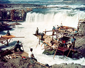