Koblenz
| Koblenz | |
 |
|
| Coat of arms | Location |
 |
 |
| Administration | |
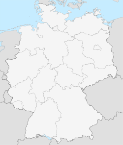
| Country | Germany |
|---|---|
| State | Rhineland-Palatinate |
| District | Urban district |
| Lord Mayor | Eberhard Schulte-Wissermann (SPD) |
| Basic statistics | |
| Area | 105.02 km² (40.5 sq mi) |
| Elevation | 64.7 m (212 ft) |
| Population | 105,888 (30/12/2006) |
| - Density | 1,008 /km² (2,611 /sq mi) |
| Other information | |
| Time zone | CET/CEST (UTC+1/+2) |
| Licence plate | KO |
| Postal codes | 56001–56077 |
| Area code | 0261 |
| Website | www.koblenz.de |
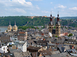
Koblenz (also Coblenz in pre-1926 German spellings; French Coblence) is a city situated on both banks of the Rhine at its confluence with the Moselle, where the Deutsches Eck (German Corner) and its monument (Emperor William I on horseback) are situated.
As Koblenz (Latin (ad) Confluentes, "confluence" or "(at the) merging (rivers)", Covelenz, Cobelenz; local dialect "Kowwelenz") was one of the military posts established by Drusus about 8 BC, the town celebrated its 2000th anniversary in 1992.
After Mainz and Ludwigshafen am Rhein, it is the third largest city in Rhineland-Palatinate, with a population of c. 106,000 (2006). Koblenz lies in the Rhineland, 92 kilometers (57 miles) southeast of Cologne by rail.
Contents |
History
Ancient era
Around 1000 BC, early fortifications were erected on the Festung Ehrenbreitstein hill on the opposite side of the Moselle. In 55 BC Roman troops commanded by Julius Caesar reached the Rhine and built a bridge between Koblenz and Andernach. About 9 BC, the "Castellum apud Confluentes", was one of the military posts established by Drusus.
Remains of a large bridge built in 49 AD by the Romans are still visible. The Romans built two castles as protection of the bridge, one in 9 AD and another in the 2nd century, the latter being destroyed by the Franks in 259. North to Koblenz was a temple of Mercury and Rosmerta (a Gallo-Roman deity), which remained in use up to the 5th century.


Middle Ages
With the fall of the Western Roman Empire, the city was conquered by the Franks and became a royal seat. After the division of Charlemagne's empire, it was included in the lands of his son Louis the Pious (814). In 837 it was assigned to Charles the Bald, and a few years later here Carolingian heirs discussed what was to become the Treaty of Verdun (843), by which the city became part of Lotharingia under Lothair I. In 860 and 922 Koblenz was the scene of ecclesiastical synods. At the former of these, held in the Liebfrauenkirche, took place the reconciliation of Louis the German with his half-brother Charles the Bald. The town was sacked and destroyed by the Normans in 882. Starting from 925, it became part of the eastern German Kingdom, later the Holy Roman Empire.

In 1018 the city, after receiving a charter, was given by the emperor Henry II to the archbishop and prince elector of Trier. It remained in the possession of his seccessors till the close of the 18th century and was their main residence since the 17th century. Emperor Conrad II was elected here in 1138. In 1198 in the nearby took place the battle between Philip of Swabia and Otto IV. In 1216 prince-bishop Theoderich von Wied donated to the Teutonic Knights part of the lands of the basilica and the hospital, which later became the Deutsches Eck.
In 1249-1254 Koblenz was surrounded with new walls by Archbishop Arnold II of Isenburg; and it was partly to overawe the turbulent townsmen that successive archbishops built and strengthened the fortress of Ehrenbreitstein that dominates the city.
Modern era
As a member of the league of the Rhenish cities which took its rise in the 13th century. The Teutonic Knights founded the Bailiwick of Koblenz in or around 1231. Koblenz attained to great prosperity; and it continued to advance till the disasters of the Thirty Years' War occasioned a rapid decline. After Philip Christopher, elector of Trier, had surrendered Ehrenbreitstein to the French the town received an imperial garrison (1632), which was soon, however, expelled by the Swedes. They in their turn handed the city over to the French, but the imperial forces succeeded in retaking it by storm (1636).
In 1688 Koblenz was besieged by the French under Marshal de Boufflers, but they only succeeded in bombing the Old City (Altstadt) into ruins, destroying among other buildings the Old Merchants' Hall (Kaufhaus), which was restored in its present form in 1725. The city was the residence of the archbishop-electors of Trier from 1690 to 1801.
In 1786 the last archbishop-elector of Trier, Clemens Wenceslaus of Saxony, gave great assistance to the extension and improvement of the city, turning the Ehrenbreitstein into a magnificent baroque palace. After the fall of the Bastille in 1789, the city became, through the invitation of the archbishop-elector's chief minister, Ferdinand Freiherr von Duminique, one of the principal rendezvous points for French émigrés. The archbishop-elector approved of this because he was the uncle of the persecuted king of France, Louis XVI. Among the many royalist French refugees who flooded into the city were Louis XVI's two younger brothers, the Comte de Provence and the Comte d'Artois. In addition, Louis XVI's cousin, the Prince de Condé, arrived and formed an army of young aristocrats willing to fight the French Revolution and restore the Ancien Régime. The Army of Condé joined with an allied army of Prussian and Austrian soldiers led by Duke of Brunswick in an unsuccessful invasion of France in 1792. This drew down upon the archbishop-elector the wrath of the First French Republic; in 1794 Coblenz was taken by the French Revolutionary army under Marceau (who fell during the siege), and, after the signing of the Treaty of Lunéville (1801) it was made the capital of the new French départment of Rhin-et-Moselle. In 1814 it was occupied by the Russians. The Congress of Vienna assigned the city to Prussia, and in 1822 it was made the seat of government for the Prussian Rhine Province.
After World War I, France occupied the area once again. In retaliation against the French, the German populace of the city has insisted on using the more German spelling of Koblenz since 1926. Like many other German cities, it was badly mauled in World War II, and rebuilt afterwards. Between 1947 and 1950, it served as the capital of Rhineland-Palatinate.
The Rhine Gorge was declared a World Heritage Site in 2002, with Koblenz marking the northern end.

Main sights
Fortified cities

Its defensive works are extensive, and consist of strong forts crowning the hills encircling the town on the west, and of the citadel of Ehrenbreitstein on the opposite bank of the Rhine. The old city was triangular in shape, two sides being bounded by the Rhine and Mosel and the third by a line of fortifications. The last were razed in 1890, and the town was permitted to expand in this direction. Immediately outside the former walls lies the new central railway station, in which is effected a junction of the Cologne-Mainz railway with the strategic line Metz-Berlin. The Rhine is crossed by a road bridge and, a mile above the town, by a beautiful bridge of two wide and lofty spans carrying the Berlin railway referred to above. The Moselle is spanned by a Gothic freestone bridge of 14 arches, erected in 1344, and also by a railway bridge.
The city, down to 1890, consisted of the Altstadt (old city) and the Neustadt (new city) or Klemenstadt. Of these, the Altstadt is closely built and has only a few fine streets and squares, while the Neustadt possesses numerous broad streets and a handsome frontage to the Rhine.
Other sights
In the more ancient part of Koblenz stand several buildings which have a historical interest. Prominent among these, near the point of confluence of the rivers, is the church of Saint Castor (Kastorkirche), with four towers. The church was originally founded in 836 by Louis the Pious, but the present Romanesque building was completed in 1208, the Gothic vaulted roof dating from 1498. In front of the church of Saint Castor stands a fountain, erected by the French in 1812, with an inscription to commemorate Napoleon's invasion of Russia. Not long after, Russian troops occupied Koblenz; and St. Priest, their commander, added in irony these words: "Vu et approuvé par nous, Commandant russe de la Ville de Coblence: Janvier 1er, 1814."
In this quarter of the town, too, is the Liebfrauenkirche, a fine church (nave 1250, choir 1404-1431) with lofty late Romanesque towers; the castle of the electors of Trier, erected in 1280, which now contains the municipal picture gallery; and the family house of the Metternichs, where Prince Metternich, the Austrian statesman, was born in 1773. Also notable is the church of St. Florian, with a two towers façade from c. 1110.
In the modern part of the town lies the palace (Residenzschloss), with one front looking towards the Rhine, the other into the Neustadt. It was built in 1778-1786 by Clement Wenceslaus, the last elector of Trier, under design by the French architect P.M. d'Ixnard; among other curiosities, it contains some fine Gobelin tapestries. From it some pretty gardens and promenades (Kaiserin Augusta Anlagen) stretch along the bank of the Rhine, and in them is a memorial to the poet Max von Schenkendorf. A fine statue to the empress Augusta, whose favourite residence was Coblenz, stands in the Luisenplatz. But of all public memorials the most striking is the colossal equestrian statue of the emperor William I of Germany, erected by the Rhine provinces in 1897, standing on a lofty and massive pedestal, at the point where the Rhine and Mosel meet.
The former Jesuit College is a Baroque edifice by J.C. Sebastiani (1694-1698) serves as the current Town Hall.
Near Koblenz is the Lahneck Castle near Lahnstein, open to visitors from April 1 to October 31.
The city is close to the Bronze Age earthworks at Goloring, a possible Urnfield calendar constructed some 3000 years ago.
William I Monument
The Teutonic Knights were given an area for their Deutschherrenhaus Balley right at the border of both rivers, which became known as German corner (Deutsches Eck).
In 1897, a monument to German Emperor William I of Germany, mounted on a 14 meter high horse, was inaugurated there by his grandson William II. The architect was Bruno Schmitz, who was responsible for a number of nationalistic German monuments and memorials. The German corner is since associated with this monument, the (re) foundation of the German Empire and the German refusal of any French claims to the area, as described in the song "Die Wacht am Rhein" together with the "Wacht am Rhein" called "Niederwalddenkmal" somewhat 30km upstream.
During World War II, the statue was destroyed by US artillery. The French occupation administration intended the complete destruction of the monument and wanted to replace it with a new one.
In 1953, Bundespräsident Theodor Heuss re-dedicated the monument to German unity, adding the signs of the remaining western federal states as well as the ones of the lost areas in the East. A Flag of Germany waved there since. The Saarland was added four years later after the population had voted to join Germany.
In the 1980s, a movie of the monument was often shown on late night TV when the National Anthem was played to mark the end of the day, a practise which was discontinued when nonstop broadcasting became common. On October 3, 1990, the very day the former GDR states joined, their signs were added to the monument.
As German unity was considered complete and the areas under Polish administration were ceded to Poland, the monument lost its official active purpose, now only reminding of past history. In 1993, the flag was replaced by a copy of the statue, donated by a local couple.
Incorporated villages
Formerly separate villages now incorporated into the jurisdiction of the city of Koblenz
| Date | Village | Area | Date | Village | Area | |
|---|---|---|---|---|---|---|
| 1 July 1891 | Neuendorf mit Lützel | 547 hectares (2.1 sq mi) | 7 June 1969 | Kesselheim | ? | |
| 1 April 1902 | Moselweiß | 382 hectares (1.5 sq mi) | 7 June 1969 | Kapellen-Stolzenfels | ? | |
| 1 October 1923 | Wallersheim | 229 hectares (0.88 sq mi) | 7 November 1970 | Arenberg-Immendorf | ? | |
| 1 July 1937 | Asterstein (Teil von Pfaffendorf) | ? | 7 November 1970 | Arzheim | 487 hectares (1.9 sq mi) | |
| 1 July 1937 | Ehrenbreitstein | 120 hectares (0.46 sq mi) | 7 November 1970 | Bubenheim | ? | |
| 1 July 1937 | Horchheim | 772 hectares (3.0 sq mi) | 7 November 1970 | Güls mit Bisholder | ? | |
| 1 July 1937 | Metternich | 483 hectares (1.9 sq mi) | 7 November 1970 | Lay | ? | |
| 1 July 1937 | Niederberg | 203 hectares (0.78 sq mi) | 7 November 1970 | Rübenach | ? | |
| 1 July 1937 | Pfaffendorf mit Asterstein | 369 hectares (1.4 sq mi) |
Economy
Koblenz is a principal seat of the Mosel and Rhenish wine trade, and also does a large business in the export of mineral waters. Its manufactures include automotive parts (braking systems - TRW Automotive, gas springs and hydraulic vibration dampers - Stabilus), aluminium coils (Aleris Aluminum), pianos, paper, cardboard, machinery, boats and barges. It is an important transit centre for the Rhine railways and for the Rhine navigation.
Twin cities
Koblenz is twinned with the following cities:
 Haringey, London, United Kingdom
 Maastricht, Netherlands
 Nevers, France
- Norwich, United Kingdom
 Novara, Italy
 Petah Tikva (פֶּתַח תִּקְוָה), Israel
 Varaždin, Croatia
The non-profit organisation Sister Cities International.[1] designates
a sister city of Koblenz.
References
- ↑ Sister Cities International (2007). "Online Directory: Germany, Europe". Retrieved October 12, 2007.
External links
- Official website
- Koblenz – Germany’s most beautiful “corner” (English)
- Koblenz City Panoramas - Panoramic views and virtual tours
- Official Town map of Koblenz (needs Java and JavaScript)
- Richard Stillwell, ed. Princeton Encyclopedia of Classical Sites, 1976: "Ad Confluentes (Koblenz), Germany
- Map Location of Ibis Koblenz
- Old postcards of Koblenz
|
||||||||||
|
||||||||