Coast Mountains
| Coast Mountains | |
| Range | |
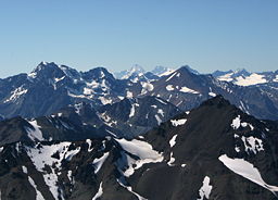 The Coast Mountains, including Mount Waddington (far background, centre) viewed from a distance
|
|
| Countries | Canada, United States |
|---|---|
| Province/States | British Columbia, Alaska, Yukon |
| Part of | Pacific Cordillera |
| Highest point | Mount Waddington |
| - elevation | 4,019 m (13,186 ft) |
| - coordinates | |
The Coast Mountains are a mountain range of the Pacific Cordillera, running along the north western shore of the North American continent, extending south from the Alaska Panhandle and covering most of coastal British Columbia. They are part of a larger grouping, the Pacific Coast Ranges, which includes the Alaska Range, the Chugach Mountains, the Saint Elias Mountains, the Cascade Range, the Sierra Nevada and the Sierra Madre Occidental in Mexico.
The Coast Mountains are approximately 1600 km long and average 200 km in width. Its southern and southeastern boundaries are described by the Fraser River and the Interior Plateau. North of the Nechako Diversion, the Coast Mountains are flanked on the inland side by the Hazelton Mountains, the Skeena Mountains, the Stikine Plateau and the Tahltan and Tagish Highlands. Its far northwestern edge is delimited by the Kelsall River at the north end of the Alaska Panhandle, beyond which are the Saint Elias Mountains.
Covered in dense temperate rainforest on its western exposures, the range rises to heavily glaciated peaks, including the largest temperate-latitude icefields in the world. It then tapers to the dry interior plateau on its eastern flanks, or to the subarctic boreal forest of the Skeena Mountains and Stikine Plateau.
Mount Waddington, at 4,019 metres (13,186 ft), is the highest peak in the Coast Mountains and also the highest peak entirely within British Columbia.
Although the Coast Mountains are commonly considered to be the westernmost range of the Pacific Cordillera, the Insular Mountains are the true westernmost range,[1] which includes Vancouver Island and the Queen Charlotte Islands.
The largest icefield in the Coast Mountains is the Ha-Iltzuk Icefield.
Contents |
Tectonic origin
The Coast Mountains has its origins with a formerly active volcanic arc, called the Coast Range Arc, which began forming about 100 million years ago. Over millions of years, the volcanoes of the Coast Range Arc had their summits worn down and isostatic rebound has caused their solidified magma chambers to rise, forming the Coast Mountains.
During the early to middle Miocene, the Coast Mountains were favored thermally-driven uplift arising from the Miocene passage of the Anahim hotspot beneath the range, and response to convergence in late Miocene-Pliocene time.
Significant peaks

| Mountain/Peak | Height (metres) | Prominence (metres) | Location |
|---|---|---|---|
| Mount Waddington | 4019 | 3289 | |
| Monarch Mountain | 3555 | 2930 | |
| Razorback Mountain | 3183 | 2253 | |
| Skihist Mountain | 2968 | 2463 | |
| Mount Ratz | 3090 | 2430 | |
| Mount Queen Bess | 3298 | 2355 | |
| Wedge Mountain | 2892 | 2249 | |
| Otter Mountain | 2692 | 2242 | |
| Mount Silverthrone | 2860 | 974 | |
| Kwatna Peak | 2290 | 2225 | |
| Scud Peak | 2987 | 2172 |
Subranges
The Coast Mountains are subdivided into numerous mountain ranges:
- Boundary Ranges
- Cheja Range
- Chechidla Range
- Chutine Icefield
- Adam Mountains
- Ashington Range
- Burniston Range
- Dezadeash Range
- Florence Range
- Halleck Range
- Juneau Icefield
- Sawtooth Range
- Kahpo Mountains
- Kakuhan Range
- Lincoln Mountains
- Longview Range
- Peabody Mountains
- Rousseau Range
- Seward Mountains
- Snowslide Range
- Spectrum Range
- Stikine Icecap
- Boundary Range
- Chechidla Range
- Cheja Range
- Kitimat Ranges
- Bare Top Range
- Countess of Dufferin Range
- Kitlope Range
- North Coastal Archipelago
- Bell Range
- Burnaby Range
- Cape Range
- Chismore Range
- Murphy Range
- Richardson Range
- Spiller Range
- Williams Range
- Wimbledon Range
- Tenaiko Range
- Pacific Ranges
- Ashlu-Elaho Divide
- Mount Wood Group
- Bazalgette Range
- Bendor Range
- Bridge-Lillooet Divide
- Railroad Group
- Sampson Group
- Broughton Archipelago
- Calliope Range
- Georgina Range
- Bunster Range
- Cadwallader Range
- Capital Group
- Caren Range
- Charlotte Alplands
- Douglas Ranges
- Clarke Group
- Ratney Group
- Chilcotin Ranges
- Camelsfoot Range
- Dickson Range
- Leckie Range
- Pantheon Range
- Vishnu Group
- Potato Mountains
- Shulaps Range
- Clendinning Range
- Ashlu-Elaho Divide
-
- Colville Range
- Conical Range
- Earle Range
- Edwards Range
- Florence Range
- Franklyn Range
- Fraser Range
- Garibaldi Ranges
- Garibaldi Névé
- Fitzsimmons Range
- Musical Bumps
- Mamquam SW summits
- McBride Range
- Spearhead Range
- Wedge Group
- Golden Ears
- Misty Icefield
- Bastion Range
- Gastineau Range
- Ha-Iltzuk Icefield
- Homathko Icefield
- Koeye Range
- Lewis Range
- Liberated Group
- Lillooet Icefield
- Compton Névé
- Lillooet Ranges
- Breakenridge Group
- Brew-Siwhe Group
- Cantilever Range
- Cayoosh Range
- Joffre Group
- Manatee Group
- Meager Group
- Mission Ridge
- Monarch Icefield
- North Shore Mountains
- Fannin Range
- Britannia Range
- Sky Pilot Group
- Namu Range
- Nicholl Range
- Niut Range
- Pemberton Icefield
- Pembroke Range
- Powell Divide
- Rexford Group
- Sir Harry Range
- Squamish-Cheakamus Divide
- Tantalus Range
- The Tahumming
- Tottenham Range
- Unwin Range
- Waddington Range
- Wharncliffe Range
- Whitemantle Range
References
- ↑ Coast Mountains in the Canadian Mountain Encyclopedia. Retrieved on 2007-10-08
|
||||||||||||||||||||||||||||||||||||||