Clinton County, Illinois
| Clinton County, Illinois | |
| Map | |
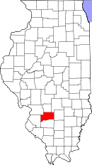
 Location in the state of Illinois |
|
 Illinois's location in the U.S. |
|
| Statistics | |
| Founded | 1824 |
|---|---|
| Seat | Carlyle |
| Area - Total - Land - Water |
503 sq mi (1,303 km²) 474 sq mi (1,228 km²) 29 sq mi (75 km²), 5.81% |
| Population - (2006) - Density |
36,633 77/sq mi (29.8/km²) |
| Website: www.clintonco.illinois.gov | |
Clinton County is a county located in the U.S. state of Illinois, and determined by the U.S. Census Bureau to include the mean center of U.S. population in 1960. Clinton County is part of the St. Louis Metro Area. As of 2006, the population was 36,633. Its county seat is Carlyle, Illinois.
Contents |
History
Clinton County was organized in 1824 out of Washington, Fayette, and Bond Counties. Its name is in honor of the seventh Governor of New York State, DeWitt Clinton, who helped build the Erie Canal.[1]
Geography
According to the U.S. Census Bureau, the county has a total area of 503 square miles (1,304 km²), of which 474 square miles (1,228 km²) is land and 29 square miles (76 km²) (5.81%) is water. Eldon Hazlet State Recreation Area and South Shore State Park are in Clinton County.
Adjacent counties
- Bond County - north
- Fayette County - northeast
- Marion County - east
- Washington County - south
- St. Clair County - west
- Madison County - northwest
Major highways
 Interstate 64
 US Route 50
 Illinois Route 127
 Illinois Route 160
 Illinois Route 161
 Illinois Route 177
Communities
Cities
- Breese
- Carlyle
- Centralia (the larger part, including downtown, is in Marion County)
- Trenton
Villages
|
|
Townships
Clinton County is divided into these fifteen townships:
|
|
|
School districts
- Carlyle Community Unit School District 1
- Patoka Community Unit School District 100
- Sandoval Community Unit School District 501
- Wesclin Community Unit School District 3
Political districts
- Illinois' 19th congressional district
- State House District 102
- State House District 107
- State House District 115
- State Senate District 51
- State Senate District 54
- State Senate District 58
Demographics
| Historical populations | |||
|---|---|---|---|
| Census | Pop. | %± | |
| 1900 | 19,824 |
|
|
| 1910 | 22,832 | 15.2% | |
| 1920 | 22,947 | 0.5% | |
| 1930 | 21,369 | −6.9% | |
| 1940 | 22,912 | 7.2% | |
| 1950 | 22,594 | −1.4% | |
| 1960 | 24,029 | 6.4% | |
| 1970 | 28,315 | 17.8% | |
| 1980 | 32,617 | 15.2% | |
| 1990 | 33,944 | 4.1% | |
| 2000 | 35,535 | 4.7% | |
| Est. 2006 | 36,633 | 3.1% | |
| IL Counties 1900-1990 | |||

As of the census[2] of 2000, there were 35,535 people, 12,754 households, and 9,221 families residing in the county. The population density was 75 people per square mile (29/km²). There were 13,805 housing units at an average density of 29 per square mile (11/km²). The racial makeup of the county was 94.19% White, 3.91% Black or African American, 0.16% Native American, 0.33% Asian, 0.03% Pacific Islander, 0.84% from other races, and 0.54% from two or more races. 1.60% of the population were Hispanic or Latino of any race. 62.1% were of German and 11.0% American ancestry according to Census 2000. 96.8% spoke English, 2.0% Spanish and 1.0% German as their first language.
There were 12,754 households out of which 35.10% had children under the age of 18 living with them, 60.10% were married couples living together, 8.40% had a female householder with no husband present, and 27.70% were non-families. 24.20% of all households were made up of individuals and 11.90% had someone living alone who was 65 years of age or older. The average household size was 2.60 and the average family size was 3.10.
In the county the population was spread out with 24.90% under the age of 18, 9.30% from 18 to 24, 30.20% from 25 to 44, 21.30% from 45 to 64, and 14.40% who were 65 years of age or older. The median age was 37 years. For every 100 females there were 106.60 males. For every 100 females age 18 and over, there were 106.80 males.
The median income for a household in the county was $44,618, and the median income for a family was $52,580. Males had a median income of $36,035 versus $23,506 for females. The per capita income for the county was $19,109. About 4.60% of families and 6.40% of the population were below the poverty line, including 7.80% of those under age 18 and 6.00% of those age 65 or over.
References
- United States Census Bureau 2007 TIGER/Line Shapefiles
- United States Board on Geographic Names (GNIS)
- United States National Atlas
- ↑ Allan H. Keith, Historical Stories: About Greenville and Bond County, IL. Consulted on August 15, 2007.
- ↑ "American FactFinder". United States Census Bureau. Retrieved on 2008-01-31.
External links
|
||||||||||||||||||||||||||
|
||||||||||||||||||||
|
|
||||||||||||||||||||||||||||

