City of Sydney
| City of Sydney New South Wales |
|||||||||||||
 |
|||||||||||||
| Population: | 164,547 (2007) (25th) [1] | ||||||||||||
| • Density: | 6580/km² (17,042.1/sq mi) | ||||||||||||
| Established: | 1842 | ||||||||||||
| Area: | 25 km² (9.7 sq mi) | ||||||||||||
| Mayor: | Lord Mayor Clover Moore (Independent) | ||||||||||||
| Council Seat: | Sydney CBD (Town Hall) | ||||||||||||
| Region: | Metropolitan Sydney | ||||||||||||
| State District: | Sydney, Balmain, Heffron, Marrickville | ||||||||||||
| Federal Division: | Sydney, Wentworth, Kingsford Smith | ||||||||||||
|
|||||||||||||
- South Sydney redirects here. This article is about the local government area. For the NRL team, see South Sydney Rabbitohs.
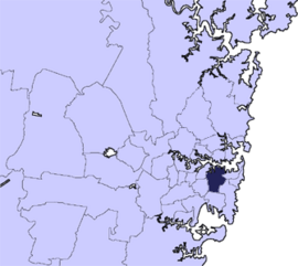
The City of Sydney comprises the Sydney central business district and the surrounding inner west and inner city suburbs of the greater metropolitan area of Sydney, Australia. It is a Local Government Area (LGA), and on 6 February 2004, the former LGA of the City of South Sydney was formally merged into the City of Sydney.
Suburbs within the boundaries of the City of Sydney before the merger include the actual downtown or central business district of Sydney itself, Pyrmont and Ultimo to the west, Haymarket to the south and Woolloomooloo to the east and other suburbs.
Contents |
Geography
The CBD is roughly bounded by Circular Quay and the Harbour to the north, Macquarie Street to the east, the Western Distributor to the west and Liverpool Street to the south. Suburbs within the City of South Sydney before the merger included Alexandria, Darlington (now mostly occupied by the University of Sydney), Erskineville, Newtown, Redfern, Glebe, Waterloo, Paddington.
Demographics
According to the Australian Bureau of Statistics [2], there were:
- 151,920 people as at 30 June 2006, the 13th largest Local Government Area in New South Wales. It was equal to 2.2% of the New South Wales population of 6,827,694
- an increase of 2,934 people over the year to 30 June 2006, the 3rd largest population growth in a Local Government Area in New South Wales. It was equal to 5.0% of the 58,753 increase in the population of New South Wales
- was, in percentage terms, an increase of 2.0% in the number of people over the year to 30 June 2006, the 11th fastest growth in population of a Local Government Area in New South Wales. In New South Wales the population grew by 0.9%
- an increase in population over the 10 years to 30 June 2006 of 45,347 people or 43% (3.6% in annual average terms), the 2nd highest rate of a Local Government Area in New South Wales. In New South Wales the population grew by 622,966 or 10% (1.0% in annual average terms) over the same period.
Suburbs in the local government area

Suburbs within or partially within the City of Sydney are:
|
|
|
Localities in the local government area

Localities in the City of Sydney are:
- Broadway
- Central
- Chinatown
- Circular Quay
- Darling Harbour
- The Domain
- East Sydney
- Goat Island
- Garden Island
- Kings Cross
- Macdonaldtown
- Railway Square
- Strawberry Hills
- Wynyard
History

The name Sydney comes from "Sydney Cove" which is where the English admiral Arthur Phillip established the first settlement, after arriving with the First Fleet. On 22 January 1788, he named it after Thomas Townshend, 1st Viscount Sydney, who was the home secretary at the time, and the man responsible for the plan for the convict colony in Australia.
The "City of Sydney" was established on 20 July 1842[3] by the Corporation Act which encompasses present-day Woolloomooloo, Surry Hills, Chippendale and Pyrmont, an area of 11.65 km². There were six wards established by boundary posts. A boundary post still exists in front of Sydney Square.
The boundaries of the City of Sydney have changed fairly regularly since 1900. The Municipality of Camperdown was merged with the city in 1909. Added in 1949 were Alexandria, Darlington, Erskineville, Newtown, Redfern, Glebe, Waterloo, and Paddington. In 1968 the boundaries were changed and many of these suburbs moved to be part of a new municipality of South Sydney. South Sydney was brought back into the city in 1982, but became separate again under the City of Sydney Act of 1988 and then became smaller than its original size at 6.19 km². It grew again in February, 2004 with the merger of the two council areas, and now has a population of approximately 170,000 people.
The City of Sydney is a major supporter of the Sydney Peace Prize.
Politics
As noted above, the electoral boundary of the City of Sydney have been significantly altered by state governments on at least four occasions since 1945, with advantageous effect to the governing party in the New South Wales Parliament at the time. Successive State governments of both major parties, the Labor Party and the Liberal Party, have re-drawn the electoral boundaries to include inner suburbs that are traditionally supportive of them, and to exclude suburbs that are traditionally hostile.
A 1987 Liberal re-organisation saw Sydney Council split, with southern suburbs forming a new South Sydney council. This was thought to advantage the Liberal government of the day, as the southern suburbs had traditionally voted Labor.
In 2004, the Labor State Government undid this change, again merging the councils of the City of Sydney and the City of South Sydney. Critics claimed that this was performed with the intention of creating a "super-council" which would be under the control of the Australian Labor Party (ALP), which also controlled the State Government. Subsequent to this merger, an election took place on 27 March 2004 which resulted in the independent candidate Clover Moore defeating the high-profile ALP candidate, former federal minister Michael Lee and winning the position of Lord Mayor. Critics of the merger claimed that this was a result of a voter backlash against the party for attempting to create the "super-council".
| Party | 2004-2008 | 2008-2012 | |
| Clover Moore Independent Team | 5 | 6 | |
| Australian Greens | 1 | 2 | |
| Australian Labor Party | 3 | 1 | |
| Liberal Party of Australia | 1 | 1 | |
| Total | 10 | 10 |
Sydney City Council comprises ten councillors, with one Lord Mayor and one Deputy Lord Mayor:
- The Rt. Hon Clover Moore MLA (Lord Mayor)
- Cr. John McInerney
- Cr. Chris Harris (Greens)
- The Hon. Cr. Meredith Burgmann (Labor)
- Cr. Shayne Mallard
- Cr. Marcelle Hoff (Deputy Lord Mayor)
- Cr. Phillip Black
- Cr. Di Tornai
- Cr. Robert Kok
- Cr. Irene Doutney
Sister cities
To encourage sharing of cultural, trade and tourist links, Sydney City Council maintains sister city relations with the following cities:[1]
 Wellington, New Zealand
 Portsmouth, United Kingdom
 Guangzhou, China
 Florence, Italy
In addition, Sydney City Council has partnership agreements with these places:
 Paris, France (partnership city)
 Tokyo, Japan (partnership)
See also
- Coat of arms of Sydney
- List of Mayors and Lord Mayors of Sydney
External links
- Photos of Sydney Australia
- Official website for the City of Sydney
- Boundaries and map of the City of Sydney
- The Sydney Festival
- Sydney Exposed - online photo collection from State Library of NSW
- Late Night and 24 Hour Venues open in Sydney
- Sydney Restaurant Guide
- City of Sydney travel guide from Wikitravel
References
- ↑ Average population working in the CBD 293,000
- ↑ "Regional Population Growth, Australia, 2005-06 (catalogue no.: 3218.0)". Australian Bureau of Statistics. Retrieved on 2007-03-12.
- ↑ "History of Sydney City Council" (pdf). City of Sydney. Retrieved on 2007-02-09.
|
|||||||||||
|
||||||||||||||