Chur
| Chur | ||||||||||
|---|---|---|---|---|---|---|---|---|---|---|
|
||||||||||
| Population | 34,915 (January 2008[update]) | |||||||||
| - Density | 1,247 /km² (3,228 /sq.mi.) | |||||||||
| Area | 28.01 km² (10.8 sq mi) | |||||||||
| Elevation | 593 m (1,946 ft) | |||||||||
| - Highest | 1885 m - Fürhörnli | |||||||||
| - Lowest | 554 m - Bettlerküchen | |||||||||
| Postal code | 7000-7007 | |||||||||
| SFOS number | 3901 | |||||||||
| Mayor (list) | Christian Boner (as of 2008) SVP/UDC | |||||||||
| Localities | Altstadt, Sand, Kasernenquartier, Industriegebiet, Loestrasse-Lürlibad, Masans, Rheinquartier | |||||||||
| Surrounded by (view map) |
Churwalden, Domat/Ems, Felsberg, Haldenstein, Maladers, Malix, Trimmis | |||||||||
| Twin towns | Bad Homburg (Germany), Cabourg (France), Mayrhofen (Austria), Mondorf-les-Bains (Luxembourg), Olathe (USA), Terracina (Italy) | |||||||||
| Website | www.chur.ch | |||||||||
![Chur [zoom] (Switzerland)](/2009-wikipedia_en_wp1-0.7_2009-05/I/265px_Karte_Schweiz.png) Chur [zoom]
|
||||||||||

Chur (German: Chur [kuːr] (in Graubünden), [xuːr] (elsewhere); Romansh Cuira [ˈkwera] or [ˈkwojra]; Italian Coira [ˈkɔjra]); French: Coire; Latin: Curia, Curia Rhaetorum and Curia Raetorum) is the capital of the Swiss canton of Graubünden and lies in the northern part of the canton.
Contents |
History
The city of Chur is the seat of the bishops of Chur and capital of the Swiss canton of Graubünden, in which Chur is the most populous municipality. Archaeological evidence of settlement at the site goes back as far as the Pfyn culture (3900-3500 BCE), making Chur one of the oldest settlements in Switzerland. The city is located at a highly strategic location, where the roads from several major Alpine transit routes come together and pass together down the Rhine river towards various destinations in Switzerland and Germany.
The modern name Chur derives from when the site was a Roman fortified camp, Curia Raetorum in Latin. Later in the Roman period, Chur became the capital of the Roman province of Rhaetia Prima in 15 BC. It was of moderate importance, being mentioned in the Antonine Itineraries and Paul the Deacon's Historia Langobardorum (History of the Lombards), vi. 21.
During the period of the Republic of the Three Leagues in Graubünden (ca. 1400-1797), Chur was the chief town of the Gotteshausbund or Chadé (League of the House of God), and one of the places the Leagues' assemblies met regularly.
The bishopric still existed in the early 20th century, with jurisdiction over the cantons of the Graubünden, Glarus, Zurich, and the three Forest Cantons (Uri, Schwyz, Unterwalden, and Lucerne), as well as the sovereign Principality of Liechtenstein. The guild constitution of the city of Chur lasted from 1465 to 1839, while in 1874 the Burgergemeinde was replaced by an Einwohnergemeinde.
When Graubünden became a canton in 1803, Chur was chosen as its capital.
Ecclesiastical history and prince-bishopric
The modern Diocese of Chur comprises the Swiss cantons of Graubünden, Glarus, Zürich, Unterwalden, and Uri. The sovereign Principality of Lichtenstein was a deanery within the Diocese until 1997, when it was separated from Chur by Papal decree and became the independent Archdiocese of Vaduz/Liechtenstein, with Wolfgang Haas, former Bishop of Chur and a native of Liechtenstein, as the first Archbishop.
A Bishop of Chur is first mentioned in 451/ 452 when its Bishop St. Asimo attended the Synod of Milan (Mansi, IV, 141), but the bishopric probably existed a century earlier. The bishopric, originally in the ecclesiastical province of Milan, later transferred to Mainz in 843 CE. Its territory in the medieval and early modern periods included the Val Venosta with a secondary center in Merano (now in Italy), the Vorarlberg (now in Austria), and the valley of the Linth river as far as the southern end of the Lake of Zurich.
The Bishops were also important secular rulers in the region from the seventh until fifteenth century, and their lordship provided the framework for the emergence of the Gotteshausbund or Chadé (League of the House of God), one of the three leagues of communities that formed the Republic of the Three Leagues in Graubünden after about 1450 CE. In the two sets of Ilanz Articles (1524 and 1526), the Republic of the Three Leagues rejected political control by the bishops, although later bishops rejected the Articles and sought to reassert their political powers. In the early modern period, the bishops also remained princes of the Holy Roman Empire, although they rarely attended the Imperial Diet. During the Protestant Reformation, considerable parts of the see's German, Romansh, and Italian speaking population adopted the Swiss Reformed faith, although many also remained Catholic, especially in the Val Venosta.
The appointment in 1990 of Bishop Wolfgang Haas, seen by a considerable number of Catholics in the see as following conservative positions at the wish of Pope John Paul II, caused considerable dissent in the see for several years, until his appointment as first Archbishop of Liechtenstein in 1997.
Several holy and extraordinary men have contributed to the splendour of the Diocese of Chur. Four of its bishops are honoured as saints: St. Asimo (c. 450), St. Valentinian (530-48), St. Ursicinus (d. 760), and St. Adalbert (1151-60). Fidelis von Sigmaringen, a Capuchin priest sent to convert the local Protestant population during a period of Austrian military occupation in 1621, was martyred in the see, in the village of Seewis, in 1622.
According to the Kirchliches Handlexicon (Munich, 1906) the diocese had a Catholic population of about 248,887 (non-Catholics, 431,367).
Description
Chur is built, at a height of 1949 ft. above the sea-level, on the right bank of the Plessur torrent, just as it issues from the Schanfigg valley, and about a mile above its junction with the Rhine, almost entirely surrounded by the Alps, overshadowed by the Mittenberg (east) and Pizokel (south), hills that guard the entrance to the deep-cut Schanfigg valley.
Chur has 33,500 inhabitants; languages spoken include Swiss German, Italian and Romansh. In 1900 of its 11,532 inhabitants, 9288 were German-speaking, 1466 Romansch-speaking, and 677 Italian-speaking; while 7561 were Protestants, 3962 Roman Catholics.
It has a variable altitude in the city area from just 600 metres above sea level to 1,800 metres above sea level, while the Churer Hausberg Brambrüesch (accessible from the Old Town) is situated at 2,174 metres above sea level.
The water of Chur's spring is exported and sold as Passugger mineral water.
Sights

The modern part of the city is to the west, but the old portion, with all the historical buildings, is to the east. Here is the cathedral church of St Luzius (who is the patron of Coire, and is supposed to be a 2nd-century British king Lucius, though really the name has probably arisen from a confusion between Lucius of Cyrene, miswritten curiensis, with the Roman general Lucius Munatius Plancus, who conquered Raetia).
Built between 1178 and 1282, on the site of an older church, it contains many curious medieval antiquities (especially in the sacristy), as well as a picture by Angelica Kauffmann, and the tomb of the great Grisons political leader (d. 1637) Jenatsch. Opposite is the Bishops Palace, and not far off, is the Episcopal Seminary (built on the ruins of a 6th-century monastic foundation). Not far from these ancient monuments is the new Raetian Museum, which contains a great collection of objects relating to Raetia (including the geological collections of the Benedictine monk of Disentis Abbey, Placidus a Spescha (1752-1833), who explored the high snowy regions around the sources of the Rhine). One of the hospitals was founded by the famous Capuchin philanthropist, Father Theodosius Florentini (1808-1865), who was long the Romanist cur of Coire, and whose remains were in 1906 transferred from the cathedral here to Ingenbohl (near Schwyz), his chief foundation. The Romano-Gothic cathedral where lie the remains of Jörg Jenatsch was begun by Bishop Tello (758-73), has a highly interesting crypt; it contains remarkable paintings by Dürer and Holbein.
In this town you may also visit the Giger Bar designed by the Swiss artist H. R. Giger, the Old Town, the art gallery, and the natural museum.
Transportation
Chur is 74 km by rail from Zurich, and is the meeting-point of the routes from Italy over many alpine passes (Lukmanier Pass, Splugen Pass, and San Bernardino Pass), as well as from the Engadine (Albula Pass, Julier Pass), so that it is the centre of an active trade (particularly in wine from the Valtelline), though it also has a few local factories.
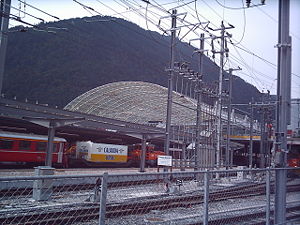
The railway station has the SBB-CFF-FFS lines link with the RhB (Rhaetian railways) lines. While the SBB lines serve most of Switzerland, most of Graubünden's rail traffic is served by Rhaetian state railways. One of the lines uses on-street running down the main street to reach the station.
There is also a bus station on top of the railway station.
Chur is linked by a motorway—the A13.
See also
- Bishop of Chur for the list of incumbents
- Mario Frick - Liechtensteiner football player, born in Chur.
- H. R. Giger - Artist born in Chur.
- Carl Hilty - philosopher and lawyer born in Chur
- Angelica Kauffmann - Artist born in Chur
- Johanna Spyri
- List of mayors of Chur
Sources and References
- Chur (municipality) in Romansh, German, French and Italian in the online Historical Dictionary of Switzerland.
- This article incorporates text from the Encyclopædia Britannica Eleventh Edition, a publication now in the public domain. as Coire
- A. Eichhorn, Episcopatus Curiensis (St Blasien, 1797)
- W. von Juvalt, Forschungen fiber die Feudalzeit im Curischen Raetien, 2 parts (Zurich, 1871)
- C. Kind, Die Reformation in den Bistumern Chur und Como (Coire, 1858)
- Conradin von Moor, Geschichte von Curraetien (2 vols., Coire, 1870-1874)
- P. C. you Planta, Des alte Raetien (Berlin, 1872); Idem, Die Curraetischen Herrschaften in der Feudalzeit (Bern, 188i); Idem, Verfassungsgeschichte der Stadt Cur im Mittelalter (Coire, 1879); Idem, Geschichte von Graubünden (Bern, 1892).
- This article incorporates text from the public-domain Catholic Encyclopedia of 1913.
- Principality of Liechtenstein homepage on religion
External links
- City of Chur - official website (German)
- Chur tourism office (German)
- Chur tourism office - English
|
|||||||
|
|||||