Chiba Prefecture
| Chiba Prefecture | |||||||||
|
|||||||||
 |
|||||||||
| Capital | Chiba | ||||||||
| Region | Kantō | ||||||||
| Island | Honshū | ||||||||
| Governor | Akiko Dōmoto | ||||||||
| Area (rank) | 5,156.15 km² (27th) | ||||||||
| - % water | 0.8% | ||||||||
| Population (2000) | |||||||||
| - Population | 6,006,185 (6th) | ||||||||
| - Density | 1,165 /km² | ||||||||
| Districts | 6 | ||||||||
| Municipalities | 56 | ||||||||
| ISO 3166-2 | JP-12 | ||||||||
| Website | http://www.pref.chiba.lg.jp/ english/index.html |
||||||||
| Prefectural Symbols | |||||||||
| - Flower | Rape blossom | ||||||||
| - Tree | Kusamaki | ||||||||
| - Bird | Meadow Bunting | ||||||||
Symbol of Chiba Prefecture |
|||||||||
| Template ■ Discussion ■ Parameter ■ WikiProject Japan | |||||||||
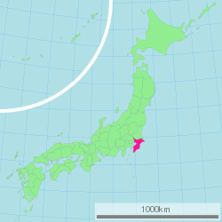
Chiba Prefecture (千葉県 Chiba-ken?) is a prefecture of Japan located in the Greater Tokyo Area. Its capital is Chiba City.
Contents |
History
Chiba Prefecture was established on June 15, 1873 with the merger of Kisarazu Prefecture and Inba Prefecture. Historically, the prefecture constituted three provinces of Awa, Kazusa, and Shimousa.
Geography
Chiba borders Ibaraki Prefecture to the north at the Tone River, Tokyo and Saitama Prefecture to the west at the Edo River, the Pacific Ocean to the east and Tokyo Bay around its southern boundary. Most of Chiba lies on the hilly Boso Peninsula, a rice farming region: the east coast, known as the Ninety-Nine League Plain, is an especially productive area. The most populous zone, in the northwest of the prefecture, is part of the Kantō region that extends into the urban agglomeration of Tokyo and Saitama. The Kuroshio Current flows near Chiba, which keep it relatively warm in winter and cooler in summer than neighbouring Tokyo.
Cities
Thirty-six cities are located in Chiba Prefecture:
|
|
|
‡ Scheduled to be dissolved after mergers.
Towns and villages


These are the towns and villages in each district:
|
|
|
Mergers
Economy
Chiba is one of Japan's largest industrial areas, thanks to its long coastline on Tokyo Bay. After Chiba was chosen as the site for a major Kawasaki Steel factory in 1950, the prefectural government embarked on a large-scale land reclamation program that dredged up large plots of waterfront property for factories, warehouses, and docks. Chemical production, petrochemical refining, and machine production are the three main industries in Chiba today: together, they account for forty-five percent of the prefecture's exports. In recent years, the government has funded more than eighty industrial parks to bring development further inland as well.
The prefecture also boasts Japan's second-highest agricultural output: among all the prefectures, only Hokkaidō produces more agricultural products, and Chiba leads Hokkaidō in vegetable production. Seaweed is harvested in large quantities from Tokyo Bay.
Demographics
Chiba's population is one of the wealthiest in Japan due to the prefecture's strong commercial and industrial sectors. Per capita GDP is ¥3.1 million, the fifth-highest in the country. 70% of the population is employed in the service sector, with 25% in industry and 5% in agriculture.
Education
Chiba Prefectural Board of Education oversees municipal school districts in the prefecture; the board also directly operates public high schools in the prefecture.
Culture
Chiba in popular culture
- Novels set in Chiba include: Neuromancer by William Gibson (set in Chiba city), Ningen Shikkaku by Osamu Dazai (Funabashi), and Nogiku no Haka by Sachio Itō (Matsudo).
- Manga (comics) representations include: Be Free!, Chameleon, Kyō Kara Ore wa!!, Makuhari (set in Chiba city), Makuhari Saboten Campus (Chiba city), Susume!! Pirates, and Urayasu Tekkin Kazoku (Urayasu).
- Anime (animation) representations include: Chikyū Bōei Kazoku (set in Funabashi), Battle Programmer Shirase (Narashino), and Zegapain (Urayasu).
- TV series representations include: Kisarazu Cat's Eye (set in Kisarazu), Mio Tsukushi (Chōshi), Beach Boys (filmed in Tateyama and Shirahama (now Minamiboso) and Yappari Neko ga Suki (Chiba city).
- Various rock bands have roots that stem from the Chiba prefecture, including the popular X Japan, Plastic Tree, girugamesh and punk bands like Nicotine and Ellegarden.
- Tanaka Koki, Rapper of KAT-TUN, is from Chiba Prefecture.
Sports
The following sports teams are based in Chiba.
Football (soccer)
- JEF United Ichihara Chiba (Chiba, Ichihara)
- Kashiwa Reysol (Kashiwa)
- JEF United Ichihara Chiba Amateur (Ichihara)
Baseball
- Chiba Lotte Marines
Rugby
- IBM Big Blue (Yachiyo)
- Kubota Spears (Funabashi)
- NEC Green Rockets (Abiko)
Transportation
Most Tokyo-bound visitors arriving on international flights land in Narita International Airport, which is situated in Narita in the north of the prefecture, and connected to Tokyo by the East Japan Railway's Narita Express and the Keisei Electric Railway's Skyliner.
Railway
- East Japan Railway Company
- Sōbu Main Line
- Chūō-Sōbu Line
- Sōbu Line (Rapid)
- Jōban Line
- Jōban Line (Local)
- Jōban Line (Rapid)
- Narita Line
- Uchibō Line
- Sotobō Line
- Keiyō Line
- Musashino Line
- Tōgane Line
- Kashima Line
- Kururi Line
- Sōbu Main Line
Tourism
The Tokyo Disney Resort is located in Urayasu near the western border of the prefecture.
Chiba is linked to Tokyo by several railway lines: the main trunk lines are the Keiyo Line and Sobu Line. The Musashino Line connects Chiba to Saitama and northern Tokyo. Southern Chiba is connected to Kanagawa Prefecture by the Tokyo Bay Aqua-Line bridge-tunnel.
Prefectural symbols
Chiba is famous for peanuts. Most of Japan's peanuts are harvested in this prefecture and are also processed into peanut oil.
External links
- Official Chiba Prefecture website (English)
- Chiba Information Guide (English)
|
||||||||||||||||||||||||||
|
|||||||||||