Chernivtsi Oblast
| Chernivtsi Oblast Чернівецька область Chernivets’ka oblast’ |
|||||
|
|||||
| Nickname: Буковина (Ukrainian) Bukovyna (transliteration) |
|||||
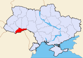 Location of Chernivtsi Oblast (red) on the map of Ukraine (blue). |
|||||
| Official language(s) | Ukrainian | ||||
| Administrative center | Chernivtsi | ||||
| Largest cities | Chernivtsi, Novodnistrovsk | ||||
| Governor | Volodymyr Kulish (OU) | ||||
| Oblast council | |||||
| – Chairman | Ivan Shylepnytskyi (FP) | ||||
| – № of seats | 104 | ||||
| Established | August 9, 1940 | ||||
| Subdivisions | |||||
| – Raions | 11 | ||||
| – Cities of oblast subordinance | 2 | ||||
| – Cities (total) | 11 | ||||
| – Towns | 8 | ||||
| – Villages | 398 | ||||
| Area | Ranked 25th | ||||
| – Total | 8,097 km² | ||||
| – Land | ? km² | ||||
| – Water | ? (?%) | ||||
| Population | Ranked 26th | ||||
| – Total (2006) | 904,423 | ||||
| – Density | 113 p/ km² | ||||
| – Average salary | UAH 785 (?%) | ||||
| Time zone | EET +2 | ||||
| – Summer (DST) | EEST +3 | ||||
| Abbreviations | |||||
| – Postal code | 58-60xxx | ||||
| – ISO 3166-2 | UA-77 | ||||
| – FIPS 10-4 | UP03 | ||||
| – Telephone code | +380-37 | ||||
| – Licence plate | |||||
| Official website | www.oda.cv.ua | ||||
| Verkhovna Rada site | www.rada.gov.ua | ||||

Chernivtsi Oblast (Ukrainian: Чернівецька область, translit. Chernivets’ka oblast’), is an oblast (province) in western Ukraine, bordering on Romania and Moldova. It has a large variety of landforms: the Carpathian Mountains and picturesque hills at the foot of the mountains gradually change to a broad partly forested plain situated between the Dniester and Prut rivers. Its capital is the city Chernivtsi. The region has a population (as of 2004-05-01) of 913,275 and spans 8,100 km².
Contents |
Geography
Chernivtsi Oblast is covering the area of 8,097 km². This is the smallest oblast in Ukraine, representing 1.3% of Ukrainian territory.
In the oblast there are 75 rivers longer than 10 kilometers. The largest rivers are Dnister (290 km), Prut (128 km) and Siret (113 km).[1]
The oblast is located in three geograpic zones: forest steppe region between Prut and Dnister rivers, foothill region between Carpathian Mountains and Prut river, and mountain region know as Bukovinian part of Carpathian Mountains.[1]
Chernivtsi Oblast is bordered by Ivano-Frankivsk Oblast, Ternopil Oblast, Khmelnytskyi Oblast, Vinnytsia Oblast, Romania, and Moldova. Within the oblast, the state border of Ukraine with Romania is 226 km, and with Moldova is 198 km.[1]
Attractions
- Khotyn Fortress State historical-architectural preserve
- Bukovynian Mytropolyt residency
- Kozmodemyanivska church
History
Chernivtsi oblast was created on August 7, 1940 in the wake of the Soviet occupation of Bessarabia and Northern Bukovina. The oblast was organized out of the northeast part of Ţinutul Suceava of Kingdom of Romania, joining parts of three historical regions: northern half of Bukovina, northern half of the Hotin County county of Bessarabia, and Hertza region, which was part of the Dorohoi county (presently Botoşani County) of proper Moldavia.
Human settlements in the region date back thousands years, when the Cucuteni culture flourished in the area. In the Middle Ages, the region was part of the Principality of Moldavia, which in the late middle age became a vassal of the Ottoman Empire. In 1775, two counties of Moldavia, since then known as Bukovina, were annexed by the Habsburg Monarchy, which later became Austrian Empire. In 1812, one half of Moldavia, since then known as Bessarabia, was annexed by the Russian Empire. Hertza region remained in Moldavia until its union with Wallachia in 1859, a union which in 1866 became the Kingdom of Romania. In 1918 both provinces of Bukovina and Bessarabia united with the Kingdom of Romania.
The Soviet occupation started on June 28, 1940. In addition to Bessarabia, they demanded northern Bukovina as compensation of the belongings of Bessarabia to Romania from 1918 to 1940. Hertza region was not included in the ultimatum notes that the Soviet Union addressed to Romania, but was occupied at the same time. Most of the occupied territories were organized on August 2, 1940 as Moldavian Soviet Socialist Republic, while the remainder, including the Chenivtsi Oblast, formed on August 7, 1940, were included in the Ukrainian Soviet Socialist Republic.

Throughout 1940-1941 several tens of thousands of Bukovinians were deported to Siberia and Kazakhstan, of which some 13,000 alone on June 13, 1941. This and later deportations were primarily based on social class difference, it targeted intellectuals, people employed previously by the state, businessmen, clergymen, students, railworkers. The majority of those targeted were ethnic Romanians, but there were many representatives of other ethnicities, as well. The protests of the Romanian population of Bukovina that found themselves under the Soviet rule brought about serious Soviet reprisals, including of ethnic character. In the winter and spring of 1941, the Soviet troops (NKVD) opened fire on many groups of locals trying to cross the border into Romania (for more, see: Fântâna Albă massacre).
Between September 17 and November 17, 1940, by a mutual agreement between USSR and Germany, 43,641 "ethnic Germans" from the Chernivtsi region were moved to Germany, although the total ethnic German population was only 34,500, and of these some 3,500 did not go to Germany. Upon their arrival in Germany, the Nazi government sent most of non-ethnic Germans to concentration camps. Only some of them were freed after the protests of the Romanian government.
During World War II, when the region returned under the control of the Romanian, the Jewish community of the area was largely destroyed by the deportations to ghettos and concentration camps, where about 60% died. Despite the anti-Semitic policies of the Ion Antonescu's government of Romania, the mayor of Cernăuţi, Traian Popovici, now honored by Israel's Yad Vashem memorial as one of the Righteous Among the Nations, saved ca. 20,000 Jews.
In 1944, when the Soviet troops returned to Bukovina, many inhabitants fled to Romania, and Soviet persecutions resumed, with the result that the region was seriously depopulated. In demographic terms, these war-time and post-war-time factors changed the region's ethnic composition. Today the number of Jews, Germans and Poles is statistically insignificant, while the number of Romanians has decreased substantially.
Ruthenian communities in Bukovina date back to at least 16th century. In 1775, Ukrainians (Ruthenians) represented some 8,000 out of a 75,000 population of Bukovina. By 1918, as a result of immigration of Ukrainian peasants from nearby villages in Galicia and Podolia, there were over 200,000 Ukrainians, out of a total of 730,000. Most of Ukrainians settled in the northern parts of Bukovina. Their number was especially large in the area between the Dniester and Prut rivers, where they became a majority. A similar process occurred in northern Bessarabia. Throughout the history of the region, there were no interethnic clashes, while the city of Chernivtsi was renouned for its German-style architecture, for a highly cultivated society, and for ethnic tolerance. Small ethnic disputes were however present on occasion. In 1918, many Ukrainians in Bukovina wanted to join an independent Ukrainian state. After an initial period of free education in Ukrainian language, in late 1920s Romanian authorities attempted to switch all education to the Romanian language. In 1940-1941, the Soviet reprisals were more massive in the parts of the Chernivsti oblast were Romanians predominated, however when after 1944 Ukrainian anti-Soviet resistance rose up, Romanians and Ukrainians fought alongside against NKVD.
Many Ukrainians in the south-western mountain area of the Chernivtsi region belong to the Hutsul ethnic sub-group, a sophisticated cultural community inhabiting an area in the Carpathian Mountains in both Ukraine and Romania.
When the Soviet Union broke down, Chernivtsi Oblast, then part of the Ukrainian SSR, became part of the newly independent (August 24, 1991) Ukraine. It has a Ukrainian ethnic majority. In the referendum on December 1, 1991, 92% of Chernivtsi Oblast residents supported the independence of Ukraine, a wide support from both Ukrainians and Romanians.
Subdivisions of Chernivtsi Oblast
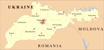
The Chernivtsi Oblast consists of 11 raions, as well as 2 cities directly subordinated to the oblast:
- Raions:
- Hertsaivskyi Raion (Ukrainian: Герцаївський район, translit. Hertsayivs'kyi raion)
- Hlybotskyi Raion (Ukrainian: Глибоцький район, translit. Hlybots'kyi raion)
- Kelmenetskyi Raion (Ukrainian: Кельменецький район, translit. Kel'menets'kyi raion)
- Khotynskyi Raion (Ukrainian: Хотинський район, translit. Khotyns'kyi raion)
- Kitsmanskyi Raion (Ukrainian: Кіцманський район, translit. Kitsmans'kyi raion)
- Novoselytskyi Raion (Ukrainian: Новоселицький район, translit. Novoselyts'kyi raion)
- Putylskyi Raion (Ukrainian: Путильський район, translit. Putyl's'kyi raion)
- Sokyrianskyi Raion (Ukrainian: Сокирянський район, translit. Sokyryans'kyi raion)
- Storozhynetskyi Raion (Ukrainian: Сторожинецький район, translit. Storozhynets'kyi raion)
- Vyzhnytskyi Raion (Ukrainian: Вижницький район, translit. Vyzhnyts'kyi raion)
- Zastavnivskyi Raion (Ukrainian: Заставнівський район, translit. Zastavnivs'kyi raion)
- Cities:
- Chernivtsi (Ukrainian: Чернівці), the administrative center of the oblast
- Novodnistrovsk (Ukrainian: Новодністровськ, translit. Novodnistrovs'k)
Population and Demographics

According to the latest Ukrainian Census (2001),[2] Ukrainians represent about 75% (689.1 thousands) of the population of Chernivtsi Oblast. 12.5% (114.6 thousands) reported themselves as Romanians, 7.3% (67.2 thousand) as Moldavians, and 4.1% (37.9 thousands) as Russians. The other nationalities, such as Poles, Belarusians, and Jews sum up to 1.2%.
The separate categories for the Moldovans and Romanians as two etnicities has been criticized by Romanian organizations in Ukraine.[3] However, all census respondents had to write in their ethnicity (no predetermined set of choices existed), and could respond or not to any particular census question, or not answer any questions at all.[4] Also, no allegation of counting fraud were brought up. However, Interregional Union, one of Romanian communities in Ukraine criticized what they see as the continuous usage of Romanians and Moldovans as two separate ethnic groups.
According to the Romanian census of 1930, the territory of the future Chernivtsi Oblast had 805,642 inhabitants in that year, out of which 47.6% were Ukrainians, and 28.2% were Romanians. The rest of the population was 88,772 Jews, 46,946 Russians (among them an important community of Lipovans), around 35,000 Germans, 10,000 Poles, and 10,000 Hungarians.[3]
During the inter-war period, Cernăuţi county had a population of 306,975, of which 136,380 were Ukrainians, and 78,589 were Romanians. Storojineţ County had 77,382 Ukrainians and 57,595 Romanians. (The three other counties of Bukovina, which remained in Romania, had a total of 22,368 Ukrainians). The northern part of the Hotin County had approximately 70% Ukrainians and 25% Romanians. Herţa region, smaller by area and population, was virtually 100% Romanian.
Major demographic changes occurred during the Second World War. Immediate after the Soviet takeover of the region in 1940 the Soviet government deported or killed about 41,000 Romanians (see Fântâna Albă massacre), while at the same time further encouraging an influx of Ukrainians from the Ukrainian SSR. Most Poles were deported by the Soviet authorities, while most Germans forcibly returned to Germany. After the Kingdom of Romania took control of the region during the war (1941-1944), the Jewish community of the area was largely destroyed by the deportations to ghettos and concentration camps.
The languages of the population closely reflect the ethnic composition with over 90% within each of the major ethnic groups declaring their national language as the mother tongue.
| Raions/Cities | Total | Ukrainians | Russians | Romanians | Moldovans | Other |
|---|---|---|---|---|---|---|
| Hertsaivskyi Raion | 32,316 | 1,616 | 299 | 29,554 | 756 | 91 |
| Hlybotskyi Raion | 72,676 | 34,025 | 877 | 32,923 | 4,425 | 426 |
| Kelmenetskyi Raion | 48,468 | 47,261 | 607 | 25 | 477 | 98 |
| Khotynskyi Raion | 72,398 | 66,060 | 927 | 59 | 5,102 | 250 |
| Kitsmanskyi Raion | 72,884 | 71,805 | 674 | 116 | 88 | 201 |
| Novoselytskyi Raion | 87,461 | 29,703 | 1,235 | 5,904 | 50,329 | 290 |
| Putylskyi Raion | 25,352 | 25,182 | 98 | 19 | 20 | 33 |
| Sokyryanskyi Raion | 48,889 | 43,927 | 3,044 | 43 | 1,681 | 194 |
| Storozhynetskyi Raion | 95,295 | 56,786 | 1,367 | 35,095 | 307 | 1,740 |
| Vyzhnytskyi Raion | 59,993 | 58,924 | 631 | 196 | 58 | 184 |
| Zastavnivskyi Raion | 56,261 | 55,733 | 335 | 38 | 55 | 100 |
| city of Chernivtsi | 236,691 | 189,021 | 26,733 | 10,553 | 3,829 | 6,555 |
| city of Novodnistrovsk | 10,344 | 9,013 | 1,054 | 30 | 98 | 149 |
| Total | 919,028 | 689,056 | 37,881 | 114,555 | 67,225 | 10,311 |
References
- ↑ 1.0 1.1 1.2 About Oblast Chernivtsi Oblast State Administration (Ukrainian)
- ↑ 2001 Ukrainian Census | English version | Results | General results of the census | National composition of population | Chernivtsi region
- ↑ 3.0 3.1 Noi,NU! Revistă de atitudine şi cultură - Românii din Ucraina (Romanian)
- ↑ The Organization Order of the Population Census at the State Statistics Committee of Ukraine web-site.
- ↑ 2001 Census results Statistics Committee of Chernivtsi Oblast
External links
- Chernivtsi Oblast Administration (official website) (Ukrainian)
- Chernivtsi Oblast Council (official website) (Ukrainian)
- Statistics Committee of Chernivtsi Oblast (Ukrainian)
See also
|
||||||||||||||||||||
|
|||||||||||||||||