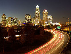
Charlotte, North Carolina
| City of Charlotte | |||
 |
|||
|
|||
| Nickname(s): "The Queen City", "The QC", "The Hornet's Nest" | |||
 |
|||
| Coordinates: | |||
| Country | |||
|---|---|---|---|
| State | |||
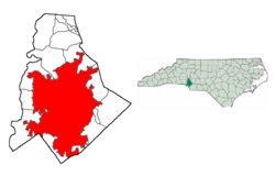
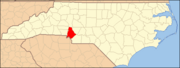
| County | Mecklenburg County | ||
| Government | |||
| - Mayor | Pat McCrory, (R) | ||
| Area | |||
| - City | 280.5 sq mi (629.0 km²) | ||
| - Land | 279.9 sq mi (627.5 km²) | ||
| - Water | 0.6 sq mi (1.6 km²) | ||
| Elevation | 751 ft (229 m) | ||
| Population (2007)[1] | |||
| - City | 671,588 (19th) | ||
| - Density | 2,515.7/sq mi (971.3/km²) | ||
| - Urban | 758,927 | ||
| - Metro | 2,491,650 | ||
| Time zone | EST (UTC-5) | ||
| - Summer (DST) | EDT (UTC-4) | ||
| Area code(s) | 704, 980 | ||
| FIPS code | 37-12000[2] | ||
| GNIS feature ID | 1019610[3] | ||
| Website: http://www.charmeck.org/ | |||
Charlotte (pronounced /ˈʃɑrlət/) is the largest city in the state of North Carolina and the seat of Mecklenburg County. As the 19th-largest city in the United States, Charlotte is also the largest city on the Eastern Seaboard between Philadelphia and Jacksonville. In 2007, Charlotte's population was estimated to be 671,588.[1] A resident of Charlotte is referred to as a Charlottean.
Nicknamed the Queen City, Charlotte (as well as the county containing it) is named in honor of the German Princess Charlotte of Mecklenburg, who had become queen consort of British King George III the year before the city's founding. A second nickname derives from later in the 18th century. During the American Revolutionary War, British commander General Cornwallis occupied the city but was driven out soon afterwards by hostile residents, prompting him to write that Charlotte was "a hornet's nest of rebellion," leading to another city nickname: The Hornet's Nest. This is also reason for the City's former NBA team the Charlotte Hornets.
In 2008, the Charlotte metropolitan area had an estimated population of 1,675,495 . The Charlotte metropolitan area is part of a wider thirteen-county labor market region or combined statistical area that has an estimated population (as of 2008) of 2,491,650.[4] In 2008, Charlotte was chosen the "Best Place to Live in America" by relocate-america.com in its annual ranking, based on factors including employment opportunities, crime rates, and housing affordability.[5] It was also named #8 of the 100 "Best Places to Live and Launch" by CNNMoney.com - cities picked for their vibrant lifestyles and opportunities for new businesses.[6]
Contents |
History

The area that is now Charlotte was first settled in 1755 when Thomas Polk (uncle of United States President James K. Polk), who was traveling with Thomas Spratt and his family, stopped and built his house of residence at the intersection of two Native American trading paths between the Yadkin and Catawba rivers.[7] One of the paths ran north-south and was part of the Great Wagon Road; the second path ran east-west along what is now modern-day Trade Street. In the early part of the 18th century, the Great Wagon Road led settlers of Scots-Irish and German descent from Pennsylvania into the Carolina foothills. Within the first decades following Polk's settling, the area grew to become the community of "Charlotte Town," which officially incorporated as a town in 1768.[8] The crossroads, perched atop a long rise in the Piedmont landscape, became the heart of modern Uptown Charlotte.
In 1770, surveyors marked off the new town's streets in a grid pattern for future development. The east-west trading path became Trade Street, and the Great Wagon Road became Tryon Street, in honor of William Tryon, a royal governor of colonial North Carolina.[9] The intersection of Trade and Tryon is known as "Trade & Tryon" or simply "The Square."[7] It is more properly called Independence Square.[10]
Both the town (now a city) and its county are named for Charlotte of Mecklenburg-Strelitz, the German-born wife of British King George III. The town name was chosen in hopes of winning favor with the crown,[11] but tensions between the United Kingdom and Charlotte Town began to grow as King George imposed unpopular laws on the citizens in response to the townspeople's desire for independence.[12] On May 20, 1775, the townsmen allegedly signed a proclamation later known as the Mecklenburg Declaration of Independence, a copy of which was sent, though never officially presented, to the Continental Congress a year later.[13] The date of the declaration appears on the North Carolina state flag. Eleven days later, the same townsmen met to create and endorse the Mecklenburg Resolves, a set of laws to govern the newly independent town.[14]
Charlotte was a site of encampment for both American and British armies during the Revolutionary War and, during a series of skirmishes between British troops and Charlotteans, the village earned the lasting nickname "Hornet's Nest" from frustrated Lord General Charles Cornwallis.[15] An ideological hotbed of revolutionary sentiment during the Revolutionary War and for some time afterwards, the legacy endures today in the nomenclature of such landmarks as Independence Boulevard, Independence High School, Independence Center, Freedom Park, Freedom Drive, and the former NBA team Charlotte Hornets.
Churches, mainly of the Presbyterian faith, but also Baptists, Methodists, Episcopalians, Lutherans, and Catholics, began to form in the early 1800s, eventually giving Charlotte its nickname "The City of Churches."[16]
In 1799, in nearby Cabarrus County, 12-year-old Conrad Reed brought home a rock he found in Little Meadow Creek, weighing about 17 pounds, which the family used as a bulky doorstop. Three years later, a jeweler determined that it was near solid gold, and bought it for a paltry $3.50.[17] The first verified gold find in the fledgling United States, young Reed's discovery became the genesis of the nation's first gold rush. Many veins of gold were found in the area throughout the 1800s and even into the early 1900s, thus the founding of the Charlotte Mint in 1837 for minting local gold. The state of North Carolina "led the nation in gold production until the California Gold Rush of 1848,"[18] although the total volume of gold mined in the Charlotte area was dwarfed by subsequent rushes. Charlotte's city population at the 1880 Census grew to 7,084.[19] Some locally based groups still pan for gold occasionally in local (mostly rural) streams and creeks. The Reed Gold Mine operated until 1912. The Charlotte Mint was active until 1861, when Confederate forces seized the mint at the outbreak of the Civil War. The mint was not reopened at the end of the war, but the building survives today, albeit in a different location, now housing the Mint Museum of Art.
The city's first boom came after the Civil War, as a cotton processing center and a railroad hub. Population leapt again during World War I, when the U.S. government established Camp Greene north of present-day Wilkinson Boulevard. Many soldiers and suppliers stayed after the war, launching an ascent that eventually overtook older and more established rivals along the arc of the Carolina Piedmont.[20]
The city's modern-day banking industry achieved prominence in the 1970s and 1980s, largely under the leadership of financier Hugh McColl. McColl transformed North Carolina National Bank (NCNB) into a formidable national player that, through a series of aggressive acquisitions, eventually became Bank of America. Another bank, First Union, experienced similar growth, and is now known as Wachovia after a merger. Today, measured by control of assets, Charlotte is the second largest banking headquarters in the United States after New York City.[21]
In 1989, the city took a direct hit from Hurricane Hugo. Passing through Charlotte as a Category 1 hurricane with wind gusts over 100 mph (160 km/h) in some locations, Hugo caused massive property damage and knocked out electrical power to 98% of the population. Many residents were without power for several weeks and cleanup took months to complete. The city is just over 200 miles inland, and many residents from coastal areas in both Carolinas often wait out hurricanes in Charlotte. The city was caught unprepared, as almost no one expected a storm to strike with hurricane force this far inland. Over 80,000 trees were destroyed in Charlotte.
In December 2002, Charlotte (and much of central North Carolina) was hit by a massive ice storm (which some dubbed, "Hugo on Ice") that knocked out power to over 1.2 million Duke Energy customers. According to a Duke Energy representative: "This ice storm surpasses the damage from Hurricane Hugo in 1989, which had 696,000 outages." During an abnormally cold December, many were without power for more than two weeks. Much of the damage was caused by Bradford pear trees which, still having leaves on December 4, split apart under the weight of the ice.
Geography and climate
According to the United States Census Bureau, the city has a total area of 242.9 square miles (629 square kilometers). Out of that, 242.3 sq. mi. (627.5 km²) of it is land and 0.6 sq. mi. (1.6 km²) of it is water. The total area is 0.25% water.
Charlotte constitutes most of Mecklenburg County in the Carolina Piedmont. Uptown/downtown Charlotte sits atop a long rise between two creeks and was built on the gunnies of the St. Catherine's and Rudisill gold mines. There is much disagreement about the use of the interchangeable terms "Uptown" and "Downtown" for the center city area. Prior to the late 1980s, the term "Downtown" was always used as a reference for Charlotte's center city area and many area residents still use the "Downtown" term. On February 14, 1987, the Charlotte Observer began calling the center city area "Uptown" in order to help promote a positive image of the area.[22]
Charlotte's elevation is 748 feet above sea level (at Charlotte/Douglas International Airport).
A 2007 American Lung Association report[23] ranks Charlotte as having the 16th highest levels of smog among U.S. cities; however, the region's air quality has improved significantly in recent years, and is expected to continue to do so, even with increasing travel.[24]
Charlotte is located in North America's humid subtropical climate zone. On average it receives 44 inches of rain and 4 inches of snow per year. The city has cool winters and warm, humid summers. In January, morning lows average around 0 °C (32 °F) and afternoon highs average 11 °C (51 °F). In July, lows average 22 °C (71 °F) and highs average 32 °C (90 °F). The highest recorded temperature was 40 °C (104 °F) on September 6, 1954 and during the August 2007 Southeastern heat wave.[25] The lowest recorded temperature was -21 °C (-5 °F) in January 1985. Charlotte's location puts it in the direct path of subtropical moisture from the Gulf as it heads up the eastern seaboard along the jet stream, thus the city receives ample precipitation throughout the year but also a very large number of clear, sunny, and pleasantly warm days. On average, Charlotte receives about 1105.3 mm (43.52 in) of precipitation annually, including very little snow and more frequent ice-storms.
| Month | Jan | Feb | Mar | Apr | May | Jun | Jul | Aug | Sep | Oct | Nov | Dec | Year |
|---|---|---|---|---|---|---|---|---|---|---|---|---|---|
| Avg high [°F](°C) | 51 (11) | 56 (13) | 64 (18) | 73 (23) | 80 (27) | 87 (31) | 90 (32) | 88 (31) | 82 (28) | 73 (23) | 63 (17) | 54 (12) | 72 (22) |
| Avg low temperature [°F](°C) | 32 (0) | 34 (1) | 42 (6) | 49 (9) | 58 (14) | 66 (19) | 71 (22) | 69 (21) | 63 (17) | 51 (16) | 42 (6) | 35 (2) | 51 (11) |
| Rainfall (inches)(millimeters) | 4.00 (101.6) | 3.55 (90.2) | 4.39 (111.5) | 2.95 (74.9) | 2.66 (93) | 3.42 (86.9) | 3.79 (96.3) | 3.72 (94.5) | 3.83 (97.3) | 3.66 (93) | 3.36 (85.3) | 3.18 (80.8) | 43.52 (1105.3) |
Cityscape

Spanning Uptown to Ballantyne, Charlotte has 199 neighborhoods. In the next few years, downtown will undergo a massive construction phase with buildings from Bank of America, Wachovia and multiple condos. Elizabeth Avenue will also be under construction for a shopping center and residence buildings.
Economy
Charlotte has become a major U.S. financial center, and, based on assets, both the nation's largest and third largest financial institutions call the city home (Bank of America and Wachovia, respectively). Bank of America' headquarters, along with other regional banking and financial services companies, are located primarily in the uptown financial district. Thanks in large part to the expansion of the city's banking industry, the Charlotte skyline has mushroomed in the past two decades and boasts the Bank of America Corporate Center, the tallest skyscraper between Philadelphia and Atlanta. The 60-story postmodern gothic tower, designed by renowned architect Cesar Pelli, stands 871 feet tall and was completed in 1992.
The following Fortune 500 companies are headquartered in the Charlotte metropolitan area, in order of their rank: Bank of America, Wachovia , Lowe's in suburban Mooresville, Nucor (steel producer), Duke Energy, Sonic Automotive, Family Dollar, Goodrich Corporation, and SPX Corporation (industrial technology). Other major companies headquartered in the Metro Charlotte include Time Warner Cable (a business unit of Fortune 500 company Time Warner), Continental Tire North America (formerly Continental/General Tire), Muzak, Belk, Harris Teeter, Meineke Car Care Centers, Lance, Inc, Bojangles', Carlisle Companies, LendingTree, Compass Group USA, Food Lion, and the Carolina Beverage Corporation (makers of Cheerwine, Sun Drop, and others) in suburban Salisbury. Also, neighboring Gastonia is home to the Parkdale Mills world headquarters.
Charlotte is also a major center in the US motorsports industry, with NASCAR having multiple offices in and around Charlotte. Approximately 75% of the NASCAR industry's employees and drivers are based within two hours of downtown Charlotte. Charlotte is also the future home of the NASCAR Hall of Fame, expected to be completed in 2009. The already large presence of the racing technology industry along with the newly built NHRA premier dragstip, zMAX Dragway at Concord which is located just north of Charlotte in Concord, NC, is influencing some of the top professional drag racers to move their shops from more expensive areas like California to the Charlotte area as well.
The center city/uptown area of Charlotte has seen remarkable growth over the last decade. Numerous residential units continue to be built uptown, including over 20 skyscapers either under construction, recently completed, or in the planning stage. Many new restaurants, bars and clubs now operate in the Uptown area. Several projects are transforming the Midtown Charlotte/Elizabeth area.
Law, government and politics
Charlotte has a council-manager form of government. The mayor and city council are elected every two years, with no term limits. The mayor is ex officio chairman of the city council, and only votes in case of a tie. Unlike other mayors in council-manager systems, Charlotte's mayor has the power to veto ordinances passed by the council; vetoes can be overridden by a two-thirds majority of the council. The council appoints a city manager to serve as chief administrative officer.
Unlike other cities and towns in North Carolina, elections are held on a partisan basis. The current mayor of Charlotte is Pat McCrory, of the Republican Party. McCrory has served as mayor since his election in 1995. Charlotte holds elections for mayor every two years, with the next election in 2009.
Although it has elected Republican mayors since 1987, Charlotte tends to lean Democratic. However, voters are friendly to moderates of both parties. Republican strength is concentrated in the southeastern portion of the city, while Democratic strength is concentrated in the south-central, eastern and northern areas.
The city council comprises 11 members (7 from districts and 4 at-large). The Democrats currently control the council with an advantage of 7-to-4. While the city council is responsible for passing ordinances, many policy decisions must be approved by the North Carolina General Assembly as well, since North Carolina municipalities do not have home rule. Since the 1960s, however, municipal powers have been broadly construed.
Charlotte is split between three congressional districts on the federal level--the 8th, represented by Republican Robin Hayes; the 9th, represented by Republican Sue Myrick; and the 12th, represented by Democrat Mel Watt.
The Charlotte-Mecklenburg Police Department (CMPD) is a combined jurisdiction agency. The CMPD has law enforcement jurisdiction in both the City of Charlotte and the unincorporated areas of the County of Mecklenburg; however, several smaller towns, such as Matthews, maintain their own law enforcement agencies for their own jurisdictions. The Department consists of approximately 1600 sworn, armed, law enforcement officers, and several hundred civilian support personnel. The Charlotte-Mecklenburg Police Department divides the city into 13 geographic areas, which vary in size both geographically and by the number of officers assigned to each division.
- See also: List of mayors of Charlotte, North Carolina, Charlotte mayoral election, 2007, and List of city council members in Charlotte
Education and Libraries
School System
The city's public school system, Charlotte-Mecklenburg Schools, is the second largest in North Carolina and 20th largest in the nation.[26] About 132,000 students are taught in 161 separate elementary, middle and high schools. Secular and religious private schools are prominent, from well-established schools with large campuses to others that are small and new. The relatively recent phenomenon of charter schools, independently operated public schools, are another education option.
Colleges and Universities

Charlotte's largest higher education institution, the University of North Carolina at Charlotte, is located in University City, as the northeastern portion of Charlotte is called. At 23,000 students and counting, it is the fastest-growing university in the state system and the fourth largest. The area is also home to University Research Park, a 3,200 acre (13 km²) research and corporate park. Central Piedmont Community College has multiple campuses, all in the Charlotte metro area, and is the largest community college in North Carolina or South Carolina.[27] Charlotte is home to a number of notable private universities and colleges such as Johnson & Wales University, Queens University of Charlotte, Johnson C. Smith University, a separate branch of Pfeiffer University, and a nationally ranked liberal arts college, Davidson College; the latter being 20 miles north of Charlotte. Belmont Abbey College is located across the Catawba River in neighboring Gaston County
In fall 2006 the city was excited to have its first law school, the Charlotte School of Law, open its doors. The school recently moved into a new state-of-the-art facility just outside the west side of uptown in the historic Bryant Park district.
- See also: List of schools in Charlotte
Libraries
Public Library of Charlotte and Mecklenburg County

The Public Library of Charlotte and Mecklenburg County serves the Charlotte area with a large collection (over 1.5 million) of books, CDs and DVDs at 19 locations in the city of Charlotte. There are also branches in the surrounding townships of Matthews, Mint Hill, Huntersville, Cornelius and Davidson. All locations provide free access to Internet-enabled computers and WiFi and a library card from one location is accepted at all 24 locations.
Although the Library's roots go back to the Charlotte Literary and Library Association, founded on January 16 1891,[28] the state-chartered Carnegie Library which opened on the current North Tryon site of the Main Library was the first non-subscription library opened to members of the public in the city of Charlotte. The philanthropist Andrew Carnegie donated $25,000 dollars for a library building on the condition that the city of Charlotte donate a site, and $2500 per year for books and salaries,[29] and that the state grant a charter for the library. All conditions were met, and the Charlotte Carnegie Library opened in a imposing classical building on July 2, 1903.
The 1903 state charter also required that a library be opened for the disenfranchised African-American population of Charlotte. This was completed in 1905, with opening of the Brevard Street Library for Negroes, an independent library [30] in Brooklyn, a historically black area of the city of Charlotte, on the corner of Brevard and East Second Street (now Martin Luther King Blvd.) The Brevard Street Library was the first library for free blacks in the state of North Carolina, [31] some sources say in the southeast. [32] This library was closed in 1961 when the Brooklyn neighborhood in Second Ward was redeveloped, but its role as a cultural center for African-Americans in Charlotte is continued by the Beatties Ford branch, the West branch and the Belmont Center branch of the current library system, as well as by Charlotte's African-American Cultural Center.
Billy Graham Library
Charlotte is also home to the Billy Graham Library, an independent library which opened to the public on June 5, 2007, and chronicles the life and ministry of Christian evangelist Billy Graham.
People and culture
Demographics
| Historical populations[33][34][35] | |
|---|---|
| Census year |
Population |
|
|
|
| 1880 | 7,094 |
| 1890 | 12,000 |
| 1900 | 19,000 |
| 1910 | 34,000 |
| 1920 | 70,983[36] |
| 1930 | 85,864[36] |
| 1940 | 100,899 |
| 1950 | 134,042 |
| 1960 | 201,564 |
| 1970 | 241,178 |
| 1980 | 315,473 |
| 1990 | 395,934 |
| 2000 | 540,828 |
As of 2006, census estimates show there are 671,588 people living within Charlotte's city limits, and 1,027,445 in Mecklenburg County. The Combined Statistical Area of Charlotte-Gastonia-Concord, NC-SC had a population of 2,891,604 in 2006 Figures from the more comprehensive 2000 census show Charlotte's population density to be 861.9/km² (2,232.4/sq mi). There are 230,434 housing units at an average density of 951.2/sq mi (367.2/km²).[37][38]
Estimates for 2006 conclude that the city's breakdown by race is as follows:
- 54.7% Caucasian - mainly English, Irish, German, Scots-Irish, and Italian ancestry[39]
- 34.4% African American
- 11.0% Hispanic or Latino of any race
- 4.1% Asian - mainly of Indian, Chinese, and Vietnamese ancestry
- 0.5% Native American
- 0.0% Pacific Islander
- 4.4% from other races
- 1.7% from two or more races.
- 49.5% from Non-Hispanic white.
The median income for a household in the city is $48,670, and the median income for a family is $59,452. Males have a median income of $38,767 versus $29,218 for females. The per capita income for the city is $29,825. 10.6% of the population and 7.8% of families are below the poverty line. Out of the total population, 13.8% of those under the age of 18 and 9.7% of those 65 and older are living below the poverty line.
Religion

The birthplace of Billy Graham, Charlotte was and still is locally known as the "The City of Churches." Of those who practice a religion, most Charlotteans are Christians of various Protestant denominations. Throughout much of its history Presbyterian churches were the most prominent in Charlotte (Charlotte is the historic seat of Southern Presbyterianism), but the changing demographics of the city's rapidly increasing population have brought scores of new denominations and faiths to the city. The Billy Graham Evangelistic Association, Wycliffe Bible Translators' JAARS Center, and SIM Missions Organization also make their homes in Charlotte. In total, Charlotte proper lays claim to more than 700 places of worship.
The Baptist Peace Fellowship of North America is headquartered in Charlotte, and both Reformed Theological Seminary and Gordon-Conwell Theological Seminary have campuses there; more recently, the Religious Studies academic departments of Charlotte's local colleges and universities have also grown considerably.
Charlotte is the seat of the bishop of the Roman Catholic Diocese of Charlotte. The largest Christian congregation within Charlotte is that of St. Matthew Catholic Church. The Traditional Latin Mass is offered by the Society of St. Pius X at St. Anthony Catholic Church in nearby Mount Holly.
The African Methodist Episcopal Zion Church (AME Zion) is headquartered in Charlotte.
Jewish synagogues (Temple Beth El and the Lake Norman Jewish Congregation:[40] Reform Judaism, Temple Israel: Conservative Judaism, Ohr HaTorah: Lubavitch, Havurat Tikvah: Reconstructionist Judaism, Temple Or Olam:[41] Nondenominational Judaism, and a Charlotte Torah Center congregation) are located in or adjacent to Shalom Park on Providence Road.[42] In recent decades, Judaism has thrived in Charlotte and the Carolinas,[43][44] with local Jews such as Leon Levine and Herman Blumenthal making huge charitable and philanthropic contributions to the city and surrounding regions.[45]

The Sikh Community meets on Sundays and all important Sikh religious days at the local Gurdwara Sahib. Gurdwara Charlotte[46] is known for its modern design while still following the spirit of the traditional styling inside.
Nichiren Shu Buddhists meet at Myosho-ji, Wonderful Voice Buddhist Temple
There are also several other religious institutions in the Charlotte area, including two Unitarian Universalist Churches and the Eidolon Foundation.[47]
The Salvation Army's headquarters for the North and South Carolina Division is located in Charlotte, as well as many local corps community centers and Boy's and Girl's Clubs.
Media
Sports
| Club | Sport | Founded | League | Venue |
|---|---|---|---|---|
| Charlotte Knights | Baseball | 1976 | International League | Knights Stadium, Fort Mill, SC |
| Carolina Panthers | Football | 1995 | National Football League | Bank of America Stadium |
| Charlotte Checkers | Ice hockey | 1993 | ECHL | Time Warner Cable Arena |
| Charlotte Eagles | Soccer | 1993 | USL-2 | Waddell Stadium |
| Charlotte Lady Eagles | Soccer | 1993 | W-League | Waddell Stadium |
| Charlotte Bobcats | Basketball | 2004 | National Basketball Association | Time Warner Cable Arena |
| Carolina Speed | Indoor football | 2006 | American Indoor Football Association | Cabarrus Arena & Events Center |
| Charlotte Rugby Football Club | Rugby union | 1989 | Rugby Super League | Skillbeck Athletic Grounds |
| Charlotte Roller Girls | Flat Track Roller Derby | 2006 | Women's Flat Track Derby Association | Cricket Arena |
Transportation
Mass transit
- See also: LYNX Rapid Transit Services

The Charlotte Area Transit System (CATS) is the agency responsible for operating mass transit in Charlotte, and Mecklenburg County.
CATS operates light rail transit, historical trolleys, express shuttles, and bus service serving Charlotte and its immediate suburbs. The LYNX light rail system comprises a 9.6-mile line north-south line known as the Blue Line. Bus ridership continues to grow (66% since 1998), but more slowly than operations increases which have risen 170% in that same time when adjusted for inflation.[48] The 2030 Transit Corridor System Plan looks to supplement established bus service with light rail & commuter rail lines as a part of a system dubbed LYNX.

Roads and Highways

Charlotte's central location between the population centers of the northeast and southeast has made it a transportation focal point and primary distribution center, with two major interstate highways, I-85 and I-77, intersecting near the city's center. Charlotte's beltway, designated I-485 and simply called "485" by locals, is partially completed but stalled for funding. The new projection has it slated for completion by 2013.[49] Upon completion, 485 will have a total circumference of approximately 67 miles (108 km). Within the city, the I-277 loop freeway encircles Charlotte's downtown (usually referred to by its two separate sections, the John Belk Freeway and the Brookshire Freeway) while Charlotte Route 4 links major roads in a loop between I-277 and I-485.
Air

Charlotte/Douglas International Airport is the 30th busiest airport in the world, as measured by traffic[50] It is served by many domestic airlines, as well as international airlines Air Canada and Lufthansa, and is the largest hub of US Airways. Nonstop flights are available to many destinations across the United States, as well as flights to Canada, Central America, the Caribbean, Europe, and Mexico.
Intercity rail
Charlotte is served daily by three Amtrak routes.
The Crescent train connects Charlotte with New York, Philadelphia, Baltimore, Washington, Charlottesville, and Greensboro to the north, and Atlanta, Birmingham and New Orleans to the south.
The Carolinian train connects Charlotte with New York, Philadelphia, Baltimore, Washington, Richmond, Raleigh, Durham and Greensboro.
The Piedmont train connects Charlotte with Raleigh, Durham and Greensboro.
The Amtrak station is located at 1914 North Tryon Street.
The city is currently building a new centralized multimodial train station called the Gateway Station. It is expected to house the future LYNX Purple Line, the new Greyhound bus station, and the Crescent line that passes through Uptown Charlotte.
Sister cities
Charlotte has seven sister cities:[51]
 Arequipa, Peru (1962)
 Baoding, People's Republic of China (1987)
 Krefeld, Germany (1985)
 Kumasi, Ghana (1995)
 Limoges, France (1992)
 Voronezh, Russia (1991)
 Wrocław, Poland (1993)
See also
- Financial Centre
- Charlotte metropolitan area
- Hurricane Hugo
- I-85 Corridor
- Mecklenburg County
- List of people from Charlotte
- Piedmont Crescent
- May 1989 tornado outbreak
Wedding Photography
References
- ↑ 1.0 1.1 "Annual Estimates of the Population for Incorporated Places Over 100,000, Ranked by July 1, 2006 Population". Retrieved on 2008-04-10.
- ↑ "American FactFinder". United States Census Bureau. Retrieved on 2008-01-31.
- ↑ "US Board on Geographic Names". United States Geological Survey (2007-10-25). Retrieved on 2008-01-31.
- ↑ Charlotte Chamber - Population Estimates 2008
- ↑ Charlotte-Named-Best-Place-to-Live: Personal Finance News from Yahoo! Finance
- ↑ [1]
- ↑ 7.0 7.1 "The Charlotte-Mecklenburg Story: History Timeline: Founding a New City". cmstory.org Web Site. Public Library of Charlotte and Mecklenburg County. Retrieved on 2008-10-25.
- ↑ Mecklenburg County, North Carolina USGenWeb Project
- ↑ "The Charlotte-Mecklenburg Story: History Timeline: Designing a New City". cmstory.org Web Site. Public Library of Charlotte and Mecklenburg County. Retrieved on 2008-10-25.
- ↑ "101 Independence Center". Retrieved on 2008-10-15.
- ↑ "The Charlotte-Mecklenburg Story: History Timeline: Charlotte Incorporated". cmstory.org Web Site. Public Library of Charlotte and Mecklenburg County. Retrieved on 2008-10-25.
- ↑ "The Charlotte-Mecklenburg Story: History Timeline: King's Power". cmstory.org Web Site. Public Library of Charlotte and Mecklenburg County. Retrieved on 2008-10-25.
- ↑ The Charlotte-Mecklenburg Story: History Timeline: Mecklenburg Declaration
- ↑ "The Charlotte-Mecklenburg Story: History Timeline: Mecklenburg Resolves". cmstory.org Web Site. Public Library of Charlotte and Mecklenburg County. Retrieved on 2008-10-25.
- ↑ "The Charlotte-Mecklenburg Story: History Timeline: Revolutionary War". cmstory.org Web Site. Public Library of Charlotte and Mecklenburg County. Retrieved on 2008-10-25.
- ↑ "The Charlotte-Mecklenburg Story: History Timeline: The City of Churches". cmstory.org Web Site. Public Library of Charlotte and Mecklenburg County. Retrieved on 2008-10-25.
- ↑ Blanchard Online: American Rarities (Retrieved on 05-22-07)
- ↑ The Charlotte Branch Mint
- ↑ "The Charlotte-Mecklenburg Story". cmstory.org Web Site. Public Library of Charlotte and Mecklenburg County. Retrieved on 2008-10-25.
- ↑ "The Charlotte-Mecklenburg Story: History Timeline: Antebellum Days". cmstory.org Web Site. Public Library of Charlotte and Mecklenburg County. Retrieved on 2008-10-25.
- ↑ "The Charlotte-Mecklenburg Story: History Timeline: 80s Charlotte". cmstory.org Web Site. Public Library of Charlotte and Mecklenburg County. Retrieved on 2008-10-25.
- ↑ "The Charlotte-Mecklenburg Story: History Timeline: 'Down' becomes 'Up'". cmstory.org Web Site. Public Library of Charlotte and Mecklenburg County. Retrieved on 2008-10-25.
- ↑ American Lung Association, Annual Air Quality Report Card (2007)
- ↑ "Charlotte: Regional Trends" 2. 2007 John Locke Foundation. Retrieved on 2007-10-18.
- ↑ Weather History
- ↑ http://media.newsobserver.com/content/news/education/wake/story_graphics/20071012_wschools.jpg Media.newsobserver.com
- ↑ CHLT - Colleges
- ↑ "Public Library of Charlotte and Mecklenburg County: A century of service". cmstory.org Web Site. Public Library of Charlotte and Mecklenburg County. Retrieved on 2008-10-25.
- ↑ "Public Library of Charlotte and Mecklenburg County: A century of service". cmstory.org Web Site. Public Library of Charlotte and Mecklenburg County. Retrieved on 2008-10-25.
- ↑ "Public Library of Charlotte and Mecklenburg County: A century of service". cmstory.org Web Site. Public Library of Charlotte and Mecklenburg County. Retrieved on 2008-10-25.
- ↑ "Public Library of Charlotte and Mecklenburg County: A century of service". cmstory.org Web Site. Public Library of Charlotte and Mecklenburg County. Retrieved on 2008-10-25.
- ↑ "charmeck.org Web Site". Retrieved on 2008-10-25.
- ↑ Gibson, Campbell (June 1998). "Population of the 100 Largest Cities and Other Urban Places in the United States: 1790 to 1990". U.S. Bureau of the Census - Population Division. Retrieved on 2008-10-25.
- ↑ "Hornet's Nest: The story of Charlotte and Mecklenburg County". cmstory.org Web Site. Public Library of Charlotte and Mecklenburg County. Retrieved on 2008-10-25.
- ↑ "US POPULATION HISTORY FROM 1850: 50 LARGEST CITIES".
- ↑ 36.0 36.1 Charlotte does not appear in the largest 100 cities prior to 1940. Figure is inferred from 100th ranking in this year.
- ↑ "Mecklenburg County MapStats from FedStats". US Census Bureau. Retrieved on 2008-04-10. "Population of Census records circa 2006"
- ↑ "Charlotte city, North Carolina - ACS Demographic and Housing Estimates: 2006". US Census Bureau. Retrieved on 2008-04-10. "Charlotte Demographics and Population circa 2006"
- ↑ http://www.city-data.com/city/Charlotte-North-Carolina.html City-data.com
- ↑ www.lakenormanjc.org
- ↑ www.or-olam.org
- ↑ Community Directory
- ↑ Charlotte
- ↑ Charlotte History
- ↑ Home Page
- ↑ Gurdwara Charlotte
- ↑ Eidolon Foundation - Home
- ↑ http://www.charlotte.com/transit/story/242097.html
- ↑ News 14 | 24 Hour Local News | TOP STORIES
- ↑ http://www.aci.aero/cda/aci/display/main/aci_content.jsp?zn=aci&cp=1-5-54-57_9_2__
- ↑ Charlotte's Sister Cities
Further reading
- Hanchett, Thomas W. Sorting Out the New South City: Race, Class, and Urban Development in Charlotte, 1875-1975. 380 pages. University of North Carolina Press. August 1, 1998. ISBN 0-8078-2376-7.
- Kratt, Mary Norton. Charlotte: Spirit of the New South. 293 pages. John F. Blair, Publisher. September 1, 1992. ISBN 0-89587-095-9.
- Kratt, Mary Norton and Mary Manning Boyer. Remembering Charlotte: Postcards from a New South City, 1905-1950. 176 pages. University of North Carolina Press. October 1, 2000. ISBN 0-8078-4871-9.
- Kratt, Mary Norton. New South Women: Twentieth Century Women of Charlotte, North Carolina. Public Library of Charlotte and Mecklenburg County in Association with John F. Blair, Publisher. August 1, 2001. ISBN 0-89587-250-
External links
- Official Charlotte-Mecklenburg County NC website
- Charlotte Area Transit System (CATS)
- The Charlotte-Mecklenburg Story a local history website
- Charlotte travel guide from Wikitravel
- Charlotte's social homepage
Maps and aerial photos
- Charlotte, North Carolina is at coordinates
|
||||||||||||||||||||||||||
|
|||||||||||||||||||

|

|
|||||||||||
|
|||||||||||||||||