Charing Cross
| Charing Cross | |
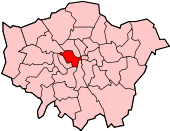
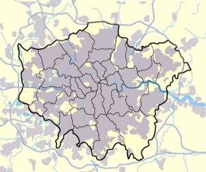 Charing Cross shown within Greater London |
|
| OS grid reference | |
|---|---|
| London borough | Westminster |
| Ceremonial county | Greater London |
| Region | London |
| Constituent country | England |
| Sovereign state | United Kingdom |
| Post town | LONDON |
| Postcode district | WC2 |
| Dialling code | 020 |
| Police | Metropolitan |
| Fire | London |
| Ambulance | London |
| European Parliament | London |
| UK Parliament | Cities of London and Westminster |
| London Assembly | West Central |
| List of places: UK • England • London | |
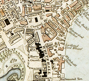
Charing Cross is located at the junction of the Strand, Whitehall and Cockspur Street in Central London, England. The name originates from the Eleanor cross put there 1291-4 by King Edward I as a memorial to his wife, Eleanor of Castile at the former hamlet of Charing. Since 1675 the site of the cross has been occupied by a statue of King Charles I mounted on a horse. That original position of the cross is recognised by modern convention[1] as the centre of London for the purpose of indicating distances by road in favour of other previous measurement points (such as St. Paul's Cathedral which remains as the root of the English and Welsh part of the Great Britain road numbering scheme). Charing Cross is marked on contemporary maps as a road junction, though it was previously also a postal address denoting the stretch of road between Great Scotland Yard and Trafalgar Square. Since 1 January 1931 this section of road has been designated as part of the Whitehall thoroughfare.[2]
Contents |
History
A famous inn called the "Golden Cross" - first mentioned in 1643 - was situated in the former village of Charing. From here, in the eighteenth and nineteenth centuries, coaches departed by various routes to Dover, Brighton, Bath, Bristol, Cambridge, Holyhead and York. The inn features in Sketches by Boz, David Copperfield and The Pickwick Papers by Charles Dickens. In the latter, the dangers to public safety of the low archway between the inn to the street were pointed out by Mr Jingle in a somewhat memorable fashion:
"Heads, heads - take care of your heads", cried the loquacious stranger as they came out under the low archway which in those days formed the entrance to the coachyard. "Terrible place - dangerous work - other day - five children - mother - tall lady, eating sandwiches - forgot the arch - crash - knock - children look round - mother's head off - sandwich in her hand - no mouth to put it in - head of family off"
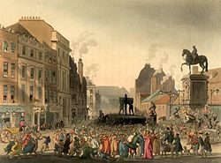
The inn has since been demolished and its fame, which apparently once spread "from the Pillars of Hercules to the Ganges, from Nova Zembla to New Zealand, and from Siam to California", is no more.[3] A prominent Pillory, where malefactors were publicly flogged, was situated next to the statue of King Charles.[4] To the north of Charing Cross was the King's Mews, a royal stable. This whole area was transformed when Trafalgar Square was built on the site in 1832.
Official use as central point
Legislation from the early 19th century used Charing Cross as a central point for defining its scope. Its later use in legislation waned in favour of providing a schedule of local government areas and became mostly obsolete with the official creation of Greater London in 1965.
Charing Cross arches


Since the railway was built, the arches beneath Charing Cross railway station have provided refuge for some of London's marginal groups, wary of a hostile public reaction to their way of life. In the early twentieth century, the arches and Charing Cross station concourse were notorious cruising sites.[5] They also provided shelter for many of London's single homeless people drifting between hostels and the streets and sleeping rough in cardboard boxes.[6][7]
The Charing Cross arches were the inspiration for the popular song "Underneath the Arches" performed by the famous duo Bud Flanagan and Chesney Allen. They were also the focal point for the influential radio documentary Underneath the Arches (named after the song), which alerted public attention to the plight of homeless people.[8]
| Use | Scope |
|---|---|
| Metropolitan Police District | The Metropolitan Police Act 1829 made provision that all parishes within 12 miles could be added. This was expanded to 15 miles by the Metropolitan Police Act 1839. |
| Metropolitan Buildings Office | The London Building Act 1844 allowed that any place within 12 miles could be added to the area of responsibility. |
| The Knowledge | Streets within a six-mile radius are included in taxi driver training. |
Nearest places
- Trafalgar Square
- Soho
- Holborn
- Mayfair
- Bloomsbury ]
Nearest tube stations
- Charing Cross tube station
- Embankment tube station
- Leicester Square tube station
- Waterloo station
- Westminster tube station
Nearest railway stations
References
- ↑ There is an absence of official definition in the UK Statute Law Database but Charing Cross is overwhelmingly used as an official reference point.
- ↑ Harold P. Clunn (1970) The Face of London: 254
- ↑ Arthur Groom (1928) Old London Coaching Inns and Their Successors: 3-8
- ↑ Arthur Groom (1928) Old London Coaching Inns and Their Successors: 3
- ↑ [1] Queer London: Perils and Pleasures in the Sexual Metropolis, 1918-1957. Google book reviews. URL accessed October 15, 2007.
- ↑ [2] The Blackburn Citizen website. URL accessed October 15, 2007.
- ↑ [3] Oxford Journals website. URL accessed October 15, 2007.
- ↑ Radio Times March 5 - 11 1977
|
||||||||||||||||||||
|
||||||||