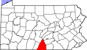
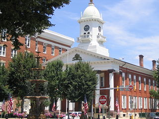
Chambersburg, Pennsylvania
| Borough of Chambersburg | |
 |
|
| Country | United States |
|---|---|
| State | Pennsylvania |
| County | Franklin County |
| Founded | 1734 |
| Incorporated | March 21, 1803 |
| Government | |
| - Mayor | Pete Lagiovane (D) |
| Area | |
| - Total | 6.9 sq mi (17.9 km²) |
| - Land | 6.9 sq mi (17.9 km²) |
| - Water | 0 sq mi (0 km²) |
| Elevation [1] | 630 ft (192 m) |
| Population (2000) | |
| - Total | 17,862 |
| - Density | 2,601.3/sq mi (1,004.4/km²) |
| Time zone | EST (UTC-5) |
| - Summer (DST) | EDT (UTC) |
| zipcodes = 17201,17202 | |
Chambersburg is a borough in Pennsylvania, United States. It is 16 miles (26 km) miles north of Maryland and the Mason-Dixon line and 52 miles (84 km) southwest of Harrisburg in the Cumberland Valley, part of the Great Appalachian Valley. The borough is the county seat of Franklin County, Pennsylvania. According to estimates conducted by the United States Census Bureau for a 12 month period ending 01 July 2007, the population of the borough is 17,940[2]. It is the center of the Chambersburg Micropolitan Statistical Area which includes surrounding Franklin County. The population of the Chambersburg Micropolitan Statistical Area in 2007 was 141,665.[3]
Chambersburg's settlement began in 1730 when water mills were built at the confluence of Conococheague Creek and Falling Spring Creek that now run through the center of the town. Its history includes episodes related to the French and Indian War, the Whiskey Rebellion, John Brown's raid on Harpers Ferry, and the American Civil War. The borough was the only major northern community burnt down by Confederate forces during the war.[4][5]
Chambersburg is located along the Lincoln Highway, US 30, between McConnellsburg and Gettysburg, Pennsylvania and along US 11, the Molly Pitcher Highway, between Shippensburg, Pennsylvania and Hagerstown, Maryland.
Contents |
History
European settlement
Native Americans living or hunting in the area during the 18th century included the Iroquois, Lenape and Shawnee[6] "Falling Spring" was first settled by Benjamin Chambers, a Scots-Irish immigrant, in 1730, who started a grist mill and saw mill by a then-26 foot high waterfall where Falling Spring Creek joined Conococheague Creek.[7][8] The creek provided power to the mills, and the settlement was known as "Falling Spring."
In 1734, Chambers was issued a "Blunston license" to settle in the area, from a representative of the Penn family, but European settlement in the area was of questionable legality until the treaty ending the French and Indian War, because not all Indian tribes with land claims had signed treaties.[7] In order to maintain peace with the Indians, European settlers were sometimes removed from the nearby area. Benjamin Chambers participated in removing settlers from Burnt Cabins in 1750.[9]
The area was officially part of Chester County, then Lancaster, and then Cumberland until it became part of the newly established Franklin County in 1784.[10]
Chambersburg was incorporated on March 21, 1803,[11] and declared the County Seat when the State Assembly established a formal government. The first courthouse was John Jack's tavern on the Diamond (town square) in 1784, with a permanent courthouse built in 1793, and the first county jail built 1795.[12] The "Old Jail" was built in 1818, survived the fire of 1864 and is the oldest jail building in Pennsylvania. It was originally used as the sheriff's residence and had the longest continuous use of any jail in the state, operating until 1971. Today the Old Jail is a museum and home to the Kittochtinny Historical Society of Chambersburg.[13] The county's gallows still stand in the jail's courtyard.[14]
The earliest church was established by Scots-Irish Presbyterians in 1734. Chambers gave land to the congregation in 1768, requiring only a single rose as annual rent. Later land was given to the First Lutheran Church (1780) and Zion Reformed Church (organized in 1780) under the same agreement, and these churches came to be known as the "Rose Rent Churches."[15] A Catholic community organized in 1785. The Jewish cemetery dates back to 1840. The Mt. Moriah First African Baptist Church dates to 1887.[7]
In 1748 a local militia was formed for protection against Indians, with Benjamin Chambers being named colonel. The Great Wagon Road connecting Philadelphia with the Shenandoah Valley passed nearby. In 1744, it was completed through Harris's Ferry, Carlisle, Shippensburg, and Chambersburg to the Potomac River.[7]
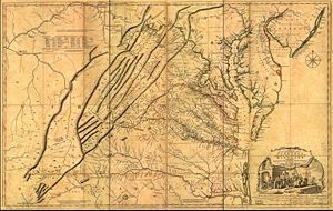
Chambersburg was on the frontier during the French and Indian War. The area's population dropped from about 3,000 in 1755 at the start of the war to about 300, with most settlers not returning until after 1764 when the peace treaty was signed.[12] Benjamin Chambers built a private stone fort during the war,[8] which was equipped with two 4 pounder cannons[7] and fighting occurred nearby.[16][6] The Forbes Road and other trails going to Fort Pitt passed nearby as well.[17][18]
Fighting continued in the area after the war, most notably the Enoch Brown school massacre during Pontiac's Rebellion and the Black Boys rebellion against British troops at Fort Loudon.
In June 1775, soon after the Battle of Lexington, local troops were raised to fight the British in the American Revolution under the command of Benjamin Chambers's eldest son Captain James Chambers,[2] as part of the 1st Pennsylvania Regiment. These troops were among the first non-New Englanders to join the siege of Boston. James Chambers fought for seven years during the revolution, reaching the rank of Brigader General. His two brothers, William and Benjamin, Jr., each served throughout the war and reached the rank of Captain.[6] Local troops fought at the Battle of Long Island, and at White Plains, Trenton, Princeton, Brandywine, Germantown and Monmouth.
During the Whiskey Rebellion, President George Washington led United States troops through town on the way from Carlisle to Bedford, staying overnight on October 12, 1794. According to tradition, Washington lodged with Dr. Robert Johnson, a surgeon in the Pennsylvania line during the Revolution.[19] This march was one of only two times that a sitting president personally commanded the military in the field. (The other was after President James Madison fled the British occupation of Washington, D.C. during the War of 1812.) After sending the troops toward Pittsburgh from Bedford under General Henry "Light Horse Harry" Lee, Washington returned through Chambersburg sometime after October 20.
Civil War era
By 1859, Chambersburg was a stop on the Underground Railroad. John Brown stayed in an upstairs room at Mary Ritner's boarding house between June and October, 1859 while preparing for his unsuccessful raid on Harpers Ferry.[20] Several of his fellow raiders stayed in the house as well, and four of them escaped capture and briefly visited the house after the raid. The house still stands at 225 East King Street. While in Chambersburg Brown posed as Dr. Isaac Smith, an iron mine developer, and bought and stored weapons under the guise of mining equipment.[21] Brown (using the name John Smith) and John Henry Kagi met with Frederick Douglass and Shields Green at an abandoned quarry outside of town to discuss the raid on August 19.[22] According to Douglass's account, Brown described the planned raid in detail and Douglass advised him against it. Douglass also provided $10 from a supporter, and had helped Green - a future raider - locate Brown.
During the American Civil War on October 10, 1862, Confederate Maj. Gen. J.E.B. Stuart, with 1800 cavalrymen, raided Chambersburg, destroying $250,000 of railroad property and taking 500 guns and hundreds of horses. Chambersburg residents said that they were remarkably well behaved.[23]
During the early days of the 1863 Gettysburg Campaign, a Virginia cavalry brigade under Brig. Gen. Albert G. Jenkins occupied the town and burned several warehouses and Cumberland Valley Railroad structures and a nearby bridge. From June 24-28, 1863, much of the Army of Northern Virginia passed through Chambersburg[24][25] en route to Carlisle and Gettysburg, and Robert E. Lee established his headquarters at a nearby farm.
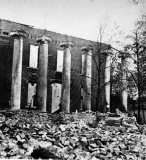
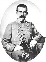
The following year, Chambersburg was invaded for a third time, as cavalry dispatched from the Shenandoah Valley by Jubal Early arrived.[4] On July 30, 1864, a large portion of the town was burned down under orders from Brig. Gen. John McCausland for failing to provide a ransom of $500,000 in US currency, or $100,000 in gold.[26][27] Among the few buildings left standing was the Masonic Temple, which had been guarded under orders by a Confederate mason.[28] Norland, the home of Republican politician and editor Alexander McClure, was burned even though it was well North of the main fire.
"Remember Chambersburg" soon became a Union battle cry.[29]
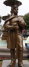
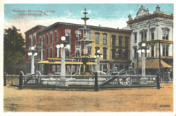
Memorial Fountain, built in the center of the diamond to honor the Civil War soldiers, was dedicated on July 17, 1878 with fifteen thousand people in attendance. A statue of a Union soldier stands next to the fountain facing south to guard against the return of southern raiders.
National Register of Historic Places
The following places in Chambersburg are on the National Register of Historic Places:[30]
| Site | Address | Listed |
|---|---|---|
| Brotherton Farm | SW of Chambersburg on Falling Spring Rd. | 1979 |
| Brown, John, House | 225 E. King St. | 1970 |
| Chambersburg Historic District | US 11 and US 30 (2320 acres, 159 buildings) | 1982 |
| Coldbrook Farm | 955 Spring Ln. | 1996 |
| Finley, James, House | Building No. 505, Letterkenny Army Depot | 1974 |
| Franklin County Courthouse | 1 N. Main St., Memorial Square | 1974 |
| Franklin County Jail | NW corner of King and 2nd Sts. | 1970 |
| Gass House | E of Chambersburg off U.S. 30 | 1977 |
| Rocky Spring Presbyterian Church | Rocky Spring Rd., approx. .5 mi. NW of Funk Rd., | 1994 |
| Masonic Temple | 74 S. 2nd St. | 1976 |
| Memorial Fountain and Statue | Memorial Square | 1978 |
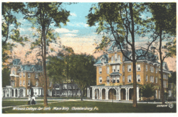
| Wilson College | 1015 Philadelphia Ave. (550 acres, 17 buildings) | 1995 |
Historic images
Colorized photographs taken from a series of 22 postcard views mailed in 1921.[31]
Geography

Chambersburg is located at (39.934813, -77.656352).[32]
According to the United States Census Bureau, the borough has a total area of 17.8 square kilometers (6.9 sq mi), all land. The elevation is 617 feet (188 m) above sea level.[33] Chambersburg is located in a valley next to the Appalachian Mountains. It also sits right outside of Caledonia State Park, a 1,125-acre (4.55 km2) park with fishing and hunting areas and hiking trails, including a section of the Appalachian Trail. Also outside of Chambersburg is Michaux State Forest, a 85,000-acre (340 km2) forest. Both of theses places provide recreation for residents.
Conococheague Creek, a noted trout stream, runs through the center of town. It is a tributary of the Potomac River. The northernmost reach of the Potomac watershed is a few miles north of town.
Chambersburg has a cold climate, according to the United States Department of Energy.[34][35] The area receives anywhere from 38 to 42 inches (1,100 mm) of precipitation per year.[36] The average January low is 20 °F (−7 °C) and the average high is 37 °F (3 °C). The average July high is 85 °F (29 °C) and the average low is 62 °F (17 °C).[37]
Demographics
As of the census[38] of 2000, there were 17,862 people, 7,722 households, and 4,386 families residing in the borough. The population density was 2,601.3 people per square mile (1,003.9/km²). There were 8,305 housing units at an average density of 1,209.5/sq mi (466.8/km²). The racial makeup of the borough was 86.43% White, 7.56% African American, 0.18% Native American, 0.87% Asian, 0.05% Pacific Islander, 3.08% from other races, and 1.83% from two or more races. Hispanic or Latino of any race were 6.38% of the population.
There were 7,722 households out of which 24.1% had children under the age of 18 living with them, 41.2% were married couples living together, 11.7% had a female householder with no husband present, and 43.2% were non-families. 37.5% of all households were made up of individuals and 16.8% had someone living alone who was 65 years of age or older. The average household size was 2.16 and the average family size was 2.83.
In the borough the population was spread out with 20.8% under the age of 18, 9.1% from 18 to 24, 26.8% from 25 to 44, 20.6% from 45 to 64, and 22.7% who were 65 years of age or older. The median age was 40 years. For every 100 females there were 81.7 males. For every 100 females age 18 and over, there were 77.1 males.
The median income for a household in the borough was $32,336, and the median income for a family was $40,352. Males had a median income of $31,803 versus $21,548 for females. The per capita income for the borough was $19,278. About 9.8% of families and 12.9% of the population were below the poverty line, including 18.3% of those under age 18 and 9.1% of those age 65 or over.
The population stood at 7,863 in 1890; 8,864 in 1900; 11,800 in 1910; 13,171 in 1920; and 14,852 in 1940. It was estimated to be at 17,961 in July 2005.
Economy
The surrounding area has a large farming population, including many Amish and Mennonite families. Franklin County's largest crop is maize (corn), with 579 farms that cover 29,916 acres (121.07 km2) of land. Franklin also has 344 wheat farms and 299 barley farms which combined cover 14,063 acres (56.91 km2).[39] Manufacturing in Chambersburg includes machinery production, metal fabrication, and food processing. According to the 1997 Economic Census[40] of Franklin County, the largest sectors by payroll were manufacturing companies such as T B Wood's Inc., Grove/Manitowoc cranes, retail trade, and health care and social assistance. The economy of the area is still largely based on agriculture.
Retail stores such as Wal-Mart and Lowe's serve the population with jobs and basic needs. The Chambersburg Mall, which houses four anchor stores plus about fifty smaller stores, is located in the unincorporated village of Scotland, about four miles (6 km) north of town on Interstate 81.[41] The retail sector has grown very quickly since 2006 with the opening of stores such as Target, Circuit City, Petsmart, Michaels, and Kohls near the newly built Exit 17 of Interstate 81. Several restaurants new to the region have opened including Starbucks (2), TGI Fridays, Red Robin, Fuddruckers, Moe's Southwest Grill, Ruby Tuesday and Panera Bread.
The city's location on Interstate 81 within 100 miles (160 km) of both Washington, D.C. and Baltimore, Maryland encourages trucking and distribution businesses.[42] The Letterkenny Army Depot five miles (8 km) north of town is a major employer. Camp David also employs Chambersburg residents. In 2004 Chambersburg had a per capita personal income (PCPI) of $28,208, below the national average of $33,050.[43]
Culture
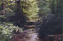
Chambersburg maintains a small town feeling. Most recreation is done through sporting events such as high school football games and baseball games. People in the area speak with a Pittsburgh English or Central Pennsylvania accent, such as over pronouncing "O's" and "I's." Caledonia State Park provides an area for outdoor activities, with the park especially busy on July 4th. Hunting is popular recreation.
The Capitol Theater was opened as a movie palace on Main Street in 1927. In 2003 it reopened as the Capitol Theatre Center and serves as home to the Capitol Theatre Main Stage and Auditorium, Chambersburg Council for the Arts, Caledonia Theatre Company, Chambersburg Ballet Theatre School and Chambersburg Community Theatre.[44]
Journalist David Brooks in 2001 used Chambersburg and Franklin County to typify Republican “Red America.” According to Brooks, there is little obvious income inequality and people don’t define their place in society by their income level. They value the work ethic and are anti-union, anti-welfare, pro-free market, and religious social conservatives.
| “ |
The joke that Pennsylvanians tell about their state is that it has Philadelphia on one end, Pittsburgh on the other, and Alabama in the middle. Franklin County is in the Alabama part…. The local culture owes more to Nashville, Houston, and Daytona than to Washington, Philadelphia, or New York…. The conservatism I found in Franklin County is not an ideological or a reactionary conservatism. It is a temperamental conservatism. People place tremendous value on being agreeable, civil, and kind…. They value continuity and revere the past.[45] |
” |
Government
The municipal government operates under the Pennsylvania Borough Code, with the Town Council holding both legislative and executive authority. The ten councilmen are elected from five wards; two from each ward with staggered four year terms. The Mayor administers the Police Department and can cast tie-breaking votes on the Council. Other departments are administered by the Borough Manager.[46]
Pete Lagiovane became Mayor on January 7, 2008.[47]
As of January 2008, the town councilmen are:
- 1st Ward: William F. McLaughlin (President of Council) and Allen B. Coffman
- 2nd Ward: Thomas L. Newcomer and Janet L. Lukic
- 3rd Ward: Elaine M. Swartz and Glenn K. Manns (Finance Chairman)
- 4th Ward: Mary Beth Shank and Sharon A. Bigler (Assistant Finance Chairman)
- 5th Ward: Heath Talhelm and Robert A.Wareham, Sr. (Vice-President of Council)
Chambersburg is part of the 9th Congressional District of Pennsylvania and represented by Bill Shuster (R) in the House of Representatives, and by Arlen Spector (R), and Bob Casey, Jr.(D) in the Senate.
Education
- Further information: Wilson College (Pennsylvania)
- Further information: Chambersburg Area Senior High School
Wilson College is a private, Presbyterian-related, liberal arts women's college founded in 1869 and named for its first major donor, Sarah Wilson of Chambersburg. The college has 800 students and is known for its Women With Children, Veterinary Medical Technician, and Equestrian programs.
Chambersburg Area Senior High School (CASHS) is a public school with around 1,800 students in grades 10-12, drawn from the borough of Chambersburg and the surrounding townships of Hamilton, Greene, Lurgan, Letterkenny and Guilford. CASHS is accredited by the Middle States Association and has occupied its current facilities since 1955. Principal Dr. Barry Purvis was recognized as the 2006 High School Principal of the Year by the Pennsylvania Association of Elementary and Secondary School Principals.[48]
The Scotland School for Veteran's Children (SSVC) is a state owned school that offers tuition-free residential education programs for children of Pennsylvania residents who are veterans or are currently serving in the U.S. armed forces.[49] It is located about four miles (6 km) north of Chambersburg in the unincorporated village of Scotland and has about 300 students in grades 3-12. The school was established in 1895 as the Pennsylvania Soldiers Orphans Industrial School. Over 10,000 students have been educated at the school. The 186-acre (0.75 km2) campus contains about 70 buildings including residential cottages.[50]
J. Frank Faust Junior High School is the only public junior high school for eighth and ninth grade students of the Chambersburg Area School District. It serves about 1400 students.
Chambersburg Area Middle School (CAMS) is the only public school for sixth and seventh grade students in the Chambersburg Area School District. During the 2001-02 school year, CAMS was recognized with the Blue Ribbon School Award of Excellence by the United States Department of Education,[51] the highest award an American school can receive.[52][53]
The Chambersburg school district includes seventeen elementary schools. Many school are being upgraded, rebuilt, or closed because of out-of-date buildings and lack of space. As of July 2008, the current School Board President is Stanley Helman, other members include Anne Boryan, Renee Sharpe, Norman Blowers, Lori Leedy, Fred Rice, Dave Schiamanna, and Joe Tosten. One seat is currently being filled after the resignation of the previous board president, Dr. Thomas Orndorff. [54]
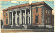
Private schools include Corpus Christi, a Catholic school with 310 students and over 20 teachers,[55] and Cumberland Valley Christian School, a private Christian kindergarten through twelfth grade academy located in Chambersburg. Cumberland Valley Christian School is affiliated with the Open Door Church and has approximately four hundred students. Other private schools include the Montessori Academy of Chambersburg (22 months-8th grade, non-denominational) and Shalom Christian Academy (K-12, Mennonite affiliation), and several elementary schools with Mennonite, Baptist, Brethern, Christian Science, and other religious orientations.[56]
Coyle Free Library[57] has roots going back to 1891[58] when a library of 166 books was organized by the local Afternoon Club. A member of the club, Blanche Coyle, left of bequest of $30,435 in 1915 to construct a library building. The building was completed in 1924, located at the corner of Second and Queen Streets. Later the library was made part of the Franklin County Library and began to receive funds from the County and State, though the Afternoon Club still donated funds though at least 1979. The building currently occupied is a former post office.
Media
Newspapers
The Chambersburg Public Opinion is the only daily newspaper published in town, and has weekday circulation about 17,000. It was founded in 1869 and is now owned in partnership by Gannett and MediaNews Group.[59]
Television and radio
Television reception can be poor because of the surrounding mountains. WJAL, a family oriented station broadcasts from Chambersburg, and Harrisburg PBS station WITF-TV rebroadcasts via low-powered translator W38AN. Three channels, WHAG-TV, WWPB, and WWPX, broadcast from nearby Hagerstown, Maryland.
Chambersburg shares a radio market, the 166th largest in the United States, with Waynesboro, Pennsylvania and Hagerstown, Maryland.[60].
|
|||||||||||||||||
|
||||||||||||||
Sister city
 Gotemba, Shizuoka, Japan
Notable residents and natives

- Philip Berlin, inventor of the first railroad sleeping car.[61]
- Tom Brookens, pro baseball player from 1979-1990. Played third-base for the 1984 World Series Champion Detroit Tigers. Now coaches the Detroit Tigers minor league affiliate West Michigan Whitecaps (A)
- Revolutionary War soldier Margaret Corbin, known as "Captain Molly."
- Abolistionist publisher Martin Delany, who in 1865 became the first African-American field officer in the U.S. Army, was educated in Chambersburg in the 1830s.
- Henry Burchard Fine (1858-1928) was a dean at Princeton University and mathematician.
- Baseball Hall of Famer Nellie Fox was born and lived just west of town in St. Thomas Township.
- Patrick Gass (1771-1870), the last surviving member of the Lewis and Clark expedition was born just outside Chambersburg (Falling Spring).
- The Rev. John Grier Hibben, later President of Princeton University, served as pastor of Falling Spring Presbyterian Church, 1888-1891.

- Stephen D. Houston a renowned Mayanist scholar, epigrapher and anthropologist was born in Chambersburg in 1958.
- Archbishop John Hughes lived in Chambersburg between 1817 to 1819 before going on to Mount St. Mary's University his family are buried at the Corpus Christi Church Cemetery in Chambersburg.
- Alexander McClure, editor of the Franklin Repository from 1852-1864.
- David Fullerton Robison, a U.S. Representative, who in 1859 died of National Hotel disease.
- Charena Swann wife of Lynn Swann.
- Joseph Winters an African-American inventor and abolitionist, moved to Chambersburg in 1830.
- Sarah Wilson the namesake and first major donor of Wilson College, 1869, a private women's college.
References
- ↑ USGS GNIS: Chambersburg. Geographic Names Information System. Retrieved April 25, 2007.
- ↑ Table 4: Annual Estimates of the Population for Incorporated Places in Pennsylvania, Listed Alphabetically: April 1, 2000 to July 1, 2007, U.S. Census Bureau, 2007. Retrieved 13 July 2008.
- ↑ "Annual Estimates of the Population of Metropolitan and Micropolitan Statistical Areas: April 1, 2000 to July 1, 2007 (CBSA-EST2007-01)" (CSV). 2007 Population Estimates. United States Census Bureau, Population Division (2007-03-27). Retrieved on 2008-05-27.
- ↑ 4.0 4.1 "War Comes Home, Chambersburg 1864". The Valley of the Shadow. Retrieved on 2007-09-21.
- ↑ Morvay, Joanne E. (January 13, 2005). "Chambersburg's rich war history, Pa. town rebuilt after burning in the Civil War", Hartford Courant. Retrieved on 2008-10-31.
- ↑ 6.0 6.1 6.2 "History of Franklin County Pennsylvania". rootsweb.com (1887). Retrieved on 2007-09-21.
- ↑ 7.0 7.1 7.2 7.3 7.4 John R. Schein, Jr. and Ray C. Hearne (July 31, 1980), National Register of Historic Places Inventory-Nomination: Chambersburg Historic DistrictPDF (32 KB), National Park Service
- ↑ 8.0 8.1 "Chambersburg". 1911 Encyclopedia Britannica (1911). Retrieved on 2007-09-21.
- ↑ http://www.hartslog.org/Place%20hl.htm Hartslog Society
- ↑ "History". borough.chambersburg.pa.us. Retrieved on 2007-09-21.
- ↑ "History of PA Counties". stubblebinefamily.com. Retrieved on 2007-09-21.
- ↑ 12.0 12.1 "Franklin County, Pennsylvania USGENWEB Project". Kittochtinny Historical Society. Retrieved on 2007-09-21.
- ↑ "Historical Sites". chambersburg.biz. Retrieved on 2007-09-21.
- ↑ "Artisan Cheese Trail" (PDF). VisitPA.com. Retrieved on 2008-08-11.
- ↑ "Zion Reformed Church". Zion Reformed Church. Retrieved on 2007-09-21.
- ↑ "The French and Indian War in Pennsylvania". explorepahistory.com. Retrieved on 2007-09-21.
- ↑ "The Pennsylvania Road" (PDF). home.kc.rr.com. Retrieved on 2007-09-21.
- ↑ "The Point: Indian Trails to Fort Duquesne". The Carnegie Library of Pittsburg. Retrieved on 2007-09-21.
- ↑ "The Diaries of George Washington". The Carnegie Library of Pittsburg. Retrieved on 2007-03-25.
- ↑ "Collection of letters from Chambersburg, Familytales.org". Retrieved on 2008-02-26.
- ↑ "John Brown House". nps.gov. Retrieved on 2007-09-21.
- ↑ "Excerpt from The Life and Times of Frederick Douglass pp. 350-354". Reprint New York: Pathway Press (1941). Retrieved on 2007-09-21.
- ↑ "Stuart's Raid". valley.vcdh.virginia.edu. Retrieved on 2007-09-21.
- ↑ "The Gettysburg Campaign". civilwarhome.com. Retrieved on 2007-09-21.
- ↑ "Geology and the Gettysburg Campaign" (PDF). Pennsylvania Department of Conservation and Natural Resources (1962). Retrieved on 2007-09-21.
- ↑ "Franklin County: "The Burning of Chambersburg,"". valley.vcdh.virginia.edu (1870-08-27). Retrieved on 2007-09-21.
- ↑ Davis, Jefferson (1881 (Reprinted 1990 Da Capo Press)). Rise and Fall of the Confederate Government (Volume II). New York: D. Appleton and Company. pp. 532 – 533. ISBN 0306804182. http://books.google.com/books?vid=0HTUpyAbxWo-hPey91dA09&id=4xXZKU1FfCgC&dq=%22Chambersburg,+Pennsylvania%22.
- ↑ "Burning of Chambersburg". explorepahistory.com. Retrieved on 2007-09-21.
- ↑ Liva Baker (August 1973). "Burning of Chambersburg". American Heritage Magazine. Retrieved on 2007-09-21.
- ↑ "National Register of Historic Places". NationalRegisterofHistoricPlaces.com. Retrieved on 2007-09-21.
- ↑ The Vally of the Shadow War and Peace in the 1920s, Chambersburg Souvenier, accessed June 14, 2008
- ↑ "US Gazetteer files: 2000 and 1990". United States Census Bureau (2005-05-03). Retrieved on 2008-01-31.
- ↑ "Chambersburg, Pennsylvania". epodunk.com. Retrieved on 2007-09-21.
- ↑ "Building America" (PDF). eere.energy.gov. Retrieved on 2007-09-21.
- ↑ "Climate Regions". eere.energy.gov. Retrieved on 2007-09-21.
- ↑ "Average Annual Precipitation". ocs.orst.edu. Retrieved on 2007-09-21.
- ↑ "Chambersburg, Pennsylvania". Weather.com. Retrieved on 2007-09-21.
- ↑ "American FactFinder". United States Census Bureau. Retrieved on 2008-01-31.
- ↑ "Pennsylvania Crop Map". Purdue University. Retrieved on 2007-09-21.
- ↑ "1997 Economic Census Summary Statistics for Franklin County, PA". census.gov. Retrieved on 2007-09-21.
- ↑ "Chambersburg Mall". Chambersburg Mall website. Retrieved on 2007-09-21.
- ↑ David Brooks, One Nation, Slightly Divisible; The Atlantic Monthly; December 2001; Volume 288, No. 5; 53-65. [1]
- ↑ "Franklin County, PA". Bureau of Economic Analysis. Retrieved on 2007-09-21.
- ↑ "A Cultural Centerpiece: Chambersburg's Capitol Theatre". Hagarstown Magazine. Retrieved on 2008-03-08.
- ↑ David Brooks, One Nation, Slightly Divisible, The Atlantic Monthly, December 2001.
- ↑ "Borough of Chambersburg - Structure". www.borough.chambersburg.pa.us. Retrieved on 2007-09-21.
- ↑ "2008-2009 Borough Council". www.borough.chambersburg.pa.us. Retrieved on 2008-01-22.
- ↑ "Dr. Barry Purvis of CASHS named state High School Principal of the Year". thegazettenews.com (2006-02-15). Retrieved on 2007-09-21.
- ↑ "Scotland School for Veteran's Children". Scotland School for Veteran's Children website (2006-02-15). Retrieved on 2007-09-21.
- ↑ Scotland School for Veteran's Children website accessed May 16, 2007
- ↑ Blue Ribbon Schools Program: Schools Recognized 1982-1983 through 1999-2002 (PDF), accessed May 11, 2006
- ↑ CIBA cited as one of the best by Education Department, Journal Inquirer, November 16, 2006. "The Blue Ribbon award is given only to schools that reach the top 10 percent of their state's testing scores over several years or show significant gains in student achievement. It is considered the highest honor a school can achieve."
- ↑ Viers Mill School Wins Blue Ribbon; School Scored High on Statewide Test; The Washington Post. September 29, 2005 "For their accomplishments, all three schools this month earned the status of Blue Ribbon School, the highest honor the U.S. Education Department can bestow upon a school."
- ↑ CASD Webpage accessed May 29, 2008.</
- ↑ Corpus Christi school website
- ↑ Private Schools in Chambersburg PA accessed March 24, 2007.
- ↑ Coyle Free Library
- ↑ Manuscript from the Coyle Free Library, Our Library Roots and Branches, Jane K. Schleicher, Librarian, November 7, 1979 accessed March 25, 2007.
- ↑ Public Opinion About Us: Public Opinion: Part of life in the Cumberland Valley
- ↑ Market Ranks and Schedules 151-200, Arbitron, Fall 2007, Retrieved 22 March 2008.
- ↑ http://www.explorepahistory.com/hmarker.php?markerId=670
Further reading
- Garrard, Lewis Hector (1856), Chambersburg in the Colony and the Revolution: A Sketch, Philadelphia: J.B. Lippincott, Available from Google Books
- Bates, Samuel P. (1887), History of Franklin County, Chicago: Warner, Beers, & Co., available at Internet Archives
- Images of America: Chambersburg, Maurice Leonard Marotte III & Janet Kay Pollard (Arcadia, 2005)
See also
- Fayetteville, Pennsylvania
- Franklin County Regional Airport
- Guilford, Pennsylvania
- The Valley of the Shadow
- WHGT
External links
- Official website
- Public Opinion – local newspaper
- Chambersburg Chamber of Commerce
- Franklin County Historical Society-Kittochtinny
- The Burning of Chambersburg
- The Old Jewish Cemetery of Chambersburg
- Council For The Arts
- CASHS Official Link
- CAMS Official Link
- J. Frank Faust Jr. High School Official Link
- Chambersburg, Pennsylvania is at coordinates
|
|||||||||||||||||||||||
|
|
