Cartagena, Colombia
| Cartagena de Indias | |||
 |
|||
|
|||
| Nickname(s): The Heroic City The Door of the Americas Capital of the Caribbean The Mother City The Walled City The Key of the West Indies The Fort of the Kingdom Best Fortified City of the Americas |
|||
 |
|||
| Coordinates: | |||
| Department | Bolívar Department | ||
|---|---|---|---|
| Region | Caribbean Region | ||
| Foundation | June 1, 1533 by Don Pedro de Heredia | ||
| Government | |||
| - Mayor | Judith Pinedo, Independent | ||
| Area | |||
| - City | 572 km² (220.9 sq mi) | ||
| Elevation | 1 m (3 ft) | ||
| Population (2006) | |||
| - City | ▲ 1,090,349 | ||
| - Metro | ▲ 1,239,430 | ||
| - Demonym | Cartagenero (s) (Spanish) | ||
| Time zone | EST (UTC-5) | ||
| Area code(s) | (57)-(5) | ||
| HDI (2008) | ▲ 0.798 – Medium. | ||
| City tree | Arecaceae | ||
| City bird | American Crow Locally called Mariamulata | ||
| Saint Patron(s) | Saint Catherine and Saint Sebastian. | ||
| Website: (Spanish) Government of Cartagena official website Tourism Office Official Site |
|||

Cartagena de Indias (pronounced [kaɾtaˈhena ð̞e ˈin̪d̪jas] in Spanish; the usual English pronunciation is IPA: /ˌkɑrtəˈheɪnə deɪ ˈɪndiəs/), is a large city seaport on the northern coast of Colombia. Capital of the Bolívar Department, it has a population of 1,240,000 in its Metropolitan Area, and 1,090,000 in the city (2005 Census), being the fifth largest urban area in Colombia. Founded in 1533 by Spaniard Don Pedro de Heredia, and named after the port of Cartagena in Spain's Murcia region, it was a major center of early Spanish settlement in the Americas which had impressive development in the XVIII century as the de facto capital of the Viceroyalty of New Granada and as the main hub of commerce and transportation in the late viceroyal era, situation that is reflected in its alternative capitality today. Nowadays continues to be the economic hub of the Caribbean region as well as a popular tourist destination.
Cartagena's colonial walled city and fortress were designated a UNESCO World Heritage Site in 1980 along with Lima.
Contents |
History
Precolombian Era - 7000 BC - 1500 AD
The Caribbean region, particularly in the area from the Sinu River delta to the Cartagena de Indias bay, appears to be the first documented human community in today's Colombia: the Puerto Hormiga Culture.
Until the Spanish colonization many cultures derived from the Karib, Malibu and Arawak language families lived along the Caribbean Colombian coast. In the late pre-Columbian era, the Sierra Nevada de Santa Marta, was home to the Tayrona people, closely related with the Chibcha family language. [1] [2]

Archaeologists estimate that around 7000 BC, the settlement of the formative Puerto Hormiga Culture, located near the limits between the departments of Bolívar and Sucre was established. In this area archaeologists have found the most ancient ceramic objects in the Americas, dating from around 4000 BC. The primary reason for the proliferation of primitive societies in this area is the relative mildness of climate and the abundance of wildlife which through continuous hunting allowed the inhabitants a comfortable life. [3] [4] [5]
In today's villages of Maria La Baja, Sincerín, El Viso and Mahates and Rotinet, there have also been discoveries of the remains of culturally organized societies through the excavation of maloka type buildings, which are directly related to the early Puerto Hormiga settlements. [5]

Archaeological investigations date the decline of the Puerto Hormiga culture and its related settlements to around 3000 BC. The rise of a much more developed culture, the Monsú, who lived at the end of the Dique Canal, near today's Cartagena neighborhoods Pasacaballos and Ciénaga Honda at the northernmost part of Barú Island. The Monsú culture inherited the Puerto Hormiga culture´s use of the art of pottery but also developed a mixed economy of agriculture and basic manufacture. the Monsú people's diet was based mostly on seashells, sweet- and salt-water fish. [6]
The ethnologists who discovered Monsú, the Gerardo Reichel-Dolmatoff marriage, found an interesting artificial mound created by them consisting in vases and rests of skeletons. After the first excavations, the Monsú mound was found to be a communal hut that had strong wood logs around it and was built on different levels, each one from a different period of time. The most ancient of these is the Turbana[7] Period, from 3350 BC. This archaeological zone, less than 6 miles from Cartagena de Indias' downtown boasts the most complete collection of ceramic instruments in Colombia and the American continent.[3] The ceramic patterns found in Monsú, are a tour de force for students of archeology of the Caribbean sea basin and northern South America.
The Reichel-Dolmatoffs later found other artificial mounds, dating from 3200 to 1000 BC, thus making the suburbs of modern Cartagena the seat of the first organized society in Colombia, and one of the most ancient in the Americas.
The development of the Sinú society in today's department of Cordoba and Sucre, eclipsed these first developments around the Cartagena Bay area. Around 1500 the area was inhabited by different tribes of the Karib language family, more precisely the Mocanae sub-family. These were:
- In the downtown island: Kalamarí Tribe
- In the Tierrabomba island: Carex Tribe
- In the Barú island, then peninsula: Bahaire Tribe
- In the eastern coast of the exterior bay: Cospique Tribe
- In the suburban area of Turbaco: Yurbaco Tribe
Some subsidiary tribes of the Kalamari lived in today's neighborhood of Pie de la Popa, and other subsidiaries from the Cospique lived in the Membrillal and Pasacaballos areas. Among these, according to the first chronicles the Kalamari Tribe had preeminence.
These tribes, though physically and administratively separated, shared common architecture, such as hut structures consisting of circular rooms with tall roofs inside wooden palisades.[8]

First Sightings - 1500 - 1533
Since the failed foundation of Antigua del Darién in 1506 by Alonso de Ojeda, and the subsequent failed city of San Sebastian de Urabá in 1517 by Diego de Nicuesa, the southern Caribbean coast became a bit unattractive to colonizers, which preferred the more known Hispaniola and Cuba.[9]

Though, the Casa de Contratación gave permission to Rodrigo De Bastidas to again, conduct an expedition as adelantado to this areas. Bastidas, explored the coast and discovered the Magdalena River delta in his first journey from Guajira to the south in 1527, trip that ended in the Urabá gulf, seat of the failed first settlements. De Nicuesa and De Ojeda noted the existence of a big bay on the way from Santo Domingo to Urabá and Panama isthmus, encouraging De Bastidas to investigate. [10] [11]

In this first trip, he passed away Cartagena de Indias's bay but noted that in future voyages he will investigate this "immense bay, perfect for ships." This second trip was made in 1530, and the calculations were true: it was an enormous bay with profound waters. After the discovery, De Bastidas returned to Santa Marta, recently founded by him in 1528.[12] [13]
Colonial Era - 1533-1717

Cartagena de Indias was founded the 1st of June, 1533 by Spanish commander Pedro de Heredia, in the former seat of the indigenous Caribbean Calamarí village. See Juan de la Cosa).[14]

Initially, life in the city was quite bucolic, with less than 2000 inhabitants and only one church. A few months after the disaster of the invasion of Cote (see below), a fire burned the city to the ground and forced the creation of a Firefighting Squad, the first in the Americas.[15]
The dramatically increasing fame and wealth of the prosperous city turned it an attractive plunder site for pirates and corsairs. Just 30 years after its founding, the city was pillaged by French pirate Robert Baal. Afterwards, the city began to rebuild itself in more noble materials (stone and similar) and to surround itself with walled compounds and castles. [16] Martin Cote attacked years later.

Many pirates intended the same on Cartagena who was more and more notorious in the thieves' guilds in Europe:
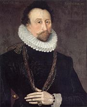
- Sir John Hawkins (England): Tried to trick Gov. Martín de las Alas in 1568 to open (against the Spanish Law) a foreign fair in the city to sell its goods for then ravaging the port. The Governor declined and Hawkins tried to siege but failed. [17] [18] [19]
- Sir Francis Drake (England): Nephew of Hawkins, the famed pirate came with a strong fleet and quickly took the city. The Governor Pedro Fernández de Bustos and the Archbishop fled to the neighbouring town of Turbaco and from there negotiated the costly ransom for the city: 107,000 Spanish dollars of the time (Around 200 mill. of today's USD), in any case, the future "Sir" destroyed 1/4 of the city, the developing Palace of the Township and the recently finished Cathedral. After this disaster Spain poured millions every year to the city for its protection, beginning with Gov. Francisco de Murga's planning of the walls and forts; this practice was called "Situado". The magnitude of this subsidy is shown by comparison: between 1751 and 1810, the city received the sum of 20,912,677 Spanish dollars, the equivalent of some 2 trillion dollars today.[20] [21]
- Sire Bernard Desjeans, Baron de Pointis, Jean Ducasse 1697. Raid on Cartagena (1697) The city recovered quickly from the horrible takeover of Drake and kept growing. The port now seat of the Inquisition in the Caribbean (with Lima's and Mexico's the only 3 seats in America), many public buildings and servants, its importance was confirmed. Desjeans's plans were far more than pillage: it was an invasion by all means. The muscles of King Louis XIV were decided to take over the decaying Spain of the Austria dynasty and Cartagena de Indias was his entry. The altruistic purpose of the invasion, not pirate entry was shadowed by the governor of Saint-Domingue (Today's Haiti) Jean Baptiste Ducasse who brought his soldiers just to steal and finally the original plan ended as pirates and thieves again destroying the city. In any case, the entry wasn't easy, because of the recently finished first stage of walls and forts which slowed and made costly the victory. While Desjeans only asked for 250,000 Spanish dollars in ransom, Jean Ducasse stayed a few months later and dishonoured the promise of the Baron of respecting the churches and holy places and left them with nothing. The city again, lost everything. The XVIII century begins.
Other important events in the XVI-XVII century were:
- The brother of the founder, Pedro de Heredia, Alonso de Heredia founded Mompox, with the name Santa Cruz de Mompox to honour the actual governor of the province, José de Santacruz who was about to make another unjust Residencia to his brother, planned by his enemies in the city. Residencia successfully overcame by Heredia who later Residenced Santacruz for his greed in the expedition made by him to Urabá in late 1537.
- In its typical decentralised and autonomistic state policy, Spain put in Cartagena de Indias many offices that are normally in the Capital of the area in question (in this case, not in Bogota). This are:
1. The Royal Houses of Customs: Technically the Main directorate for Customs policy in the New Grenada and its dependencies. Today's Cartagena de Indias's mayors office is there.
2. The Royal Houses of Accountance: Most of its competence was in the State Finance area, making it analogous to a Ministry of Finance or a Secretary of the Treasury. This office was in today's Mapfre House (La Inquisicion Street)
3. The Royal Mail House: More developed in the XVIII century, began in 1540 and stayed permanently in the City until 1821 when renamed, delivered most of the post in the New Grenada and to Europe. Today's SUDEB house occupies its original place.
4. The Royal Consulate of Commerce of Cartagena de Indias: A privately-run institution with public charter, the Consulates of Commerce were express courts for trading quarrels and to promote trade and development in its area. Until 1790 was the only in the area, then succeeded by Caracas (1790), Mompox (1793), Panamá (1798), Santafé (1805) and others.
5. The Hospital of the Navies: First and Only military hospital in the area, and until the foundation of the San Juan De Dios Hospital in Bogota the only in New Grenada, in its first floor a Poor people's Hospital worked until was developed the San Carlos Hospital in 1730 and the Poor people's was opened up in the Santa Clara convent. The Hospital worked in today's Naval Museum, the poor's Hospital in its first floor and the later ones in Gastelbondo Street (San Carlos), and today's Sofitel Santa Clara Hotel (Poor people's Hospital of Santa Clara of Assisi).
6. Royal Headquarters of the Regular Armies of Cartagena de Indias: In the New Grenada, like in most Spanish America, military presence was at least nule and when present was quite concentrated in the important hubs: Havana, Mexico City, Lima, Panama and Cartagena de Indias. The only Regular (always present) army in the New Grenada has its Headquarters in today's Judges Offices in Cuartel Street. This made Cartagena de Indias also the seat to something similar to a Ministry of Defense in a modern Country.

- During the governorship of Rafael Cápsir an interesting event occurred in the city: the "Cessatio a Divinis". The nuns of the Santa Clara convent, who grew richer than the Franciscan friars from donations and more intelligent investments of those wanted to become independent of them in the financial area. The Archbishop agreed with the petition of the nuns but the Franciscans protested and made party with the Governor and he decided to storm the Convent, while the Archbishop forbade the head of the Franciscans to say mass (Cessatio a Divinis). The nuns wanted to reverse their petition but the Archbishop was already exalted and persuaded them to continue. The city was terribly distressed by the conflict which saw daily fights in the streets between the partidaries of each faction (Something similar to Menéndez's "Spain in the XVI-XVII century was a friarish democracy."). The conflict ended finally with the tutelage of the Franciscans over the nuns ending, but the archbishop was banned from the city.

- The Portuguese Company of Cacheu, dedicated to Slave Trading is closed down by the Crown because of accounting fraud and tax evasion. The famed slave company was stationed on front of today's Marquis de Valdehoyos house (Calle de la Factoría).
- The monk Pedro Claver began his ministry of the enslaved in Cartagena, work that gained for his name the Sanctity in the late XIX century.
- The Township Palace and Governors House was finished.

The fame of this prosperous city turned it into the plunder site for pirates and thieves; the legions for the country’s defence soon became insufficient, which is why the kings of Spain decided to approve the construction of castles, forts, and walls that surrounded the city.
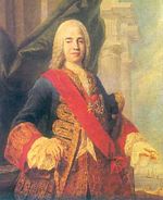
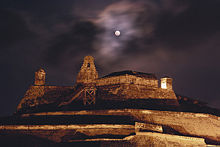
In order to resist these attacks, during the 17th century the Spanish Crown hired the services of prominent European military engineers to carry out the construction of fortresses, which are nowadays one of Cartagena's clearest signs of identity. This construction took 208 years, and ended with some eleven kilometres of walls surrounding the city, the San Felipe de Barajas Castle, named in honor of Spain's King Philip IV and its most decided public servant in the construction: Gov. Pedro Zapata de Mendoza, Marquis of Barajas, constructed to repel land attacks, equipped with sentry boxes, buildings for food and weapons storage, underground tunnels;
The complex was completed with: 1. The San Sebastián del Pastelillo Fort: in today's neighborhood of Manga, called del Pastelillo (the cupcake) because of its low altitude to avoid being affected by the Castle of San Felipe whose cannons may have destroyed it if made taller. The fort replaced the first defense of the city: The Tower of Boquerón, a medievalesque tower that dominated the bay and city, similar to Torre del Homenaje in Santo Domingo, but round.

2. The Santa Cruz de Castillogrande Fort: in today's neighborhood of Castillogrande, specifically in the Naval Club, a cross shaped fort which controlled the entry in the inner bay.
3. The San Juan de Manzanillo Fort: smaller than its brother in Castillogrande, in order to not crossfiring it, but in the opposite side of the strait.
4. The San Luis de Bocachica fort: Beautifully finished cross shaped fort, an exponent of the renaissance military architecture, dominated alone the Bocachica strait which lead to the ocean but was destroyed by Vernon in the XVIII century, only some remains are over some places of Bocachica, near its successor, the San Fernando fort.
5. The San Fernando de Bocachica fort: Built nearer to the Sea than its older brother, the San Luis, it was more modern and state-of-the-art, being more roundly shaped, with space for more musketeers rather than massive cannons, and fare more neoclassical and delicate in its outer layers, revealing the tendency in military architecture in the XVIII century.
6. The San José de Bocachica batteries: Built with the new plan of the San Fernando Fort, was designed to point to the line of flotation of the ships, and that's why its almost under sea level.
7. The Angel San Rafael Battery: A masterpiece of the History of Military Architecture, its the only exponent in the world of "inside defense" The battery has few cannons to the outside, only the necessary to support the defense of San Fernando but its use was to attract the sieging forces to enter in a tunnel that appear as accidentally opened 500 meters away from the fort, so they are attracted to take it easily to siege the castle of San Fernando. When the tunnel ends, it enters to a dry moat inside the battery and where if fully equipped more than 400 muskets are pointing just at the first entrance, the design of the "devil holes" where the muskets are, avoid to the invader to see them and death is automatic. No one ever intended catch the trap but to prove it tests were done with cattle in the late XVIII century and the theory was confirmed. Recently the battery, a jewel of the crown in the military architecture history, was rebuilt after years of abandon.
8. The Santa Barbara Battery: Designed near the tunnel entrance to Angel San Rafael was a small battery used as a decoy and to support fire to the Bocachica system, its most important object was to attract the siegers to the mainland so they can see the tunnel entrance and die at the Angel San Rafael death moat. The Santa Barbara battery disappeared with the years, only its founding stones remain over the seas.
9. The Batteries of Chamba and Santiago: Mainly designed as support batteries for San Luis fort, but after the destruction of it by a resented Vernon he brutalized ever more these forts that had the unfortunate luck of being in a very deep sea area which made easy to destroy from a small distance. Ruins remain of both in the oceanic shore of the Tierrabomba Island, no plans exist to rebuild them.

10. The Batteries of Mas, Crespo and the Revellín of El cabrero.: Destroyed by erosion and the desperate efforts of the XIX century administrations to dinamize the city's building industry were support forts for the massive San Lucas and Santa Catalina fortresses in the city Walls.

11. The walls of the old city. 11 km of walls, more than 20 mini forts within it, 4 auxiliary doors, only one bridge-fort to connect the city to the mainland.
Explanations are unnecessary: when the defenses were finished in 1756, the city was simply impossible to take over. There is a legend, that when reviewing the costs of the defenses of Spain in Havana and Cartagena de Indias, in an effort to reform the chronic spending of his predecessors, Charles III of Spain, in his famed ironical style said while taking his spyglass: "This is outrageous! For this price those castles should be seen from here! (Peninsular Spain)."
Cartagena was a major trading port, specially for precious metals. Gold and silver from the mines in New Granada and Peru were loaded in Cartagena on the galleons bound for Spain via Havana. Cartagena was also a slave port; Cartagena and Veracruz (México) were the only cities authorized to trade with black people. The first slaves arrived with Pedro de Heredia and they worked as cane cutters to open roads, in the desecration of tombs of the aboriginal population of Sinu, and in the construction of buildings and fortresses. The agents of the Portuguese company Cacheu distributed human 'cargos' from Cartagena for mine exploitation in Venezuela, the West Indies, the Nuevo Reino de Granada and the Viceroyalty of Perú.
On 5 February 1610, the Catholic Monarchs established from Spain the Inquisition Holy Office Court in Cartagena de Indias by a Royal Decree issued by King Philip II. The Inquisition Palace, finished in 1770, is still there with its original features of colonial times. When Cartagena declared its complete independence from Spain on November 11, 1811, the inquisitors were urged to leave the city. The Inquisition operated again after the Reconquest in 1815, but it disappeared definitely when Spain surrendered six years later before the patriotic troops led by Simón Bolívar.
Viceroyal Era - 1717-1810
Although the XVIII century began very bad for the city, soon the downward tendency was curbed. The pro-trade economic policies of the new dynasty in Madrid bolstered the economic performance of Cartagena de Indias and the establishment of the Viceroyalty of the New Grenada in 1717 had the city as the greatest beneficiary of the colony.
The reconstruction after the Raid on Cartagena (1697) was initially slow, but with the ending of the Spanish Succesion War and the competent administration of D. Juan Diaz de Torrezar Pimienta the walls were rebuilt, the forts reorganized and restored and the public services and buildings reopened. By 1710, the city was fully recovered. At the same time, the slow but steady reforms of the restricted trade policies in the Spanish Empire encouraged the establishment of new trade houses and private projects. During the reign of Phillip V of Spain the city had many new public works beginning or finishing like the new fort of San Fernando, the Hospital of the Obra Pía and the full pavimentation of all the streets and the opening of new roads.

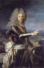
The developement of the early XVIII century stopped because in March 1741 the city endured a large-scale attack by British and American colonial troops led by admiral Edward Vernon, who arrived at Cartagena with a massive fleet of 186 ships and 23,600 men against only 6 Spanish ships and 3,600 men, in an action known as the Battle of Cartagena de Indias. After weeks of intense fighting, the siege was repelled by the Spanish and native forces led by commander General Blas de Lezo, who inflicted heavy casualties on the English troops. This victory prolonged Spain's control of the Caribbean waters, which helped secure its large Empire until the 19th century. Admrial Vernon was accompanied by American Colonial trooops, including George Washington's brother, Lawrence, who was so impressed with Vernon he named Mount Vernon after him.


After Vernon began what is called the Silver Age of the city (1750-1808). This time was of permanent expansion of the existing buildings, massive inmigration from all the other cities of the Viceroyalty, the increase of the economic and political power of the City and a population spur that hasn't been seen yet again. For these events, the political power that was already shifting from Bogota to the coast, definitely did and the Viceroys decided to reside in the city for good. The inhabitants of the city were the richest of the colony, the aristocracy formed noble houses with their land estates, libraries and prints were opened, and even the first café in the New Grenada was established. These good times of steady progress and advance of the second half of the XVIII century came into an abrupt end in 1808, with the general crisis of the Spanish Empire, embodied in the Mutiny of Aranjuez, with all its consequences.
For more than 250 years, Cartagena was part of the Spanish Crown. On November 11th, 1811, Cartagena declared its independence, and began another chapter in its history that has been anything but easy, its title ‘The Heroic City’ is well earned and reflects the life of the city.
Peninsular War, Revolution, Crisis, Independence and the XIX century - 1810-1900
If there is a word to describe the Cartagena in the XIX century, is by far: decadence. Followed by instability, revolution, impoverishment and depopulation. The chaos brought by the Mutiny of Aranjuez to the Empire and the french Invasion to the Peninsula put the stability of the spanish ancient regime in shambles. Although there were two years of grace for the city to prepare itself for what was coming
The Recovery - 1900-1980
Recent history - 1980-Today
Geography
Location
Cartagena faces the Caribbean Sea to the west. To the south is the Cartagena Bay, which has two entrances: Bocachica (Small Mouth) in the south, and Bocagrande (Big Mouth) in the north. Cartagena is located at 10°25' Norths, 75°32' West (10.41667, -75.5333).1
Climate
| Month | Jan | Feb | Mar | Apr | May | Jun | Jul | Aug | Sep | Oct | Nov | Dec | Year |
|---|---|---|---|---|---|---|---|---|---|---|---|---|---|
| Record high °C (°F) | 23 (73) |
24 (75.1) |
26 (79.3) |
30 (85.3) |
32 (89.9) |
35 (94.3) |
36 (96.2) |
35 (95.5) |
29 (84.1) |
26 (79.4) |
24 (75.4) |
23 (74.3) |
32 (89.1) |
| Average high °C (°F) | 21 (70.5) |
22 (72) |
23 (74) |
27 (80.9) |
29 (83.7) |
30 (85.7) |
30 (86.6) |
29 (84) |
25 (77) |
24 (76) |
22 (72) |
22 (71) |
26 (79.6) |
| Average low °C (°F) | 20 (68.5) |
21 (69) |
22 (71) |
22 (72) |
24 (75) |
24 (76) |
25 (77) |
24 (76) |
23 (73) |
23 (72.5) |
22 (71) |
21 (70) |
23 (72.5) |
| Record low °C (°F) | 18 (64.2) |
19 (65.9) |
20 (67.3) |
21 (68.9) |
22 (71.2) |
23 (72.5) |
24 (74.8) |
21 (70.1) |
19 (66.2) |
20 (68.3) |
21 (68.9) |
19 (67) |
21 (69.3) |
| Precipitation mm (inches) | 34.3 (1.35) |
48.8 (1.92) |
99.8 (3.93) |
152.1 (5.99) |
150.4 (5.92) |
64.5 (2.54) |
48.8 (1.92) |
26.2 (1.03) |
27.7 (1.09) |
130 (5.12) |
150.6 (5.93) |
33.5 (1.32) |
80.3 (3.16) |
| Source: [22] 2008-09-26 | |||||||||||||
Cartagena de Indias also averages around 90% humidity, with a rainy season typically in April-May and October-November.
Its important to note, that though the climate tends to be hot generally throughout the year, its always windy, and that is a factor to have in account that makes the climate livable and even comfortable. The months of November to February tend to be the most windy months in the year, giving an extra cooling to the low temperatures of those months.
Cartagena de Indias, has the blessing that while being a caribbean sea city, is never touched by the hurricanes that decimate other caribbean capitals like Havana, Santo Domingo, Kingston or San Juan. The reason of this is that the city is in the caribbean but in the mainland and also quite southernly, isolating it from the wind currents that feed the hurricanes. The last hurricane to arrive the city was the strange arrival Joanne in 1981, and was debilitated after passing Puerto Rico.
Demography
The City began with only 200 people in 1533 and during the XVI century showed incredible growth, boosted principally for the gold tombs of the Sinú Culture.
After those tombs were fully ravaged, the population began to scatter to the countryside and decided to establish as farmers, thus the total numbers of the city decreased.
Though the silver age of the city was to come, the trade began to boom in the city and never stopped during the 1600 and atracted lots of inmigrants. The city reached its peak of steady growth in 1698 before the arrival of the Baron de Pointis.
The census made by the Mayor's office in 1712 showed how big was the damage made by Jean Baptiste Ducasse and his brigands: an important part of the population of the city emigrated.
| Year | Total City |
| 1939 | 87,504 |
| 1952 | 123,439 |
| 1967 | 299,493 |
| 1976 | 312,520 |
| 1985 | 442,323 |
| 1993 | 654,302 |
| 1999 | 993,302 |
| 2005 | 1,012,234 |
| 2006 | 1,090,349 |
| 2011 | 1,230,443 Projected |
| 2021 | 2,029,212 Projected |
| 2033 | 2,849,202 Projected |
| Year | Total City |
| 1811 | 29,320 |
| 1821 | 5,392 |
| 1832 | 8,001 |
| 1842 | 4,221 |
| 1853 | 6,403 |
| 1867 | 8,320 |
| 1870 | 7,680 |
| 1882 | 13,994 |
| 1890 | 17,392 |
| 1900 | 21,220 |
| 1912 | 29,922 |
| 1918 | 34,203 |
| 1926 | 64,322 |
| Year | Total City |
| 1533 | 200 |
| 1564 | 2,400 |
| 1593 | 3,543 |
| 1612 | 5,302 |
| 1634 | 8,390 |
| 1643 | 12,302 |
| 1698 | 14,223 |
| 1701 | 10,230 |
| 1732 | 12,932 |
| 1762 | 14,203 |
| 1778 | 16,940 |
| 1792 | 19,380 |
| 1803 | 23,402 |
The XVIII century though, with the Bourbon dynasty and its pro-trade policies benefited the city and made it prosper again. During this period of time, the city passed the psychological barrier of 18.000 inhabitants, which was at the time the population cap of the Viceroyalty of New Granada.
Of the Censuses of the XVIII century that were made in the city, its important to mention the Census of 1778, made by the governor of that time, D. Juan de Torrezar Diaz Pimienta -after Viceroy of New Grenada-, by order from the Marquis of Ensenada, Minister of Finance in order to present his proyect of the Catastro tax, an universal property tax that he believed to be the way to liberate the economy while increasing dramatically the Royal coffres entrances.
Though the census was made in the most important cities of the Spanish Empire, enemies of Ensenada in the court made bad publicity of the plan with the King Charles III also busy with the ongoing war with Britain. This census of 1778, besides its economical history importance, its also interesting because in order to cuantify the import of the hypothetical tax, the house had to be described throughly, with its occupants, making this Census an important tool for Restoration Architects in Cartagena de Indias's city centre still used today. The original of the Census is Preserved in the Museum of History of the City while a Copy rests in the Archivo de Indias in Seville.
This condition of biggest city of the Viceroyalty standed until 1811, when the Peninsular War then converted in Wars of Independence and the Piñeres's Revolts, marked the beggining of a dramatic decline of the virtual capital of the New Grenada in all areas.
In 1815 the city was almost destroyed. No census information exists of this time, only accounts of how the city literally was a Ghost town. Only around 500 impoverished freed slaves dweelled the city whose palaces and public buildings turned into ruins and many wall curtains collapsed.
Recuperation, but slow, began after, but stopped with the general economic and political instability of the country at that time. Also, an isolationist economic policy from the andean elites doomed to poverty the exporter potential areas.
Several famines and outbursts of Cholera in the mid-1800s like in the rest of the world, decimated the city and also threatened it, again, to dissapear.
Since the 1880s the city began to recover from its crisis, and continued a bit slower after the 1929 crash but still vigorous. The entrance of Syrian, Palestinian, Lebanese, Chinese and other imnmigrant comunities was in this period of time.
Between 1930 and 1970 the city showed great population growth, in rates higher than the national average and higher than the Bogota, which boomed predominantly because of internal displacement and the hope of work opportunities in the verge of increasing centralization. By 1970, the population spur stopped.
But stopped to increase even faster. The population growth was dramatical since the 1980s with a mixture of the privatization of the port infrastructure, the descentralization of tourism funds and also the sad fact that proportionally to its population its the city that has received the most internally displaced from the countryside with the escalation of the civil war in the 1990s in the andean regions looking for safety in the carribbean capital.
Today the city shows a continuing tendency of the population enlargement that began in the mid-80s. Birth rate and relatively normal death rates feed the ongoing economic expansion.
Government
Administrative divisions
The Metropolitan area of Cartagena is formed by:

Northern area
In this area find the Rafael Núñez International Airport, in the neighborhood of Crespo, only ten minutes away from downtown or the old part of the city and fifteen minutes away from the modern area. It must be said that this large area is that with the greatest long-term urban development. Here you will find the majestic Coralia Américas Hotel, and several educational institutions.
If you decide you'd like to relive the history of Cartagena, go to the Ciudad Amurallada (Walled City), also called "Centro Histórico" and "Corralito de Piedra", where you will find four sectors, each one with a peculiar story to tell: San Diego, La Matuna, Getsemaní and Santo Domingo.
Downtown

Downtown is undoubtedly the heart of the city and the most evident testimony of its history. It has a varied architecture, mainly of a colonial style, but there are also republican and Italian style buildings, such as the Cathedral's bell tower.
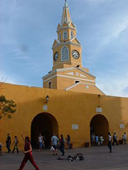
The official entrance to downtown is through Puerta del Reloj (Clock Gate), which comes out onto Plaza de los Coches (Square of the Carriages). A few steps from there there is the Plaza de la Aduana (Customs Square), next to the mayor's office. Nearby is San Pedro Claver Square, and his namesake's church, as well as the Museum of Modern Art. 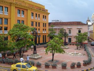
Nearby is the Plaza de Bolívar (Bolívar's Square) and the Palace of the Inquisition to one side. Nearby is the Plaza de Bolívar (Bolívar's Square) and the Palace of the Inquisition to one side. Plaza de Bolivar (formerly known as Plaza de Inquisicion) is more like a tiny park with a statue of Simon Bolivar in the center. This plaza is surrounded by some of the city's most elegant, balconied colonial buildings. Under shady terraces outdoor cafes line the street. Not to far is the office of Historical Archives which holds Cartagena's history. Next to the archives is the Government Palace, the office building of the Governor of the Department of Bolivar. Across from the palace is the Cathedral of Cartagena which dates back to the 16th century.

There is another religious temple that you should take time to admire: The restored Santo Domingo Church, in front of Plaza Santo Domingo (Santo Domingo Square). The square was decorated with the sculpture Mujer Reclinada ("Reclining Woman"), a gift from the renowned Colombian artist Fernando Botero.
Another notable building is the Teatro Heredia (Heredia Theater), an architectural jewel located in front of the Plaza de la Merced. A few meters away is the Calle de la Factoría (Factory Street); on it is the Marquis of Valdehoyos House which now functions as the Historical Photographic Library.
A little bit further on is Augustinian Fathers Convent is the University of Cartagena. This university is a higher education center, opened to the public in the late 19th century. The Claustro de Santa Teresa (Saint Theresa Cloister), which has been remodeled into a hotel, operated by Charleston Hotels became an upscale Colombian hotel chain. It has its own square, protected by the San Francisco Bastion.
A twenty minute walk from the downtown is the Castillo de San felipe de Barajas. This is the greatest fortress ever to be built by the Spaniards in their colonies. The original fort was constructed between 1639 and 1657 ontop of the San Lazaro hill. In 1762 and extensive enlargement was undertaken and the result is the current powerful bastion. Numerous attempts were taken to storm the fort, though it was never overtaken. An extensive system of tunnels are connected underground to distribute provisions and facilitate evacuation. The tunnels were all constructed in such as way as to make it possible to hear the footsteps of an approaching enemy's feet. Some of the tunnels are open today and available to view with or without a guide. 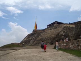
San Diego
It was named after San Diego Convent, nowadays the Beaux Arts School Building. In front of it you will find Convent of the Nuns of the Order of Saint Claire, now the beautiful Hotel Santa Clara. In the surrounding area you will find Santo Toribio Church, the last church built in the Walled City, and next to it, Fernández de Madrid Square, in honor of Cartagena's hero José Fernández de Madrid, whose statue can be seen here.
Inside the Old City, you have to go to Las Bóvedas (The Vaults), a construction attached to the walls in the Santa Catalina Bastion. From the top of this construction you will be able to view the Caribbean Sea.
The Matuna
The Matuna is the commercial and financial area par excellence in the city. Here you can also find affordable hotels, like Saint Philip Hotel, and affordable restaurants with good service.
Getsemaní neighborhood
This is one of the most representative neighborhoods in Cartagena. African people who were brought as slaves used to live here. Parque Centenario (Centennary Park) is the most prominent place in this area; built in 1911, it commemorates a century of independence.Inside, often obscured, you will find some interesting monuments, including one dedicated to the military. Parque Centenario also serves as a local police station and a mid afternoon pulpit for aspiring evangelists. Over the years, the park has acquired, through various means, a sloth, two Gila Monsters and a few monkeys. The Eastern edge of the park is split between a really good used book pavilion (with English books stowed away for the industrious traveller) and a selection of Seafood joints. Their seafood kiosks are often stocked by homeless folk fishing and bringing them to the various kiosks. This would cause a wary traveller to think twice before eating at one of these. On the other hand, these kiosks all run 24 hours, so there is always food available. In this very same area you will find Cartagena's Convention Center, Third Order Church and San Francisco Cloister. You will also see San Roque and of the Trinity churches, in the square with the same name. Note that the entirety of the Old City has the same architectural styles as the area surrounded by The Walls.

There is a great boutique hotel in this neighborhood called Casa El Carretero. It has been featured on the New York times and Travel & Leisure.
Bocagrande
Bocagrande (Big Mouth) is the most modern area of the city, with many hotels, shops, restaurants, nightclubs and art galleries. It forms part of a land extension delimited by Cartagena Bay to the east and the Caribbean Sea to the west, where you will find El Laguito (The Little Lake) and Castillogrande (Big Castle), two renowned neighborhoods. Its particular appeal are the beaches and nightlife. All over Avenida San Martín (Saint Martin Avenue), which is the backbone of the area, you will find several business premises, restaurants and hotels. Along the BocaGrande beach lies the Hotel Caribe. This 11,486 square foot resort was contructed with colonial architechture and is surrounded by exoctic gardens, swimming pools and views of the bay. People from all over the world enjoy the amenaties of this beautiful hotel.
The beaches of BocaGrande, laying along the Northern shore, are muddy affairs. There are breakwaters about every two hundred yards and the desired azure of the Caribbean is lost by the almost sea level rise of the beach and the lack of proper waste disposal in the city. It takes about seven minutes worth of a boat ride out to sea to see the color that you desire of the Caribbean.
On the bay side of the pensinsula of Boca Grande is a spectacular seawalk. The centre of the Bay holds a statue of the Virgin Mary. The seawalk is the site of an interesting showing of the various contestants of the Miss Colombia Pageant during that festival.
Originally constructed for foreign oil workers, the majority of the land which makes up Bocagrande was established through land reclamation. Bocagrande is now considered the city's most popular area for tourists.
Further information
To know more about the city's government history see:
- List of Mayors of Cartagena de Indias
- List of Governors of the Province of Cartagena
Touristic Sites and Attractions
Just to name a few:

- Islas del Rosario
- India Catalina
- Steps of La Popa mount
- El Castillo de San Felipe
- The Walled city of Cartagena
- El Cartagena Gold Museum
- The Palace of the Inquisition
- Las Bóvedas
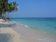
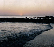
- Playa Blanca, Barú (located in the island of Barú)
Architecture
Cartagena has experienced heavy urban development in recent years, particularly with the construction of new skyscrapers. As of October 2007, there were 42 high-rises under construction, including an effort to create Colombia's tallest, the Torre de la Escollera. The new high-rise, extraordinarily narrow, was expected to be completed in early 2007, and was planned to stand at 676 ft (206 m) and have 58 floors. However, a construction defect, accentuated by the strong Caribbean winds, has led to its dismantling. A new, twenty-story building will be constructed in its place. The building reached the 56th floor (in girders, solely) before the wind bent the structure severely.
Transportation
As the commercial and touristic hub of the country the city has many transportation facilities, particularly in the seaport, air, and fluvial areas.
Land transportation
The city is linked to the nortern part of the Caribbean Region through roads 90 and 90A, more commonly called Central Caribbean Road. This Road passes through Barranquilla, Santa Marta and Riohacha ending in Paraguachón, Venezuela and continues with venezuelan numeration all the way to Caracas.
To the southeast the city has more entrances:
Road 25: Going through Turbaco and Arjona, and through the Montes de María when a fork divides it continuing to Sincelejo as National 25 and finally ending in Medellín, and to the east to Valledupar as number 80.
Road 25 A: Going also to Sincelejo, but avoiding the mountains, finally connects with 25 in the forementioned city.
Air transportation
The city is served by Rafael Núñez International Airport, the biggest and busiest airport in the region and the second in passenger traffic in the country. The code of the airport is CTG, having flights to almost all the airports in the country and many connections to Eldorado International Airport in Bogota. Though, because of excesive operational costs and easier connections and better prices, it has been shifting the gross international connection passengers to the nearer Tocumen International Airport in Panama and Queen Beatrix International Airport in Aruba while also more companies prefer to serve the colombian market from Cartagena de Indias, due to better geographical and atmospherical conditions.
This growing general air traffic shift from the interior to this coastal airport, studies had been made to build a bigger new airport in the area of Barbacoas Bay in the southern city limits. This airport, if aproved may be finished by 2020, the proyect favored by many in the region and others parts of the country as economically convenient is recelled in Bogotá and is in a standstill.
Railroad transportation
The city used to have railroad station near today's "La Matuna" Neighborhood, but in the late 50s was a general movement from central government to dismount the railroad system and replace it with paved roads, in general, Colombia lacks today of consistent railroad infrastructure.
Sea transportation
As the busiest container port in the country, and 3rd. in grain transportation, the city is well connected with the ports of the Caribbean main, and the rest of the world. The city is served with 3 open ports, and more than 40 private ports.

The open ports of the City are:
- Sociedad Portuaria de Cartagena de Indias (Port Society of Cartagena de Indias). Specialized in container management, the first of his class in the country, 3rd. busiest in the caribbean sea, and 99th ranked port in the world.[23]
- Muelles El Bosque (El Bosque Docks) Specialized in grain storage, expanding to the container market. [24]
- Terminal de Contenedores de Cartagena de Indias (Container Terminal of Cartagena de Indias) Container management.
Its important to note, that the first have adquired the assets of the last to develop a new port in the external bay that intends to duplicate the container capacity of the port in general by 2011 and triplicate it in 2015.

Of the private ports of the City we can mention:
- The port of the Glencore Cartagena de Indias Oil Refinery
- SAB-Miller brewery port.
- Argos cement port.
- Dow Chemical raw materials embarkment port
- BASF Colombia raw materials embarkment port
- Du Pont private embarkment port
- Cemex cement port.
- Dole Packing house
- Colombian Navy Steelworks port.
Fluvial transportation
Since the XVII century the bay is connected with the Magdalena river with the Dique Canal, built by the governor Pedro Zapata de Mendoza. After colombian independence the canal was abandonned and growing centralization left the city without resources to fund the vital artery, the last important maintenance works were made in the 50s during Laureano Gomez's administration, some improvements were made by local authorities in the 1980s but were insuficcient because of technical impediments from central government that said that the "maintenance" of the canal wasn't the local administration jurisdiction, from then, maintenance of the canal has stopped though it still works.[25]
Many caribbean and cartagenian political leaders argue that this state of affairs may change with a return to the pre-independence funding and tax system and the canal would be maintained properly and even expanded, benefiting in general the national economy.[26]
Distances
| City | Land distance | Aprox. Time by land | Aprox. Time by sea or river. | Aprox. Time by air |
|---|---|---|---|---|
| Barranquilla | 93 Km. | 1 h. | 10 h. | 15 min. |
| Santa Marta | 192 Km. | 2 h. 20 min | 14 h. | 25 min. |
| Sincelejo | 144 Km. | 2 h. 10 min | Not applicable | 15 min. |
| Montería | 256 Km. | 3 h. 45 min | Not applicable | 30 min. |
| Medellín | 689 Km. | 14 h. 50 min | Not applicable | 50 min. |
| Bogotá | 1092 Km. | 1 day, 4 h. 15 min | Not applicable | 1 h 05 min. |
| Caracas | 1234 Km. | 1 day 6 h. | Not applicable | 2 h. |
| Panama | 689 Km. | Not applicable | 4 days | 50 min. |
| Lima | 6830 Km. | 3 days, 2 h. | 1 week | 5 h 05 min. |
| Sydney | 30900 Km. | Not applicable | 3 weeks | 12 h. |
| Tokyo | 53000 Km. | Not applicable | 1 month | 23 h. |
| Buenos Aires | 15900 | 1 week, 5 days. | 4 weeks | 8 h. |
| Madrid | 19902 Km. | Not applicable | Not applicable | 8 h. |
| Paris | 24820 | Not applicable | Not applicable | 11 h. |
| New York | 10900 Km | Not applicable | 2 weeks | 4 h. |
Culture
If there is a city in Colombia that has a rich and vibrant cultural life is Cartagena de Indias, besides the somehow oversized tourism industry, the city offers many cultural and educational options for all publics and has been and still is the cultural capital of the nation.
Libraries
Cartagena de Indias was the seat of many private libraries since the XVIII century that were destroyed during the independence days. Today the city has many public and private libraries:
- The Universidad de Cartagena Jose Fernandez Madrid Library: Started in 1821 when the university opened as the "University of Magdalena and Ithsmus". Serves mainly the students and faculty of this university but anyone can use its services.
Its divided in buildings across the city being assigned to the Faculties it serves the most each area. The main building is in C. de la Universidad 64 and the second biggest section is located in Av. Jose Vicente Mogollón 2839. [27]
- The Bartolomé Calvo Library: Founded in 1843 and established in its actual place in 1900 is one of the main libraries of the Caribbean Coast and the biggest of the city. Its adress is: C. de la Inquisición, 23.
- The History Academy of Cartagena de Indias Library: Opened in 1903, but many of its books date from more than a century before from donations of members and benefactors. Its entrance is more restricted due to the care that the ancient books require, but it can be requested in the Academy office in Plaza de Bolivar 112.
- The Technological University of Bolívar Library: Opened in 1985 Although small in general size, its sections on engineering and electronics are inmense and its demand is mostly on this area, its located in Camino de Arroyohondo 1829.

- The American Hispanic Culture Library: Opened in 1999, it already existed a smaller version without Spanish funding in the Casa de España since the early 40s but in 1999 was enlarged to serve Latin America and the Caribbean in the old convent of Santo Domingo. It specializes on Hispanic Culture and History and is a continental epicenter of seminaries on history and restoration of buildings, the restoration of the convent and the enlargement of the library was and still is a personal proyect of Juan Carlos I of Spain who visits it regularly. Its located in Plaza Santo Domingo 30, but its entrance is in C. Gastelbondo 52.

- Jorge Artel Library: Opened in 1997, serves the area of the Southwest districts of the city, it is mostly for children. It is Located in Camino del Socorro 222
- Balbino Carreazo Library: Located in Pasacaballos, a suburban neighborhood of the southeastern part of the city, serves mostly the suburbs of Pasacaballos, Ararca, Leticia del Dique and Matunilla. It is located in Plaza de Pasacaballos 321
- District Libraries: Although small this system goes grassroots to neighborhoods circulating books, generally each district library has around 5000 books.[28]
Theatres and auditories
Performing arts have always been a big part of Cartagena's rich and varied cultural life. The first carnivals and western theaters that served in the New Grenada operated here, more precisely on today's Calle del Coliseo. This was an activity patronized by the Viceroy Manuel de Guirior and Antonio Caballero y Gongora who like their predecessors spent most of the time of their mandate ruling in Cartagena de Indias.
- Heredia Theatre: Opened in 1911, inspired by the Teatro Tacón of Havana was designed by Jose Enrique Jaspe. After years of abandonment, it was reborn in the 1990s and continues to be a hub in the cultural life in the city. If by chance there are not plays or concerts in the theater its posible to visit it just to see its paintings and lavishly wooden decorated seats and sections. It is located in Plazuela de La Merced 5. [29]
 Teatro Heredia was opened in 1911 and restored in 1989
- Universidad de Cartagena Aula Maxima: Although in existence since the early 1800s, its use mainly for debates began in the late 1920s and it still has that use today. Its address is the same as the University library.
- Cartagena de Indias Convention Center: The biggest in Colombia has one main auditorium with 19,300 seats and more than 50 small rooms for conferences, also has other rooms like the Bahia de las Animas rooms capable to host small concerts and boxing matches with 4000 people capacity. Its Located in C. del Arsenal 2
- Las Americas Convention Center: Recently opened, has a main room for 7,000 people and 10 small conference rooms for 100 people each, Its located in Paseo de las Americas 320.
- The city has 32 commercial cinemas and 12 foreign cultural centers that show movies from each country. In September each year, the league of these cultural centers organizes a festival of European movies.
- The city has registered more than 100 companies of theater, traditional or contemporary dancing and its regularly visited by ballet and opera companies. Many of these local theater and traditional companies have their own auditoriums. To name some of them: Reculá del Ovejo House, Teatro Contemporaneo Cartagenero, Ekobios and Colegio del Cuerpo.
Museums and Galleries
As a World Heritage Site, is somehow absurd to name museums in Cartagena de Indias when the city is a museum itself. Anyway, here we list museums that the city has to offer and others that are in project.
- City Museum Palace of the Inquisition: It was opened in the 70s
World Heritage site
| Port, Fortresses and Group of Monuments, Cartagena* | |
|---|---|
| UNESCO World Heritage Site | |
 |
|
| State Party | |
| Type | Cultural |
| Criteria | iv, vi |
| Reference | 285 |
| Region** | Latin America and the Caribbean |
| Inscription history | |
| Inscription | 1980 (8th Session) |
| * Name as inscribed on World Heritage List. ** Region as classified by UNESCO. |
|
The Port, Fortresses and Group of Monuments of Cartagena were selected in 1984 by the United Nations Educational, Scientific and Cultural Organization for being located in a bay by the Caribbean Sea, having the most extensive fortifications in South America. A system of zones that divides the city into three neighborhoods: San Sebastian and Santa Catalina with the cathedral and many palaces where the wealthy lived and the main government buildings functioned; San Diego or Santo Toribio, where merchants and the middle class lived; and Getsemani, the suburban popular quarters.[30]
In Popular Culture
- Cartagena gained modern notoriety in the 1984 hit movie, Romancing the Stone when romance novelist Joan Wilder (Kathleen Turner) travels to Cartagena to deliver a treasure map in an effort to ransom her kidnapped sister. The Cartagena scenes were actually filmed in Mexico, and it doesn't reflect the real Cartagena. In the Family Guy episode Barely Legal, the mayor, thinking the film to be real, sends all the police officers to Cartagena, which is referred to as being a fictional city.
- In that movie, Michael Douglas' character refers to it as Cartage(ny)a. This has largely been adopted by tourists and is a constant thorn in the sides of locals. The "N" in Cartagena is solid. You will find only one business in the entire city that refers to this film.
- Gabriel García Marquez's novel Love in the Time of Cholera although is set in an unnamed city, it is obviously Cartagena. Also in Cartagena, partially or totally are set other novels of his, like The General in his Labyrinth and Strange Pilgrims.
- The first chapter of Brian Jacques' novel The Angel's Command takes place in 1628 Cartagena.
- The movie Love in the Time of Cholera released on November 16, 2007 in the USA, is filmed in Cartagena.
- La Queimada, "Burn!" with Marlon Brando was filmed in Cartagena and released in 1969.
- The movie "The Mission (film)" released in 1986 with Robert De Niro was filmed in Cartagena and Brazil. The interpreter for the director was a Colombian who had recently moved to Canada.
- The poem “Románc” by Sándor Kányádi is talking about the beauty of Cartagena.
- Cartagena is referred to by Tom Cruise's character, Vince, in a scene in the film Collateral just before he terminates the blues trumpet player.
- A fictionalized version of the raid on Cartagena is chronicled in Chapter 27 in the novel Captain Blood.
Nearby Towns and Cities
 |
Caribbean Sea | Caribbean Sea, Bocacanoa | Bayunca, Clemencia |
|
|||
| Caribbean Sea | Timiriguaco, San Estanislao | ||||||
| Caribbean Sea | Caribbean Sea, Tierrabomba, Portonao. | Turbaco, Arjona |
Sister cities
|
References
- ↑ "X Cátedra de Historia Ernesto Restrepo Tirado - "El Caribe en la Nación Colombiana" Guerra, Langbaek et al. Ed. Aguilar, Bogotá, 2007. ISBN 958-8250-31-5.
- ↑ Allaire, Louis (1997). "The Caribs of the Lesser Antilles". In Samuel M. Wilson, The Indigenous People of the Caribbean, pp. 180–185. Gainesville, Florida: University of Florida. ISBN 0-8130-1531-6.
- ↑ 3.0 3.1 Biblioteca Luis Ángel Arango
- ↑ http://pwp.supercabletv.net.co/garcru/colombia/Colombia/indios.html
- ↑ 5.0 5.1 http://www.uninorte.edu.co/divisiones/humanidades/arqueologia/proyectos/pro_pag_13-06.html
- ↑ http://www.lablaa.org/blaavirtual/publicacionesbanrep/boletin/boleti3/bol12/debate.htm
- ↑ The names of the periods of these monticles were chosen randomly according to the name of nearby towns
- ↑ Lemaitre, Eduardo; Historia Extensa de Cartagena de Indias, Ed. Aguilar 1976. Edited before the ISBN system was enforced in Colombia, no reedition.
- ↑ http://www.bruceruiz.net/PanamaHistory/diego_de_nicuesa.htm
- ↑ http://www.britannica.com/EBchecked/topic/55612/Rodrigo-de-Bastidas
- ↑ http://www.bruceruiz.net/PanamaHistory/rodrigo_de_bastidas.htm
- ↑ Lemaitre, Eduardo; Historia Extensa de Cartagena de Indias, Ed. Aguilar 1976.
- ↑ Corrales, Manuel Ezequiel; Documentos para la historia de la Provincia de Cartagena, Tomo II, Imp. M. Rivas, Cartagena de Indias, 1883.
- ↑ http://www.lablaa.org/blaavirtual/revistas/credencial/marzo1992/marzo3.htm
- ↑ De Castellanos, Juan; Historia de Cartagena, Bogotá, Biblioteca de Cultura Popular de Colombia, 1942.
- ↑ http://ageofpirates.com/article.php?Port_of_Cartagena
- ↑ http://www.cervantesvirtual.com/servlet/SirveObras/05816284255727262232268/index.htm
- ↑ http://www.spartacus.schoolnet.co.uk/TUDhawkinsJ.htm
- ↑ http://www.timesonline.co.uk/tol/news/world/article677647.ece
- ↑ http://www.banrep.gov.co/docum/Pdf-econom-region/Cuadernos/CHEE09.pdf
- ↑ http://www.loc.gov/rr/rarebook/catalog/drake/drake-6-caribraid.html
- ↑ www.ideam.gov.co
- ↑ http://www.puertocartagena.com/
- ↑ http://www.elbosque.com/
- ↑ Lemaitre, Eduardo; Historia Extensa de Cartagena de Indias, Ed. Aguilar 1976
- ↑ "El Porvenir", Year CXVII, Issue 29.399, Page 4, column 2. Cartagena de Indias, 1999.
- ↑ http://www.unicartagena.edu.co/biblioteca.htm
- ↑ http://www.ipcc.gov.co/bibliotecas.html
- ↑ http://www.cartagenatravel.com/espanol/teatroheredia.htm
- ↑ UNESCO: Cartagena, Colombia
External links
Cartagena de Indias travel guide from Wikitravel
- (Spanish) http://www.alcaldiadecartagena.gov.co/ Cartagena City Government website
- (Spanish) http://www.turismocartagenadeindias.com/es/general.htm Cartagena de Indias Bureau of Tourism
- (Spanish) http://www.cartagenatravel.com/
- Library of Congres - United States: Cartagena, Colombia Library of Congress summary on Cartagena de Indias
- (Spanish) http://www.lablaa.org/blaavirtual/historia/sitio/sitio22.htm Luis Angel Arango Library: History of Cartagena]
- 2006 Official Website
- (Spanish) http://gematours.com/hayfestival/es/
- (Spanish) http://www.CasaElCarretero.com
- (Spanish) http://www.fortificacionesdecartagena.com/ Cartagena de Indias Benefic Works Society[1]
|
|||||||||||||||||||||||||||||||||||||||||||||||||||||
|
|||||||
|
|||||||
|
|||||
|
|||||
|
|||||