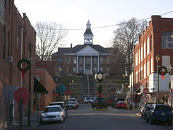
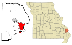
Cape Girardeau, Missouri
| Cape Girardeau, Missouri | |
 |
|
| Nickname(s): Cape, The City of Roses | |
 |
|
| Coordinates: | |
| Country | United States |
|---|---|
| State | Missouri |
| Counties | Cape Girardeau, Scott |
| Government | |
| - Mayor | Jay Knutdson (R) |
| Area | |
| - Total | 24.3 sq mi (63.0 km²) |
| - Land | 24.3 sq mi (62.9 km²) |
| - Water | 0.1 sq mi (0.1 km²) |
| Elevation | 351 ft (107 m) |
| Population (2000) | |
| - Total | 35,349 |
| - Density | 1,456.5/sq mi (562.4/km²) |
| Time zone | Central (CST) (UTC-6) |
| - Summer (DST) | CDT (UTC-5) |
| ZIP Code | 63701, 63702, 63703, 63705 |
| Area code(s) | 573 |
| FIPS code | 29-11242[1] |
| GNIS feature ID | 0731549[2] |
| Website: http://www.cityofcapegirardeau.org/ | |

Cape Girardeau (pronounced /ˈkeɪp dʒɨˈrɑrdoʊ/) (French: Cap-Girardeau, pronounced ![]() [kap ʒiʀaʀdo]) (colloquially referred to as "Cape") is a city located in the county of the same name in Southeast Missouri, 115 miles (185 km) south of St. Louis. As of the 2000 U.S. Census, the city's population was 35,349. The Cape Girardeau-Jackson, MO-IL Micropolitan Statistical Area embraces Alexander County, Illinois, Bollinger County, Missouri and Cape Girardeau County, Missouri. A booming college town, it is the home of Southeast Missouri State University. Although it is the largest town in Cape Girardeau County, the county seat is actually Jackson, Missouri.
[kap ʒiʀaʀdo]) (colloquially referred to as "Cape") is a city located in the county of the same name in Southeast Missouri, 115 miles (185 km) south of St. Louis. As of the 2000 U.S. Census, the city's population was 35,349. The Cape Girardeau-Jackson, MO-IL Micropolitan Statistical Area embraces Alexander County, Illinois, Bollinger County, Missouri and Cape Girardeau County, Missouri. A booming college town, it is the home of Southeast Missouri State University. Although it is the largest town in Cape Girardeau County, the county seat is actually Jackson, Missouri.
Contents |
History
The city is named after Jean Baptiste de Girardot, who established a temporary trading post in the area around 1733; he was a French soldier stationed at Kaskaskia, Illinois, 1704-1720. The 'Cape' in the city name was a rock promontory overlooking the Mississippi River, later destroyed by railroad construction. As early as 1765, a bend in the Mississippi River about 60 miles south of the French village of Ste. Genevieve had been referred to as Cape Girardot or Girardeau. The settlement there dates from 1793 when the Spanish government, which had secured Louisiana in 1762, granted Louis Lorimier, a French-Canadian, the right of establishing a trading post. His grant gave him extensive trading privileges and a large tract of land surrounding his post. Lorimier was made commandant of the district and prospered from the returns on his land sales and trade with indigenous peoples such as the Ozark Bluff Dwellers and the Mississippian. The town of Cape Girardeau was incorporated in 1808, prior to Missouri statehood, and was reincorporated as a city in 1843. The advent of the steamboat in 1835 led it to become the biggest port on the Mississippi River between Saint Louis and Memphis.
The Civil War Battle of Cape Girardeau took place April 26, 1863. The Union and Confederate armies collided in a fierce, four-hour artillery barrage on this day in which 23 Union and 30 Confederate soldiers were killed. Today, Cape Girardeau is home to numerous Civil War sites and memorials such as:
- Fort D
- Old Lorimier Cemetery
- Common Pleas Courthouse
- Confederate War Memorial
- Minton House
Reflecting the area's rich appreciation of history, numerous murals create a beautiful backdrop to some of the city's most charming areas. The largest, and most dramatic of these, is the Mississippi River Tales Mural, located on the city's downtown floodwall. Covering nearly 18,000 square feet, this mural spans the length of the downtown shopping district and features 24 panels that tell the tales of Cape Girardeau and the mighty Mississippi River. Behind the floodwall lies the Riverfront Park of Cape Girardeau Missouri, where riverboats dock and visitors can view the lazy Mississippi River.
The city is also known to some as "The City of Roses" because of a nine-mile (14 km) stretch of highway that was once lined with dozens of rose bushes. Although there used to be many prominent rose gardens around the community, few of these gardens persist today. In December 2003, a new four-lane cable-stay bridge crossing the Mississippi River at Cape Girardeau was opened. Its official name is "The Bill Emerson Memorial Bridge.", named in honor of former U.S. Rep. Bill Emerson (R-Mo.) who led the fight in Congress to appropriate federal funding for the bridge's construction. The two towers of the bridge reach a height of approximately 91 meters. The "Old Bridge was completed in September 1928 to replace a ferry and was only 20 feet (6.1 m) wide.[3] It was demolished after the completion of the Bill Emerson Bridge.

The City of Cape Girardeau was recognized in January 2008 by First Lady Laura Bush as a Preserve America Community.[4]
Geography
Cape Girardeau is located at (37.309042, -89.546498)[5]. According to the U.S. Census Bureau, the city has a total area of 26.4 sq mi (16,875 acres or 68.4 km²). The "cape" that the city is named after no longer exists. A rock which remains from the previously existing cape can be seen on a promontory which overlooks the Mississippi River in Cape Rock Park.
Demographics
As of the census[1] of 2000, there were 35,349 people, 14,380 households, and 8,297 families residing in the city. The population density was 1,456.5 people per square mile (562.4/km²). There were 15,827 housing units at an average density of 652.1/sq mi (251.8/km²). The racial makeup of the city was 87.32% White, 9.30% Black or African American, 1.13% Asian, 0.39% Native American, 0.04% Pacific Islander, 0.43% from other races, and 1.40% from two or more races. Hispanic or Latino of any race were 1.10% of the population.
There were 14,380 households out of which 25.7% had children under the age of 18 living with them, 43.8% were married couples living together, 10.9% had a female householder with no husband present, and 42.3% were non-families. 33.6% of all households were made up of individuals and 11.5% had someone living alone who was 65 years of age or older. The average household size was 2.24 and the average family size was 2.90.
The age distribution is 20.5% under the age of 18, 18.4% from 18 to 24, 25.6% from 25 to 44, 19.9% from 45 to 64, and 15.5% who were 65 years of age or older. The median age was 34 years. For every 100 females there were 89.5 males. For every 100 females age 18 and over, there were 86.9 males.
The median income for a household in the city was $32,452, and the median income for a family was $43,917. Males had a median income of $31,575 versus $21,392 for females. The per capita income for the city was $18,918. About 8.5% of families and 15.2% of the population were below the poverty line, including 16.5% of those under age 18 and 8.6% of those age 65 or over.
Four of the largest employers in Cape Girardeau are Southeast Missouri Hospital, Saint Francis Medical Center, Procter and Gamble, and Southeast Missouri State University.
Health and Education
The city is served by two major medical centers, St. Francis Medical Center and Southeast Missouri Hospital. There are three major school systems in the city: Cape Girardeau Public Schools (including Cape Central High School), the Roman Catholic Church-run private schools (including Notre Dame Regional High School), and Southeast Missouri State University. The city features several fitness centers and a walking/biking trail as well as indoor and outdoor public sporting complexes.
Politics
Although Cape Girardeau is the largest city in Missouri’s 8th Congressional District and is full of upper middle class citizens, the city and county itself are Republican strongholds especially in federal elections. In Election 2008, Sen. John McCain (R-Arizona) carried Cape Girardeau County by a convincing 2-to-1 margin over Sen. Barack Obama (D-Illinois), 66.30-32.68 percent. Four years earlier, President George W. Bush trumped Sen. John Kerry (D-Massachusetts) 68.90-30.57 percent in Cape Girardeau County. The last Democratic presidential nominee to win Cape Girardeau County was Lyndon B. Johnson in 1964.
In the 2008 presidential primaries, Cape Girardeau County was the only county in Missouri’s 8th Congressional District won by former Governor Mitt Romney (R-Massachusetts) over former Governor Mike Huckabee (R-Arkansas) who carried almost every other county in Southeast Missouri and John McCain who ultimately won the state. On the Democratic side, Sen. Hillary Rodham Clinton (D-New York) carried Cape Girardeau County with a solid 56.55 percent of the vote over Barack Obama’s 39.44 percent. Clinton’s margin of victory in Cape Girardeau County, though, was one of her weaker showings considering that in virtually all of the rural parts of the state she often received anywhere from the upper 60s to lower 70 percent of the vote. Obama may have been able to siphon off some votes from Clinton in Cape Girardeau County because of the college subplot in Southeast Missouri State University and/or from the city’s modest African American population.
The City and County of Cape Girardeau is a part of Missouri’s 8th Congressional District and is served in the U.S. House of Representatives by Jo Ann Emerson (R) who has held the seat since 1997 following the special election to succeed her late husband Bill Emerson. Since then, Emerson has won six easy and solid reelections to the seat, receiving at and above 70 percent of the vote. The last Democrat to represent MO-08 was Bill Burlison who held the seat from 1968-1980.
At the state level, most of the City of Cape Girardeau is a part of Missouri’s 156th Legislative District and is currently served by State Representative Mary Kasten (R). Kasten won the February 5, 2008 special election with 50 percent of the vote over postmaster Mike Keefe’s (D) 43 percent in a bid to succeed former State Representative Nathan Cooper (R) who pleaded guilty to immigration fraud in August 2007. The lopsidedness of the city’s political culture led no Democrat to run in this year’s election to succeed Kasten. Clint Tracy (R), son of Cape Girardeau City Councilwoman Debra Tracy, clinched the Republican nomination in the August 5, 2008 primary over Wayne Wallingford (R) and Jeff Glenn (R) and then went on to defeat Robert Roland, the Libertarian candidate, with 76.3 percent of the vote.
Cape Girardeau Mayor Jay Knutdson is also a Republican.
Transportation
Cape Girardeau Regional Airport serves the city. Cape Girardeau is also served by Interstate 55 and an Interstate business loop, known locally as "Kingshighway." Cape Girardeau County Transit Authority provides public transportation of the city with buses and taxis. The Shuttle system operates out of Southeast Missouri State University to transport college students who do not have a vehicle to various destinations in the city.

In popular culture
The James McMurtry's Song for a Deck Hand's Daughter is set in Cape Girardeau. The book Killshot by Elmore Leonard is partly set in Cape Girardeau. In January 2006, some scenes were shot on location for the movie adaptation starring Diane Lane, Thomas Jane, Johnny Knoxville, and Mickey Rourke. However, these scenes were cut from the final film.
Notable people
- Chic Hecht, US Senator from Nevada
- Rush Limbaugh, talk radio host
- Rush Limbaugh, Sr. (1891–1996), lawyer and civic leader; grandfather of the radio host
- David Limbaugh, lawyer
- Stephen N. Limbaugh, Jr., Missouri Supreme Court Judge
- Dale Dye, actor
- Terry Teachout, writer
- Andrew Conway Ivy, (1893-1978), president of the American Physiological Society (1939-41)
- Mark Littell, baseball player (St. Louis Cardinals, Kansas City Royals)
- Billy Swan, singer who had a #1 hit song named I Can Help in 1974.
References
- ↑ 1.0 1.1 "American FactFinder". United States Census Bureau. Retrieved on 2008-01-31.
- ↑ "US Board on Geographic Names". United States Geological Survey (2007-10-25). Retrieved on 2008-01-31.
- ↑ Mary Charlotte Aubry Costello (1995). Climbing the Mississippi River Bridge by Bridge. Mary C. Costello. p. 48. 0-9644518-1-6.
- ↑ Preserve America Community
- ↑ "US Gazetteer files: 2000 and 1990". United States Census Bureau (2005-05-03). Retrieved on 2008-01-31.
External links
- City's official website
- Convention & Visitors Bureau
- Southeast Missourian newspaper
- Cape Girardeau Public Schools
- CapeGirardeau.com City Guide
- Cape Girardeau, Missouri is at coordinates
|
|||||||||||||||||||||||

|