Cape Cod
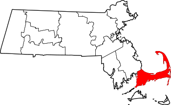
Cape Cod (or simply the Cape to most New Englanders) is a peninsula nearly coextensive with Barnstable County, Massachusetts[1] and forming the easternmost portion of the state of Massachusetts, in the Northeastern United States. The Cape's small town character and beachfront brings heavy tourism during the summer months.
Although the Cape was originally connected to the mainland, the Cape Cod Canal, which opened in 1914, technically transformed Cape Cod into a large island (though it is not normally referred to as such). Three bridges span the canal from the Massachuetts mainland to the Cape. Vehicles can cross onto the Cape via the Sagamore Bridge and the Bourne Bridge; the other is the Cape Cod Canal Railroad Bridge.
Contents |
Geographic and political divisions

Cape Cod comprises almost all of Barnstable County. Two of the county's fifteen towns (Bourne and Sandwich) include land on the mainland, "off-Cape", side of the canal. The towns of Plymouth and Wareham, in adjacent Plymouth County, are sometimes confused to be part of Cape Cod but are not located on the peninsula, and the 1914 completion of the Cape Cod Canal separated them from the towns on the Cape proper. "Cape Codders", or people who live "on Cape", generally refer to all land on the mainland side of the canal as "off-Cape."
Cape Cod consists of four portions:
- The Upper Cape is the section of Cape Cod closest to the mainland. This portion of the Cape includes the towns of Bourne, Sandwich, Falmouth, and Mashpee. While part of the town of Barnstable is located on the Upper Cape, it is more commonly considered to be in the Mid-Cape area. Falmouth is the home of the famous Woods Hole Oceanographic Institution and several other research organizations, and is also the most-used ferry connection to Martha's Vineyard. Falmouth is composed of several separate villages, including East Falmouth, Falmouth Village, Hatchville, North Falmouth, Teaticket, Waquoit, West Falmouth, and Woods Hole, as well as several smaller hamlets that are incorporated into their larger neighbors (e.g., Davisville, Falmouth Heights, Quissett, Sippewissett, and others).[3]
- The Mid-Cape includes the towns of Barnstable, Yarmouth and Dennis. The Mid-Cape area features many beautiful beaches, including warm-water beaches along Nantucket Sound, e.g. Kalmus Beach in Hyannis, which gets its name from one of the inventors of Technicolor, Herbert Kalmus. This popular windsurfing destination was bequeathed to the town of Barnstable by Dr. Kalmus on condition that it not be developed, possibly one of the first instances of open-space preservation in the US. The Mid-Cape is also the commercial and industrial center of the region. There are seven villages in Barnstable, including Barnstable Village, Centerville, Cotuit, Hyannis, Marstons Mills, Osterville, and West Barnstable, as well as several smaller hamlets that are incorporated into their larger neighbors (e.g., Craigville, Cummaquid, Hyannisport, Santuit, Wianno, and others).[4] There are three villages in Yarmouth: South Yarmouth, West Yarmouth and Yarmouthport.

- The Lower Cape is the narrower portion of the cape, where it bends sharply to the north. This section includes the towns of Harwich, Brewster, Chatham, and Orleans.
- The Outer Cape is the outermost part, containing the towns of Eastham, Wellfleet, Truro, and Provincetown. This area includes the Cape Cod National Seashore, a national park comprising much of the outer Cape, including the entire east-facing coast, and is home to some of the most popular beaches in America, such as Coast Guard Beach and Nauset Light Beach in Eastham. Stephen Leatherman aka "Dr. Beach" recently named Coast Guard Beach the 5th best beach in America for 2007.[5]
The large area of water spanning from Plymouth to Provincetown, bordered to the north by Massachusetts Bay and enclosed by Cape Cod, is Cape Cod Bay; west of Cape Cod is Buzzards Bay. To the south lie Nantucket Sound; Nantucket and Martha's Vineyard (both large islands); and the mostly privately owned Elizabeth Islands in the town of Gosnold, of which the most populated is Cuttyhunk.
The highest elevation on Cape Cod is 306 feet (93 m), at the top of Pine Hill, in the Bourne portion of the Massachusetts Military Reservation. The lowest point is sea level.
Geology
"East of America, there stands in the open Atlantic the last fragment of an ancient and vanished land. Worn by the breakers and the rains, and disintegrated by the wind, it still stands bold." - Henry Beston, from his book The Outermost House


Cape Cod forms a continuous archipelagic region with a thin line of islands stretching toward New York, historically known by naturalists as the Outer Lands. This continuity is due to the fact that the islands and Cape are all terminal glacial moraines laid down some 16,000 to 20,000 years ago.
Most of Cape Cod's geological history involves the advance and retreat of the Laurentide ice sheet in the late Pleistocene geological era and the subsequent changes in sea level. Using radiocarbon dating techniques, researchers have determined that around 23,000 years ago, the ice sheet reached its maximum southward advance over North America, and then started to retreat. Many "kettle ponds" — clear, cold lakes — were formed on Cape Cod as a result of the receding glacier. By about 18,000 years ago, the ice sheet had retreated past Cape Cod. By roughly 15,000 years ago, it had retreated past southern New England. When so much of Earth's water was locked up in massive ice sheets, the sea level was lower. Truro's bayside beaches use to be a petrified forest, before it became a beach.
As the ice began to melt, the sea began to rise. Initially, sea level rose quickly, about 15 meters (50 feet) per 1,000 years, but then the rate declined. On Cape Cod, sea level rose roughly 3 meters (11 feet) per millennium between 6,000 and 2,000 years ago. After that, it continued to rise at about 1 meter (3 feet) per millennium. By 6,000 years ago, the sea level was high enough to start eroding the glacial deposits that the vanished continental ice sheet had left on Cape Cod. The water transported the eroded deposits north and south along the outer Cape's shoreline. Those reworked sediments that moved north went to the tip of Cape Cod.
Provincetown Spit, at the northern end of the Cape, consists largely of marine deposits, transported from farther up the shore. Sediments that moved south created the islands and shoals of Monomoy. So while other parts of the Cape have dwindled from the action of the waves, these parts of the Cape have grown.
This process continues today. Due to their position jutting out into the Atlantic Ocean, the Cape and islands are subject to massive coastal erosion. Geologists say that, due to erosion, the Cape will be completely submerged by the sea in thousands of years.[6] This erosion causes the washout of beaches and the destruction of the barrier islands; for example, the ocean broke through the barrier island at Chatham during Hurricane Bob in 1991, allowing waves and storm surges to hit the coast with no obstruction. Consequently, the sediment and sand from the beaches is being washed away and deposited elsewhere. While this destroys land in some places, it creates land elsewhere, most noticeably in marshes where sediment is deposited by waters running through them.
Climate
Cape Cod has a temperate marine climate. Although Cape Cod's weather[7] is typically more moderate than inland locations, there have been occasions where Cape Cod has dealt with the brunt of extreme weather situations (such as the Blizzard of 2005 and Hurricane Bob). Because of the influence of the Atlantic Ocean, temperatures are typically a few degrees cooler in the summer and a few degrees warmer in the winter. A common misconception is the climate is influenced largely by the warm Gulf Stream current, however that current turns eastward off the coast of Virginia and the waters off the Cape are more influenced by the cold Canadian Labrador Current. The Cape's climate is also notorious for a delayed spring season, being surrounded by an ocean which is still cold from the winter; however, it is also known for an exceptionally mild fall season (Indian summer), thanks to the ocean remaining warm from the summer. The highest temperature ever recorded on Cape Cod was 104 °F (40 °C) in Provincetown[8], and the lowest temperature ever was -12 °F (-24 °C) in Barnstable.[9]
The water surrounding Cape Cod moderates winter temperatures enough to extend the USDA hardiness zone 7a to its northernmost limit in eastern North America.[10] Even though zone 7a (annual low = zero to 5 degrees Fahrenheit) signifies no sub-zero temperatures annually, there have been several instances of temperatures reaching a few degrees below zero across the Cape (although it is rare, usually 1-5 times a year, typically depending on locale, sometimes not at all). Consequently, many plant species typically found in more southerly latitudes grow there, including Camellias, Ilex opaca, and Albizia julibrissin.
Precipitation on Cape Cod and the islands of Martha's Vineyard and Nantucket is the lowest in New England region, averaging slightly less than 40 inches a year (most parts of New England average 42-46 inches). This is due to storm systems which move across western areas, building up in mountainous regions, and dissipating before reaching the coast where the land has leveled out. The region does not experience a greater number of sunny days however, as the number of cloudy days is the same as inland locales, in addition to increased fog.
| Month | Jan | Feb | Mar | Apr | May | Jun | Jul | Aug | Sep | Oct | Nov | Dec | Year |
|---|---|---|---|---|---|---|---|---|---|---|---|---|---|
| Avg high °F (°C) |
35.7 (2.1) |
36.5 (2.5) |
43.2 (6.2) |
53.1 (11.7) |
62.5 (16.9) |
74.3 (23.5) |
79.5 (26.3) |
80.0 (26.7) |
77.1 (25.2) |
65.1 (18.4) |
54.6 (12.6) |
41.8 (5.4) |
58.5 (14.7) |
| Avg low °F (°C) |
22.4 (-5.3) |
23.0 (-5.0) |
29.6 (-1.3) |
36.9 (2.7) |
47.7 (8.7) |
58.3 (14.6) |
66.6 (19.2) |
68.5 (20.3) |
60.0 (15.5) |
49.9 (9.9) |
39.1 (3.9) |
28.0 (-2.2) |
44.1 (6.7) |
| Rainfall in inches (millimeters) |
3.86 (98.0) |
2.97 (75.4) |
3.74 (95.8) |
3.62 (90.4) |
3.29 (80.3) |
3.02 (74.2) |
2.45 (62.2) |
2.56 (67.6) |
2.94 (75.9) |
3.34 (81.3) |
3.57 (90.7) |
3.65 (92.7) |
39.01 (990.85) |
Native population
Cape Cod has been the home of the Wampanoag tribe of Native American people for many centuries. They survived off the sea and were accomplished farmers. They understood the principles of sustainable forest management, and were known to light controlled fires to keep the underbrush in check. They helped the Pilgrims who arrived in Fall 1620, to survive at their new Plymouth Colony.
The Natives eventually lost their lands through purchase and expropriation by the British colonists. Currently, there are no Indian reservations on Cape Cod. The documentary Natives of the Narrowland (1993, narrated by actress Julie Harris) shows the history of the Wampanoag peoples through the lens of Cape Cod archaeological sites. In 1974, the Mashpee Wampanoag Tribal Council Inc. was formed to articulate the concerns of those with Native American ancestry. The federal government was petitioned in 1975 and again in 1990 for official recognition of the Mashpee Wampanoag as a "tribe". In May 2007, the Wampanoag tribe was finally federally recognized as a tribe.[11]
History

Cape Cod was a landmark for early explorers, possibly the "Promontory of Vinland" mentioned by the Norse voyagers (985-1025). Giovanni da Verrazzano in 1524 approached it from the south, and Esteban Gómez the next year called it Cape St. James. Bartholomew Gosnold in 1602 gave it the name that survives. Samuel de Champlain charted its sand-silted harbors in 1606 and Henry Hudson landed there in 1609. Captain John Smith noted it on his map of 1614 and at last the Pilgrims entered the "Cape Harbor" and--contrary to the popular myth of Plymouth Rock--made their first landing near present-day Provincetown on November 11, 1620. Nearby, in what is now Eastham, they had their first encounter with Native Americans.
Cape Cod was among the first places settled by Europeans in North America. Aside from Barnstable (1639), Sandwich (1637) and Yarmouth (1639) the Cape's fifteen towns developed slowly. The final town to be established on the Cape was Bourne in 1884. Provincetown was a group of huts until the 18th century. A channel from Massachusetts Bay to Buzzards Bay is shown on Southack's map of 1717, but the present Cape Cod Canal had a troubled development from 1870 to 1914. The Federal government purchased it in 1928.
Thanks to its early settlement and intensive land use, by the time Henry Thoreau saw Cape Cod during his four visits over 1849 to 1857, its vegetation was depauperate and trees were scarce. As all heating was by wood, and it took 10 to 20 cords (40 to 80 m³) of wood to heat a home, most of Cape Cod was cleared early on. Other areas were planted to crops familiar to the English but unsuited to Cape Cod's thin, glacially derived soils. For instance, much of Eastham was planted to wheat. Burning of woodlands was common to release nutrients into the soil. Improper and intensive farming led to erosion and the loss of topsoil. Farmers grazed their cattle on the grassy dunes of coastal Massachusetts, only to watch "in horror as the denuded sands `walked' over richer lands, burying cultivated fields and fences." Dunes on the outer Cape became more common and many harbors filled in with eroded soils.[12] By 1800, most of Cape Cod's firewood came by boat from Maine. The paucity of vegetation was worsened by the Merino sheep and wool "mania" that reached its peak in New England around 1840. The early industrial revolution, which occurred through much of Massachusetts and Rhode Island, bypassed Cape Cod (notable exceptions being the West Barnstable Brick Company and the Sandwich Glass Company, both defunct) due to a lack of significant water power in the area. As a result, and also because of its geographic position, the Cape developed as a large fishing and whaling center. After 1860 and the opening of the American West, agricultural abandonment began on the Cape so that by 1950 it had more forests than at any time since the 18th century.
Cape Cod became a summer haven for harried urbanites beginning at the end of the nineteenth century as improved rail transportation made the towns of the Upper Cape, like Bourne and Falmouth, accessible to Bostonians. At the beginning of the twentieth century many large, shingled "cottages" were built along Buzzards Bay for the Northeastern mercantile elite. The relaxed summer environment offered by Cape Cod was brought to the attention of the whole nation by writers including Joseph C. Lincoln, who published novels and countless short stories about Cape Cod folks in popular magazines such as the Saturday Evening Post and the Delineator.

Guglielmo Marconi made the first transatlantic wireless transmission originating in the United States from Cape Cod, at Wellfleet. The beach he made the first wireless transmission from is now known as Marconi Beach. He then built upon this success in 1914 by opening the maritime wireless station WCC in Chatham, which had a hand in the communications of Amelia Earhart, Howard Hughes, Admiral Byrd, and the Hindenburg. He chose this site due to Chatham's vantage point on the Atlantic Ocean, surrounded on three sides by water. Walter Cronkite narrated a 17 minute documentary in 2005 about the history of the Chatham Station.
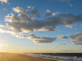
Much of the East-facing Atlantic seacoast of Cape Cod consists of wide, sandy beaches. In 1961, a significant portion of this coastline—already slated for housing subdivisions—was made a part of the Cape Cod National Seashore by President John F. Kennedy, and thus is protected from development. Large portions are open to the public, including the Marconi Site in Wellfleet, a park built around the site of the first two-way transoceanic radio transmission from the United States (by Theodore Roosevelt using Guglielmo Marconi's equipment).
Lighthouses of Cape Cod
"Lighthouses, from ancient times, have fascinated members of the human race. There is something about a lighted beacon that suggests hope and trust and appeals to the better instincts of mankind." - Edward Rowe Snow
Due to its constantly moving and dangerous shoals, since very early in its history Cape Cod's shores have featured beacons which warn ships of the danger. There are numerous working lighthouses on Cape Cod and the Islands, including Highland Light, Nauset Light, Chatham Light, Race Point Light, and Nobska Light, operated by the U.S. Coast Guard, which are frequently photographed symbols of Cape Cod. Others include:
Upper Cape: Wings Neck
Mid Cape: Sandy Neck, South Hyannis, Lewis Bay, Bishop and Clerks, Monomoy, Bass River, Stage Harbor
Outer Cape: Wood End, Long Point, Pamet, Mayo Beach, Billingsgate, Three Sisters, Nauset, Highland
Transportation
Cape Cod is connected to the mainland by a pair of canal-spanning highway bridges from Bourne and Sagamore that were constructed in the 1930s, and a vertical-lift railroad bridge. The limited number of access points to the peninsula can result in large traffic backups during the tourist season.
The entire Cape is roughly bisected lengthwise by U.S. Route 6, locally known as the Mid-Cape Highway and officially as the Grand Army of the Republic Highway.
Commercial air service to Cape Cod operates out of Barnstable Municipal Airport and Provincetown Municipal Airport. Several bus lines service the Cape. There are ferry connections from Boston to Provincetown, as well as from Hyannis to the islands.
Cape Cod has a public transportation network comprising buses operated by three different companies, a rail line, taxis and paratransit services.
Bus
Cape Cod Regional Transit Authority (CCRTA) operates a public bus system called the Breeze, which covers almost the entire Cape. They have three year-round long-distance routes:
- The Sealine, which covers the western half of Cape Cod between Hyannis and Falmouth
- The H20, which runs between Hyannis and Orleans
- The Flex, which covers the Outer Cape, from Harwich to Provincetown. The Flex permits off-route drop-offs and pickups of up to 3/4 miles for an increased fare.
There are also two Barnstable/Hyannis local routes that run year round. In the summer, additional local routes run in Falmouth/Woods Hole (WOOSH), Provincetown, and Yarmouth, as well as a free beach shuttle in Hyannis. CCRTA also operates the B-Bus paratransit service.
Long distance bus service is operated by Plymouth and Brockton Street Railway, with regular service to Boston and Logan Airport, as well as less frequent service to Provincetown. Peter Pan Bus Lines also runs long distance service to Providence T.F. Green Airport and New York City.
Rail
Regular passenger rail service through Cape Cod ended in 1959. In 1978, the tracks east of South Dennis were abandoned and replaced with the very popular bicycle trail, known as the Cape Cod Rail Trail. Another bike trail, the Shining Sea Bikeway, was built over tracks between Woods Hole and Falmouth in 1975; construction to extend this path to North Falmouth over 6.3 miles of inactive rail bed began in April 2008[13]. Active freight service remains in the Upper Cape area in Sandwich in Bourne, largely due to a trash transfer station located at Massachusetts Military Reservation. In 1986, Amtrak ran a seasonal service in the summer from New York City to Hyannis called the Cape Codder. Since its demise in 1996, there have been periodic discussions about reinstating passenger rail service from Boston to reduce car traffic to and from the Cape, with officials in Bourne seeking to extend MBTA's commuter service from Middleboro to Buzzards Bay[14].
Cape Cod Central Railroad operates passenger train service on Cape Cod. The service is primarily tourist oriented and includes a dinner train. The scenic route between Downtown Hyannis and the Cape Cod Canal is about 2½ hours round trip.
Taxi
Taxicabs are plentiful, with several different companies operating out of different parts of the Cape. Fares for a trip between Downtown Hyannis and Barnstable Village can be as high as $20-$25. In Provincetown, the taxi companies charge per person rather than by distance.
Tourism
Although Cape Cod has a year-round population of about 230,000, it experiences a tourist season each summer between Memorial Day and Labor Day, as the New England cold gives way to a brief but comfortable summer. Many businesses are specifically targeted to summer visitors, and close during the 8 to 9 months of the "off season" (although the "on season" has been expanding somewhat in recent years due to Indian Summer, reduced lodging rates, and the number of people visiting the Cape after Labor Day who either have no children (in school at least), and the elderly, reducing the true "off season" to 6 or 7 months). In the late 20th century, tourists and owners of second homes began visiting the Cape more and more in the spring and fall, softening the definition of the high season and expanding it somewhat (see above). Some particularly well-known Cape products and industries include cranberries, shellfish (particularly oysters and clams) and lobstering.
Provincetown, at the tip of Cape Cod, also berths several whale watching fleets who patrol the Stellwagen Bank National Marine Sanctuary. Most fleets guarantee a whale sighting (mostly humpback whale, fin whale, minke whale, sei whale, and critically endengered, the North Atlantic Right Whale), and one is the only federally certified operation qualified to rescue whales. Provincetown has also long been known as an art colony, attracting writers and artists. Many hotels and resorts are friendly to or cater to gay and lesbian tourists and it is known as a gay mecca in the summer.[15]
Cape Cod is a popular destination for beachgoers from all over. With 559.6 miles of coastline, beaches, both public and private, are easily accessible. The Cape has upwards of sixty public beaches, many of which offer parking for non-residents for a daily fee (in summer). The Cape Cod National Seashore has 40 miles of sandy beach and many walking paths.
Cape Cod is also popular for its outdoor activities like beach walking, biking, boating, fishing, go-karts, golfing, kayaking, miniature golf, and unique shopping. There are 27 public, daily-fee golf courses and 15 private courses on Cape Cod.[16] Bed and breakfasts or vacation houses are often used for lodging.
Sports
The Cape has nine amateur baseball franchises playing within Barnstable County in the Cape Cod Baseball League. The Wareham Gatemen also play in the Cape Cod Baseball League in nearby Wareham, Massachusetts in Plymouth County. The league has been in existence since 1885. Teams in the league are the Bourne Braves, Brewster Whitecaps, Chatham Athletics, Cotuit Kettleers, Falmouth Commodores, Harwich Mariners, Hyannis Mets, Orleans Cardinals, Wareham Gatemen and the Yarmouth-Dennis Red Sox. Pro ball scouts frequent the games in the summer, looking for stars of the future.
The Cape also is home to the Cape Cod Frenzy, a team in the American Basketball Association.
Soccer is alive on Cape Cod with the Cape Cod Crusaders playing in the USL Premier Development League (PDL) soccer based in Hyannis. In addition, a summer Cape Cod Adult Soccer League (CCASL) is active in several towns on the Cape.
The end of each summer is marked with the running of the world famous Falmouth road race which is held on the 3rd Saturday in August. It draws ~10,000 runners to the Cape and showcases the finest runners in the world (mainly for the large purse that the race is able to offer).
The race is 7.2 miles long, which is a non standard distance in any acceptable form of measurement. The reason for the unusual distance is that the man who thought the race up (Tommy Leonard) was a bartender who wanted a race along the coast from one bar (The Cap'n Kidd in Woods Hole) to another (The Brothers Four in Falmouth Heights). While the bar in Falmouth heights is no longer there, the race still starts at the front door of the Cap'n Kidd in Woods Hole and now finishes at the beach in Falmouth Heights.
Islands off Cape Cod
Like Cape Cod itself, the islands south of the Cape have evolved from whaling and trading areas to resort destinations, attracting wealthy families, celebrities, and other tourists. The islands include Nantucket and Martha's Vineyard, as well as Forbes family-owned Naushon Island, which was purchased by John Murray Forbes with profits from opium dealing in the China trade during the Opium War. Naushon is one of the Elizabeth Islands, many of which are privately owned. One of the publicly accessible Elizabeths is the southernmost island in the chain, Cuttyhunk, with a year-round population of 52 people. Several prominent families have established compounds or estates on the larger islands, making these islands some of the wealthiest resorts in the Northeast, yet they retain much of the early merchant trading and whaling culture.
References
- ↑ Several islands off Cape Cod proper—Monomoy Island, Monomoscoy Island, Popponesset Island, and Seconsett Island—are also in Barnstable County, being part of municipalities with land on the Cape.
- ↑ "Provincetown Spit, Cape Cod, Massachusetts". NASA Earth Observatory. Retrieved on 2006-05-02.
- ↑ http://www.falmouthchamber.com/documents/FalmouthVillages.pdf?PHPSESSID=6160630e0f83d1300dfa091e432e78c8 Falmouth Chamber of Commerce (Accessed: December 21, 2006). Falmouth: A Pleasing Octet of Villages. Press kit.
- ↑ http://www.town.barnstable.ma.us/InformationSystems/GIS/VILLAGES.PDF Barnstable, Massachusetts GIS Maps (Accessed: December 21, 2006 E911 Map - Town of Barnstable.
- ↑ Leatherman, Stephen. "DrBeach.org - America's Best Beaches 2007". Dr.Beach.Org. Retrieved on 2007-06-11.
- ↑ Oldale, Robert N. "Coastal Erosion on Cape Cod: Some Questions and Answers". WoodsHole.er.usgs.gov. Retrieved on 2007-11-30.
- ↑ [1]
- ↑ [2]
- ↑ [3]
- ↑ [4]
- ↑ Stephanie Vosk (2007-05-25). "Wampanoag tribe wins recognition", Cape Cod Times. Retrieved on 2007-06-05.
- ↑ Reflections in Bullough's Pond, Summer 2000 edition of Conservation Matters, the journal of the Conservation Law Foundation [ http://www.dianamuir.com/default/BPConservation.html]
- ↑ Reckford, Laura. Lawrence-Lynch Will Build Bike Path, Falmouth Enterprise, retrieved 2008-04-04]
- ↑ The Cape and Islands NPR Station - Cape Cod Rail Connection
- ↑ Provincetown- Hotels, Guest Houses, and Inns (2006) Pink Choice, retrieved 6/10/2007Provincetown lodging
- ↑ Cape Cod Chamber of Commerce, retrieved 6/10/2007golf courses
Further reading
- Massey, A.J., C.S. Carlson, and D.R. LeBlanc. (2006). Ground-water levels near the top of the water-table mound, western Cape Cod, Massachusetts, 2002-04 [Scientific Investigations Report 2006-5054]. Reston, VA: U.S. Department of the Interior, U.S. Geological Survey.
- Masterson, J.P. and J.W. Portnoy. (2005). Potential changes in ground-water flow and their effects on the ecology and water resources of the Cape Cod National Seashore, Massachusetts [General Information Product 13]. Reston, VA: U.S. Department of the Interior, U.S. Geological Survey.
- Walter, D.A. and A.T. Whealan. (2005). Simulated water sources and effects of pumping on surface and ground water, Sagamore and Monomoy flow lenses, Cape Cod, Massachusetts [Scientific Investigations Report 2004-5181]. Reston, VA: U.S. Department of the Interior, U.S. Geological Survey.
External links
- Cape Cod Chamber of Commerce
- Cape Cod travel guide from Wikitravel
|