Canton of Solothurn
| Solothurn | |||
|
|||
| Capital | Solothurn | ||
| Population (2007) | 250,240 (Ranked 12th) | ||
| - Density | 318 /km² | ||
| Area | 791 km² (Ranked 16th) | ||
| Highest point | 1445 m - Hasenmatt | ||
| Lowest point | 277 m - Birs at the cantonal border in Dornach | ||
| Joined | 1481 | ||
| Abbreviation | SO | ||
| Languages | German | ||
| Executive | Regierungsrat (5) | ||
| Legislative | Kantonsrat (100) | ||
| Municipalities | 126 municipalities | ||
| Districts | 10 Bezirke | ||
| Website | www.SO.ch | ||
 |
|||
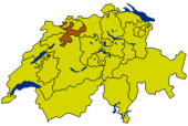
Solothurn (German: Solothurn) is a canton of Switzerland. It is located in the northwest of Switzerland. The capital is Solothurn.
Contents |
Geography
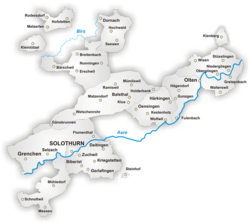
The canton is located in the north west of Switzerland. To the west and south lies the canton of Bern, to the east the one of Aargau. To the north the canton is bound by the canton of Basel-Landschaft. Two of the districts are enclaves and are located along the French border.
The lands are drained by the Aare river and its tributaries. The landscape is mostly flat, but it includes the foothills of the Jura massif. The flat lands are a plain created by the Aare river.
The total area of the canton is 791 km².
History
The lands of the canton consist of territories acquired by the capital. For that reason the shape of the canton is somewhat irregular and includes two enclaves along the French border which form separate districts of the canton.
Between 1798 and 1803 the canton was part of the Helvetic Republic. In 1803 Solothurn was one of the 19 Swiss cantons that were reconstituted by Napoleon (Mediation). Even though the population was strictly Roman Catholic, Solothurn did not join the Catholic separatist movement (Sonderbund) in 1845. Similarly, the federal constitutions of 1848 and 1874 were approved. The current constitution of the canton dates from 1887. In 1895, however, the constitution was thoroughly revised.
Economy
Up to the 19th century agriculture was the main economic activity in the canton. Agriculture is still of importance, but manufacturing and the service industry are now more significant. The industries of the canton are specialized in watches, jewellery, textiles, paper, cement and auto parts. Until recently the manufacturing of shoes was an important economic activity, but global competition meant that the Swiss canton was not competitive enough.
There is a nuclear power plant near Gösgen which started operation in 1979.
Transport
The canton is well connected to other parts of Switzerland, both by rail and road. There is a railway junction at Olten with direct trains to Geneva, Zurich, Basel and the Ticino via Lucerne.
Demographics
The population is mostly German speaking. About 60% of the population are Roman Catholic, with most of the remainder being Protestants. The population is 250,240 (2007) of which 46,898 (or 18.7%) are foreigners[1].
Districts
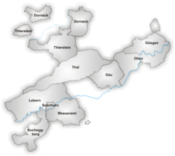
From 2005, Solothurn's ten districts are merged pairwise into five electoral districts, termed Amtei. From 2005, districts only have a statistical meaning.
- Bucheggberg, Amtei Wasseramt-Bucheggberg
- Dorneck, Amtei Dorneck-Thierstein (unofficially Schwarzbubenland)
- Gäu, Amtei Thal-Gäu
- Gösgen, Amtei Olten-Gösgen (unofficially Niederamt)
- Lebern, Amtei Solothurn-Lebern
- Olten, Amtei Olten-Gösgen
- Solothurn, Amtei Solothurn-Lebern
- Thal, Amtei Thal-Gäu
- Thierstein, Amtei Dorneck-Thierstein
- Wasseramt, Amtei Wasseramt-Bucheggberg
Municipalities
The canton has 125 municipalities (Einwohnergemeinden).
|
|
|
External links
- Official site (German)
- Official statistics
 Media related to Canton of Solothurn at Wikimedia Commons
References
- ↑ Bundesamt fur Statistik (Federal Department of Statistics) (2008). "Ständige Wohnbevölkerung nach Staatsangehörigkeit, Geschlecht und Kantonen" (Microsoft Excel). Retrieved on November 5, 2008.