Canadian Rockies
| Canadian Rockies | |
| Range | |
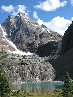 Ringrose Peak, Lake O'Hara, British Columbia
|
|
| Country | North America |
|---|---|
| Provinces | British Columbia, Alberta |
| Part of | Pacific Cordillera |
| Borders on | Canadian |
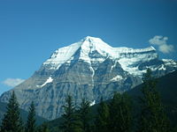
| Highest point | Mount Robson |
| - elevation | 3,954 m (12,972 ft) |
| - coordinates | |
 |
|
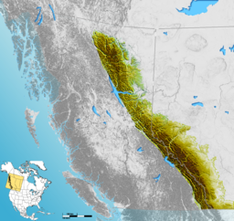
The Canadian Rockies comprise the Canadian segment of the North American Rocky Mountains range. The southern end in Alberta and British Columbia borders Idaho and Montana of the USA. The northern end is at the Liard Plain in British Columbia.
Contrary to popular misconception, the Rockies do not extend into the Yukon or Alaska, or into central British Columbia. North of the Liard River, the Mackenzie Mountains, which are not part of the Rockies, form a portion of the border between the Yukon and the Northwest Territories. The mountain ranges to the west of the Rocky Mountain Trench in southern British Columbia are called the Columbia Mountains and are not considered to be part of the Rockies.
Contents |
Geology
The Canadian Rockies are the easternmost part of the Canadian Cordillera, the collective name for the mountains of Western Canada. They form part of the American Cordillera, an essentially continuous sequence of mountain ranges that runs all the way from Alaska to the very tip of South America. The Cordillera in turn are the eastern part of the Pacific Ring of Fire that runs all the way around the Pacific Ocean.
The Canadian Rockies are bounded on the east by the Canadian Prairies, on the west by the Rocky Mountain Trench , and on the north by the Liard River. The southern boundary is somewhat arbitrary since the mountain trend continues on into the United States, but could be considered to be Marias Pass in Montana, which separates them from the geologically different American Rockies.
The Canadian Rockies are distinct from the American Rockies in that they are older mountains, they were primarily formed by overthrusting whereas the American Rockies were primarily formed by uplifting, and they are almost exclusively sedimentary rock, whereas the American Rockies are cored with granite. Their physical appearance is different because the Canadian Rockies have been very heavily glaciated, resulting in sharply pointed mountains separated by wide, U-shaped valleys gouged by glaciers, whereas the American Rockies are more rounded with river-carved V-shaped valleys between them.
Parks
Five national parks are located within the Canadian Rockies, four of which interlock and make up the Canadian Rocky Mountain Parks World Heritage site. These four parks are Banff, Jasper, Kootenay and Yoho. The national park not included in the World Heritage Site is Waterton, which does not interlock with the others (it lies farther south, along the international boundary). The World Heritage site also includes three British Columbia provincial parks that adjoin the four national parks: Hamber, Mount Assiniboine and Mount Robson. Together, all these national and provincial parks were declared a single UNESCO World Heritage Site in 1984[1] for the unique mountain landscapes found there, comprising peaks, glaciers, lakes, waterfalls, canyons and limestone caves as well as fossils (e.g. the Burgess Shale, once a World Heritage Site in its own right, is now part of the Canadian Rocky Mountain Parks World Heritage Site). Numerous other provincial parks are located in the Canadian Rockies.
Throughout the Rockies, and especially in the national parks, the Alpine Club of Canada maintains a series of alpine huts[2] for use by mountaineers and adventurers.
Highest peaks
| Mountain/Peak | metres | feet | notes |
|---|---|---|---|
| Mount Robson | 3,954 | 12,972 | Highest point in the Canadian Rockies |
| Mount Columbia | 3,747 | 12,293 | Highest point in Alberta |
| North Twin Peak | 3,684 | 12,087 | |
| Mount Clemenceau | 3,658 | 12,001 | |
| Mount Alberta | 3,619 | 11,873 | Most difficult +11,000 climbing objective |
| Mount Assiniboine | 3,618 | 11,871 | Highest point in the Southern Rockies |
| Mount Forbes | 3,612 | 11,850 | |
| South Twin Peak | 3,566 | 11,700 | |
| Mount Temple | 3,543 | 11,624 | Highest point near Lake Louise |
| Mount Bryce | 3,507 | 11,506 | |
| Mount Kitchener | 3,505 | 11,500 | |
| Mount Hungabee | 3,492 | 11,456 | |
| Mount Brazeau | 3,470 | 11,385 | |
| Mount Athabasca | 3,491 | 11,453 | |
| Snow Dome | 3,456 | 11,339 | |
| Mount Andromeda | 3,450 | 11,319 | |
| Mount Joffre | 3,449 | 11,316 | |
| Mount Edith Cavell | 3,363 | 11,033 |
Mount Robson is the highest peak in the Canadian Rockies, but not the highest in British Columbia, since there are higher mountains in the Pacific Coast Ranges and Saint Elias Range. However, Mount Robson is particularly impressive because it stands out on the continental divide towering over Yellowhead Pass, one of the lowest passes in the Canadian Rockies, and is close to the Yellowhead Highway. Its base is only 985 m above sea level, meaning it has a total vertical relief of 2969 m or nearly 10,000 feet. In addition, it rises the 3 km to its summit in a distance of only 4 km from its base at Kinney Lake. Climbing Mount Robson is a challenge suitable for experienced and well-prepared mountaineers, and usually requires a week on the mountain.
Mount Columbia is the second-highest peak in the Canadian Rockies, and is the highest mountain in Alberta. There is a non-technical route to the top involving only kicking steps in the snow, but the approach is across the Columbia Icefield and requires glacier travel and crevasse rescue knowledge. It is normally done in two days, with a night at high camp, but some strong skiers have done from the highway it in a day. On the other hand, many others have been stuck in their tents for days waiting for the weather to clear. From the same high camp as for Mount Columbia, it is possible to ascend a number of other high peaks in the area, including North Twin, South Twin, Kitchener, Stutfield and Snow Dome.
Snow Dome is not an impressive peak by Rockies standards, but it has the distinction of being the hydrological apex of North America. Water flows off Snow Dome into three different watersheds, into the Pacific Ocean, Arctic Ocean, and Atlantic Ocean via Hudson Bay. It is the easiest and most popular ascent on the Columbia Icefield, a gentle ski to the top from Columbia high camp, but glacier travel is required.
For scrambling up peaks of the Canadian Rockies, check out Scrambles in the Canadian Rockies. Note that of the mountains listed above, only Mount Temple has an established scrambling route. All other mountains (including other routes up Mount Temple), require more mountaineering skills and experience. Despite the fact that it is only a moderate scramble, even Mount Temple should not be attempted by novices. According to the Alpine Club of Canada, more people have died on Mount Temple than any other Canadian mountain, including seven youths in an unsupervised American school group in 1955.[3] The upper slopes are usually covered with snow and there is a glacier on top. Scramblers on Mount Temple should carry an ice axe and enough clothing to survive a freezing night on the mountain if a storm hits and prevents them from descending.
For hikers and backpackers, The Canadian Rockies Trail Guide is the original and definitive reference guide book.
Contrary to popular misconception, the Canadian Rockies are not the highest mountain ranges in Canada. Both the Saint Elias Mountains (highest point in Canada Mount Logan at 5959 metres) and the Coast Mountains (highest point Mount Waddington at 4,016 metres) have higher summits.
Mountain ranges
The Canadian Rockies are subdivided into numerous mountain ranges, structured in two main groupings, the Continental Ranges, which has three main subdivisions, the Front Range, Park Ranges and Kootenay Ranges, and the Northern Rockies which comprise two main groupings, the Hart Ranges and the Muskwa Ranges. The division-point of the two main groupings is at Monkman Pass northwest of Mount Robson and to the southwest of Mount Ovington.
- Continental Ranges
- Kootenay Ranges
- Beaverfoot Range, NE of uppermost Columbia River valley
- Stanford Range
- Vermilion Range (British Columbia)
- Front Ranges
- Clark Range on the Continental Divide
- Flathead Range
- Galton Range
- Livingstone Range
- Macdonald Range
- Park Ranges
- Ball Range in Kootenay National Park
- Bare Range in Banff National Park
- Berland Range
- Blackwater Range
- Blairmore Range, east of Blairmore, Alberta
- Blue Range in Banff National Park
- Bosche Range
- Boule Range
- Brazeau Range
- Brisco Range
- Colin Range
- De Smet Range
- Elk Range (BC and Alberta)
- Fairholme Range in the Bow River valley
- Fiddle Range
- Fisher Range
- Lizard Range near Fernie, British Columbia, and in the Elk Valley
- Maligne Range
- Massive Range
- Miette Range
- Misty Range
- Mitchell Range
- Nikanassin Range
- Opal Range
- Ottertail Range
- Kootenay Ranges
-
- Park Ranges (cont.)
- Palliser Range in the SE corner of Banff NP
- Persimmon Range
- President Range in Yoho National Park
- Queen Elizabeth Ranges in Jasper National Park
- Quinn Range
- Rainbow Range
- Ram Range
- The Ramparts Range
- Three Sisters Range in the Elk Valley
- Royal Range
- Sawback Range in SE Banff NP
- Selwyn Range
- Sir Winston Churchill Range in Jasper National Park
- Slate Range in Banff National Park
- Spray Range
- Starlight Range
- Sundance Range
- Ten Peaks Range
- Trident Range
- Van Horne Range
- Van Nostrand Range
- Vermilion Range (Alberta)
- Victoria Cross Ranges in Jasper NP
- Waputik Range
- Wilson Range
- Wisukitsak Range
- Park Ranges (cont.)
- Northern Rockies
- Dezaiko Range
- Hart Ranges
- Misinchinka Ranges (from Pine Pass south to Monkman Pass)
- Murray Range
- Pioneer Range
- Solitude Range
- Misinchinka Ranges (from Pine Pass south to Monkman Pass)
- Muskwa Ranges
- Akie Range
- Battle of Britain Range
- Deserters Range
- Gataga Ranges
- Rabbit Plateau
- Sentinel Range
- Stone Range
- Terminal Range
- Tochieka Range
- Tower of London Range
- Truncate Range
The Rockies and The Canadian Pacific Railway
The Canadian Pacific Railway was founded to provide a link from the province of British Columbia to the eastern provinces. The main difficulty in providing such a link were the Rockies themselves: treacherous mountain passes, fast rivers and sheer drops made for a difficult railway construction process. The following articles describe in detail the political and technical feats involved:
- Canadian Pacific Survey
- Big Hill
- Field Hill
- Kicking Horse Pass
- Spiral Tunnels
See also
- Arctic Cordillera - an example of another major mountain system in North America east of the Canadian Rockies.
References
- ↑ UNESCO World Heritage listing
- ↑ Alpine Club of Canada - alpine huts
- ↑ Alpine Club of Canada - Alpine Accidents in Canada
|
|||||||||||||||||||||||||||||||
|
||||||||||||||||||||||||||||||||||||||