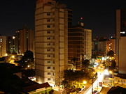
Campinas
| Campinas | |||
| — Municipality — | |||
| The Municipality of Campinas | |||
 |
|||
|
|||
| Nickname(s): Cidade das Andorinhas, Brazilian Silicon Valley, Princesa d'Oeste | |||
 |
|||
| Country | |||
|---|---|---|---|
| Region | Southeast | ||
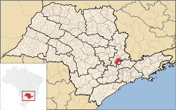
| State | São Paulo | ||
| Founded | July 14, 1774 | ||
| Government | |||
| - Mayor | Hélio de Oliveira Santos (PDT) | ||
| Area | |||
| - Municipality | 797.6 km² (308 sq mi) | ||
| - Metro | 3,645 km² (1,407.3 sq mi) | ||
| Elevation | 685 m (2,247 ft) | ||
| Population (2006) | |||
| - Municipality | 1,059,420 | ||
| - Density | 1,331/km² (3,447.3/sq mi) | ||
| - Metro | 3,2 million people | ||
| Time zone | UTC-3 (UTC-3) | ||
| - Summer (DST) | UTC-2 (UTC-2) | ||
| Postal Code | 13000-000 | ||
| Area code(s) | 19 | ||
| HDI (2000) | 0.852 – high | ||
| Website: Campinas, São Paulo | |||


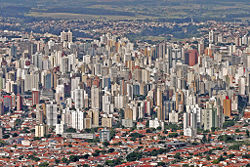
Campinas (pronounced [kɐ̃ːˈpinɐs]) is a city and county (município) located in the state of São Paulo, Brazil.
The county area is 797,6 km². Population is approximately 1,059,420 (2004 est.), with over 98% in the urban region. Its metropolitan area, defined in 2000, has some 19 cities and a population of 3,2 million people. Campinas is also the administrative center of the meso-region of the same name, with 3,641,766 inhabitants (2005 est.) and 49 cities. It is the third largest city in the state, after São Paulo (10,927,985 inhab. - 2006 est.) and Guarulhos (1,283,253 inhab. - 2006 est.).
The Viracopos International Airport connects Campinas with many Brazilian cities and also operates some international flights.
The city is home to the State University of Campinas.
Geography
Ecology
Campinas has a relevant ecological interest area (Portuguese: Área de Relevante Interesse Ecológico) — Santa Genebra forest, with 2.51 km², created in 1985 and regulated by IBAMA, Campinas City Hall and José Pedro de Oliveira Foundation.
Among the public parks, there are the "Bosque Municipal", the "Lagoa do Taquaral Park", the "Ecological Park of Campinas" and the "Lagoa da UNICAMP" Park. These parks feature jogging and bicycle paths.
Climate
| for Campinas | |||||||||||||||||||||||||||||||||||||||||||||||
|---|---|---|---|---|---|---|---|---|---|---|---|---|---|---|---|---|---|---|---|---|---|---|---|---|---|---|---|---|---|---|---|---|---|---|---|---|---|---|---|---|---|---|---|---|---|---|---|
| J | F | M | A | M | J | J | A | S | O | N | D | ||||||||||||||||||||||||||||||||||||
|
310
29
19
|
202
28
19
|
152
27
18
|
63
26
17
|
59
24
14
|
29
23
13
|
13
22
12
|
18
24
14
|
54
26
16
|
109
27
17
|
163
28
18
|
237
29
19
|
||||||||||||||||||||||||||||||||||||
| temperatures in °C precipitation totals in mm source: MSN Weather |
|||||||||||||||||||||||||||||||||||||||||||||||
|
Imperial conversion
|
|||||||||||||||||||||||||||||||||||||||||||||||
Campinas is located on the São Paulo plateau, in the transition area to the Serra da Mantiqueira mountain range. It has an excellent climate throughout the year, characterized by mostly sunny and hot days (more than 200 days in the year), a mild temperature range (average yearly temperature of 22.4 degrees Celsius, ranging from an average minimum of 7.2 degrees to a maximum of 35.9 degrees) and a constant regime of cool winds. Due to this, Campinas has little air pollution and smog and the local airports almost never close due to bad weather. Thanks to a regular rain regimen, the region's vegetation is evergreen, and some crops, such as sugarcane have three harvests per year.
The wet season is from mid-October to mid-June, with heavier rains particularly in January and February, and the dry season is from mid-May to mid-September. Average rainfall is 24.3 mm in August and 267.8 mm in January. Average humidity ranges from 37% (August) to 56% (January).
In the region around Campinas near the state of Minas Gerais there are a number of cities enjoying an even milder mountain climate, such as Atibaia, Águas de Lindóia, Itapira, Itatiba, Joanópolis, Serra Negra, Socorro, where several water spas are located.
History


The city was founded on July 14, 1774, by Barreto Leme. It was initially a simple outpost on the way to Minas Gerais and Goiás serving the "Bandeirantes" who were in search of precious minerals and Indian slaves. In the first half of the 19th century, Campinas became a growing population center, with many coffee and sugarcane farms.
The construction of a railway linking the city of São Paulo to Santos' seaport, in 1867, was very important for its growth. In the second half of the 19th century, with the abolition of slavery, farming and industrialization attracted many foreign immigrants to replace the lost manpower, mainly from Italy.
Coffee became an important export and the city became wealthy. In consequence, a large service sector was established to serve the growing population, and in the first decades of the 20th century, Campinas could already boast of having an opera house, theaters, banks, movie theaters, radio stations, a philharmonic band, two newspapers (Correio Popular and Diário do Povo), a good public education system (with the Escola Normal de Campinas and the Colégio Culto à Ciência), and hospitals, such as the Santa Casa de Misericórdia (a charity for poor people) and the Casa de Saúde de Campinas (for the Italian community), and the most important Brazilian research center in agricultural sciences, the Instituto Agronômico de Campinas, which was founded by Emperor Pedro II. Finally, the construction of the first Brazilian highway in 1938, between Campinas and São Paulo, the Anhanguera Highway, was a turning point in the integration of Campinas into the rest of the state.
Campinas was the birthplace of opera composer Carlos Gomes (1836 — 1896) and of the President of the Republic Campos Salles (1841 — 1913). It was home for 49 years for Hércules Florence, reputed as one of the early inventors of photography, photocopying and the mimeograph.
Title and symbols

Campinas means grass fields in Portuguese and refers to its characteristic landscape, which originally comprised large stretches of dense subtropical forests (mato grosso or thick woods in Portuguese), mainly along the many rivers, interspersed with gently rolling hills covered by low-lying vegetation.
Campinas is also known as "Cidade das Andorinhas" (City of Swallows), because it was a favorite spot for these migratory birds, which flocked annually in enormous numbers to downtown Campinas. However, they almost disappeared around the 1950s, probably because the church and plaza where they used to roost were torn down. Campinas' official crest and flag has a picture of the mythical bird, the phoenix, because it was practically reborn after a devastating epidemic of yellow fever in the 1800s, which killed more than 25% of the city's inhabitants.
An inhabitant of Campinas is called a campineiro.
Metropolitan Region of Campinas
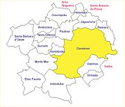


As of 2000, Campinas became an official metropolitan region (RMC — Região Metropolitana de Campinas), with 19 municipalities, with a total of 2.3 million inhabitants and a total land area of 3,348 km² (data of 2000), adjacent to the São Paulo metropolitan region (RMSP).
- Americana
- Artur Nogueira
- Cosmópolis
- Engenheiro Coelho
- Holambra
- Hortolândia
- Indaiatuba
- Itatiba
- Jaguariúna
- Monte Mor
- Nova Odessa
- Paulínia
- Pedreira
- Santa Bárbara d'Oeste
- Santo Antônio de Posse
- Sumaré
- Valinhos
- Vinhedo
The Campinas municipality is also the administrative center of the micro- and meso-regions of the same name. The micro-region includes the RMC (Metropolitan Region of Campinas) and the municipality of Elias Fausto; the meso-region also includes the following municipalities: Aguaí, Amparo, Águas da Prata, Águas de Lindóia, Caconde, Casa Branca, Divinolândia, Espírito Santo do Pinhal, Estiva Gerbi, Itapira, Itobi, Lindóia, Mococa, Mogi Guaçu, Moji-Mirim, Monte Alegre do Sul, Pedra Bela, Pinhalzinho, Pirassununga, Porto Ferreira, Santa Cruz das Palmeiras, Santo Antônio do Jardim, São João da Boa Vista, São José do Rio Pardo, São Sebastião da Grama, Serra Negra, Socorro, Tambaú, Tapiratiba, Vargem Grande do Sul and Vinhedo.
Other cities which are geographically, historically or economically tied to the meso-region of Campinas could be mentioned: Araras, Atibaia, Bragança Paulista, Capivari, Conchal, Iracemápolis, Itu, Itupeva, Jarinu, Jundiai, Limeira, Louveira, Mombuca, Morungaba, Piracicaba, Rafard, Rio das Pedras, Salto and Tuiuti.
Economy
- See also: List of companies in Campinas


Campinas' main economic activities are agriculture (mainly coffee, sugarcane, and cotton), industry (textiles, motorcycles, cars, machinery, agricultural equipment, food and beverages, chemical and petrochemical, pharmaceuticals, paper and cellulose, telecommunications, computers and electronics, etc.), commerce and services.
The Campinas Metropolitan Region is home to many national and international high-tech industries, including IBM, Motorola, Freescale, Lucent, Nortel, Compaq, Celestica, Samsung, Alcatel, Bosch, 3M, Texas Instruments.[1]
The automotive industry is also heavily represented: General Motors, Mercedes-Benz, Honda, Magneti Marelli, Eaton Corporation, Tenneco, Toyota and many others are present.[2] It also has a sizable pharmaceutical industry sector, with companies like Medley Farma, EMS Farma, Altana, Merck Sharp and Dohme, Cristália, Valeo, etc.[3]
In addition the region is home to many research centers and universities, such as LNLS, CPqD, CenPRA, Embrapa, Unicamp, Facamp and Puccamp. According to the Times Higher Education 2007 World University Rankings, the University of Campinas (Unicamp) is the 177th best university in the world, and the 2nd best in Latin America (after the University of São Paulo in 176th place).
Campinas also boasts the largest number of high-tech business incubators and industrial parks (a total of eight), such as the CIATEC I and II, Softex, TechnoPark, InCamp, Polis, TechTown, Industrial Park of Campinas and others.[4]
The presence of one of the largest oil refineries in Latin America (350,824 barrels of crude per day), operated by Petrobras in the neighboring county of Paulínia, has attracted many petrochemical companies to the Campinas area, including DuPont, Rhone-Poulenc, and Royal Dutch Shell.[5]
The Brazilian Pró-Álcool Program was developed in Campinas: a whole industry based on the use of ethanol as a combustible for motor vehicles, going from a new sucrose-rich sugarcane, to alcohol refineries, a huge distribution system, and, most recently, an internal combustion engine capable of using either gasoline or ethanol.[6]
Other examples of Campinas-bred technologies are fiber optics, lasers for telecommunications and medical applications, integrated circuits design and fabrication, satellite environmental monitoring of natural resources, software for agriculture, digital telephone switches, deep-water oil exploration platforms and technologies, biomedical equipment, medical software, genetic engineering and recombinant DNA technologies for food production and pharmaceutics, and food engineering.[7]
Socio-economic conditions


Despite Campinas' position of wealth and social and economic opportunity vis-a-vis the rest of the country, the average per capita income of little more than US$ 2,700 per year clearly indicates that there are problems. If re-evaluated in terms of PPP (Purchasing Power Parity), Campinas' average income looks better (roughly 9,000 USD per year). In fact, Campinas is emblematic of the wealth distribution inequality that is so common in the country (Brazil is the 9th largest economy in the world, but ranks only 32nd in wealth generation per capita, and 117th in average Gini coefficient). Campinas has a Gini coefficient of 58%, which is almost the same as that of Brazil (59.3), a level similar to countries such as Zimbabwe and Paraguay. Such a level means that the top 10% richest make almost 70 times more than the 10% poorest.
This level of poverty contrasts with the high Human Development Index of Campinas, which is about the same level as Chile, Hungary, Poland, Lithuania and Slovakia. The explanation for this apparent contradiction is that side by side, even in the same city section, one can find walled condominiums with a yearly average per capita income of US$ 60,000 to US$ 100,000 and spreading "favelas" (slum cities) with incomes of less than US$ 800 p.a. The classes A and B help move the local economy, and provide a strong tax base for the municipality.
Until the late 1970s, Campinas was proud to have no favelas, but the increasing industrialization and wealth attracted hordes of destitute agrarian workers and urban dwellers with few job qualifications from all parts of the country. Land invasions were frequent and the municipal powers were unable or unwilling to suppress them, allowing illegal occupation of land in key sectors of the city (in Brazil, state and counties are forbidden by the Federal Constitution to restrict or even measure the free movement of citizens).
Transportation


Campinas is a major transportation and telecommunications hub for the State of São Paulo, as it is located on the major highways that connect the capital to the Northwest and Northern parts of the State. The city is served by the a Campinas Beltway (Anel Viário) and the following main highways:
- Rodovia Anhangüera
- Rodovia dos Bandeirantes
- Rodovia Santos Dumont
- Rodovia Dom Pedro I
- Rodovia Adhemar de Barros
- Rodovia General Milton Tavares de Souza
- Rodovia Jornalista Francisco Aguirre Proença
All these highways are built according to the highest international standards (see highway system of São Paulo).[8] The Anel Viário José Magalhães Teixeira (SP-038) around the city currently interconnects the Anhangüera and Dom Pedro I highways.
Campinas has long been a major railway hub, too, although passenger train lines no longer operate there. The city built a light rail line in the early-1990s, but due to low ridership the entire project was abandoned.
International Airport

Viracopos International Airport is located 14 kilometres (8.7 mi) from downtown Campinas and 99 kilometres (62 mi) from the city of São Paulo, Viracopos International Airport can be reached by three highways: Santos Dumont, Bandeirantes and Anhangüera. The city of Campinas is one of Brazil's leaders in technology. Besides excellent highway connections, it is the location of major universities and many high-tech companies. Because of this, the airport today is one of Infraero's highest priorities to receive investments.
The old "landing field" as it was called has become one of the main connection points in Latin America. The air cargo import/export terminal has an area of over 81 thousand square meters. The airport began to awaken in the international air cargo segment in the 1990s and today this is its leading activity. Since 1995, Infraero has been investing to implement the first phase of the airport's master plan, making major improvements to the cargo and passenger terminals. The second phase of the passenger terminal expansion project will be ready in early 2005. The first phase was completed in the first half of 2004, when the airport received new departure and arrival lounges, public areas and commercial concessions.
Communications

Campinas is a major telecommunications hub in the state and in the country. It has the largest per capita number of fixed and mobile telephone lines in the São Paulo state and one of the largest in the country. The city is also a major hub for cable, fiber optic, microwave and satellite communication network. COMSAT operates near Campinas one of the largest satellite ground stations in Latin America, and the National Research and Education Network (Rede Nacional de Pesquisa e Educação) has a high-capacity point of presence (POP) in the city.
Media
Three daily newspapers are published in Campinas, all owned by media company Rede Anhangüera de Comunicação: Correio Popular, Diário do Povo and Notícia Já (a tabloid). Several other local newspapers with weekly or monthly circulation are also published. Several magazines are also published in Campinas, the largest one being Metrópole, which circulates on Sundays as a supplement to Correio Popular.
The city has also a large number of radio stations as well as several local TV stations, including TV Universidades and Fenix TV (both not-for-profit, distributed by Net Campinas, the local cable distributor)
Education


Portuguese is the official national language, and thus the primary language taught in schools. But English and Spanish are part of the official high school curriculum.
Universities and colleges
- Unicamp (Universidade Estadual de Campinas);
- Puccamp (Pontifícia Universidade Católica de Campinas);
- UNIP (Universidade Paulista);
- FACAMP (Faculdades de Campinas);
- METROCAMP (Faculdade Integrada Metropolitana de Campinas);
- IPEP (Faculdades Integradas IPEP);
- UNISAL (Centro Universitário Salesiano);
- USF (Universidade São Francisco);
- ESAMC (Escola Superior de Administração, Marketing e Comunicação);
- Universidade Mackenzie;
- FAC (Faculdades Comunitárias de Campinas);
- Faculdades Fleming;
- Faculdade de Odontologia São Leopoldo Mandic.
Technical schools
- ETE Bento Quirino (Escola Técnica Estadual Bento Quirino)
- ETECAP (Escola Técnica Estadual Conselheiro Antonio Prado)
- COTUCA (Colégio Técnico da Universidade de Campinas)
Culture

The city has always been a cultural center in the State of São Paulo. This has increased greatly with the proliferation of universities. Campinas has three theater houses, a symphony orchestra,(considered one of the three best of the country),now under Principal Conductor Parcival Módolo and Karl Martin, classical music ensembles, choral groups, 43 movie theaters, dozens of libraries (including a municipal library), art galleries, museums, etc.
Sports
Campinas is the home town for two of the oldest and most significant soccer teams of Brazil, the Associação Atlética Ponte Preta and Guarani Futebol Clube (the only Brazilian countryside team to have won the national championship, in 1978). They own two stadiums, the Estádio Brinco de Ouro and the Estádio Moisés Lucarelli, other team is the Campinas Futebol Clube.
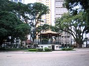
Tourism and recreation


The city does not have many tourist spots, since it is not located at the beach or the mountains, and has no remarkable old monument or construction. However it has some nice places to visit such as:
- the Bosque dos Jequitibás, an urban preserved wooded area reminiscent of the original rain forest that covered the region in the past: it has a small zoo with local fauna and a natural history museum
- the Cathedral, which was built in the 19th century; its interior is entirely made of jacaranda wood sculptures and works;
- the Central Market, with typical stall stands full of fresh product of the region
- the old Central Railway Station, now converted to a cultural center;
- Centro de Convivência, a cultural complex of theater, an open arena for concerts and spectacles, and a plaza where Campinas Symphony Orchestra often plays to the public;
- the Castelo (Castle) Water Tower, which provides a beautiful view over the downtown;
- the Historical Railway Society of Campinas, which maintains the Anhumas station, a set of steam locomotives and full carriages and which promotes regular trips along a picturesque region dotted with old coffee farms;
- the Lagoa do Taquaral Park, a much-beloved urban lagoon and adjacent wooded park, includes: a planetarium, a science museum, an indoor sports stadium and swimming pool, kart racing and model airplane areas, an open concert auditorium, a floating caravel replica, a small railway train ride, pedal boats, plus facilities for several types of sports, including a long track for running and walking;
Campinas' readers of the Correio Popular Newspaper and the Cosmo Website have voted in July 2007 for the "Seven Wonders of Campinas."[9]
The mountain region around Campinas has better travel and stay opportunities, such as in the spa cities of Serra Negra and Águas de Lindóia; and in Holambra, a rural region which was populated by immigrants from the Netherlands, with an annual flower festival and typical buildings and restaurants.
Demographics
- Total population: 1,056,644 (IBGE in the second estimate of July 1, 2008)
- Population density (inhabitants / km ²): 1328.0 (IBGE / 2008)
- Infant mortality up to 1 year (per thousand): 14.05
- Expectation of life (years): 72.22
- Fertility rate (children per woman): 1.78
- Literacy rate: 95.01%
- Human Development Index (HDI-M): 0.852
- HDI-M Income: 0.845
- HDI-M Longevity: 0.787
- HDI-M Education: 0.925
(Source: DATA)
Ethnicity
Source: 2000 census:
| Color / Race | % |
|---|---|
| White | 74.0% |
| Black | 5.6% |
| Pardo | 18.4% |
| Yellow | 0.9% |
| Indigenous | 0.2% |
Administration
The current mayor is Hélio de Oliveira Santos, a physician, former professor of pediatric surgery at the UNICAMP Medical School and federal congressman, who was elected by a coalition of several political parties, led by the Partido Democrático Trabalhista. His term runs from Jan. 1, 2005 to Dec. 31, 2008. The municipality is subdivided into one main district and four subdistricts, Joaquim Egídio, Sousas, Barão Geraldo and Nova Aparecida. There are also 14 regional administrations.
The Secretariat of International Cooperation of Campinas

The Secretariat of International Cooperation (SMCI) was created in April 28, 1994. It is one of the 18 Secretariats of the City Hall of Campinas and it is currently located in that building.[10]
Its mains goals are:
- the attraction and facilititaion for the arrival of new investments to the city;
- the expansion of the companies activities that are already established in the city;
- the perpetuation of the relations between the city, its international community and partners, such as the Sister-Cities.
The Secretariat also acts as supporter to other secretariats in the City Hall, often through: the identification of national and foreign potentials investors; keeping systematic contacts with executives in Brazil and abroad, Embassies, Chambers of Commerces and relevant International Organizations; presenting Campinas to the cities and interested investors.
Notable mayors

- Orozimbo Maia - 1904, 1908-1910, 1926-1930
- Ruy Hellmeister Novais - 1956-1959, 1964-1969
- Orestes Quércia - 1969-1972
- José Roberto Magalhães Teixeira - 1983-1988, 1993-1996 (died of cancer while in office)
- Francisco Amaral - 1977-1982, 1997-2001
- Antonio da Costa Santos (Toninho) - 2001 (murdered while in office)
- Izalene Tiene - 2001-2005
- Hélio de Oliveira Santos (Dr.Hélio) - 2005-present
Notable people
- Campos Sales - politician, fourth president of Brazil
- Carlos Gomes - opera composer
- Durval de Lima Junior - musician and actor
- Maitê Proença - actress
- Nelsinho Baptista - soccer player
- Olavo de Carvalho - philosopher and writer
- Sandy Leah Lima - singer and actress
- Lovefoxxx - singer of the New Wave band Cansei de Ser Sexy
City twinning
Campinas is officially twinned (sister city) with the following cities:[11]
|
Campinas and the following cities have agreed upon sisterhood Protocol of Intentions:
 Turin, Italy;
 Fushun, China;
- Jingan, China;
- Bissau, Guinea-Bissau;
 Santa Cruz de la Sierra, Bolívia;
References
- ↑ IT industries in Campinas
- ↑ Automotive industry in Campinas
- ↑ Pharmaceutical industry sector in Campinas
- ↑ Business incubators and industrial parks in Campinas
- ↑ Petroleum in Campinas
- ↑ Ethanol in Campinas
- ↑ Biotechnology in Campinas
- ↑ Highways in Campinas
- ↑ [1]
- ↑ [2]
- ↑ "Malito torna-se cidade-irmã de Campinas". www.campinas.sp.gov.br.
External links
- Official home page (in Portuguese).
- Secretariat of International Cooperation official home page
- Campinas Yellow Pages (in Portuguese).
- Photo album.
- The Seven Wonders of Campinas (in Portuguese)
- Campinas Business Directory (in Portuguese).
- Campinas' Region (In Portuguese)
- Trade Point Campinas (export/import info).
- Campinas American Chamber of Commerce
- Current local time.
- Current weather.
- Hotel information.
- Correio Popular newspaper site.
- Diário do Povo newspaper site.
- Campinas Videoconference Center
- Campinas Convention and Visitors Bureau
- Campinas' Wired magazine story, July 2000.
- FallingRain Map - elevation = 919m (Red dots are railways)
|
|||||||||||||||||||||||||||||||||||||||||||||
|
|||||