Campeche
- Campeche is the name of both a state in Mexico and its capital city. This article is about the state. For the city, see: Campeche, Campeche; for the Puerto Rican artist, see José Campeche.
| State of Campeche | |||
|
|||
 |
|||
 |
|||
| Country | |||
|---|---|---|---|
| Capital | Campeche | ||
| Municipalities | 11 | ||
| Largest City | San Francisco de Campeche | ||
| Government | |||
| - Governor | Jorge Carlos Hurtado Valdez (PRI) | ||
| - Federal Deputies | PRI:2 | ||
| - Federal Senators | PRI:2 PAN:1 |
||
| Area Ranked 18th |
|||
| - Total | 50,812 km² (19,618.6 sq mi) | ||
| Population (2005) | |||
| - Total | 754,730 (Ranked 30th) | ||
| Time zone | CST (UTC-6) | ||
| - Summer (DST) | CDT (UTC-5) | ||
| HDI (2004) | 0.8189 - high Ranked 9th |
||
| ISO 3166-2 | MX-CAM | ||
| Postal abbr. | Camps. | ||
| Website: http://www.campeche.gob.mx | |||
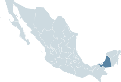
The State of Campeche is a state in the south-east region of the Mexican Republic. It is bordered by the Mexican states of Yucatán to the north east, Quintana Roo to the east, and Tabasco to the south west. To the south it is bordered by the Petén department of Guatemala and to the west by the Gulf of Mexico. Since 1996, Campeche also shares a short border with the nation of Belize to the east, although the anexation of this area by Campeche remains disputed by Quintana Roo [1].
The area of Campeche is 56,798 square kilometers (21,929.8 sq mi), and the population was only 754,730 inhabitants at the 2005 census. This makes Campeche one of the states with the lowest population densities in Mexico (fifth behind Baja California Sur, Durango, Sonora, and Chihuahua).
The capital city of the state is the city of San Francisco de Campeche, which was declared a World Heritage Site by UNESCO.
In addition to the city of Campeche, the state of Campeche includes the cities of Champotón, Ciudad del Carmen, and Escárcega, the towns of Bolonchén, Calkiní, Dzitbalché, Hecelchakán, Hopelchén, Lerma, Tenabo, and Sabancuy, and many ruins of the Maya civilization such as Becán, Calakmul, Silvituc, Dzibilnocac, Edzná, Hocchob, Holactún, Río Bec, Uxul, Xicalango, Xpuhil, and Xtampak.
Campeche derives from the name of the Mayan city of Kan pech, which became today's San Francisco de Campeche.
Contents |
History
Before the Spanish Conquest, the territory that now is the State of Campeche was occupied by the Maya. The most important sites of the Classic Maya Period are Calakmul, Rio Bec, Edzná, Hormiguero and Becán. Another important site is the island of Jaina, just off the coast in the Gulf of Mexico.
Campeche was discovered by the Spaniards on March 22, 1517, during an exploratory expedition led by Francisco Fernandez de Córdoba. Among the crew were Bernal Díaz del Castillo and Antón de Alaminos.
The name of Campeche comes from the Mayan word "Ah Kim Pech", which means "The Place of Boa Serpent".
The State of Campeche was long a part of Yucatán and shared its history through the mid 19th century. Campeche broke away from Yucatán and became a separate state of the United Mexican States (Estados Unidos Mexicanos) on August 7, 1857.
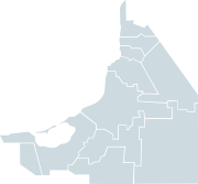
Municipalities
The State of Campeche is divided into 11 municipalities (Spanish: municipios), each headed by a municipal president (mayor).
Demographics
- Inhabitants: 754,730
- Age Average: 24 years.
- Annual Population Growth: 1.46%
- Population at the Capital: 216,900.
- Population that speaks a native tongue: 89,000.
- Population that does not speak Spanish: 3,140
Data from the II Conteo de Población y Vivienda 2000, INEGI.
References
External links
- Yucatan Today - The leading tourist guide to Meria and YUcatan - article about Campeche
- (Spanish) Campeche State Government
- (Spanish) Towns, cities, and postal codes in Campeche
|
||||||||||