Bryce Canyon National Park
| Bryce Canyon National Park | |
|---|---|
| IUCN Category II (National Park) | |
 |
|
| Location | Garfield County and Kane County, Utah, USA |
| Nearest city | Tropic, Panguitch |
| Coordinates | |
| Area | 35,835 acres (145 km²) |
| Established | September 15, 1928 |
| Visitors | 1,012,563 (in 2007) |
| Governing body | National Park Service |
Bryce Canyon National Park (pronounced /ˈbraɪs/) is a national park located in southwestern Utah in the United States. Contained within the park is Bryce Canyon. Despite its name, this is not actually a canyon, but rather a giant natural amphitheater created by erosion along the eastern side of the Paunsaugunt Plateau. Bryce is distinctive due to its geological structures, called hoodoos, formed from wind, water, and ice erosion of the river and lakebed sedimentary rocks. The red, orange and white colors of the rocks provide spectacular views to visitors. Bryce is at a much higher elevation than nearby Zion National Park and the Grand Canyon. The rim at Bryce varies from 8,000 to 9,000 feet (2,400 to 2,700 m), whereas the south rim of the Grand Canyon sits at 7,000 feet (2,100 m) above sea level.
The canyon area was settled by Mormon pioneers in the 1850s and was named after Ebenezer Bryce, who homesteaded in the area in 1874.[1] The area around Bryce Canyon became a U.S. National Monument in 1923 and was designated as a national park the next year. The park covers 56 square miles (145 km²). The park receives relatively few visitors compared to Zion Canyon and the Grand Canyon, largely due to its remote location. The town of Kanab, Utah, is situated at a central point between these three parks.
Contents |
Geography
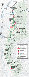
Bryce Canyon National Park is located in southern Utah about 50 miles (80 km) northeast and 1,000 feet (300 m) higher than Zion National Park.[2] The weather in Bryce Canyon is therefore cooler, and the park receives more precipitation—a total of 15 inches (38 cm) to 18 inches (46 cm) per year.[3][4] Yearly temperatures vary from an average minimum of 9 °F (−13 °C) in January to an average maximum of 83 °F (28 °C) in July but extreme temperatures can range from −30 °F (−34.4 °C) to 97 °F (36 °C).[4] A nearby example, very similar to Bryce Canyon but at a higher elevation, is in Cedar Breaks National Monument, which is 25 miles (40 km) to the west on the Markagunt Plateau.[2]
The national park lies within the Colorado Plateau geographic province of North America and straddles the southeastern edge of the Paunsagunt Plateau west of the Paunsagunt Fault (Paunsagunt is Paiute for "home of the beaver").[5] Park visitors arrive from the plateau part of the park and look over the plateau's edge toward a valley containing the fault and the Paria River just beyond it (Paria is Paiute for "muddy or elk water"). The edge of the Kaiparowits Plateau bounds the opposite side of the valley.
Bryce Canyon was not formed from erosion initiated from a central stream, meaning it technically is not a canyon. Instead headward erosion has excavated large amphitheater-shaped features in the Cenozoic-aged rocks of the Paunsagunt Plateau.[5] This erosion exposed delicate and colorful pinnacles called hoodoos that are up to 200 feet (61 m) high. A series of amphitheaters extends more than 20 miles (32 km) north-to-south within the park.[5] The largest is Bryce Amphitheater, which is 12 miles (19 km) long, 3 miles (4.8 km) wide and 800 feet (240 m) deep.[5]
Rainbow Point, the highest part of the park at 9,105 feet (2,775 m),[6] is at the end of the 18-mile (29 km) scenic drive.[5] From there, Aquarius Plateau, Bryce Amphitheater, the Henry Mountains, the Vermilion Cliffs and the White Cliffs can be seen. Yellow Creek, where it exits the park in the north-east section, is the lowest part of the park at 6,620 feet (2,020 m).[4]
hi
Geology
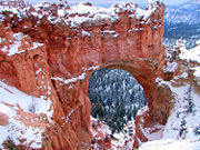
The Bryce Canyon area shows a record of deposition that spans from the last part of the Cretaceous period and the first half of the Cenozoic era. The ancient depositional environment of the region around what is now the park varied:
- The Dakota Sandstone and the Tropic Shale were deposited in the warm, shallow waters of the advancing and retreating Cretaceous Seaway (outcrops of these rocks are found just outside park borders).[7]
- The colorful Claron Formation that the park's delicate hoodoos are carved from was laid down as sediments in a system of cool streams and lakes that existed from 63 to about 40 million years ago (from the Paleocene to the Eocene epochs). Different sediment types were laid down as the lakes deepened and became shallow and as the shoreline and river deltas migrated.
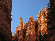
Several other formations were also created but were mostly eroded away following two major periods of uplift:
- The Laramide orogeny affected the entire western part of what would become North America starting about 70 million to 50 million years ago.[8] This event helped to build the ancestral Rocky Mountains and in the process closed the Cretaceous Seaway. The Straight Cliffs, Wahweap, and Kaiparowits formations were victims of this uplift.
- The Colorado Plateaus were uplifted 16 million years ago and were segmented into different plateaus — each separated from its neighbors by faults and each having its own uplift rate.[6] The Boat Mesa Conglomerate and the Sevier River Formation were removed following this uplift.
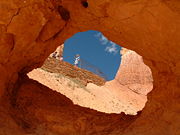
Vertical joints were created by this uplift, which were eventually (and still are) preferentially eroded. The easily eroded Pink Cliffs of the Claron Formation responded by forming freestanding pinnacles in badlands called hoodoos, while the more resistant White Cliffs formed monoliths.[5] The brown, pink and red colors are from hematite (iron oxide; Fe2O3); the yellows from limonite (Fe2O3•nH2); and the purples are from manganese oxide (MnO2).[9] Also created were arches, natural bridges, walls, and windows. Hoodoos are composed of soft sedimentary rock and are topped by a piece of harder, less easily eroded stone that protects the column from the elements. Bryce Canyon has one of the highest concentrations of hoodoos of any place on Earth.
The formations exposed in the area of the park are part of the Grand Staircase. The oldest members of this supersequence of rock units are exposed in the Grand Canyon, the intermediate ones in Zion National Park, and its youngest parts are laid bare in Bryce Canyon area. A small amount of overlap occurs in and around each park.
Biology
More than 400 native plant species live in the park. There are three life zones in the park based on elevation:[4]
- The lowest areas of the park are dominated by dwarf forests of pinyon pine and juniper with manzanita, serviceberry, and antelope bitterbrush in between. Aspen cottonwoods, Water Birch, and willow grow along streams.
- Ponderosa Pine forests cover the mid-elevations with Blue Spruce and Douglas-fir in water-rich areas and manzanita and bitterbrush as underbrush.
- Douglas-fir and White Fir, along with Aspen and Engelmann Spruce, make up the forests on the Paunsaugunt Plateau. The harshest areas have Limber Pine and ancient Great Basin Bristlecone Pine—some more than 1,600 years old—holding on.[10]
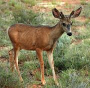
The forests and meadows of Bryce Canyon provide the habitat to support diverse animal life, from birds and small mammals to foxes and occasional bobcats, mountain lions, and black bears.[10] Mule deer are the most common large mammals in the park.[10] Elk and pronghorn antelope, which have been reintroduced nearby, sometimes venture into the park.
Bryce Canyon National Park forms part of the habitat of three wildlife species that are listed under the Endangered Species Act: Utah Prairie Dog, California condor, and the Southwestern Willow Flycatcher.[11] The Utah prairie dog is a threatened species that was reintroduced to the park for conservation, and the largest protected population is found within the park's boundaries.[12]
About 170 species of birds visit the park each year, including swifts and swallows.[4] Most species migrate to warmer regions in winter, although jays, ravens, nuthatches, eagles, and owls stay.[10] In winter, the mule deer, mountain lion, and coyotes will migrate to lower elevations. Ground squirrels and marmots pass the winter in hibernation.[10]
Eleven species of reptile and four species of amphibians have been found at in the park.[13] Reptiles include: Great Basin Rattlesnake, Short-horned Lizard, Side-blotched Lizard, Striped Whipsnake, and the Tiger Salamander.[13]
Also in the park are the black, lumpy, very slow-growing colonies of cryptobiotic soil, which are a mix of lichens, algae, fungi, and cyanobacteria. Together these organisms slow erosion, add nitrogen to soil and help it to retain moisture.
While humans have greatly reduced the amount of habitat that is available to wildlife in most parts of the United States, the relative scarcity of water in southern Utah restricts human development and helps account for the region's greatly enhanced diversity of wildlife.
Activities
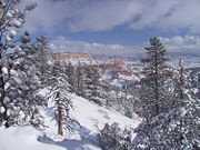
Most park visitors sightsee using the scenic drive, which provides access to 13 viewpoints over the amphitheaters.
Bryce Canyon has eight marked and maintained hiking trails that can be hiked in less than a day (round trip time, trailhead):[4]
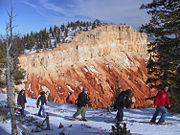
- Mossy Cave (one hour, State Route 12 northwest of Tropic), Rim Trail (5–6 hours, anywhere on rim), Bristlecone Loop (one hour, Rainbow Point), and Queens Garden (1–2 hours, Sunrise Point) are easy to moderate hikes.
- Navajo Loop (1–2 hours, Sunset Point) and Tower Bridge (2–3 hours, north of Sunrise Point) are moderate hikes.
- Fairyland Loop (4–5 hours, Fairyland Point) and Peekaboo Loop (3–4 hours, Bryce Point) are strenuous hikes.
Several of these trails intersect, allowing hikers to combine routes for more challenging hikes.
The park also has two trails designated for overnight hiking: the 9-mile (14 km) Riggs Loop Trail and the 23-mile (37 km) Under the Rim Trail.[4] Both require a backcountry camping permit. In total there are 50 miles (80 km) of trails in the park.
More than 10 miles (16 km) of marked but ungroomed skiing trails are available off of Fairyland, Paria, and Rim trails in the park. Twenty miles (32 km) of connecting groomed ski trails are in nearby Dixie National Forest and Ruby's Inn.

The air in the area is so clear that on most days from Yovimpa and Rainbow points, Navajo Mountain and the Kaibab Plateau can be seen 90 miles (140 km) away in Arizona.[14] On extremely clear days, the Black Mesas of eastern Arizona and western New Mexico can be seen some 160 miles (260 km) away.[14]
The park also has a 7.4 magnitude night sky, making it the one of the darkest in North America.[4] Stargazers can therefore see 7,500 stars with the naked eye, while in most places fewer than 2,000 can be seen due to light pollution (in many large cities only a few dozen can be seen). Park rangers host public stargazing events and evening programs on astronomy, nocturnal animals, and night sky protection. The Bryce Canyon Astronomy Festival, typically held in June, attracts thousands of visitors. In honor of this astronomy festival, Asteroid 49272 was named after the national park.[15]
There are two campgrounds in the park, North Campground and Sunset Campground.[14] Loop A in North Campground is open year-round. Additional loops and Sunset Campground are open from late spring to early autumn. The 114-room Bryce Canyon Lodge is another way to overnight in the park.[14]
A favorite activity of most visitors is landscape photography. With Bryce Canyon's high altitude and clean air, the sunrise and sunset photographs can be spectacular.
Gallery
References
- ↑ Kiver 1999, p. 523
- ↑ 2.0 2.1 Harris 1997, p. 44
- ↑ Tufts 1998, p. 71
- ↑ 4.0 4.1 4.2 4.3 4.4 4.5 4.6 4.7 The Hoodoo (Summer 2005)
- ↑ 5.0 5.1 5.2 5.3 5.4 5.5 Harris 1997, p. 46
- ↑ 6.0 6.1 Harris 1997, p. 53
- ↑ Harris 1997, p. 51
- ↑ Kiver 1999, p. 524
- ↑ Harris 1997, p. 50
- ↑ 10.0 10.1 10.2 10.3 10.4 NPS visitor's guide
- ↑ NPS website, Bryce Canyon (archived home page)
- ↑ "Bryce Canyon National Park: Utah Prairie Dog". National Park website. National Park Service, US Department of the Interior (22 February 2007). Retrieved on 17 November 2008.
- ↑ 13.0 13.1 NPS website, Reptiles and Amphibians
- ↑ 14.0 14.1 14.2 14.3 NPS website, Farview
- ↑ IAU: Minor Planet Center. "Discovery Circumstances: Numbered Minor Planets (45001)-(50000)". Retrieved on May 22, 2007.
Bibliography
- Harris, Ann G.; Tuttle, Esther; Tuttle, Sherwood D. (1997). Geology of National Parks (5th ed. ed.). Iowa: Kendall/Hunt Publishing. ISBN 0-7872-5353-7.
- Kiver, Eugene P.; Harris, David V. (1999). Geology of U.S. Parklands (5th ed. ed.). New York: Jonh Wiley & Sons. ISBN 0-471-33218-6.
- NPS contributors. Bryce Canyon visitors guide. Washington, D.C.: National Park Service. (public domain text)
- NPS contributors (Summer 2005). "Park Planner, Hiking and Shuttle Guide", The Hoodoo (Washington, D.C.), National Park Service.
- NPS contributors (2007). "Bryce Canyon National Park official website". Washington, D.C.: National Park Service. Retrieved on 2008-11-16.
- Tufts, Lorraine Salem (1998). Secrets in The Grand Canyon, Zion and Bryce Canyon National Parks (3rd ed. ed.). North Palm Beach, Florida: National Photographic Collections. ISBN 0-9620255-3-4.
Further reading
- DeCourten, Frank. 1994. Shadows of Time, the Geology of Bryce Canyon National Park. Bryce Canyon Natural History Association.
- Kiver, Eugene P., Harris, David V. 1999. Geology of U.S. Parklands 5th ed. John Wiley & Sons, Inc.
- Sprinkel, Douglas A., Chidsey, Thomas C. Jr., Anderson, Paul B. 2000. Geology of Utah's Parks and Monuments. Publishers Press.
External links
- Bryce Canyon National Park Service Info / US Department of the Interior.
- Bryce Canyon National Park: Hoodoos Cast Their Spell, a National Park Service Teaching with Historic Places (TwHP) lesson plan
- Bryce Canyon National Park travel guide from Wikitravel
- Bryce Canyon Country Garfield County Tourism Office
- Bryce Canyon National Park: Hoodoos Cast Their Spell: a lesson about Bryce Canyon National Park.
- Bryce Canyon Half Marathon July Festival and Race through scenic Bryce Canyon
|
|||||||||||
|
|||||||||||||||||||||||||||||
|

