Borneo
 Topography of Borneo |
|
| Geography | |
|---|---|
| Location | South East Asia |
| Archipelago | Greater Sunda Islands |
| Area | 743,330 km2 (287,000 sq mi) (3rd) |
| Highest point | Kinabalu (4,095 m/13,440 ft) |
| Country | |
| Districts | Belait Brunei and Muara Temburong Tutong |
| Provinces | West Kalimantan Central Kalimantan South Kalimantan East Kalimantan |
| States | Sabah Sarawak |
| Demographics | |
| Population | 16 million (as of 2000) |
| Density | 57/sq mi, 22 people/km2 |
| Ethnic groups | Dayak |
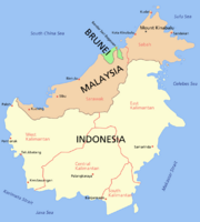
Borneo is the third largest island in the world and is located at the centre of Maritime Southeast Asia. Administratively, this island is divided between Indonesia, Malaysia and Brunei. Indonesians refer to the island as "Kalimantan." However, for people outside of Indonesia, "Kalimantan" refers to the Indonesian part of the island of Borneo. Malaysia's region of Borneo is called East Malaysia or Malaysian Borneo. The independent nation of Brunei occupies the remainder of the island. Brunei is the wealthiest nation in the island of Borneo.
Contents |
Geography
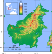
Borneo is surrounded by the South China Sea to the north and northwest, the Sulu Sea to the northeast, the Celebes Sea and the Makassar Strait to the east, and the Java Sea and Karimata Strait to the south. It has an area of 743,330 km² (287,000 square miles).
To the west of Borneo [1] are the Malay Peninsula and Sumatra. To the south is Java. To the east is the island of Sulawesi (Celebes). To the northeast is the Philippines.
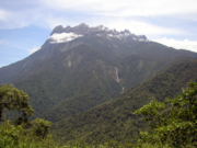
Borneo's highest point is Mount Kinabalu in Sabah, Malaysia, with an elevation of 4,095 m (13,435 ft) above sea level. This makes it the world's third highest island.
The largest river systems are the Kapuas River, with approximately 1,143 km (710 mi) the longest river in Indonesia, the Rajang River in Sarawak with some 562.5 km (349.5 mi) the longest river in Malaysia, the Barito River about 880 km (550 mi) long and the Mahakam River about 980 km (610 mi) long.
Borneo is also known for its extensive cave systems. Clearwater Cave has one of the world's longest underwater rivers. Deer Cave, thought to be the largest cave passage in the world, is home to over three million bats and guano accumulated to over 100 metres (330 ft) high.
Cities in Borneo by population and year estimation
- Kuching, (765,430 people) Sarawak (2008)
- Balikpapan, (722,810 people) and metropolitan (1,987,000 people) Kalimantan (2008)
- Kota Kinabalu, (549,880 people) and metropolitan (900,000 people) Sabah (2008)
- Sandakan, (436,098 people) Sabah (2008)
- Bandar Seri Begawan, (158,110 people) and metropolitan (483,000 people) Brunei (2008)
- Tawau, (248,011 people) Sabah (2008)
- Banjarmasin (247,000 people) Kalimantan (2008)
- Pontianak (233,880 people) Kalimantan (2008)
- Kuala Belait (98,116 people) and metropolitan (245,800 people) Brunei (2008)
- Miri (229,550 people) Sarawak (2008)
- Sibu (209,910 people) Sarawak (2008)
- Jerudong (94,899 people) metropolitan (483,000 people) Brunei (2008)
Administration
The Island of Borneo is divided administratively into:
- The Indonesian provinces of East, South, West and Central Kalimantan
- The Malaysian states of Sabah and Sarawak (the Federal Territory of Labuan is located on nearshore islands of Borneo, but not on the island of Borneo itself)
- The independent country of Brunei (main part and eastern exclave of Temburong)
History
According to ancient Chinese, Indian and Javanese manuscripts, western coastal cities of Borneo have become trading ports, part of their trade routes, since the first millenium.[1] In Chinese manuscripts, gold, camphor, tortoise shells, hornbill ivory, rhinoceros horn, crane crest, beeswax, lakawood (a scented heartwood and root wood of a thick liana, Dalbergia parviflora), dragon's blood, rattan, edible bird's nests and various spices were among the most valuable items from Borneo.[2] The Indians named Borneo as Suvarnabhumi (the land of gold) and also Karpuradvipa (the Camphor Island), which includes the western part of the island shared with Sumatra island. The Javanese named Borneo as Puradvipa, or the Diamond Island. Archaeological findings in the delta river of Sarawak reveal that the area was once a thriving trade center between India and China from the sixth century until about 1300 AD.[2] In the fourteenth century, part of Borneo were under the control of Majapahit kingdom as is written in Javanese Nagarakretagama document (circa 1365 AD). The name of a trading port city in Borneo is Tanjungpura in Nagarakretagama; the same name written in another Javanese Paraton document (circa 1355 AD).[2]
In the 15th century, the Majapahit rule exerted its influence in Borneo. Princess Junjung Buih, the queen of the Hindu kingdom of Negara Dipa (situated in Candi Agung area of Amuntai) married a Javanese prince, Prince Suryanata, and together they ruled the kingdom which is a tributary to the Majapahit Empire (1365). In this way, it became a part of Nusantara. Along the way, the power of Negara Dipa weakened and was replaced by the new court of Negara Daha. When Prince Samudra (Prince Suriansyah) of Negara Daha converted to Islam and formed the Islamic kingdom of Banjar, it inherited some of the areas previously ruled by the Hindu kingdom of Negara Daha.
The Brunei Sultanate during its golden age from the 15th to 17th centuries ruled a large part of northern Borneo. In 1703 (other sources say 1658), the Sultanate of Sulu received North Borneo from the Sultan of Brunei, after Sulu sent aid against a rebellion in Brunei. During the 1450s, Shari'ful Hashem Syed Abu Bakr, an Arab born in Johor, arrived in Sulu from Malacca. In 1457, he founded the Sultanate of Sulu; he then renamed himself "Paduka Maulana Mahasari Sharif Sultan Hashem Abu Bakr". Subsequently HM Sultan Jamalul Ahlam Kiram (1863-1881) the 29th reigning Sultan of Sulu leased North Borneo in 1878 to Gustavus Baron de Overbeck & Alfred Dent representing the British North Borneo Company [2] in what is now Sabah part of Malaysia. The company also exerted control on inland territories that were inhabited by numerous tribes. In the 19th Century coastal areas ruled by the Brunei Sultanate in the west of the island were gradually taken by the Brooke dynasty. [3]
By the 18th century, the area from Sambas to Berau were tributaries to the Banjar Kingdom, but this eventually shrunk to the size of what is now South Kalimantan as a result of agreements with the Dutch. In the Karang Intan Agreement during the reign of Prince Nata Dilaga (Susuhunan Nata Alam) (1808-1825), the Banjar Kingdom gave up its territories to the Dutch Indies which included Bulungan, Kutai, Pasir, Pagatan and Kotawaringin. Other territories given up to the Dutch Indies were Landak, Sambas, Sintang and Sukadana.
In the early 19th century, British and Dutch governments signed the Anglo-Dutch Treaty of 1824 to exchange trading ports under their controls and assert spheres of influences, in which indirectly set apart the two parts of Borneo into British and Dutch controlled areas. China has had historical trading links with the inhabitants of the island. Some of the Chinese beads and wares found their way deep into the interior of Borneo.
Moreover in the 19th century, the Dutch admitted the founding of district kingdoms with native leaders who were under the power of the Dutch (Indirect Bestuur). The Dutch assign a resident to head their rule over Kalimantan. List of the residents and governors of Kalimantan:
- C.A. Kroesen (1898), resident
- C.J. Van Kempen (1924), resident
- J. De Haan (1924-1929), resident
- R. Koppenel (1929-1931), resident
- W.G. Morggeustrom (1933-1937), resident
- Dr. A. Haga (1938-1942), governor
- Pangeran Musa Ardi Kesuma (1942-1945), Ridzie
- Ir. Pangeran Muhammad Noor (1945), governor
Since 1938, Dutch-Borneo (Kalimantan) was one administrative territory under a governor (Governor Haga) whose seat was in Banjarmasin. In 1957 following the independence of Indonesia, Kalimantan was divided into 3 provinces which is South Kalimantan, East Kalimantan and West Kalimantan. The province of Central Kalimantan separated from South Kalimantan to have their own territory in 1958.
During the Second World War, Japanese forces gained control of Borneo (1941–45). They decimated many local populations and Malay intellectuals, including the elimination of the Malay Sultanate of Sambas in Kalimantan [4]. Borneo was the main site of the confrontation between Indonesia and Malaysia between 1962 and 1966, as well as the communist revolts to gain control of the whole area. Before the formation of Malaysian Federation, the Philippines claimed that the Malaysian state of Sabah in north Borneo is within their territorial rights based on historical facts of the Sultanate of Sulu's leasing agreement with the North Borneo Company, is presently an unresolved claim against Malaysia. Several other territorial claims such as Sipadan were resolved at The Hague international courts.
Ecology
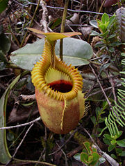
Borneo is very rich in biodiversity compared to many other areas (MacKinnon et al. 1998). There are about 15,000 species of flowering plants with 3,000 species of trees (267 species are dipterocarps), 221 species of terrestrial mammals and 420 species of resident birds in Borneo (MacKinnon et al. 1998). It is also the centre of evolution and radiation of many endemic species of plants and animals. The remaining Borneo rainforest is the only natural habitat for the endangered Bornean Orangutan. It is also an important refuge for many endemic forest species, as the Asian Elephant, the Sumatran Rhinoceros, the Bornean Clouded Leopard, and the Dayak Fruit Bat.
The World Wildlife Fund divides the island into seven distinct ecoregions. The Borneo lowland rain forests cover most of the island, with an area of 427,500 square kilometres (165,100 sq mi). Other lowland ecoregions are the Borneo peat swamp forests, the Kerangas or Sundaland heath forests, the Southwest Borneo freshwater swamp forests, and the Sunda Shelf mangroves. The Borneo mountain rain forests lie in the central highlands of the island, above the 1,000 metres (3,300 ft) elevation. The highest elevations of Mount Kinabalu are home to the Kinabalu mountain alpine meadow, an alpine shrubland notable for its numerous endemic species, including many orchids.
The island historically had extensive rainforest cover, but the area shrank rapidly due to heavy logging for the needs of the Malaysian plywood industry. Two forestry researchers of Sepilok Research Centre, Sandakan, Sabah in the early 80's indentified four fast-growing hardwoods and a breakthrough on seed collection and handling of Acacia mangium and Gmelina arborea, a fast growing tropical trees were planted on huge track of formerly logged and deforested areas primarily in the northern part of Borneo Island. One half of the annual tropical timber acquisition of the whole world comes from Borneo. Furthermore, Palm oil plantations are rapidly encroaching on the last remnants of primary rainforest. The rainforest was also greatly destroyed due to the forest fires in 1997 to 1998 which were started by people and coincided with an exceptional drought season of El Niño. During the great fire, hotspots could be seen on satellite images and a haze was created that affected Brunei, Malaysia, Indonesia and Singapore.
In order to combat overpopulation and AIDS in Java, the Indonesian government started a massive transmigration (transmigrasi) of poor farmers and landless peasants into Borneo in the 70's and 80's, to farm the logged areas, albeit with little success as the fertility of the land has been removed with the trees and what soil remains is washed away in tropical downpours.
Ethnic and biological diversity

There are over 30 Dayak sub-ethnic groups living in Borneo, making the population of this island one of the most varied of human social groups. The native ethnic groups are Dayak Austronesians and their languages belong to the Malayo-Polynesian language family. Some sub-ethnicities are now represented by only 30-100 individuals and are threatened with extinction. Much culture, language, ethnomusic and traditional knowledge has yet to be documented by anthropologists. Ancestral knowledge of ethnobotany [5] and ethnozoology [6] is useful in drug discovery (for example, bintangor plant for AIDS) or as future alternative food sources (such as sago starch for lactic acid production and sago maggots as a protein source).
Certain indigenous Dayak people (such as the Kayan, Kenyah, Punan Bah and Penan) living on the island have been struggling for decades for their right to preserve their environment from loggers and transmigrant settlers and colonists. Land reform is needed for future development in the face of rapid economic changes.
The type of rainforests found in Borneo include the high diversity mixed dipterocarp forest, the rare peat swamp forests and heath forest.
Researchers scouring swamps in the heart of Borneo island have discovered a venomous species of snake that can change its skin color. Scientists named their find the Kapuas mud snake, and speculated it might only occur in the Kapuas River drainage system.
World Wildlife Fund has stated that 361 animal and plant species have been discovered in Borneo since 1996, underscoring its unparalleled biodiversity. [7] In the 18 month period from July 2005 until December 2006, another 52 new species were found.
See also
- Borneo peat swamp forests
- Endemic birds of Borneo
- Fauna of Borneo
- Hikayat Banjar
- Islands of Indonesia
- Mammals of Borneo
- List of islands by area
- Rainforest World Music Festival
- Survivor: Borneo
References
- ↑ Derek Heng Thiam Soon (June 2001). "The Trade in Lakawood Products Between South China and the Malay World from the Twelfth to Fifteenth Centuries AD". Journal of Southeast Asian Studies 32 (2): 133-149. doi:.
- ↑ 2.0 2.1 2.2 Jan O. M. Broek (1962). "Place Names in 16th and 17th Century Borneo". Imago Mundi 16: 129-148. http://www.jstor.org/stable/1150309. Retrieved on 2008-10-28.
Further readings
- Bowen, M.R. and Eusebio, T.V. (1981) b): Acacia mangium. Updated information on seed collection, handling and germination testing. Occasional Tech. and Scientific Notes, Seed Series No.5, Forest Research Centre, Sepilok, Sandakan, Sabah, Malaysia
- Bowen, M.R. and Eusebio, T.V. (1982): Seed handling practices: four fast-growing hardwoods...Malaysian Forester Vol 45, No.4: 534-547
- Ghazally Ismail et al. (eds.) Scientific Journey Through Borneo Series. Universiti Malaysia Sarawak, Kota Samarahan. 1996-2001.
- Gudgeon, L. W. W. British North Borneo. Adam and Charles Black, London. (An early well-illustrated book on "British North Borneo", now known as Sabah.) 1913.
- MacKinnon K, Hatta G, Halim H, Mangalik A. The ecology of Kalimantan. Oxford University Press, London. 1998.
- K M Wong & C L Chan. "Mt Kinabalu: Borneo's Magic Mountain." Natural History Publications, Kota Kinabalu. 1998.
- David Macdonald. Expedition to Borneo.
- Dennis Lau. Borneo: A Photographic Journey.
- Stephen Holley. White Headhunter in Borneo.
- Robert Young Pelton Borneo.
- Mel White: " Borneo's moment of truth" National Geographic Magazine November 2008
Selected references
- Robert Young Pelton. Fielding's Borneo[8]
- Eric Hansen. Stranger in the Forest: On Foot Across Borneo.
- John Wassner. Espresso with the Headhunters: A Journey Through the Jungles of Borneo.
- Redmond O'Hanlon. Into the Heart of Borneo: An Account of a Journey Made in 1983 to the Mountains of Batu Tiban with James Fenton.
- Charles M. Francis. A Photographic Guide to Mammals of South-east Asia.
- Abdullah, MT. "Biogeography and variation of Cynopterus brachyotis in Southeast Asia." PhD thesis. The University of Queensland, St Lucia, Australia. 2003.
- Corbet, GB, Hill JE. The mammals of the Indomalayan region: a systematic review. Oxford University Press, Oxford. 1992.
- G.W.H. Davison, Chew Yen Fook. A Photographic Guide to Birds of Borneo.
- Hall LS, Gordon G. Grigg, Craig Moritz, Besar Ketol, Isa Sait, Wahab Marni and MT Abdullah. "Biogeography of fruit bats in Southeast Asia." Sarawak Museum Journal LX(81):191–284. 2004.
- Karim, C., A.A. Tuen and M.T. Abdullah. "Mammals." Sarawak Museum Journal Special Issue No. 6. 80: 221–234. 2004.
- Garbutt, Nick, and J. Cede Prudente. Wild Borneo: The Wildlife and Scenery of Sabah, Sarawak, Brunei, and Kalimantan. 2007.
- Mohd. Azlan J., Ibnu Maryanto, Agus P. Kartono, and MT Abdullah. "Diversity, Relative Abundance and Conservation of Chiropterans in Kayan Mentarang National Park, East Kalimantan, Indonesia." Sarawak Museum Journal 79: 251-265. 2003.
- Hall LS, Richards GC, Abdullah MT. "The bats of Niah National Park, Sarawak." Sarawak Museum Journal. 78: 255-282. 2002.
![[8]](http://g-ecx.images-amazon.com/images/G/01/ciu/05/5c/473f225b9da075a531691110._AA240_.L.jpg)
External links
- Environmental Profile of Borneo - Background on Borneo, including natural and social history, deforestation statistics, and conservation news.
- Official Sarawak Tourism site offering news, travel notes and articles about Sarawak.)
- Parchuting cats the story of WHO parachuting 14,000 cats into Borneo.
- Sabah Tourism Board Official Website, the premiere information hub of the Sabah tourism industry. (Sabah Malaysian Borneo)
- WWF Heart of Borneo conservation initiative - Information about the Heart of Borneo - 220,000 km2 (85,000 sq mi) of upland montane tropical rainforest, where endangered species such as the orang-utan, rhinoceros and pygmy elephant cling for survival.