Böblingen
| Böblingen | |
 |
|
| Coat of arms | Location |
 |
 |
| Administration | |
| Country | Germany |
|---|---|
| State | Baden-Württemberg |
| Admin. region | Stuttgart |
| District | Böblingen |
| Lord Mayor | Alexander Vogelgsang |
| Basic statistics | |
| Area | 39.04 km² (15.1 sq mi) |
| Elevation | 464 m (1522 ft) |
| Population | 46,419 (29/06/2006) |
| - Density | 1,189 /km² (3,080 /sq mi) |
| Other information | |
| Time zone | CET/CEST (UTC+1/+2) |
| Licence plate | BB |
| Postal codes | 71001–71034 |
| Area code | 07031 |
| Website | www.boeblingen.de |
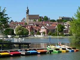
Böblingen is a city in Baden-Württemberg, Germany, seat of Böblingen District. Physically Sindelfingen and Böblingen are continuous.
Contents |
History
Böblingen was founded by Count Wilhelm von Tübingen-Böblingen in 1253. Württemberg acquired the town in 1357, and on 12 May 1525 one of the bloodiest battles of the Peasants' War took place in Böblingen. Georg III Truchsess von Waldburg attacked a force of 15,000 armed peasants; 3,000 were killed. By the end of the Thirty Years' War in 1648, the population of Böblingen had been reduced to 600.
After the establishment of the Kingdom of Württemberg, Böblingen became the seat of an Oberamt (administrative unit) in 1818. The town was connected to the railroad network in 1879, allowing industrialization to take place. In the context of administrative reform in 1938, Böblingen Oberamt became Böblingen Landkreis (district).
During the Second World War the town had a Luftwaffe airbase and military barracks. On September 1, 1939 (the day the war began) the airbase was the home station for the I/JG 52 (1st Group of the Jagdgeschwader 52) flying the Bf109 E-1 fighter aircraft.
On the night of October 7, 1943 during World War II, Allied air forces dropped 408 incendiary bombs and 35 high explosive bombs killing 20 men, 12 women, 12 children and wounding 200 people. 1,735 people lost their homes and 70 percent of the old town was destroyed. In July 1944 another attack followed, killing 36 more civilians.
In 1962, Böblingen was designated a Große Kreisstadt (major district town). Its current boundaries were established in 1971 when it was merged with the municipality of Dagersheim.
Population history
|
|
Transportation
Böblingen is easily reached by all forms of transportation
Air
Böblingen is about 20 minutes via S-Bahn from Stuttgart Airport.
Automobile
The interchange between the federal freeways (Autobahn) A 8 and A 81 lies not far northeast from Böblingen. A 81 leads past the north of the city. Use exits Böblingen Ost (East), Böblingen/Sindelfingen, Böblingen Hulb and Ehningen. Federal highways B 464 (Sindelfingen - Reutlingen) and B 14 run by the city.
Rail
Böblingen lies on the Gäubahn line (Stuttgart - Singen ). Regional trains serve the city every hour.
Local public transportation
Local public transportation within Böblingen operates under the uniform prices and coordination of the Verkehrs- und Tarif Verbund Stuttgart ("Stuttgart Transit and Fare Association", or VVS). The S1 "Plochingen–Stuttgart–Herrenberg" S-Bahn (suburban rail) line connects Böblingen with Stuttgart and its S-Bahn network. Travel time to Stuttgart is about 25 minutes.
In 1996 the Schönbuchbahn line to Dettenhausen was re-activated. In 2004 the reactivation of the Rankbachbahn line to Renningen began.
In addition to the main rail station, the following stations also serve the city: on S-Bahn line S1: Goldberg and Hulb; on the Schönbuchbahn line: Danziger Street, Böblingen Süd (South), Heusteig Street, and Zimmerschlag.
Numerous bus routes operate in the city, and are also under the VVS.
Military
There is a U.S. military base called Panzer Kaserne (translated as Tank Barracks), which serves as headquarters for Marine Corps Forces, Europe (MARFOREUR) since 1993 as well as Marine Corps Forces, Africa (MARFORAF) since 2008. This was a former German military installation during the Second World War.
Education
Education in Germany has two lower levels of school, Kindergarten and elementary school (Grundschule - grades 1–4), and three upper levels of school, Hauptschule (grades 5–9), Realschule (5–10) and Gymnasium (5–13). Teachers and parents decide at the end of the fourth grade which level of school the child should attend based on academic performance and aptitude.
In Boeblingen there are:
- Three Grund/Hauptschulen combination schools: Eichendorff Grund-und Hauptschule (GHS), Theodor Heuss GHS and Rappenbaum GHS.
- Two Realschulen, Albert-Schweitzer and Friedrich-Schiller; there are four Gymnasiums, Albert-Einstein, Lise-Meitner, Max-Planck and Otto-Hahn Gymnasium.
- Two special-needs schools (Pestalozzischule).
- Several vocational schools including: The Boeblingen Data Processing Academy, Boeblingen Commercial School, the Biotechnological High School and the Food Sciences High School.
- Seven independent primary schools: Eduard-Moerike, Erich-Kaestner, Friedrich-Silcher, Justinus-Kerner, Ludwig UHL, William Striking and Dagersheim.
- Other schools include: (loosely translated) The Private Old Person Care School of the Workers' Welfare Institution Nordwuerttemberg, The Free Evangelist School of Boeblingen, The Free Rudolf Steiner School of Boeblingen/Sindelfingen, and the Private Technical High School in the Education Center of Boeblingen of the International Federation.
- There is an American grade school, called Boeblingen elementary (On the American Army base of Panzer Kaserne).
Museums
- Tenth-scrub (1593 build), includes today the Boeblingen urban gallery and the farmer war museum (with tin figure diorama and many text boards).
- German butcher museum, in a half timbered house (painted walls on the inside).
Buildings
- The Evangelist parish church at the market place is the landmark of the city. The church was destroyed in the Second World War and rebuilt again after the war.
- Water Tower Böblingen-Waldburg
- Brothel C33
- Disused Böblingen airport: famous for a brief flying visit by Hitler.
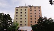
- Orplid - an apartment high-rise built by Hans Scharoun, proponent of Organic architecture
Events
- Several fairs around the marketplace/Schlossplatz and the lakes (e.g. Town fair „Böblinger Jahrmarkt“ in July, wine festival in September and Christmas Market in December).
- Since 1996: every year “Böblinger Sommer am See” (lit. Summer at the lake) from June to September. There are over 60 events (e.g. concerts, flea market) taking place around the two lakes in Böblingen.
- At regular intervals concerts and other events happen at the Stadthalle (town hall) and at the Congress Centrum (Congress centre), like the Wetten, dass..? show, and concerts by international pop and rock stars.
Business
The Böblingen/Sindelfingen area is the location of several large enterprises:
- Agilent (Electronic Test and Measurement)
- Avago Technologies (Semiconductors)
- Daimler AG (Automobiles)
- Hewlett-Packard (Computers, Software and Services)
- IBM (Computers, Software and Services)
- NXP (Semiconductors)
- Philips (Medical Monitors)
- Verigy (Semiconductor Test)
- Softpro (Electronic Signature Verification)
Böblingen/Sindelfingen can be called a center of both automobile and computer industries. Daimler develops and manufactures its Mercedes brand of luxury cars here.
Hewlett-Packard (and its offsprings) and IBM develop computer systems, software and electronic products in the area. Böblingen was once also a major center of European computer manufacturing, with an IBM semiconductor and printed-circuit fab and an HP computer systems manufacturing operation. Most of those electronics-production sites have either been closed or moved to other locations (such as nearby Herrenberg).
Twin towns
 Glenrothes, Scotland
 Pontoise, France
 Sittard-Geleen, Netherlands
 Bergama, Turkey
 Alba, Italy
 Sömmerda, Germany
References
External links
|
|||||||||||

|
|||||||