Battersea
| Battersea | |
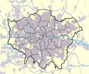 Battersea shown within Greater London |
|
| OS grid reference | |
|---|---|
| London borough | Wandsworth |
| Ceremonial county | Greater London |
| Region | London |
| Constituent country | England |
| Sovereign state | United Kingdom |
| Post town | LONDON |
| Postcode district | SW11 |
| Dialling code | 020 |
| Police | Metropolitan |
| Fire | London |
| Ambulance | London |
| European Parliament | London |
| UK Parliament | Battersea |
| London Assembly | Merton and Wandsworth |
| List of places: UK • England • London | |
Battersea is a place in the London Borough of Wandsworth. It is an inner-city district located 2.9 miles (4.8 km) south west of Charing Cross. It has a population of 75,651 people (April 2001).[1]
Contents |
Geography
Battersea is an area of London lying on the south bank of the River Thames. Roughly triangular in shape, its northern boundary is the Thames, as it runs first north-east, and then east, before turning north again to pass Westminster. Its north eastern corner is one mile (1.6 km) due south of the Palace of Westminster; the north western corner is demarcated by Wandsworth Bridge and Battersea tapers south to a point roughly three miles (5 km) from the north eastern corner and two miles (3 km) from the north west.
Places of note
Within the bounds of modern Battersea are (from east to west):
- Battersea Power Station an impressive, now disused, edifice designed by Sir Giles Gilbert Scott, built between 1929 and 1939 (featured, with flying pig, on the sleeve art of Pink Floyd's album 'Animals'). Currently being renovated into a mass entertainments and commercial complex, with dedicated transport links. It is planned that the renovations will be completed in 2012. There is however scepticism locally that the plans will ever materialise, and there is opposition to them.
- Battersea Dogs and Cats Home, formerly Battersea Dogs Home and prior to that the Temporary Home for Lost and Starving Dogs, established in Holloway in 1860 and moved to Battersea in 1871. (Many would say this is located in Nine Elms)
- New Covent Garden Market, a major fruit and vegetable wholesale market, resited from Covent Garden in 1974. (Also considered by many to be in Nine Elms)
- Battersea Park, an 83 hectare green space laid out by Sir James Pennethorne between 1846 and 1864 and opened in 1858, and home to a zoo and the London Peace Pagoda.
- Sir Walter St John's School, now Thomas's day school, was founded in 1700. Parts of the present building date back to 1859.
- Price's Candles on York Road, was the largest manufacturers of candles in the UK; now it has been converted into residential flats.
- The London Heliport, London's busiest heliport, sited on the Thames a half mile due north of Clapham Junction station.
- Clapham Junction, claimed to be the busiest railway station in the United Kingdom and Europe.
- Royal Academy of Dance, containing several studios and associated with the University of Surrey.
- St Mary's Church, Battersea. Benedict Arnold is buried here. There are four spectacular stained glass windows, celebrating Arnold, William Blake, William Curtis and J. M. W. Turner.
History
The area takes its name from the old village of Battersea, an island settlement established in the river delta of the Falconbrook; a river that rises in Tooting Bec Common and flows underground through south London to the River Thames.[2]. The site of the original settlement is marked by St. Mary's Church. William Blake was married, and Benedict Arnold and his wife and daughter are buried in the crypt of the church. Battersea is mentioned in Anglo-Saxon time as Badrices īeg = "Badric's Island" and later "Patrisey". As with many former Thames island settlements, Battersea was reclaimed by draining marshland and building culverts for streams.
The settlement appears in the Domesday Book as Patricesy. It was held by St Peter's Abbey, Westminster. Its Domesday Assets were: 18 hides; 7 mills worth £42 9s 8d, 17 ploughs, 82 acres (330,000 m2) of meadow, woodland worth 50 hogs. It rendered (in total): £75 9s 8d.[3]
Following her husband's death in 1890, Charlotte Despard devoted her time and money to helping the poor of Little Ireland in Nine Elms, Battersea.[4]
Industry
Before the industrial revolution, much of the area was farmland, providing food for the City of London and surrounding population centres; and with particular specialisms, such as growing lavender on Lavender Hill (nowadays denoted by the road of the same name) or pig breeding on Pig Hill (later the site of the Shaftesbury Park Estate). Villages in the wider area - Battersea, Tooting, Wandsworth, Balham - were isolated one from another; and throughout the second half of the second millennium, the wealthy built their country retreats in Battersea and neighbouring areas.
Industry in the area was concentrated to the north west just outside the Battersea-Wandsworth boundary, at the confluence of the River Thames, and the River Wandle which gave rise to the village of Wandsworth. This was settled from the 16th century by Protestant craftsmen - Huguenots - fleeing religious persecution in Europe, who established a range of industries such as mills, breweries and dying, bleaching and calico printing. Industry developed eastwards along the bank of the Thames during the industrial revolution from 1750s onwards; the Thames provided water for transport, for steam engines and for water intensive industrial processes. Bridges erected across the Thames encouraged growth; Putney Bridge, a mile (1.6 km) to the west, was built in 1729, and Battersea Bridge in the centre of the north boundary in 1771. Inland from the river, the rural agricultural community persisted.
Along the Thames, a number of large and, in their field, pre-eminent firms grew; notably the Morgan Crucible Company, which survives to this day and is listed on the London Stock Exchange; Price's Candles, which also made cycle lamp oil; and Orlando Jones' Starch Factory. The 1874 Ordnance Survey map of the area shows the following factories, in order, from the site of the as yet unbuilt Wandsworth Bridge to Battersea Park: Starch manufacturer; Silk manufacturer; (St. John's College); (St. Mary's Church); Malt house; Corn mill; Oil and grease works (Prices Candles); Chemical works; Plumbago Crucible works (later the Morgan Crucible Company); Chemical works; Saltpetre works; Foundry. Between these were numerous wharfs for shipping.

In 1929, construction started on Battersea Power Station, being completed in 1939. From the late 18th century to comparatively recent times, Battersea, and certainly north Battersea, was established as an industrial area, with all of the issues associated with pollution and poor housing affecting it.
Industry declined and moved away from the area in the 1970s, and local government sought to address chronic post-war housing problems with large scale clearances and the establishment of planned housing. More recently, some decades after the end of large scale local industry, residential overspill from fashionable Chelsea, the area to the north across the Thames, has changed the character of much of Battersea. Factories have been demolished and replaced with apartment buildings. Many of the council owned properties have been sold off and many traditional working men's pubs have become more fashionable bistros, although much local authority housing (including estates of considerable notoriety such as the Winstanley) and land in industrial use still remains.
Railway age
Battersea was radically altered by the coming of railways. The London and Southampton Railway Company was the first to drive a railway line from east to west through Battersea, in 1838, terminating at Nine Elms at the north west tip of the area. Over the next 22 years five other lines were built, across which all trains from Waterloo Station and Victoria Station ran. An interchange station was built in 1863 towards the north west of the area, at a junction of the railway. Taking the name of a fashionable village a mile and more away, the station was named Clapham Junction. During the latter decades of the nineteenth century Battersea had developed into a major town railway centre with two locomotive works at Nine Elms and Longhedge and three important motive power depots (Nine Elms, Stewarts Lane and Battersea) all situated within a relatively small area in the north of the district. The effect was precipitate: a population of 6,000 people in 1840 was increased to 168,000 by 1910; and save for the green spaces of Battersea Park, Clapham Common, Wandsworth Common and some smaller isolated pockets, all other farmland was built over, with, from north to south, industrial buildings and vast railway sheds and sidings (much of which remain), slum housing for workers, especially north of the main east–west railway, and gradually more genteel residential terraced housing further south.
The railway station encouraged the government to site its buildings - the town hall, library, police station, court and post office - at what became known as Clapham Junction; the Arding and Hobbs department store, diagonally opposite the station, was the largest of its type at the time of its construction in 1885; and the area was served by a vast music hall - The Grand - opposite the station and nowadays serving as a nightclub and venue for smaller bands.
Politics
The tradition of local government in the United Kingdom was based on the Parish. Population growth in the 18th century demanded new arrangements, and the Metropolitan Borough of Battersea was created in 1899, with the boundaries described above. It was in 1965 combined with the neighbouring Metropolitan Borough of Wandsworth to form the London Borough of Wandsworth. The former Battersea Town Hall, opened in 1893, is now the Battersea Arts Centre.
In the period from 1880 onwards, Battersea was known as a centre of radical politics in the United Kingdom. John Burns founded a branch of the Social Democratic Federation, Britain's first organised socialist political party, in the borough and after the turmoil of dock strikes affecting the populice of north Battersea, was elected to represent the borough in the newly formed London County Council. In 1892, he expanded his role, being elected to Parliament for Battersea North as one of the first Independent Labour Party member of Parliament.
Battersea's radical reputation gave rise to the Brown Dog affair, when in 1904 the National Anti-Vivisection Society sought permission to erect a drinking fountain celebrating the life of a dog killed by vivisection. The fountain, forming a plinth for the statue of a brown dog, was installed near in the Latchmere Recreational Grounds, became a cause célèbre, fought over in riots and battles between medical students and the local populace until its removal in 1910.
The borough elected the first black mayor in 1913 when John Archer took office, and in 1922 elected the Bombay-born Communist Party member Shapurji Saklatvala as MP for Battersea.
The Member of Parliament for the Battersea constituency since 1997 has been Labour's Martin Linton.
In pop culture
Battersea appears in Morrissey's song "You're the One for me Fatty" (he sings "all over Battersea, some hope and some despair"). Battersea is a title of a Hooverphonic song, and also appears in a title of a Super Furry Animals' song - "Battersea Odyssey". Babyshambles have a song titled "From Bollywood to Battersea". Battersea features in the books of Michael de Larrabeiti, who was brought up in the area: A Rose Beyond the Thames recounts the working-class Battersea of the 1940s and 1950s; The Borrible Trilogy presents a fictional Battersea, home to the Borribles.
Nearby places
- Clapham
- Wandsworth
- Vauxhall
- Chelsea
- Stockwell
- Earlsfield
- Fulham
Theatres
- Theatre 503
- Battersea Arts Centre
- The headquarters of Youth Music Theatre: UK are based in Battersea
Railway stations
- Battersea Park
- Clapham Junction
- Queenstown Road
- Wandsworth Road
- Battersea North (proposed)
- Battersea (a station on the proposed London Underground Chelsea-Hackney line)
Former Railway stations
- Battersea (closed 1940)
- Battersea Park Road (closed 1916)
References
- ↑ Battersea Profile, from Wandsworth Primary Care Trust, citing Census 2001
- ↑ source:London Under London: A subterranean guide: Richard Trench and Ellis Hillman: ISBN 0-7195-5288-5
- ↑ Domesday Book for Surrey
Further reading
- Patrick Loobey, Battersea Past. Historical Publications Ltd., 2002. ISBN 0-948667-76-1
- Peter Mason, The Brown Dog Affair. Two Sevens Publishing, 1997. ISBN 0-9529854-0-3
- Martin Knight,Battersea Girl. Mainstream Publishing, 2006. ISBN 1-84596-150-1
External links
- Battersea - 1911 Encyclopædia Britannica article
- Community website for Lavender Hill, Battersea, SW11 | lavenderhill.co.uk
- Martin Linton, MP for Battersea
- Battersea in A short introduction to the history of the borough of Wandsworth from Wandsworth Council
- Battersea in the Story of Wandsworth from Wandsworth Council Museum
- Conservation Area Character Statements from Wandsworth Council, providing the history of many areas in and around Battersea
- Excerpts from Battersea Works 1856-1956, from the Morgan Crucible Company
- The Battersea Mural
|
|||||||||||||||||

|
||||||||