Batanes
| Province of Batanes | |
Provincial seal of Batanes |
|
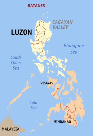 Map of the Philippines with Batanes highlighted |
|
| Region | Cagayan Valley (Region II) |
| Capital | Basco |
| Divisions | |
| - Highly urbanized cities | 0 |
| - Component cities | 0 |
| - Municipalities | 6 |
| - Barangays | 29 |
| - Congressional districts | 1 |
| Population | smallest |
| - Total (2007) | 16,467 |
| - Density | 79 /km² (205 /sq mi) (11th lowest) |
| Area | smallest |
| - Total | 209.3 km2 (81 sq mi) |
| Founded | — |
| Spoken languages | Ivatan, Ichbayaten, Isamurongen |
| Governor | Telesforo Castillejos (Lakas-CMD)/(Kampi) |
The Province of Batanes is the northernmost and the smallest province of the Philippine Republic, both in terms of population and land area. The provincial capital is Basco.
The province is composed of ten islands, called the Batanes Islands, located about 162 km north of the Luzon mainland in the Luzon Strait and is part of the Cagayan Valley region in Luzon. Of this island group, the largest and most economically important are Itbayat, Batan and Sabtang.
The Batanes Islands are separated from the Babuyan Islands of Cagayan Province by the Balintang Channel and from Taiwan by the Bashi Channel.
The northernmost island of the province, as well as of the Philippines, is Mavudis (Yami) Island. The other islands are Misanga, Ditarem, Siayan, Itbayat, Dinem, Batan, Sabtang, Ivuhos, and Diadekey.
Only Itbayat, Batan, and Sabtang are inhabited. The Batanes is about 190 kilometers south of Taiwan.
Contents |
History
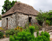
The ancestors of today's Ivatans are descended from Austronesians who migrated to the Batanes Islands 4000 years ago during the Neolithic period. They lived in fortified mountain areas called idjangs and drank sugar-cane wine, or palek. They also used gold as currency and produced a thriving agriculture-based industry. They were also seafarers and boat-builders.
In 1687, a crew of English freebooters headed by William Dampier came with a crew of Hollanders and named the islands in honor of their country's monarchs. Itbayat was named "Orange Isle" in honor of William of Orange, and Batan was named "Grafton Isle" after Henry FitzRoy, 1st Duke of Grafton. Sabtang Isle was named "Monmouth Isle" after the James Scott, 1st Duke of Monmouth. Capt. Dampier stayed for less than three months, and did not claim the islands for the British crown.

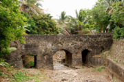
In 1783, the Spanish claimed Batanes as part of the Philippines under the auspices of Governor-General José Basco y Vargas. However, the Ivatan remained on their idjangs, or mountain fortresses. In 1790, Governor Guerrero ( The Governor-general of the Philippines at this point in time is Félix Berenguer de Marquina, unless Guerrero refers to a governor of the Batanes.) decreed that Ivatans were to leave their idjang and to live in the lowlands, thereby giving them more people to tax. Basco and Ivana were the first towns. Mahatao was then administered by Basco, while Uyugan and Sabtang, by Ivana. Itbayat was not organized until the 1850s, its coast being a ridge. Ivatans were then ordered to dress like the other Filipinos, and it didn't take them long to adapt. Soon, Ilocanos were being put in the islands, so as to control the native population there. Limestone technology used by the Spanish were also being spread to the islands, so that their bridges became strong and fortified. Some of these bridges still remain at both Ivana and Mahatao. By 1890, many Ivatans were in Manila, and became ilustrados, who then brought with them home the revolutionary ideas of the Katipunan. These Ivatans, who were then discontented with Spanish rule, killed the ruling General Fortea and declared the end of Spanish rule.
Toward the end of the Spanish regime, Batanes was made a part of Cagayan. In 1909, however, the American authorities organized it into an independent province. Because of its strategic location, the Batanes island group was one of the first points occupied by the invading Japanese imperial forces at the outbreak of the Pacific War.
During the American colonial period, public schools suddenly boomed, and more Ivatan became more aware of their place in the Philippines. One of the first School Superintendents was Victor De Padua, an Ilocano, who in 1942-45 during the Japanese occupation was made Provincial Governor. His descendants now live in the United States, Australia, Manila and Los Baños, Laguna, Philippines. In 1920, the first wireless telegraph was installed, followed by an airfield in 1930. Roads were constructed and the Batanes High School was instituted.
In the morning of December 8, 1941, the Batan Task Force from Taiwan landed on the Batan Islands, the first American territory occupied by the Japanese. Japanese fighters from these islands took part in the raid on Clark Air Base later that same day.
During the Second World War, the Japanese army had committed atrocities against the Ivatan. When the United States regained the country, Batanes regained its provincehood.
Beginning in 1945 liberated by the Philippine Commonwealth forces landing at Batanes were attacked by Japanese forces in the island during the Battle of Batanes.
On July 23, 2007, a magnitude-5.2 quake rocked Batanes, but no damage or casualty was immediately reported. The United States Geological Service (USGS)(www.usgs.gov), said the quake was recorded at about 10:58 a.m., with the epicenter at 40 km south of Basco town in Batanes, about 250 km northeast of Laoag, Ilocos Norte; or 560 km south of Taipei, Taiwan.[1]
On June 1, 2008, a magnitude 6.3 earthquake struck the seabed off of the coast of Batanes, but neither injuries nor damage was reported.[2]
People and culture
The indigenous people of the Batanes are called Ivatan (a native name in the Batan Islands) and share prehistoric cultural and linguistic commonalities with the Babuyan on Babuyan Island and the Tao people of Orchid Island. With the exception of Spanish ancestry introduced to the Ivatan and Babuyan over the centuries, the Ivatan, Babuyan, and Tao peoples are racially the same.
This divided nation is a result of the Dutch invasion of 1642. The northern half of the Ivatan homeland, Formosa and Orchid Island which were formally part of the Viceroyalty of New Spain, fell to the Dutch who were in turn expelled in 1662 by forces of the Chinese Ming Dynasty, led by the Chinese pirate Koxinga who then set himself up as The King of Taiwan.

The southern half of the Ivatan homeland, the islands of the Batanes, was reinforced and fortified by Spanish refugees from Formosa before being formally joined in the 18th century with the Spanish government in Manila.
The main languages spoken in Batanes are Ivatan, which is spoken on the islands of Batan and Sabtang, and Ichbayaten, which is spoken primarily on the island of Itbayat. The Ivatan which is dominant in the province is considered to be one of the Austronesian languages. From college level down to elementary level, the dialect is widely spoken.[3]
Political
Batanes is subdivided into 6 municipalities.
Batanes has only one congressional district.
Municipalities
|
|
Geography
Topography
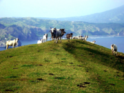
Batanes lies on a group of islands collectively called Batanes Islands and they are the northernmost islands of the Philippines. They are located between the Babuyan Islands (belonging to Cagayan Province) and Taiwan. The islands are sparsely populated and subject to frequent typhoons.
The three largest islands are Itbayat, Batan, and Sabtang. The northernmost is Mavudis Island.
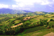
Almost one-half of Batanes are hills and mountains. Batan Island, with a land area of 35 km², is generally mountainous on the north and southeast. It has a basin in the interior. Itbayat Island, which has a total area of 95 km², slopes gradually to the west, being mountainous and hilly along its northern, eastern coast. As for Sabtang, mountains cover the central part of its 41 km² area, making the island slope outward to the coast.
The islands are situated between the vast expanse of the waters of Bashi Channel and Balintang Channel, where the Pacific Ocean, merges with the China Sea. The area is a sealane between the Philippines and Japan, China, Hongkong and Taiwan. It is rich with marine resources, including the rarest sea corals in the world.
The province is hilly and mountainous, with only 1,631.50 hectares or 7.10% of its area level to undulating and 78.20% or 17,994.40 hectares varying in terms from rolling to steep and very steep. Forty two percent (42%) or 9,734.40 hectares are steep to very steep land.
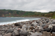
Because of the terrain of the province, drainage is good and prolonged flooding is non-existent. The main island of Batan has the largest share of level and nearly level lands, followed by Itbayat and Sabtang, respectively. Itbayat has gently rolling hills and nearly level areas on semi-plateaus surrounded by continuous massive cliffs rising from 20-70 meters above sea level, with no shorelines. Sabtang on the other hand, has its small flat areas spread sporadically on its coasts, while its interior is dominated by steep mountains and deep canyons. Batan Island and Sabtang have intermittent stretches of sandy beaches and rocky shorelines.
The terrain of the province while picturesque at almost every turn, has limited the potential for expansion of agriculture in an already very small province.
Climate
The climate is similar to that of Taiwan. Sometimes the island experiences below the normal low of 55 degrees Fahrenheit (13 °C).
The province is constantly swept by wind and rain, giving the misconception that Batanes is constantly being battered by typhoons. If Batanes is always mentioned in connection with weather disturbances, it is because its capital, Basco, holds the last weather station in the north. It is a reference point for all typhoons that enter the Philippine area of responsibility. It has no pronounced wet or dry season. It is almost always raining, from the minimum of eight days to a maximum of 21 days a month. It enjoys practically four seasons, the best ones being summer (April-June) and winter (December-February), when the temperature dips as low as seven degrees Celsius.
The best time to visit is mid-March to June. An Indian summer supposedly takes place in September. Sometimes, the weather is nice as early as February and as late as July. North or east winds bring in cooler air. They also bring in weather fronts and cloud build-ups that could cause flight cancellations. Cool weather—a phenomenon Ivatans like to call winter—prevails from December to February. When dealing with Batanes, always remember that, on these islands, the weather often changes suddenly. Just be ready for whatever heads your way.
Economy
About 75% of the Ivatans are farmers and fishermen. The rest are employed in the government and services sector. Garlic and cattle are major cash crops. Ivatans also plant camote (sweet potato), cassava, gabi or tuber and a unique variety of white uvi. Sugarcane is raised to produce palek, a kind of native wine, and vinegar.
In recent years, fish catch has declined due to the absence of technical know-how. Employment opportunities are scarce. Most of the educated Ivatans have migrated to urban centers or have gone abroad.
A wind diesel generating plant was commissioned in 2004.
Distance and bad weather work against its economic growth. Certain commodities like rice, soft drinks, and gasoline carry a 75% to 100% mark-up over Manila retail prices.
Approved symbols
- Provincial Tree: Aryus
- Provincial Flower: Rahakut (native white orchid)
- Provincial Bird: Aradiwangan, Voyit (Ivatan dove)
- Provincial Fish: Mayasang
- Provincial Air Plant: Humahum (fern)
- Provincial Song: Kalusan
References
External links
- Batanes Community Website
- Batanes Islands
- Official Government Web Site
- Batanes Travel and Tours
- Northern Luzon cultures
- Brief Overview of Batanes Islands
- Uyugan, Batanes! On the Web!
- Official Web Site
- GmaNews.tv, VIDEO, Kapuso Mo, Jessica Soho: Batanes 12/08/2007 | 10:21 PM
- Blog Post featuring Batanes
|
|||||