Basilan
| Province of Basilan | |
Provincial seal of Basilan |
|
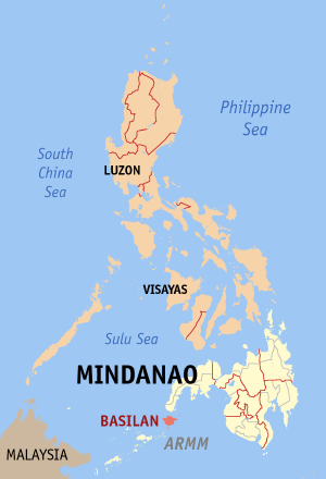 Map of the Philippines with Basilan highlighted |
|
| Region | Autonomous Region in Muslim Mindanao (ARMM) |
| Capital | Isabela City (Zamboanga Peninsula) |
| Divisions | |
| - Highly urbanized cities | 0 |
| - Component cities | 2 |
| - Municipalities | 11 |
| - Barangays | 255 |
| - Congressional districts | 1 |
| Population | 20th smallest |
| - Total (2007) | 496,503 |
| - Density | 402.287 /km² (1,042 /sq mi) (18th smallest) |
| Area | 8th smallest |
| - Total | 1,234.2 km2 (477 sq mi) |
| Founded | December 27, 1973 |
| Spoken languages | Yakan, Tausug, Chavacano, Cebuano, Banguingui |
| Governor | Jum Jainuddin-Akbar (Lakas-CMD) |
Basilan (Officially: Province of Basilan; Fil. - Lalawigan ng Basilan; Span. - Provincia de Basilan) is an island province of the Philippines most of which is located within the Autonomous Region in Muslim Mindanao (ARMM), except its capital, Isabela City, which is administered as part of the Zamboanga Peninsula Region. Basilan is located just off the southern coast of Zamboanga Peninsula. Basilan is the biggest and northernmost among the major islands of the Sulu Archipelago.
Basilan, although classified as a 4th-Class Province in terms of gross provincial income, is the only Province within the ARMM which is included in the Philippines' Top 20 Richest Provinces, having consistently showed one of the lowest poverty incidence of only 26.19% of the general population, ranked 20 among the Philippines' 81 Provinces (in comparison, Sulu which is ranked last at no. 81 has a poverty incidence of 63.24%). More importantly, the gap between Basilan's rich and poor residents are among the narrowest in the country (ranked 3rd nationwide), pointing to one of the most equitable distributions of wealth anywhere in the country (GINI Coefficient 0.2826, which is slightly better than the Provinces of Pampanga, Bulacan, Nueva Ecija, Tarlac, Cavite, Batanes and Batangas).
Contents |
Etymology

Pre-Hispanic texts from Royal archives of the Sulu Sultanate referred to the northernmost island of the Sulu Archipelago as Taguima (fr. Taguime) from the Yakan who were called "Tagihamas" (people of the interior or hinterlands) by the Tausug and Samal (who came and settled in numerous but scattered communities strung along Basilan's western and southwestern shores and outlying islets and island groups).
Later references pointed to a place called "Bantilan", probably referring to Maluso, which was established as a major Tausug base by Sulu Sultan Muizz ud-Din (whose princely name was Datu Bantilan).
Imperial Chinese texts, however, are widely agreed to have been in contact with a "Kingdom of Kumalarang" during the Ming Dynasty, which is also believed to be the self-same island which now has a Barangay of the same name on its northwestern shores.
The earliest map of the Philippines which made reference to an island labeled "Taguima" was by Giacomo Gastaldi,[1] through woodblock prints in 1548 and subsequently published in the influential travel book of Giovanni Battista Ramusio the "Della Navigatione e Viaggi" published between 1556 & 1583 in 3 volumes. This was followed by Abraham Ortelius in his work "Indiae Orientalis Insularumque Adiacientium Typus" published 1573 in a German text edition of the Atlas "Theatrum Orbis Terrarum" at Christopher Platin in Antwerp, Belgium. As late as 1719,[2] a map titled "Die philippinische Inseln - Isle Brneo" by Allain Manesson Mallet of Frankfurt, Germany was published which mentions an island still called "Tagyma I."
Renaming Taguima
How all these were eventually changed to Basilan is, as is the norm among most of the Philippines' place names, simple miscommunication between the natives and the Spanish (who probably meant well but heard wrong), Royal dynastic politics in Madrid, as well as the penchant to engage in editorial license by European map-makers of the aforesaid era.
Quite poignantly, as though a harbinger of its violent and colorful history, Basilan's name is derived from its iron ore deposits turned into elegant weapons - blades and knives - which used to be plainly abundant in that period of swashbuckling Conquistadores and Tausug pirates and slave-raiders.

Pioneering Tausug warriors and slave-traders from Sulu, came to Taguima to purchase high-quality iron ores which were brought back to Sulu and turned into swords and blades crafted by local smiths. This profitable trade in iron ore, helped in large measure by the establishment of Maluso as a major military-naval base of the Sulu Sultanate, eventually gave the island the distinction of being "the place to go for 'basih'", with 'basih' being the Tausug word for iron. Roughly translated therefore, "'Basih'-lan" means: "the iron trail" or "the iron way".
When several Tausug warriors were caught by the Spanish in one of their numerous raids on the Zamboanga settlement, Spanish officials supposedly admired the artistry and skill that went into making the warriors' elaborately decorated swords, knives and blades, and asked where these weapons could be bought. From atop the ramparts of the Spanish commandery at the '’Fuerza del Nuestra Senora del Pilar de Zaragoza (Fort Pilar), the warriors supposedly pointed to the island visible across today's Basilan Strait, and said, simply: "ha basih-lan".
Reports from the Jesuit mission in Zamboanga were relayed to Manila where Spanish Cartographer Pedro Murillo de Velarde published the "Historia de la Provincia de Philipinas de la Compañia de Jesvs. Segvnda parte" featuring a map of the Philippines with the as yet unofficial "I. Basilan". This was printed at the Jesuit printing press of Manila in 1749. The map was re-published by German (Leipzig) map-maker Nicolaus Bellinn for general European circulation in 1752, again carrying "I. Basilan".
Finally, to represent a clear break from the Habsburg Dynasty (which ruled Spain for 184 years from 1516 to 1700), the first officially sanctioned Spanish maps of its colonies, including "Las Islas de Mindanao," were commissioned by the Bourbons (1700-present). This particular map of Mindanao, apparently copied from the Nicolaus Bellinn map of 1752, was published by Nicolas Norton Nicols in 1757 featuring "Basilan" and bearing the royal stamp of Spanish Bourbon King Ferdinand VI. It has been called "Isla de Basilan" (Basilan Island) ever since.
Land
The province of Basilan has an aggregate historical jurisdiction of 135,892 hectares, with mainland Basilan encompassing an area of 124,892 hectares. The main island of Basilan is joined by the Pilas Group' of islands (now Hajji Muhtamad Municipality) west of the island, and the Bubuan and Tapiantana Group of islands (now Tabuan Lasa Municipality) in the south. These are listed among the Philippine islands with a moderate risk of getting hit by tsunamis.
Geography
Basilan is geographically located between latitude 6°15' and 7°00' longitude 121°15' and 122°30'.
Basilan is one of a system of 7,107 islands that make up the Philippine archipelago. Regionally, Basilan is the biggest and northernmost island of the Sulu Archipelago between the Philippine island of Mindanao and Borneo which includes about 400 islands. The island chain is one of two partial land bridges to Borneo and is an important migration route for birds. Basilan Strait, about 17 nautical miles at its narrowest point, separates Basilan Island from the mainland of Mindanao and the port city of Zamboanga.
The island is washed by the Basilan Strait from the North, the Sulu Sea from the Northwest and West, the Moro Gulf from the Northeast, and the Celebes Sea from the South, Southeast and East.
Natural resources

The island of Omosmarata in Tuburan (now Mohammad Ajul) is listed among only fifteen (15) sites in the Philippines with commercially viable ocean thermal energy potential. The Philippines' ocean thermal resource area is 1000 square kilometers, based on the archipelagic nature of the country. Based on a study, the potential capacity for this resource is estimated to be 265 million megawatts.[3]
Likewise, the Basilan Strait is listed among only eight (8) sites in the Philippines with commercially viable ocean tidal energy potential (along with Bohol/Talibon Strait, Basiao Channel, Surigao Strait, Gaboc Channel, Hinatuan Passage, San Bernardino Strait and San Juanico Strait).[4]
Only the Provinces of Basilan, Samar and Surigao have both high ocean thermal and ocean tidal energy potential for future development, a veritable gold mine in energy if properly harnessed.
Basilan likewise has fairly significant (yet underdeveloped) mineral deposits, specifically, iron ore ("basih"-lan), gold, manganese, copper, coal and rich agricultural lands.
Alienable and disposable lands cover 862.249 km2, forest lands occupy 406.526 km2, 294.194 km2 are underused, 574.85 km2 are under forest cultivation, while 689.479 km2 are under agricultural cultivation.
The Sulu Sea and Celebes Sea provides Basilan aquatic resources such as tuna, mackerel and sardines. Most of these are processed in canning factories located in nearby Zamboanga City, General Santos City (The Philippines' Tuna Capital), and Navotas.
Climate
The climatic condition is the same with other areas in the entire Zamboanga Peninsula. It has a “D” type of climate and rainfall is evenly distributed throughout the year. The annual average rainfall is 1,100 millimeters and mean annual temperature is 26.6° C. Source of rainfall is the southwest monsoon and intertropical convergence zone (mc).
Basilan, as part of Mindanao, is outside the typhoon belt. Prevailing winds are from the southwest with a speed of 4 knots.
Topography
The terrain is relatively plain with several undulating slopes (especially in Isabela City) along the coastal areas and hilly towards the interior. The tallest peak, Puno Mahaji or the Basilan Peak, is located in the southern half of the island and dominates the landscape. Urban areas are usually 2.5 meters above sea level and gently sloping to 300 meters toward the hinterlands.
People

Basilan has a median age of 19 years, a lot lower than the 1995 median age of 25 years.
The sex ratio is almost even. There were 166,413 males and 166,415 females in the 2000 CPH. However, there were more females in the age group 15 to 39 years and more males in all other age groups.
More than 55.2 percent belongs to the economically active population aged 15 to 64 years. About 42.3 percent are young dependents (aged 0 to 14 years) while less than three percent are old dependents (aged 64 years and over). The overall dependency ratio is 81.2. This means that for every 100 persons aged 15 to 64 years, there were about 77 young dependents and 4 old dependents.
Married persons accounted for 47.76 percent of the total persons 10 years old and over, lower than the 1995 figure (49.11 percent) by 1.35 percentage points. Single persons comprised 43.80 percent in 2000, from 45.71 percent in 1995. The widowed (4.49 percent) had less than one percentage point difference with the proportion registered in 1995 (3.89 percent). Those with other arrangements increased from 3.87 percent in 1995 to 4.49 percent in 2000.
Out of 60,710 housing units in Basilan, 60,699 units (99.98 percent) were occupied by 61,546 households. This rate of occupancy was higher than that of 1990 (95.6 percent). It recorded a ratio of 1.01 households for every occupied housing unit or 5.48 persons per occupied housing unit.

A large proportion (94.3 percent) of the occupied housing units in Basilan in 2000 were single houses. Three-fourths (75.9 percent) of the occupied housing units did not need repair or with minor repair while 17.8 percent needed major repair. One out of nine occupied housing units was built from 1996 to 2000.
The proportion of occupied housing units with roofs made of galvanized iron/aluminum rose from 23.1 percent in 1990 to 42.5 in 2000. On the other hand, roofs made of cogon/nipa/anahaw declined from 69.6 percent in 1990 to 50.3 percent in 2000. As to construction material of the outer walls, the use of wood rose by 10.2 percentage points, from 42.2 percent in 1990 to 52.4 percent in 2000.
Out of Basilan's estimated 60,582 families, 19,740 live in urban areas and 40,842 are rural. Average Poverty thresholds province-wide are pegged at Php9,271.00 as monthly family income, of which Php10,997.00 is considered the urban threshold and Php8,080.00 for rural families. 26.20% of the total population is below the poverty threshold, this comprises 36.50% of the urban population and 21.20% of the rural population. Poverty incidence is defined as the proportion of families whose income cannot provide for the basic food and non-food requirements called the poverty threshold to the total number of families. (magnitude of poor families / total number of families) X 100. Its a Human Development Index (HDI) of 0.425.
(The preceding figures are from the National Statistical Coordination Board - NSCB Philippine Database, Census of 2000[5] )
Culture

The three biggest cultural influences on the island are derived from the native Yakan, the Tausug and the Chavacano. Both Yakans and Tausugs are predominantly Muslim, while Chavacanos are primarily Christian. These three groups represent Basilan's tri-people community.
"The second center of Mohammedan population was found on the island of Basilan. It was ruled over in ancient times by the King of Taguima, who commanded a force of 5,000 armed Moros. Basilan contains an area of about 600 square miles and the population was distributed very sparsely through fifty Moro villages. From earliest times this island was a hotbed of bandits and pirates, and it was not until early in the twentieth century that American arms made it safe for travel. The island remained unknown in its entirety until Father Cavelleria sailed around it and mapped the coast in the year 1893."[6] - Swish of the Kris (The Seat of Moro Power)
Demographics
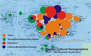
As the Jolo-based Tausug Sultanate grew in power, the native population of the island withdrew farther and farther inland, until most of the coastal communities which dotted the island's southern, western and northwestern shores were primarily inhabited by Tausugs and their vassal tribes, the Samals and Bajaus (Tau-Laut). The only exception was the relatively prosperous Yakan community of Lamitan.
The withdrawal of the Yakans inland was hastened even more so when the Spanish established advance bases on the island's northwestern coast, bringing in Christianized 'indios' from nearby Zamboanga, and as far as the Visayas and even Luzon. By then, even the Yakan communities of Lamitan were completely overrun.
By the eve of the Commonwealth era in the Philippines, local census estimates showed that a majority of the people of Basilan were Christian migrants, mostly plantation workers recruited from all over Mindanao and the Visayas, and Tausug traders, as well as Samal and Bajau fisherfolk. Only around 5,000 Yakans were counted in the census. Until then, most Yakans preferred not to inter-act directly with their lowland neighbors.
Currently, Basilan inhabitants include Christians and Muslims from a number of tribal groups such as the Yakans.[7], Tausugs, Chavacanos, Bisaya, Samal Bangingis, and to a much lesser extent by Ilonggos, Ilocanos, and Maranaos
Current census statistics show the following breakdown in demographics (2000 Census):
- Yakan (137,545 or 41.36%)
- Tausug (76,366 or 22.96%)
- Chavacano/Bisaya/Cebuano/Hiligaynon/Ilonggo/Ilocano/Ibanag (71,344 or 21.45%)
- Others/Samal/Bajao/Tagalog/Maranao/Maguindanao/Bikolano (46,174 or 14.23%)
Population growth

Basilan is experiencing a rapid increase in population growth rates. Comparative census results from 2000 and 2007, a period of only 7 years showed an actual increase of 164,857, from 331,646 (2000) to 496,503 (2007) or an increase of 49.7% in the last 7 years alone, an average increase of 7.1% annually.
In the City/Municipality level the increases are widely disparate. In Isabela City, the population growth is 20.47% (2.92% per annum; 73,032 in 2000, to 87,985 in 2007) which is slower when compared to the newly created Akbar Municipality, scene of many of the latest gun-battles between government troops and Moro separatist/extremist groups. The municipality's population growth is about 101.42% in the last seven years (14.48% per annum; 10,581 in 2000 to 21,312 in 2007).
Apart from Akbar municipality itself, the Akbar-controlled municipalities of Ungkaya Pukan grew by 89.74%, Muhammad Ajul by 79.72%, Lantawan (incl. Hji. Muhtamad) by 79.25%, Tipo-Tipo by 76.57%, Al-Barka by 63.86%, Maluso by 55.13%, and Tuburan by 52.03%.
Opposition bailiwicks Lamitan City grew by 39.80%, Sumisip (incl. Tabuan Lasa) by 38.85%, and Isabela City (under Akbar control in 2007 only) by 20.47%.
The average aggregate annual population increase in the 7-year period for the nine (9) municipalities and two (2) cities that comprise Basilan is a mind-boggling 9.12%. The average annual population growth rate of the rest of the Philippines is 2.3%.
These figures are verifiable from the National Statistics and Coordination Board and National Statistics Office of the Philippines.[8][9]
Religion


Basilan has a population that is 27% Christian (90% of whom are Roman Catholic) and 71% Muslim (nearly all are Sunni). Non-Catholic Christians identify with the Evangelicals, Episcopalian (Anglican Catholics), and Iglesia ni Cristo (INC), Mormons, Seventh Day Adventists, Jehovah's Witnesses, and a number of other Protestant denominations. Only the most recent Chinese immigrants exclusively adhere to Buddhism/Taoism, while most of the older Chinese families have acculturated and have either converted to Christianity or Islam while retaining most of their Chinese beliefs.

A majority of Basilan's Muslim population are concentrated mostly in the island's southern slopes. Christian residents, most of whom profess the Roman Catholic faith, usually reside in the urban centers of Isabela and Lamitan Cities on the island's northern coast, where they constitute a majority. Christian settlements are found in the former multi-national plantations, e.g., Tairan, Lantawan; Tumahubong, Sumisip; Maluso Townsite, Maluso. The rest have a mixture of both traditional and autochthonal beliefs.
The Prelature of Isabela de Basilan was created on October 12, 1963, and comprises all territories constituting the civil jurisdiction of Basilan Province, including Isabela City, its present capital. Its titular patron is Sta. Isabel de Portugal.[10]
Language
Chavacano is the lingua franca of Basilan, understood and spoken by nearly 80% of the residents both Christian and Muslim. Basilan has the biggest concentration of Chavacano speakers in the Philippines, outside of Zamboanga City.

Almost all residents also use Filipino/Tagalog as a second language. Tausug is also widely spoken and understood, especially among the Muslim tribes and is spoken and understood by approximately 70% of Basilan's population. Cebuano/Bisaya is a preferred third tongue among the Christian tribes and is spoken and understood by approximately 60% of all residents.
Yakan, although the acknowledged native dialect of Basilan, is used primarily by the Yakans alone (constituting 41% of the population), although it is also spoken and understood by about 15%-20% of the non-Yakan residents. An even lesser percentage can speak or understand Samal/Banguingui, Maranao, Ilocano and Ilonggo which are mostly confined to members of their respective tribes.
The educated classes, both Christian and Muslim, also use English for most official, business or government transactions. A dwindling group of native-Spanish speakers can still be found, nearly all of them are in Isabela and Lamitan Cities, and are usually members of the wealthy landowning class and/or descendants of expatriate plantation managers. Finally, Chinese/Fookien is used by the immigrant/naturalized Chinese community in the Province.
Education

Basilan has one of the lowest literacy rates in the Philippines. At a mere 69.4%, it is comparable to literacy rates in Sulu, as opposed to the national figure of 92.6%. School Year 2003-2004 figures show that grade school enrollment in public elementary schools are pegged at 43,581 pupils and are taught by 1,188 public school elementary teachers. Public high school students number 8,719 taught by 241 public secondary teachers.
The Island Province of Basilan has one (1) State College and five (5) private colleges. The Basilan State College is located in Isabela City and has an extension college in Lamitan City and Maluso.

Among the private higher education institutions in Isabela City, are the Claret College of Isabela (formerly Fatima High School), established by the Jesuits as the premier institution for Catholic education; the Juan S. Alano Memorial School, Inc., offering midwifery and other health-related courses since 1958, and affiliated with the Juan S. Alano Memorial Hospital, Inc., the first private health care institution in the province and the first non-sectarian School of Midwifery in Western Mindanao. Its campus is located at the Juan S. Alano Compound, Brgy. Doña Ramona T. Alano. It will soon be opening choice TESDA-accredited courses through a Technical Vocational Department. More recently, the pioneer computer school in Zamboanga Peninsula and the only computer college in Basilan - the Computer Technologies Institute (COMTECH) Inc. was established in 1997, located along N.S. Valderrosa Street.
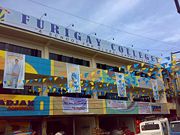
The schools in Lamitan City are Mindanao Autonomous College, founded in the year 2003. And the Mariam School of Nursing. The Mariam School of Nursing was established in 2004 as part of its Chairwoman's educational outreach program and was named Mariam or Mother Mary - a unifying and guiding figure among the Christians and Muslims. An I.T.-based College of Nursing located in Flores Street corner Rizal Avenue, it envisions to be recognized as a leading center for nursing and allied health education in the province. The newest school in Lamitan City would be the Furigay Colleges dubbed as "a school for global opportunities", opened its doors on June 2008, offering courses in B.S. Hotel Restaurant Management, Information Technology, Computer Science and Midwifery, as well as a number of TESDA-accredited courses.

Basilan is served by two School Divisions of the Department of Education, one for Basilan and one for Isabela City, though both are headquartered in Isabela City. A number of public and private high schools likewise dot the Province. The premier secondary educational institution on the Island is the Basilan National High School located in Isabela City, followed by the Lamitan National High School in Lamitan City. The Claret High Schools of Isabela, Lamitan, Maluso and Tumahubong, and a number of Madaris provide private secondary instruction.
More than 42 percent of the population five years old and over had attended or completed elementary education. Only 17.3 percent had attended or completed high school while 1.5 percent had attended or finished post secondary education. Less than three percent are academic degree holders while 6.2 percent were college undergraduates. A very insignificant number pursued post-baccalaureate studies. There were more males than females among those who had attended or finished elementary (51.1 percent), high school (50.3 percent), among college undergraduates (52.0 percent) and had attended post baccalaureate courses (58.4 percent). On the other hand, there were more females who had attended/completed post-secondary courses (52.9 percent) and were academic degree holders (52.34 percent).
Economy

Agriculture is the main source of economic livelihood. Basilan's major products include coconut (primarily copra), rubber, coffee, black pepper, and African palm oil. Other crops are palay, corn, cacao and cassava. The island’s waters produce grouper, tuna, squid, octopus, marlin and fishponds supply milkfish, prawn and shrimp. In addition, seaweed is cultivated along some coastal areas.
Local products also include intricately woven cloth and trinkets by members of the Yakan tribe. Yakans use fibers from plants such as pineapple for their crafts. The weavers traditionally used extracts from leaves, roots and barks to dye their fibers. However, contact with U.S. Peace Corps workers and Christian Filipinos has influenced Yakan textile art. One is influence is the introduction of chemical dyes.[7] The museum of Lamitan displays the colorful and intricate designs of the traditional Yakan textiles and highlights of the traditional Yakan Festival called the Lami-lamihan.
Historically, Basilan's economy has seen wild upswings and downturns over the course of several centuries. Pre-Hispanic Taguima had an economy based on basic subsistence agriculture, mostly root crops. Ancient Chinese texts point to the existence of a "Kingdom of Kumalarang" which presumably was located on the island's northwestern shore, and which traded occasionally with Chinese merchants plying the route to the Spice Islands of the Moluccas and Borneo farther south. Kumalarang was even recorded to have sent occasional tributes to the Chinese Emperor and his court, and even sent an embassy, headed no-less by its resident Datu all the way to the Chinese court in two instances.
By the arrival of the Spanish, other crops such as rice and corn were introduced and cultivated, primarily for the local consumption of the growing Christian settlements of Isabela and Lamitan. Trade with Zamboanga grew tremendously, as most of the needs of the settlers relied on regular shipments from the busy Zamboanga port.
The Multinational plantations

American occupation brought about the single biggest change in the local economy. By around 1914, Dr. James W. Strong, a pioneering American plantation owner, cleared vast tracts of land on the island's northern plains (Isabela/Lamitan), and established what eventually came to be the Philippines' first commercial rubber plantation-- the American Rubber Co. Upon consulting with Fr. Zamora a noted botanist of the University of Santo Tomas in Manila he decided to start experimenting with rubber plants and in 1910 formed the Basilan Rubber Plantation in partnership with J.M. Menzi Corporation as principal stock holders. Seven years later he sold out his interest to J.M. Menzi Corp. and started American Rubber Co. backed by San Francisco capital. He started building roads in Basilan with the help of his children of his first marriage mostly as truck drivers since such skills were not readily available at the time. Those roads are now part of the National Highway system in Basilan.
The family and plantation prospered and was frequently visited by such notables as Manuel L. Quezon President of the Commonwealth of the Philippines, his vice-president Sergio Osmena, General Douglas MacArthur and assorted Governor Generals and High Commissioners for the Philippines.
The plantation was eventually sold to American multi-national B.F.Goodrich. This was followed by investments from British-Malayan firm Sime Darby Corp., which opened their 4,000-hectare rubber plantation on the island's southern slopes (Sumisip/Tipo-Tipo).
The success of these large-scale cash crop plantations was emulated by a number of enterprising Filipinos and Spanish-mestizo families from Zamboanga, Negros and Luzon. Among these were Don Juan S. Alano, a Hispano-Chinese mestizo and native of Malolos, Bulacan, who opened the Philippine National Sugar Co. on Malamawi Island in 1921. This eventually became the Basilan Estates, Inc., the only wholly-owned Filipino plantation competing with American and British multi-nationals. It operated the Malamawi Island plantation which was converted to coconut/copra production, and opened a 3,800-hectare copra plantation on the island's western plains (Lantawan). American logging firm Weyerhaeuser Timber Co. and the American Lumber Co., opened large-scale logging concessions which operated in Basilan's extensive upland virgin forests. Menzi Corp., owned by Hispano-German J. M. Menzi, also opened an extensive rubber plantation in the southern part of Isabela which eventually expanded to black pepper and palm oil. The University of the Philippines was awarded with a 4,000 hectare land grant by the Philippine Government located in Sta. Clara, Lamitan.
When J. M. Menzi passed away, he was succeeded at the helm of his substantial business interests by his son and Marcos crony, Hans Menzi. When the younger Menzi replaced the plantation's Swiss-expatriate managers with local hires, these managers in turn opened up their own plantations elsewhere on the island.
Kurt Winniger, together with the Cuevas-Pamaran Clan of Lamitan, cleared up the Tumahubong, Sumisip area for a rubber plantation. Philip Boelsterli established yet another rubber plantation in the Mangal, Sumisip area. An American corporation opened the Yakan Plantation in Lamitan, and finally, a Filipino-American consortium opened another coconut plantation in the Canas, Maluso area.
By the 1950s and throughout the 1960s, the Chartered City of Basilan was classified as a first-class City. It exported copra, coconut oil, rubber and lumber directly to America's Pacific coast ports in California by way of Guam and Hawaii. Basilan's Isabela Municipal Wharf regularly had oceangoing vessels at dock, taking on Basilan's export produce which made Basilan the Philippines' biggest rubber producer and the country's second biggest coconut by-products exporter (next only to Quezon Province in Luzon). It likewise cornered the market for the nation's annual black pepper harvest, and was consistently at the top 10 biggest producers of cassava and palm oil.
A substantial number of expatriate plantation managers, mostly Americans (such as the families of McClintock, Cawley, Wallison, Robinson, etc.), but also Swiss (Winniger, Boelsterli), Germans (Menzi, Werble), Dutch and even Russian (Koslov) continued to live and inter-marry into the native populace.
The Weyerhaeuser Compound (now Tabuk Barangay) was an exclusive gated community for American expatriates living in Basilan, it had its own airstrip and wharf, and two-storey plantation-style villas set apart by expansive yards. The same sort of exclusive gated communities were put up at the Menzi Compound (Menzi Barangay) for the Swiss and German managers, and at the Alano Compound (Dna. Ramona T. Alano Barangay) as well, precursors of modern-day subdivisions.
The Moro uprising

The economic fortunes of the island took a severe nosedive when the Moro uprising of 1971, led by the maoist Moro National Liberation Front (MNLF) originating from Sulu, and led by leftist University of the Philippines lecturer Nur Misuari, infiltrated the plantations, burned entire Christian villages and terrorized the bigger coastal settlements with raids and bombing runs. This was compounded by the declaration of Martial Law by President Ferdinand Marcos in 1972, and the decree that effectively created Basilan Province, with its initial complement of 10 Municipalities (eventually reduced to seven).
By then, politics took center stage, and the resurgent Yakan uplanders found themselves battling the Tausug lowlanders and their allies. The incessant Yakan-Tausug pocket battles throughout the 1980s culminated in the burning of Isabela City's downtown market in 1987. After several revenge killings, Basilan gained notoriety as the Philippines' "Wild, Wild West". By then, Basilan's economy, along with the rest of the Philippines', was limping along, barely surviving the aftermath of these struggles.
CARP and the rise of the Abu Sayyaf
At the onset of the post-Marcos administration of Corazon Aquino, another blow was dealt to Basilan's economy. In 1988, Congress passed a law establishing the Comprehensive Agrarian Reform Program (CARP) which inaugurated the land distribution program, effectively dissolving nearly all corporate plantations on the island.
CARP, immediately covered Basilan's large multi-national plantations despite the plantation workers' misgivings and the landowners' objections. Almost immediately, the large multi-national corporations and all their investments were withdrawn from Basilan. Well-cultivated tracts of land were left to ill-trained, and ill-equipped farmer beneficiaries who managed operations in a farmers' cooperative format.
The J. S. Alano coconut plantation has since been converted to the Tairan Agrarian Reform Beneficiaries Association and Multi-Purpose Cooperative (TARBAMC), the University of the Philippines Basilan Land Grant into the Sta. Clara Agrarian Reform Beneficiaries Integrated Development Cooperative (SCARBIDC), the B.F. Goodrich and Sime Darby rubber plantations were merged and converted into the Latuan Agrarian Reform Beneficiaries Association Inc. (LARBAI). The vast tracks of the American-owned Yakan Plantation in Lamitan was first sold to then Defense Minister (and now Senator) Juan Ponce Enrile who established his Cocoland Plantation, this too was redistributed as the Lamitan Agrarian Reform Beneficiaries Cooperative (LARBECO). A number of other Agrarian Reform Beneficiaries' Cooperatives have likewise taken over most of the small to mid-sized plantations on the island.
By the early 1990s, disgruntled Yakan youth preached upon by returning mujahideen warriors from Afghanistan and schooled in Syria, Egypt and Pakistan, banded together to form the Al-Harakatul Al-Islamiyah, better known worldwide as the Abu Sayyaf, a Muslim extremist group advocating the delivery of Basilan into strict Islamic governance similar to Afghanistan's Taliban regime. Starting in earnest, this bandit group initiated test raids, kidnappings, ambushes and assassinations in some of the more vulnerable Christian communities inland, causing the dispersal of these communities and the total breakdown of the inland economy.
Inclusion in the ARMM and Balikatan 02-1
The Organic Act for the creation of the Autonomous Region of Muslim Mindanao (ARMM) was also passed into law in 1989. A plebiscite held in 14 Mindanao Provinces was held on the same year. Basilan initially opted out of the autonomous region. Only Maguindanao (without Cotabato City), Lanao del Sur (without Marawi City), Sulu and Tawi-Tawi joined the ARMM.
More than a decade later, in 2001, a new law expanding the ARMM was passed, and a plebiscite was subsequently held. While Basilan's five (5) Muslim municipalities (Maluso, Sumisip, Lantawan, Tipo-Tipo, Tuburan) opted to join the expanded ARMM, residents of the Christian areas of Isabela City and Lamitan Municipality, chose not to join the same. Even then, only Isabela was not included in the expanded ARMM, having been granted Cityhood earlier in the same year. Lamitan joined the five other municipalities as Basilan was officially enrolled into membership with the expanded ARMM.

Widespread corruption in the ARMM, helped in no small measure by corruption in the Municipal and Provincial levels further eroded business confidence in the island. This, plus the surge of terrorist activities by the Abu Sayyaf and their Jemaah Islamiyah (JI) cohorts in the international terrorist network of Al-Qaeda, effectively forced Basilan's economy to retreat further.
The Basilan hostage crisis of 2001 further raised questions about the economic future of Basilan. Operations by the militant Islamist extremist group Abu Sayyaf reduced prospects for investment and tourism. However, increased presence by the Philippine and U.S. military in the area through the Balikatan 02-1 Joint Military Exercises and the subsequent death of the Abu Sayyaf leaders Khadafi Abubakar Janjalani and Aldam Tilao (aka Abu Sabaya), have been followed by investments by the United States through USAID. Investments reportedly have created 40 new infrastructure projects in the conflict areas of Mindanao as of 2007.[11] Projects include the Basilan Tuburan Road Improvement Project and improvements to Lamitan and Maluso Ports.
Smaller barangay infrastructure projects intended to help boost economic growth are also under development. For instance, authorities are building farm-to-market roads, community and trade centers, water projects, and pedestrian bridges; according to USAID information.
A number of other ODA-funded Non-Government Organizations (NGOs) and People's Organizations (POs) flooded Basilan starting 2002. These NGOs and POs provided much-needed capital infusion for local entrepreneurs to restart defunct or dying business enterprises. Likewise, improved training and government-funded support were extended to decade-old Agrarian Reform Beneficiaries' Cooperatives, effectively improving productivity levels and crop yields. Extensive farm management training in these "Coop" areas have likewise improved business efficiency in the cooperatives.
Currently, Basilan's Minimum Wage is US$3.20/day for non-agriculture related jobs, and US$2.80/day for agriculture related jobs. There are only 1,203 registered Overseas Contract Workers from Basilan.
Return of rubber

By 2003, Basilan embarked on large-scale replanting programs covering some 50,000 hectares of privately-owned and/or cooperative-controlled lands, mainly for rubber and cassava. As of 2006, the province had 15,503 hectares planted, of which 7,148 hectares were owned by individual farmers and the rest by cooperatives. The exact land area devoted to rubber could reach over 20,000 hectares as there are hundreds of unrecorded small rubber growers and farmers.
Provincial government show that almost half or 7,029.47 hectares are immature, about a fifth or 3,143.36 hectares is classed as "less-productive", and a little under a third or 4,880.21 hectares is described as "productive."
A consortium of agrarian reform beneficiaries has been formed to improve quality and increase production. The Isla Corridor Consortium Agrarian Reform Communities not only sees itself as reviving the rubber industry, it also wants to help in the transformation of the battle-scarred province.
The consortium, composed of the United Workers Agrarian Reform Beneficiaries Multipurpose Cooperative, Lamitan Agrarian Reform Beneficiaries Cooperative, Sta. Clara, and the Latuan Agrarian Reform Beneficiaries Association, Inc., accounts for a total area of about 6,000 hectares, some 80% of which is planted with rubber trees.[12]
Coconut Crop

Still the biggest single crop produced in the Province, coconut/copra production is churning out an annual harvest of only 193,848 metric tons (2003) down from its peak production of 189,297,937 metric tons just two years before. Coconut plantations and small coconut farmers cover more than 12,000 hectares all of which are classified as "productive" to "mature" areas.
Coconut plantations have been rehabilitated starting 2006, owing to the steep rise in copra prices of late. A comprehensive replanting and rehabilitation program is currently being implemented by the Philippine Coconut Authority and the Department of Agriculture for the resuscitation of the island's copra production industry, once the Philippine's second-largest copra exporter after Quezon province in Luzon.
Comparative annual figures shows a drastic reduction in coconut production over the years which was 156,367,036 metric tons in 1999, 172,368,214 metric tons in 2000, and peaked at 189,297,937 metric tons in 2001. However, due to the lingering effects of CARP, combined with a severe onset of the El Niño weather pattern, the worsening peace and order condition brought about by the resurgent Abu Sayyaf terrorist group and their MILF allies, and the policy of the Akbar administration to cut down entire coconut plantations and replace these with rubber trees, province-wide coconut production, which still accounts 50%-60% of the Province's total economic activity has dropped precipitously to only 174,939 metric tons in 2002, slightly increasing to only 193,848 by 2003.
To date, coconut production in the Province, rapidly being replaced by rubber plantations, has remained in the doldrums. Basilan will find it hard to regain No. 2 status among the nation's coconut producers from here on despite the Government's best efforts to revive the ailing sector.
Coconut Farmers get incentives from PCA.[13]
Banking, Finance & Business Support
Banks based in Basilan have a total deposit base of more than Php764,500,000. Among the National commercial banks operating on the island are Metropolitan Bank & Trust Corp. (Metrobank), Allied Banking Corp. (Allied Bank), and Philippine National Bank (PNB) in Isabela City and the United Coconut Planters' Bank (UCPB) in Lamitan City. Government Banks include the Land Bank of the Philippines (Landbank) and the Development Bank of the Philippines (DBP). It hosts at least 27 distinct Pawnshop operations, each of whom has an average 3 branches, mostly located in the Cities of Isabela and Lamitan, and Maluso Townsite.
The Province is likewise serviced by satellite offices of vital Government Financing Institutions such as the Social Security System (SSS) and Government Service Insurance System (GSIS).
The Basilan business sector is represented by the Basilan Chamber of Commerce & Industry, Inc. (BCCI), organized in 1975, the only business support organization duly affiliated with the Philippine Chamber of Commerce & Industry, Inc. (PCCI), with 95% of its members being composed of Small and Medium Enteprises (SMEs), and offices mostly in the Cities of Isabela and Lamitan, but with business assets and operations ranging throughout the island. A number of smaller business groups have since been established catering to the needs of businessmen from specific ethnic or religious affiliations, i.e. Filipino-Chinese Chamber of Commerce & Industry, Inc. - Basilan Chapter (FilChi - Basilan); Autonomous Basilan Islamic Chamber of Commerce & Industry (ABICCI).
Utilities, Infrastructure & Health


Basilan's electricity needs are served by the Basilan Electric Cooperative (BASELCO), powered by three diesel-powered electricity generating plants located at Brgy. Binuangan, Isabela City, one National Power Corporation(NAPOCOR) diesel-powered barge located at Brgy. Tabuk, Isabela City, and a mini-hydroelectric plant located in Kumalarang, Isabela City. Although 225 Barangays are energized, only about 38% of these Barangays are sufficiently powered, most of these are located in the Cities of Isabela and Lamitan, and Maluso Municipality. Rates are currently pegged at US$0.824/kwH, one of the highest throughout the Philippines.
Basilan is likewise served by three local water utilities namely: Isabela City Water District (ISAWAD), Lamitan City Water District (LAMWAD), and Maluso Water District (MAWAD). Only 17,693 households, however, have full access to safe and potable water. Current rates are pegged at an average US$3.20/month (+US$0.0826/10 cu.m.)
The island is likewise served by the Provincial Telephone System (PTS) which has 600 land-line connections and connected with National Direct Dial (NDD) via PLDT. It is likewise served by major Mobile Telecommunications carriers Globe and Smart. It has 2 Wi-Fi Internet Service Providers, and numerous Internet Cafes.
National Roads (concrete, asphalt, gravel) total 131.92 km, while there are 795.8 km of Local Roads. There are 13 municipal and local ports, 3 of which have roll on-roll off capacity, and at least 10 private airstrips servicing small aircraft. Among the major bridges are the Marcos Bridge of Isabela City and the recently inaugurated Matarling Bridge (built through USAID funding) between Isabela City and Lantawan.
There are 394 Barangay Health Workers, 6,966 immunized children, and 7 hospitals. There are 4 private hospitals, namely: the Juan S. Alano Memorial Hospital, Inc. (formerly Basilan Hospital), Infante Hospital, Basilan Community Hospital all in Isabela City, and the Dr. Jose Ma. Torres Hospital in Lamitan City. This is augmented by 3 government-run hospitals, namely: Basilan General Hospital and Isabela City Infirmary, both located in Isabela City, and the Lamitan District Hospital in Lamitan City.
Tourism
There are various attractions in the island of Basilan. There are architectural landmarks such as the Santa Isabel Cathedral, the Calvario Peak on which the Chapel of Peace stands and the Kaum Purnak Mosque. Natural attractions can also be seen such as the lake in the Pinagayan fishing village, Sumagdang Beach and the waterfalls of the Kumalarang River. Various cultures can be visited such as the Badjao, the Yakan and the Muslim communities.[14]
History
Politics

Basilan's strange politics has been dictated by its economics. Whereas only 25% of the island's residents originate from Christian tribes in the Visayas and Luzon, this group owns 70% of the island's arable agricultural land (private ownership or cooperatives as farmer beneficiaries). The Yakan tribe comprising 45% of the island's population has full control of local governments outside of Isabela and Lamitan cities. The Tausugs, Samals and Bajaus, forming 30% of the population, control nearly 90% of the island's rich aquatic harvest. While the minuscule Chinese segment of the population controls nearly 100% of all commodity trading and commerce activities, especially in the bigger cities.
This volatile mix of different ethnic and religious groups have defined political realignments in the island for most of its history. The Christian tribes, traditionally allied with the Tausugs, controlled Basilan politics until the 1980s, when the Yakans, aided by their almost absolute control of the hinterlands and the disappearance of the multi-national plantations, scored upset victories in electoral contests starting in 1988.

Of late, a strengthening Yakan-Tausug alliance, brought about by the arrival of the Tableegh, fundamentalist Islamic preachers schooled by extremist Middle-Eastern clerics in Syria, Afghanistan and Egypt, has forged a more or less solid Muslim front which has succeeded in thwarting Christian economic and political interests on the island.
This political combine has since seen some in-fighting from two of the most formidable power blocks to have formed since the 2004 general elections. Both blocks went head-to-head in the 2007 local elections.
The Akbar block (Liberal Party - Atienza Wing), led by the late Wahab Akbar, 3-term Governor and alleged Abu Sayyaf co-founder, together with his wives, and his nephews and nieces, all of whom have been rewarded with a mayoralty post in all the Municipalities as well as the biggest electoral prize - Isabela City, which is under his second wife Cherrylyn Santos-Akbar. His first wife is currently the Governor of Basilan, Jum Jainuddin-Akbar. Wahab Akbar himself, was elected Congressman.
The Salapuddin Block (Lakas-CMD/Kampi), led by Abdulgani 'Gerry' Salapuddin, 3-term Governor, 3-term Congressman and 2-term Deputy Speaker of the House of Representatives, with his allies Hajiman Salliman Hataman of Sumisip and his brother, Anak Mindanao (AMIN) Party-list Representative Mujiv Hataman, along with a mix of Tausug and Christian leaders. To them, the 2007 elections proved to be a debacle as they lost in nearly all fronts, save for Lamitan City.
Both political coalitions are allied with the Administration of President Gloria Macapagal-Arroyo.
In November 13, 2007, a few months after having been elected Congressman, Wahab Akbar himself was killed by a bomb blast that exploded as he was about to leave the Philippine's Congress Building in Quezon City. Allegations behind the apparent assassination were leveled at Salapuddin and Hataman.
- GOVERNOR JUM J. AKBAR (1st Term, elected May 2007)
Governor: Jum Jainuddin-Akbar
Vice Governor: Al-Rasheed Sakkalahul
Provincial Board Members:
1ST DISTRICT BOARD MEMBERS
1. Yusop Alano
2. Candu Muarip
3. Placido Jilhani
4. Miskuddin Tupay
2ND DISTRICT BOARD MEMBERS
5. Ronnie Hantian
6. Tahajid Latip
7. Munap Pacio
8. Nasser Salain
9. Reybert Santos. ABC
10. Aley Ahmad Fernandez, SK
11. Edwin Iklaman, PCL
Local government units
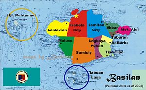
Basilan is subdivided into eleven municipalities and two cities.
Isabela City, (pop. 87, 985) located on the northern shore of Basilan Island facing Zamboanga City, is a component city and capital of the province. Isabela City votes for provincial officials, shares its tax revenues with the province, and continues to be under the jurisdiction of Basilan for the administration of provincially-devolved services and functions. But for the administration of regional services, the city is part of the Zamboanga Peninsula Region despite the rest of Basilan being under the Autonomous Region in Muslim Mindanao. Basilan used to be part of Western Mindanao (the former name of Zamboanga Peninsula), but in a recent plebiscite the residents of some parts of Basilan opted to join ARMM, with the exception of Isabela City (and Lamitan). Called Pasangen by natives, it hosts the Basilan Provincial Capitol and much of the Municipal Offices of its neighboring war-torn municipalities.
Lamitan (pop. 82,075) likewise became a City in 2007, although it remains within the ARMM. It is located on the northeastern coast of Basilan, where most of Basilan's plains are situated. The only remaining opposition stronghold against the Akbar dynasty, Lamitan is experiencing a renewed economic vigor that continues to power the rest of the province's otherwise lackluster growth. A November 18, 2008 decision of the Supreme Court, however, effectively voided the law converting Lamitan to a City after the League of Cities of the Philippines filed a petition earlier in the year. Lamitan has since been reverted to Municipality status pending a motion for reconsideration filed by the affected Municipalities.
The other five (5) original Municipalities are: Maluso (pop. 48,175), located on the island's southwest, this area is facing the bigger island of Sulu and Tawi-Tawi further south, its busiest trading port is located at Port Holland and Maluso Townsite; Lantawan (pop. 28,978) is located on the island's westernmost area, and is mostly an agricultural area for copra and rubber production, its biggest population concentration is located at Tairan, and has no major port; Sumisip (pop. 58,423) is the biggest municipality in terms of land area, and hosts what used to be the biggest rubber plantation (Sime Darby) in the Philippines; Tuburan (pop. 26,498) is located on a peninsula on the extreme eastern part of the island, one of the least developed municipalities and severely devastated by the decades-old armed conflicts plaguing the island; Tipo-Tipo (pop. 26,548), the last among the original municipalities created by Presidential Decree, courtesy of President Ferdinand Marcos, is located on the island's southeast coast, also mostly undeveloped and witness to much of the running gun-battles on the island.
The latest six (6) municipalities are creations of the regional legislature of the ARMM, to wit: Akbar (pop. 21,312), separated from Tuburan municipality, named after a political strongman, the late Congressman Wahab Akbar; Hadji Mohammad Ajul (pop. 26,132), also from Tuburan, named after the first mayor of Tuburan; and, Al-Barka (pop. 26,229) and Ungkaya Pukan (pop. 30,472) municipalities which were separated from Tipo-Tipo, the latter having been named after the grandfather of its present mayor! In 2008, the municipalities of Hadji Muhtamad (pop. 20,292), named after the father of late Cong. Wahab Akbar and separated from Lantawan, and Tabuan-Lasa (pop. 13,384), separated from Sumisip, were similarly created.
All six (6) new municipalities were created without the consent of the Philippine Congress. (Ref. Recent Supreme Court rulings nullified the creation of Shariff Kabunsuan Province, created by the same ARMM Regional Assembly, reverting it to the 1st District of Maguindanao Province)

| City/Municipality | Mayors | No. of Barangays |
Population (2007) |
|---|---|---|---|
| Akbar | Alih A. Salih |
|
|
| Al-Barka | Karam S. Jakilan |
|
|
| Hadji Mohammad Ajul | Talib G. Pawaki |
|
|
| Hadji Muhtamad | Anwar S. Abdulmajid |
|
|
| Isabela City[1] | Cherrylyn Santos-Akbar |
|
|
| Lamitan City | Roderick H. Furigay |
|
|
| Lantawan | Tahira Ismael-Sansawi |
|
|
| Maluso | Sakib A. Salajin, Al Hadj |
|
|
| Sumisip | Haber A. Asarul |
|
|
| Tabuan-Lasa | Muctar Junaid, Al Hadj |
|
|
| Tipo-Tipo | Ingatul Lukman J. Istarul, Al Hadj |
|
|
| Tuburan | Durie S. Kallahal |
|
|
| Ungkaya Pukan | Joel T. Maturan |
|
|
- 1. ^ Administratively part of Zamboanga Peninsula region.
Noted Basilan people
History and politics
- Lakan Ipentun - first recorded Yakan Chieftain of Kumalarang, visited Chinese Emperor Yung Lo, and proclaimed a vassal King ("wang") of the Chinese Empire.
- Datu Bantilan — Tausug chieftain, former Sultan of Sulu, established a Tausug kingdom (Maluso) on the island.
- Datu Kalun (Pedro Cuevas) — Cavite native who married a Yakan princess and subjugated Lamitan.
- Juan S. Alano — Bulacan native, Commonwealth Assemblyman of the Moro Province of Mindanao (1936-1946), first Congressman of the Province of Zamboanga (1946-1949), authored the Charters of the Cities of Zamboanga and Basilan, became the Grand Master of the Freemasons in the Philippines in 1961.
- Nicasio S. Valderroza — Bulacan native, first Mayor of Basilan City (1948-53), also among the first Mayors of Zamboanga (1937-1939), Baguio (1939-1944), and Davao (1944-48) cities.
- Lenora Alano-Rivera - daughter of Juan S. Alano, co-founder of the Girl Scouts of the Philippines, established the first Girl Scout Chapter in Mindanao.
- Leroy S. Brown — The longest-serving Mayor of Basilan City (1954-1975), presided over the rise of Basilan City into first-class status during his term.
- Regino C. Hermosisima, Jr. — Supreme Court Justice, presided over the Aquino-Galman double murder case as a Judge at the Manila RTC. Chairman Emeritus of the Philippine Young Men's Christian Association (YMCA).
- Ulbert Ulama Tugung — Tausug leader, eventually became the first Regional Governor of the defunct Lupong Tagapagpaganap ng Pook (LTP), special administrative arm for the Muslim provinces.
- Asan Camlian — The first Muslim Governor of Basilan, appointed by President Ferdinand Marcos, and subsequently won his seat under Marcos's KBL.
- Louis Walton Alano — OIC Governor of Basilan during the Revolutionary Government of President Corazon C. Aquino (1986-1988), currently the Deputy Governor for Christian Affairs of the Autonomous Region in Muslim Mindanao (ARMM).
- Alvin G. Dans — Variously a Provincial Governor, Congressman, Undersecretary of the DILG, and Philippine Postmaster General.
- Candu I. Muarip — First Yakan politician to be elected to high office, he was appointed Cabinet Secretary for a month during the short-lived Revolutionary Government of Corazon Aquino; he has since been elected Congressman twice, and is a Provincial Board Member
- Perfecto "Toto" Antonio, Jr. - Provincial Board Member, a descendant of Datu Kalun, a National Board Director for the Family Planning Organization of the Philippines for several years, last Christian to be elected to a Provincial office (2004).
- Gerry A. Salapuddin — Former MNLF Commander, schooled in Sorbonne University in Paris, France, became three-term Governor, then three-term Congressman, in the last two of which terms he was elected Deputy Speaker of the House of Representatives.
- Wahab M. Akbar — Former political kingpin and dynast, three-term Governor, elected Congressman in 2007, killed by a bomb blast at the entrance, southwing of the House of Representatives in November 2007.
- Luis R. Biel II - first City Mayor of Isabela, nursed the new City through its first few years, established the Cocowayan Festival in 2002, assassinated by a lone gunman at City Hall on March 3, 2006.
- Roseller Barinaga Long-term Mayor of Dipolog City and three-term Congressman of the 2nd District of Zamboanga del Norte, of Cebuano parentage, a graduate of Basilan City High School, class of 1955.
- Romeo Jalosjos - 3-term Congressman of the first District of Zamboanga del Norte, born in Latuan, Isabela
- Dominador Jalosjos — Mayor of Dapitan City, Zamboanga del Norte, born in Latuan, Isabela City.
- Cynthia Jalosjos-Carreon — Congresswoman of the first District of Zamboanga del Norte, born in Latuan, Isabela City.
- Cesar Jalosjos — Congressman of the third District of Zamboanga del Norte, born in Latuan, Isabela City.
- Theresa M. Alano — Assistant Secretary of the Department of Social Welfare and Development (DSWD).
- Athena Dans — Commissioner, Bureau of Customs (BOC).
- Roberto Reynera — Chief, Presidential Anti-Smuggling Group (PASG).
Entertainment
- Leni Alano-Cabili - Movie Actress and Singer, 1965 FAMAS Best Supporting Actress for her role in "Daigdig ng mga Api", also sung the original recording of the popular Visayan song "Usahay".
- John Estrada — Movie and TV Actor, starred in a number of roles both as leading man and villain, currently on contract with ABSCBN TV2 Manila
- Kaye Abad — Movie and TV Actress, starred in various daytime soaps and primetime dramas, daughter of Basilan Vice Governor Al-Rasheed Sakkalahul
- Sammy Lagmay — Movie and TV Actor, comedic talent featured in a number of TV sitcoms
- Josephine Estrada — Movie Actress from the 1970s
- Cecile Licad — world-renowned Concert Pianist, lived in Basilan for some time with her father Dr. Licad, who helped establish Basilan Hospital (now J. S. Alano Memorial Hospital).
- Alain Echem — Lead vocalist of Frio.
- Jennifer Violet Alano-Colet — 1989 Miss Globe International first runner up
See also
- Legislative district of Zamboanga del Sur
- Wahab Akbar, Governor of Basilan (1998 to 2007)
External links
Official Website: http://www.basilan.gov.ph
Notes
- ↑ Early Mapping of Southeast Asia at Google Book Search
- ↑ "Antique, old, rare and historic Maps & Prints of Southeast Asia". Bergbook.com. Retrieved on 2008-10-05.
- ↑ "OCEAN THERMAL ENERGY POTENTIAL SITES". Department of Energy (Philippines). Retrieved on 2008-10-05.
- ↑ "OCEAN TIDAL ENERGY POTENTIAL SITES". Department of Energy (Philippines). Retrieved on 2008-10-05.
- ↑ "Philippine National Statistical Coordination Board (NSCB)". Nscb.gov.ph. Retrieved on 2008-10-05.
- ↑ "Swish of the Kris - 6. The Seat of Moro Power". Bakbakan.net. Retrieved on 2008-10-05.
- ↑ 7.0 7.1 7.2 Philippine Department of Tourism
- ↑ "NSO Basilan Quickstat". Census.gov.ph. Retrieved on 2008-10-05.
- ↑ "NSCB - Active Stats - PSGC Interactive - Province: BASILAN". Nscb.gov.ph. Retrieved on 2008-10-05.
- ↑ "The Prelature of Isabela de Basilan". Cbcponline.net. Retrieved on 2008-10-05.
- ↑ "All-weather road to unlock Basilan's potential, The Gem Program. April 2, 2007.
- ↑ "Basilan rubber sector eyes rebirth", GMANews.TV (2008-05-28). Retrieved on 2008-10-05.
- ↑ Philippine Information Agency (2008-05-12). "Isabela coconut farmers get incentives from PCA". Press release. Retrieved on 2008-10-05.
- ↑ "Basilan - A Province To Be Watched". WOW Philippines. Retrieved on 2008-11-21.
References
- Philippine House of Representatives Congressional Library
|
||||||||||||||||||||