Basel-Country
| Basel-Landschaft | |||
|
|||
| Capital | Liestal | ||
| Population (2007) | 269,145 (Ranked 10th) | ||
| - Density | 521 /km² | ||
| Area | 518 km² (Ranked 18th) | ||
| Highest point | 1169 m - Hinteri Egg | ||
| Lowest point | 246 m - confluence of Birs river with the Rhine, at Birsfelden | ||
| Joined | 1501 | ||
| Abbreviation | BL | ||
| Languages | German | ||
| Executive | Regierungsrat (5) | ||
| Legislative | Landrat (90) | ||
| Municipalities | 86 municipalities | ||
| Districts | 5 Bezirke | ||
| Website | www.BL.ch | ||
 |
|||

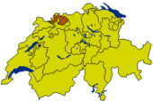
Basel-Country (German: Basel-Landschaft; Swiss German: Basel-Land/Baselbiet) is one of the 26 cantons of Switzerland. The capital is Liestal. It shares borders with the cantons of Basel-Stadt, Solothurn, Jura and Aargau, and with France and the German state of Baden-Württemberg.
Contents |
History
Basel-Landschaft formed together with Basel-Stadt the historic canton Basel until it separated following the uprising of 1833 (Battle of the Hülftenschanz near Frenkendorf).
In Roman times, the area of Basel was a centre of Roman activity. There are well-preserved remains at the site of Augusta Raurica in the canton of Basel-Landschaft. Around 200 there were about 20,000 people living in this city, now part of the much smaller Augst. The remains are on display in an open-air museum. The museum attracts over 140,000 visitors year after year. Many of these visitors are schoolchildren from other parts of Switzerland. The site of Augusta Raurica includes amongst other the best-preserved amphitheatre north of the Alps, or a reconstructed Roman villa.
The lands of the canton Basel-Landschaft are part of the lands acquired by the city of Basel. Until the end of the 16th century, most of the land of Basel-Landschaft belonged to the city of Basel. After Napoleon’s visit in 1798, the country achieved equality with the city. Economically the country was dependent on the city, most probably because of the low level of education in the agricultural areas at the time. The city of Basel remained the cultural and economic centre of both Basel cantons up to these days. Castles and residences owned by Basel merchants dominated much of the landscape in Basel-Country.
After 1830 there were political quarrels and armed conflict in the canton of Basel. Some of it was concerned with the rights of the population in the agricultural areas. This led to the separation of the canton Basel-Landschaft from the city of Basel on 26 August 1833.
Ever since the separation, there has been a movement for re-unification. This movement gained momentum after 1900 when many parts of Basel-Landschaft became industrialized. The two half cantons agreed in principle to re-unify, but in 1969 the people of Basel-Landschaft voted down a referendum in order to keep their independence. It is thought that the closing economic gap between the two cantons was the main reason why the population changed their attitude.
The vote of Basel-Landschaft to keep their independence was not the end of a close relationship between the two Basels. The two half cantons have since signed a number of agreements to co-operate. The contribution of Basel-Landschaft to the University of Basel since 1976 is just one example.
Geography
The canton of Basel-Landschaft lies in the north of Switzerland. The Jura mountain chain traverses the canton. The rivers Ergolz and Birs drain the lands of the canton.
Economy
The main agricultural produce of the canton are fruits, dairy farming and cattle breeding. Important industries include textiles, metals and chemicals.
The canton of Basel-Landschaft is part of the economic centre around Basel that includes parts of France and Germany as well as both cantons of Basel. Since the 1960s there are agreements to strengthen contacts within the so-called Regio Basiliensis. This economic co-operation is often considered as the most intensive within Europe.
From the 17th century until the beginning of the 20th century silk weaving was important in Basel-Landschaft. Factories were established as early as 1850, following the finding of salt in underground deposits, founding industries such as the chemical industry in Schweizerhalle. The chemical industry means that Basel is one of the richer parts of Switzerland.
The chemical industry is not the sole employer in the canton. Small and middle-sized businesses make up about a quarter of the cantonal economy. Many of these, however, are connected to the larger employers.
Regions
The nine municipalities of the Arlesheim district used to belong to the diocese of Basel. In 1792 French troops occupied the district and in 1793 the lands were annexed by France, which explains the linguistic switch of the Family of the House of Basel's name from "von Basel" to "de Bâle", since Arlesheim holds their manor. In 1815 at the Congress of Vienna the district joined Basel.
The district of Laufental has the same history as that of Arlesheim. The important difference is that in 1815 Laufental joined Bern rather than Basel. When the canton of Jura was created in 1979, the district of Laufental became an enclave of the canton of Bern. It was allowed self- determination and in 1980 the people decided to join the canton of Basel-Landschaft. This led to Laufental joining the canton of Basel-Landschaft on 1 January 1994 after a lengthy administrative process.
Politics
Since the decision to remain independent from Basel-Stadt in 1969 there have been a number of requests in the parliament for Basel-Landschaft to become a full canton. In 1988 the canton of Basel-Landschaft had this aim written into its constitution. The aim remains to change the Swiss constitution to recognize the two cantons of Basel as full members.
Demographics
The population is predominantly German speaking. Protestantism is the main religion in the canton. The Swiss Reformed Church and Christian Catholic Church of Switzerland are recognized as state churches. Between 1959 and 1970 the canton was Switzerland's fastest-growing, as the population almost doubled from 108,000 to 205,000. Today, the canton has a population of 269,145 (2007) of which 48,719 (or 18.1%) are foreigners[1].
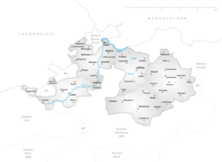
Districts
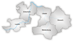
There are 5 Bezirke in Basel-Landschaft:
- Arlesheim (Pop: 145 039) capital: Arlesheim (Pop: 8 944)
- Laufen (Pop: 17 845) capital: Laufen (Pop: 5 039)
- Liestal (Pop: 55 396) capital: Liestal (Pop: 12 817)
- Sissach (Pop: 31 770) capital: Sissach (Pop: 5 569)
- Waldenburg (Pop: 15 045) capital: Waldenburg (Pop: 1 280)
Municipalities
|
District of Arlesheim
District of Laufen
|
District of Liestal
District of Waldenburg
|
District of Sissach
|
See also: Municipalities of Switzerland
See also
- Basellandschaftliche Zeitung, daily newspaper published in Liestal.
External links
- Official Page (German)
- Official Statistics
- Basel-Country in German, French and Italian in the online Historical Dictionary of Switzerland.
References
- ↑ Bundesamt fur Statistik (Federal Department of Statistics) (2008). "Ständige Wohnbevölkerung nach Staatsangehörigkeit, Geschlecht und Kantonen" (Microsoft Excel). Retrieved on November 5, 2008.
|
||||||||||||||||||||||||||||||||||||||