Azores
| Azores Autonomous Region
Região Autónoma dos Açores
|
||||||
|---|---|---|---|---|---|---|
|
||||||
| Motto: "Antes morrer livres que em paz sujeitos"(Portuguese) ("Rather die free than live subjugated") (English) |
||||||
| Anthem: A Portuguesa (national) Hino dos Açores (local) |
||||||
 |
||||||
| Capital | Ponta Delgada1 Angra do Heroísmo2 Horta3 |
|||||
| Largest city | Ponta Delgada | |||||
| Official languages | Portuguese | |||||
| Ethnic groups | Portuguese |
|||||
| Government | Autonomous region | |||||
| - | President | Carlos César | ||||
| Establishment | ||||||
| - | Settled | 1439 | ||||
| - | Autonomy | 1976 | ||||
| Area | ||||||
| - | Total | 2,346 km2 (n/a) 911 sq mi |
||||
| Population | ||||||
| - | 2006 estimate | 243,018 (n/a) | ||||
| - | 2001 census | 241,763 | ||||
| - | Density | 104/km2 (n/a) 266/sq mi |
||||
| Currency | Euro (€)4 (EUR) |
|||||
| Time zone | UTC-1 | |||||
| Internet TLD | .pt | |||||
| Calling code | 351 | |||||
| 1 | Location of the Presidency of the Regional Government (). | |||||
| 2 | Location of the Supreme Court (). | |||||
| 3 | Location of the Legislative Assembly (). | |||||
| 4 | Prior to 2002: Portuguese escudo | |||||


The Azores (Portuguese: Açores pronounced [ɐˈsoɾeʃ] or [ɐˈsoɾʃ]) is a Portuguese archipelago in the Atlantic Ocean, about 1,500 km (950 mi) from Lisbon and about 3,900 km (2,400 mi) from the east coast of North America. The two westernmost Azorean islands (Flores and Corvo) actually lie on the North American plate and are only 1,925 km (1,200 mi) from St. John's in the Canadian province of Newfoundland and Labrador. The Azores' most significant industries are tourism, cattle raising for milk and meat, and fishing.
The nine major Azorean islands and the eight small Formigas extend for more than 600 km (373 mi) and lie in a northwest-southeast direction. The vast extent of the islands defines an immense exclusive economic zone of 1.1 million km². The westernmost point of this area is 3,380 km (2,100 mi) from the North American continent. All of the islands have volcanic origins, although Santa Maria also has some reef contribution. The mountain of Pico on Pico Island, at 2,351 m (7,713 ft) in altitude, is the highest in all of Portugal. The Azores are actually the tops of some of the tallest mountains on the planet, as measured from their base at the bottom of the ocean. The archipelago forms the Autonomous Region of Azores, one of the two autonomous regions of Portugal.

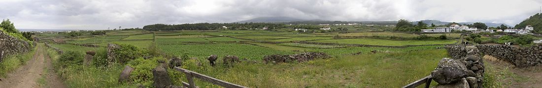
Because these once uninhabited, remote islands were settled sporadically over a span of two centuries, their culture, dialect, cuisine and traditions vary considerably from island to island. Farming and fishing are key industries that support the Azorean economy. These traditional trades give the Azores an unspoiled, historic and authentically European feel that is becoming harder to find in other nearby locations. Visitors find plenty to see and do here, with upscale lodging and restaurants integrating with both the tiny, rural towns and the sometimes wild and lush landscapes that make up the islands. Visitors are still discovering the Azores, and only 240,000 Azoreans live within the archipelago’s 868 square miles.
Although it is commonly said that the archipelago is named after the goshawk (Açor in Portuguese) because it was supposed to be a common bird at the time of discovery, in fact the bird never existed on the islands. Some historians indicate the archaic Portuguese word "azules" (the plural of blue) because of the colour of the islands when seen from afar. Most, however, insist that the name is derived from birds, pointing to a local subspecies of the buzzard (Buteo buteo), as the animal the first explorers erroneously identified as goshawks.
Contents |
History
Discovery

The islands were known in the fourteenth century and parts of them can be seen, for example, in the Atlas Catalan. In 1427, one of the captains sailing for Henry the Navigator, possibly Gonçalo Velho, rediscovered the Azores, but this is not certain. A History of the Azores by Thomas Ashe written in 1813 marks the discovery by Joshua Vander Berg of Bruges in Flanders.[1] Vander Berg was said to have landed there during a storm on his way to Lisbon.[1] Ashe then claims that the Portuguese left to explore the area and claim it for Portugal shortly after.[1]
Colonization
The colonization of the then-unoccupied islands started in 1439 with people mainly from the continental provinces of Algarve and Alentejo. In 1583, Philip II of Spain, as king of Portugal, sent his fleet to clear the Azores of a combined multinational force of adventurers, mercenaries, volunteers and soldiers who were attempting to establish the Azores as a staging post for a rival pretender to the Portuguese throne. Following the success of his fleet at the Battle of Ponta Delgada, the captured enemy were hanged from yardarms, as they were considered pirates by Philip II. (This was added to the "Black Legend" by his enemies.) The Azores were the second-to-last part of the Portuguese empire to resist Philip's reign over Portugal (Macau being the last) and were returned to Portuguese control with the end of the Iberian Union, not by the professional military, who were used in the Restoration War in the mainland, but by local people attacking a fortified Castilian garrison (guarnición).

1820 Portuguese civil war
The 1820 civil war in Portugal had strong repercussions in the Azores. In 1829, in Vila da Praia, the liberals won over the absolutists, making Terceira Island the main headquarters of the new Portuguese regime and also where the Council of Regency (Conselho de Regência) of Mary II of Portugal was established.
Beginning in 1868, Portugal issued its stamps overprinted with "AÇORES" for use in the islands. Between 1892 and 1906, it also issued separate stamps for the three administrative districts of the time.
From 1836 to 1976, the archipelago was divided into three districts, equivalent (except in area) to those in the Portuguese mainland. The division was arbitrary, and did not follow the natural island groups, rather reflecting the location of each district capital on the three main cities (none of which were on the western group).
- Angra do Heroísmo consisted of Terceira, São Jorge, and Graciosa, with the capital at Angra do Heroísmo on Terceira.
- Horta consisted of Pico, Faial, Flores, and Corvo, with the capital at Horta on Faial.
- Ponta Delgada consisted of São Miguel and Santa Maria, with the capital at Ponta Delgada on São Miguel.

In 1943, during the Second World War, The Portuguese dictator, António de Oliveira Salazar, leased bases in the Azores to the British, despite his previous collaboration with Germany. [2] This was a key turning point in the Battle of the Atlantic, allowing the Allies to provide aerial coverage in the middle of the Atlantic. This helped them to hunt U-boats and protect convoys.
In 1944, American forces constructed a small and short-lived air base on the island of Santa Maria. In 1945, a new base was constructed on the island of Terceira and is currently known as Lajes Field. This base is in an area called Lajes, a broad, flat sea terrace that had been a farm. Lajes Field is a plateau rising out of the sea on the northeast corner of the island. This Air Force base is a joint American and Portuguese venture. Lajes Field continues to support United States and Portuguese military operations. During the Cold War, the United States Navy P-3 Orion anti-submarine squadrons patrolled the North Atlantic for Soviet submarines and surface spy vessels. Since its inception, Lajes Field has been used for refuelling aircraft bound for Europe, and more recently, the Middle East. The United States Army operates a small fleet of military ships in the harbour of Praia da Vitória, three kilometres (2 mi) southeast of Lajes Field. The airfield also has a small commercial terminal handling scheduled and chartered passenger flights from other islands in the archipelago, Europe, and North America.
In 1976, the Azores became the Autonomous Region of the Azores (Região Autónoma dos Açores), one of the Autonomous regions of Portugal, and the Azorean districts were suppressed.
Politics
Since becoming a Portuguese Autonomous Region, the executive section of the local authority has been located in Ponta Delgada, the legislative in Horta and the judicial in Angra do Heroísmo. The President of the Regional Government is now Carlos César.
Azorean politics are dominated by the two largest Portuguese political parties—PSD and PS, the latter holding a majority in the Regional Legislative Assembly. The CDS/PP, BE, CDU and PPM are also represented in the local parliament. Even though the PS dominates the administrative scene, the PSD is usually more popular in city and town council elections.
|
|||||||||||
Municipalities
The Azores are divided into nineteen municipalities (concelhos); each municipality is further divided into parishes (freguesias). The Azores have a total of 156 parishes.
The Western Group
- Flores
- Lajes das Flores and Santa Cruz das Flores
- Corvo
- Corvo
The Central Group
- Terceira
- Angra do Heroísmo and Vila da Praia da Vitória
- Graciosa
- Santa Cruz da Graciosa
- São Jorge
- Calheta and Velas
- Pico
- Lajes do Pico, Madalena and São Roque do Pico
- Faial
- Horta
The Eastern Group
- Santa Maria
- Vila do Porto
- São Miguel
- Lagoa, Nordeste, Ponta Delgada, Povoação, Ribeira Grande, and Vila Franca do Campo.
Cities
There are five cities in the Azores: Ponta Delgada and Ribeira Grande on São Miguel Island; Angra do Heroísmo and Praia da Vitória on the island of Terceira, and Horta on the island of Faial. Three of these Ponta Delgada, Angra and Horta are considered capital cities in the regional government, homes to the President (Ponta Delgada), the Judiciary (Angra) and the Regional Assembly (Horta).
Geography

| Island | Area | |
|---|---|---|
| São Miguel Island | 759 km2 | 293 sq mi |
| Pico Island | 446 km2 | 172 sq mi |
| Terceira Island | 403 km2 | 156 sq mi |
| São Jorge Island | 246 km2 | 95 sq mi |
| Faial Island | 173 km2 | 67 sq mi |
| Flores Island | 143 km2 | 55 sq mi |
| Santa Maria Island | 97 km2 | 37 sq mi |
| Graciosa Island | 62 km2 | 24 sq mi |
| Corvo Island | 17 km2 | 7 sq mi |
The archipelago is spread out in the area of the parallel that passes between through Lisbon (39° 43' / 39° 55' N) and 37° N, giving it a tepid oceanic subtropical climate, with mild annual oscillation. The average annual rainfall increases from east to west and ranges from 700 to 1600 annual millimetres (27.6–63 in) on average, reaching 6,300 millimetres (250 in) in Mount Pico (the highest Portuguese mountain at 2,351 m/7,713 ft). The Azores High, an area of high atmospheric pressure, is named after the islands. The Formigas (the Portuguese word for "ants") islands (also known as Dollabarat Reefs) have rich maritime fauna, including exotic species such as the black coral and manta rays, sharks, and sea turtles. The archipelago lies in the Palearctic ecozone, forming a unique biome that includes the macaronesian subtropical laurissilva, with many endemic species of plants.
The nine islands have a total area of 2,346 km2 (906 sq mi). Their individual areas vary between São Miguel's 759 km2 (293 sq mi) and Corvo's 17 km2 (7 sq mi). Three islands (São Miguel, Pico and Terceira) are bigger in size than Malta (composed of three different islands), São Miguel Island alone being twice as big.
The nine islands are divided into three groups:
- The Eastern Group (Grupo Oriental) of São Miguel, Santa Maria and Formigas Islets
- The Central Group (Grupo Central) of Terceira, Graciosa, São Jorge, Pico and Faial
- The Western Group (Grupo Ocidental) of Flores and Corvo.
Geology
The islands are located atop an active triple junction between three large tectonic plates: the North American Plate, the Eurasian Plate and the African Plate. Volcanism associated with the formation of the islands arises from the fact that the Azores Triple Junction involves rifting, a process whereby the crust is spreading along three ridge legs radiating out from the triple junction. The volcanism is also related to the Azores hotspot. The islands began forming during the Tertiary period. Pico, a volcano that stands 2,351 metres (7,713 ft) high on the island of the same name, has the highest altitude in the Azores and all of Portugal.
The last volcano to erupt was the Capelinhos Volcano (Vulcão dos Capelinhos) in 1957, in the western part of Faial Island, increasing the size of the island by 2.4km, but it's estimated that the great part of it will be washed away in next 20 years. Santa Maria Island is the oldest Azorean island, formed 4.8 million years ago, and is the only island in the Azores with an abundance of sediments where marine fossils have been discovered.
The Gruta das Torres, Algar do Carvão, Gruta do Natal, Gruta das Cinco Ribeiras are some of the many caves of the Azores.
Demographics
On 31 December 2002, the Azores' population was 238,767 at a density of 106 inhabitants per square kilometer (274.5/sq mi).
| Island | Population (2002) | Main city/town |
Municipalities | |
|---|---|---|---|---|
| (% of total) | ||||
| São Miguel Island | 130,154 | 54.50 | Ponta Delgada | 6 |
| Terceira Island | 54,996 | 23.00 | Angra do Heroísmo | 2 |
| Faial Island | 14,934 | 6.25 | Horta | 1 |
| Pico Island | 14,579 | 6.11 | Madalena | 3 |
| São Jorge Island | 9,522 | 3.99 | Velas | 2 |
| Santa Maria Island | 5,490 | 2.30 | Vila do Porto | 1 |
| Graciosa Island | 4,708 | 1.97 | Santa Cruz da Graciosa | 1 |
| Flores Island | 3,949 | 1.65 | Santa Cruz das Flores | 2 |
| Corvo Island | 435 | 0.18 | Vila do Corvo | 1 |
| Total | 238,767 | Total | 19 | |
Population
The vast majority of the inhabitants of the Azores are Portuguese, descendants of 15th century immigrants from Algarve (Southern Portugal) and from the Minho (Northern Portugal), with a minor Dutch admixture (particularly from Flanders). The Azores, along with virtually all other Portuguese islands, also had tremendous sugarcane plantations in which the Portuguese brought African slaves, leading to an African influence and mixture. In addition, the Azores were once territory of Spain, so there is a considerable Spanish influence.
Since the 17th century, many of them have emigrated, mainly to Brazil, the United States and Canada.[3] Southeastern Massachusetts, especially the cities of New Bedford and Fall River, was a primary destination for Azorean emigrants. [4]
Traditional festivals from May through September Holy Ghost Festivals, or Espírito Santo Festivals, are very important to the Azorean people. The festivals are rooted in medieval traditions and typically held on all the islands from May to September, including lively parades and large feasts. As part of the tradition, soup and bread are handed out to revelers during these events. On Terceira and other islands, decorative houses called Imperios are the staging points for the feeding of the masses.
May marks The Festival of Senhor Santo Cristo dos Milagres (Lord Holy Christ of Miracles) in Ponta Delgada on the island of São Miguel. The largest religious event in the Azores is the Festa do Senhor Santo Cristo takes place on the 5th Sunday after Easter. Pilgrims from all over the world unite to parade behind the image of Christ on a three-hour procession along the flower decorated streets of the city. The Sanjoaninas Festivities in Angra do Heroísmo in Terceira are held in June honoring S. Antonio, S. Pedro and St. João, in a large religious celebration. The traditional bullfights in the bullring are ongoing, as is the running of bulls in the streets. The festival of Nossa Senhora de Lourdes, (Our Lady of Lourdes), patron saint to the Whalers, begins in Lajes on Pico on the last Sunday the August and runs through the week - Whalers Week. It is marked by social and cultural events connected to the tradition of whale hunting. The Festa das Vindimas, (Wine Harvest Festival), takes place during the first week of September and is a century old custom ways by the people of Pico.
In Corvo the people celebrate their patron saints Nossa Senhora dos Milagres, (Our Lady of Miracles), on August 15th every year in addition to the festivals of the Divine Holy Spirit. The Festival da Maré de Agosto (August Sea Festival), takes place every year beginning on the 15th of August in Praia Formosa on Santa Maria. And, the Semana do Mar (Sea Week), dedicated almost exclusively to water sports, takes place in August in the city of Horta, on Faial. In the Azores, Mardi Gras is known as “Carnaval”, a four-day celebration starting in February. Parades and pageants are heart of the Carnaval festivities. There is lively music, colorful costumes, hand-made masks, and floats.
See also
- Canary Islands
- Cape Verde
- Madeira
- Macaronesia
- Postage stamps and postal history of the Azores
References
- ↑ 1.0 1.1 1.2 Ashe, Thomas (1813). History of the Azores, or. Western islands. Oxford University.
- ↑ The Role of Portugal - co-opting Nazi Gold, Jonathan Petropoulos, Dimensions, , Vol 11, No 1, 1997
- ↑ Azores Islands
- ↑ http://www.ojornal.com/site/news.cfm?newsid=20087125&BRD=2677&PAG=461&dept_id=543384&rfi=6
External links
- Wikimedia Atlas of the Azores
- Azores.gov.pt Azores Regional Government
- Arquivo dos Açores - Universidade dos Açores
- Wikitravel
- Azores Tourism Board
- History from an American Military source
- Azores Weathercams (Projectos Climaat e Climarcost)
- Azores (Portugal), coat of arms Coat of arms eps, svg
- SATA Airlines
- Birding Azores
|
||||||||||||||||||||||
|
|
||||||||||||||||||||||||||||||||||||||||||||||||||
|---|---|---|---|---|---|---|---|---|---|---|---|---|---|---|---|---|---|---|---|---|---|---|---|---|---|---|---|---|---|---|---|---|---|---|---|---|---|---|---|---|---|---|---|---|---|---|---|---|---|---|
|
||||||||||||||||||||||||||||||||||||||||||||||||||
|
|
|||||||||||||||||||||
|---|---|---|---|---|---|---|---|---|---|---|---|---|---|---|---|---|---|---|---|---|---|
|
|||||||||||||||||||||
|
|||||||||||||||||