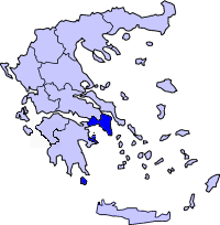
Attica
| Attica Periphery Περιφέρεια Αττικής |
|
|---|---|
 |
|
| Country: | |
| Capital: | Athens |
| Prefectures: | Athens East Attica Piraeus West Attica |
| Population: | 3,841,408
(2005) |
| Area: | 3,808 km² (1,470 sq.mi.) |
| Density: | 1,009 /km² (2,613 /sq.mi.) |
| Website: | www.attiki.gov.gr |
Attica (Greek: Αττική, Attikí; IPA: [atiˈkʲi]) is a periphery (subdivision) in Greece, containing Athens, the capital of Greece. Attica is subdivided into the prefectures of Athens, Piraeus, East Attica and West Attica.
Contents |
Overview
Located in the south of the country, Attica covers about 3,808 square kilometers. In addition to Athens, it contains within its area the cities of Peiraeus, Eleusis, Megara, Laurium, and Marathon, as well as a small part of the Peloponnese peninsula and the islands of Salamis, Aegina, Poros, Hydra, Spetses, Kythira, and Antikythera. About 3,750,000 people live in the periphery, of which more than 95% are inhabitants of the Athens metropolitan area.
Athens was originally the capital of Central Greece.
Geography

Attica is a peninsula jutting into the Aegean Sea. It is naturally divided to the north from Boeotia by the 10 mi (16 km) long Kithairon mountain range. Mountains separate the peninsula into the plains of Pedia, Mesogeia, and Thriasia. The mountains include Hymettus, the eastern portion of Geraneia, Parnitha, Aigaleo and the Penteli mountains. To the north it is bordered by the Boeotian plain and to the west it is bordered by Corinth. The Saronic Gulf lies to the south and the island of Euboea lies off the north coast. Athens' first and only large reservoir, Lake Marathon, is about 42 km (26 mi) northeast and is called the Marathon Dam, which first opened in the 1920s. Since that time, it has been Attica's largest lake. Forests cover the area around Parnitha, around Hymettus and into the northeast and the north in the hills and the mountains, except for the mountaintops, but the mountains to the west and the south are grassy, barren or forested.
The Cephisus River is the longest river, and Parnetha or Parnitha is the tallest mountain in Attica. The prefecture also has parklands in the Hymettus, Penteli and the Parnitha mountains and the southern part of the peninsula.
According to Plato, Attica's ancient boundaries were fixed by the Isthmus, and in the direction of the continent they extended as far as the heights of Cithaeron and Parnes. The boundary line came down in the direction of the sea, having the district of Oropus on the right, and with the river Asopus as the limit on the left.
History
Antiquity
The ancient Athenians used to boast about them being "autochtones", i.e. that they did not move to Attica from another place. The truth is that Attica was inhabited from the Neolithic period by the Ionians, one of the first Indo-European tribes.[1] The Ionians were divided into four tribes and lived in autonomous agricultural societies. The main places where prehistoric remains were found are Marathon, Rafina, Nea Makri, Brauron, Thorikos, Agios Kosmas, Eleusis, Menidi, Markopoulo, Spata, Aphidnae and Athens. All of these settlements flourished mainly during the Mycenaean period[2]. According to tradition, Attica was composed of twelve small communities during the reign of king Cecrops, and these were later incorporated into a single Athenian state during the reign of the mythical king of Athens, Theseus. The truth is that the communities were progressively incorporated into a single Athenian state probably during the 8th and 7th century BC[3]. Athens soon became the capital in spite of the independence of the communities. Until the 6th century BC, aristocratic families lived an independent life in the suburbs. Only after Peisistratus tyranny and the reforms implemented by Cleisthenes did the local communities lose their independence and succumb to the central government in Athens. As a result of these reforms, Attica was divided into approximately a hundred municipalities "dēmoi" (δήμοι) and into three big large sectors: the city (άστυ), which comprised the areas of central Athens, Ymittos, Aegaleo and the foot of Mount Parnes, the coast (παράλια), that included the areas from Eleusis to Cape Sounion and the area around the city (εσωτερικό-μεσογαία), inhabited by people living on the north of Mount Parnitha, Pentelicum and the area surrounding the mountain of Ymittos. The "dēmoi" were in their turn divided into "trittyes" (τριττύες). A “trittya” from each of the above mentioned sectors constituted a tribe. Consequently, Attica consisted of ten tribes.
Fortresses
During the Classical period, Athens was fortified to the north by the fortress of Eleutherae, which is preserved in an almost perfect condition. Other fortresses are those of Oenoe, Decelea and Aphidnae. On the coast, Athens was fortified by the walls at Rhamnus, Thoricus, Sounion, Anavyssos, Piraeus and Eleusis, in order to protect the mines at Laurium[4].
Places of worship
Even though archaeological remains are found in nearly the whole area of Attica, the most important of them all are the remains found in Eleusis. The worship of the goddess Demeter and Cora, deriving from the Mycenaean period, continued until the late years of antiquity. Many other types of worship can be traced back to the Prehistoric years. For example, the worship of Pan and the Nymphs was common in many areas of Attica such as Marathon, Parnes and Ymittos. The god of wine, Dionysus, was worshipped mainly in the area of Icaria, nowadays the suburb of Dionysus. Iphigeneia and Artemis were worshipped in Brauron, Artemis in Rafina, Athena on Sounion, Aphrodite on Iera Odos and Apollo in Daphne.[5]
Byzantine period
After the period of antiquity, Attica came under Roman, Byzantine, Venetian and Ottoman rule. During the Byzantine period, Athens was invaded by the Goths under the commands of Alaric in 396 AD. Attica's population diminished in comparison to the neighboring area of Boeotia. The sites of historical interest date back to the 11th and 12th century, when Attica was under the rule of the Franks. The great monastery of Dafni that was built under Justinian's rule is an isolated case that does not signify a widespread development of Attica during the Byzantine period. On the other hand, the buildings built during the 11th and 12th century show a greater flourishment, that continues during the rule of the Franks, that did not impose a strict rule. During the Ottoman rule, Athens enjoys some rights. On the contrary, that is not the case for the villages of Attica. Great areas were possessed by the Turks, who terrorized the population with the help of spachides (σπάχηδες). The monasteries of Attica play a crucial role in preserving the Greek element of the villages. In spite of its conquerors, Attica managed to maintain its traditions. This fact is proven by the preservation of the ancient toponyms such as Oropos, Dionysus, Eleusis and Marathon. During the Greek War of Independence, the peasants of Attica were the first to revolt (April 1821) and they occupied Athens and seized the Acropolis, that is handed over to the Greeks in June, 1822.[6]
Attica after 1829
Attica has, since 1829, belonged to the independent Greek state. Its inhabitants were, among others, mostly Arvanites, an Albanian-speaking people.
From 1834, Athens was refounded and made the new Greek capital (moved from Nauplia in Argolis), and Greek-speaking people gradually began to repopulate Attica. The most dramatic surge came with Greek refugees from Anatolia following the population exchanges between Greece and Turkey under the Treaty of Lausanne. Today, much of Attica is occupied by the Athens metropolitan area.
The modern Greek periphery of Attica includes classic Attica as well as the Saronic Islands, a small part of the Peloponnese around Troezen, and the Ionian Island of Cythera.
Climate

The climate is typically Mediterranean, with hot dry summers and generally low rainfall totals. Annual precipitation varies from 370 mm to over 1000 mm. Winters are cool and generally mild in the low-lying areas adjacent to the sea, but are harsher in the mountains. It is often the case that snowfalls cause disruption in areas of Attica, although these disruptions are rarely widespread for the whole of the region of Athens, with the latest cases being in January 2002, February 2004 and January 2006. The absolute minimum temperature of the region is -10.4°C and was recorded at Votanikos, Athens, while the highest temperature was recorded at Tatoi (airport) and was +48.7°C. Forest fires and flash floods are common.
Major communities
|
|
Transportation
Roads and Highways
The area is connected by roads and highways:
- Greek National Road 1 (motorway)
- Greek National Road 3 (old highway of Athens-Thessaloniki)
- Greek National Road 8 (old highway linking Patras, the Peloponnese and Athens)
- Greek National Road 8A (motorway)
- Greek National Road 79
- Greek National Road 83 (Marathonos Avenue)
- Greek National Road 89
- Greek National Road 91
- Attiki Odos, number 6 (privately owned motorway), gradually opened from 2001 to 2004
- Hymettus Ring (number 64), opened in 2004
- Egaleo Ring (number 65), opened in 2004, still under construction in its southern part.
Ferry lines
Numerous ferry lines, both normal ferries and the "flying dolphins" (fast sea vessels), connect the port of Piraeus with the islands of the periphery.
Other
- Athens Mass Transit System
- Athens Metro
- Attiki station
- Proastiakos
- Transit System (Attica)
Sports
Football/soccer teams
Premier and second divisions A & B' Ethniki (2006-07)
- AEK - Athens
- Chaidari - Chaidari Athens
- Chalkidona - Chalkidona
- Egaleo FC (or Egaleo) - Aegaleo Athens
- Ethnikos Asteras - Kesariani Athens
- Ethnikos Piraeus - Piraeus Athens
- Ilisiakos - Zografou Athens
- Ionikos - Nikaia, founded in 1965
- Kallithea - Kallithea (Athens), founded in 1966 --
- Olympiacos (Olympiakos Syndesmos Filathlon Pireos, OSFP) - Piraeus
- Panathinaikos - Athens
- Panionios NFC - Nea Smyrni (Athens)
- Proodeutiki - Nikaia (Athens)
- Thrasivoulos - Fyli Athens
Third division
- Acharnaikos - Acharnes (Menidi)
- Agios Demetrios - Athens
- Aias Salamina - Salamina
- Apollon - Athens
- Ilioupoli GS
- Koropi AO
- Vyzas - Megara
Junior division/unassorted
- Aittitos - Spata
- Aris Petroupoli - Petroupoli
- Aris Vari FC - Vari
- Artemis FC - Artemis (Loutsa)
- Aspropyrgos
- Gkyziakos - Gkyzi
- Kouvaras AC - Kouvaras
- Olympiakos Papagou - Papagou
- Panelefsiniakos - Eleusis
All sports
- Ampelokipoi AC - Athens (in the area of Ampelokipoi), fourth division
- Ethnikos GS - Athens, fourth division
- Fokianos Athinon - Athens, fourth division
Mini Football
- Mini soccer fields - Online bookings
- Mini soccer fields and football academies
- Mini Football/soccer fields
Hospitals
- Agios Panteleimonas Hospital - Nikaia
- Eleusis Hospital - Eleusis
- Laikon Hospital - Zografou
- Metropolitan Hospital - Athens
- Tzaneio Hospital - Piraeus
- Asklipio - Voula
- Eginition Hospital - Athens
- Evgenidion Hospital - Athens
- Evangelismos Hospital - Athens
Municipalities and communities
- List of municipalities and communities in Attica
- List of settlements in Attica
Provinces
- Province of Attica - Athens
- Province of Kythera
- Province of Megara (Megaris) - Megara
- Province of Salamis - Salamis, now part of Piraeus
The former provinces in italics no longer exist.
References
- ↑ Ancient History until 30 BC (Ιστορία των αρχαίων χρόνων ως το 30 πΧ), L.Tsaktsiras, M. Tiverios, schoolbook for A' Gymnasiou, 13th edition, Athens, 1994, p. 115
- ↑ diocles.civil.duth.gr/links/home/database/periferiaprotevousis/pr05hi.pdf
- ↑ Ancient History until 30 BC (Ιστορία των αρχαίων χρόνων ως το 30 πΧ), L.Tsaktsiras, M. Tiverios, schoolbook for A' Gymnasiou, 13th edition, Athens, 1994, p. 115
- ↑ diocles.civil.duth.gr/links/home/database/periferiaprotevousis/pr05hi.pdf
- ↑ diocles.civil.duth.gr/links/home/database/periferiaprotevousis/pr05hi.pdf
- ↑ diocles.civil.duth.gr/links/home/database/periferiaprotevousis/pr05hi.pdf
See also
- List of traditional Greek place names
External links
|
|||||||
|
|||||||