Ashton-under-Lyne
| Ashton-under-Lyne | |
|
|
|
 Ashton-under-Lyne shown within Greater Manchester |
|
| Population | 43,236 (2001 Census) |
|---|---|
| - Density | 12,374 per mi² (4,777 per km²) |
| OS grid reference | |
| - London | 160 mi (257 km) SSE |
| Metropolitan borough | Tameside |
| Metropolitan county | Greater Manchester |
| Region | North West |
| Constituent country | England |
| Sovereign state | United Kingdom |
| Post town | ASHTON-UNDER-LYNE |
| Postcode district | OL6, OL7 |
| Dialling code | 0161 |
| Police | Greater Manchester |
| Fire | Greater Manchester |
| Ambulance | North West |
| European Parliament | North West England |
| UK Parliament | Ashton-under-Lyne |
| List of places: UK • England • Greater Manchester | |
Ashton-under-Lyne (pop. 43,200) is a market town in the Metropolitan Borough of Tameside, Greater Manchester, England.[1] It lies on the north bank of the River Tame, on undulating land at the foothills of the Pennines. Ashton (as it is often shortened to) is 3.8 miles (6.1 km) south-southeast of Oldham, 6.1 miles (9.8 km) north-northeast of Stockport, and 6.2 miles (10.0 km) east of the city of Manchester.
Historically a part of Lancashire, Ashton-under-Lyne and its surrounding area have provided evidence of Stone Age, Romano-British and Viking activity. The "Ashton" part of its name probably dates from the Anglo-Saxons, and derives from Old English meaning "settlement by ash trees", while the "under-Lyne" element is less clear,[2] possibly deriving from the British lemo meaning elm or else from Ashton's proximity to the Pennines.[3] During the Middle Ages, Ashton-under-Lyne formed a parish and township centred on Ashton Old Hall which was held by the de Asshetons, the Lords of the Manor. Granted a Royal Charter in 1414, the manor spanned a broad rural area comprising marshland, moorland and a variety of villages and hamlets.
Until the introduction of the cotton trade in 1769, Ashton was "bare, wet, and almost worthless".[3] The factory system, and textile manufacture during the Industrial Revolution facilitated a process of unplanned urbanisation in the area, and by the mid-19th century Ashton had emerged as an important mill town at a convergence of newly constructed canals and railways. Ashton-under-Lyne's transport network allowed for an economic boom in cotton spinning, weaving, and coal mining, so much so that it was granted borough status in 1847.
Imports of cheaper foreign goods led to the decline of Ashton's heavy industries during the mid-20th century. However, the town itself has continued to thrive as a centre of commerce, and is "considered the hub of Tameside, providing the perfect setting for the town hall, council offices and 19th-century market hall".[4] Ashton Market is one of the largest outdoor markets in the United Kingdom. The 13,000-square-metre (140,000 sq ft), two-floored Ashton Arcades shopping centre opened in 1995, and in 2006 IKEA opened the then tallest store in the country.
Contents |
History
Prehistoric activity in the area centres around Ashton Moss, a peat bog covering 107 hectares (260 acres).[5] A single Mesolithic flint was found in Ashton Moss, which is the only one of 22 Mesolithic sites in Tameside not located in the hilly uplands in the north east of the borough.[6] A collection of nine Neolithic flints were also unearthed from Ashton Moss.[7] There was further activity in or around the bog in the Romano-British period. In around 1911 an adult male skull was found in the moss. A precise date for the skull cannot be ascertained, however it was probably linked to the cult of the head which was responsible for the Lindow Man bog body.[8]
The eastern terminus of the early medieval linear earthwork Nico Ditch is in Ashton Moss (grid reference SJ909980); it was probably used as an administrative boundary and dates from the 8th or 9th centuries. Legend claims it was built in a single night in 869–870 as a defence against Viking invaders.[9][10] Further evidence of Dark Age activity in the area comes from the name of the town. The "Ashton" part of its name probably derives from the Anglo-Saxon meaning "settlement by ash trees",[11][12] while the "under-Lyne" element is less clear, possibly deriving from the British lemo meaning elm or else to Ashton's proximity to the Pennines.[3] This means that Ashton probably became a settlement sometime after the Romans left Britain.[13] An early form of the town's name, which included a burh element, indicates that in the 11th century, Ashton-under-Lyne and Bury were two of the most important towns in Lancashire.[14] The "under-Lyne" facet of the name was not widely used until the mid-19th century when it became useful as a means of distinguishing the town from other places named Ashton.[15]
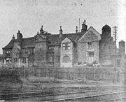
Ashton was not mentioned by name in the Domesday Survey of 1086, perhaps because only a partial survey of the area was taken.[16][17] It is thought that St Michael's Church, mentioned in the entry for the ancient parish of Manchester in the Domesday Survey, was in Ashton. The town itself was first mentioned in the 12th century when the manor was part of the barony of Manchester.[16] By the late 12th century, a family who adopted the name Assheton held the manor on behalf of the Barons of Manchester.[18] Ashton Old Hall was a manor house and the seat of the Assheton family, the administrative centre of the manor.[19] With three wings, the hall was "one of the finest great houses in the North West" of the 14th century and antiquarian John Aikin described it as "a building of great antiquity".[19] It has been recognised as important for being one of the few great houses in south-east Lancashire and possibly one of the few halls influenced by French design in the country.[19] In 1414, Ashton was granted a Royal Charter allowing it to hold a fair twice a year and a market on every Monday,[20][21] making the settlement a market town.[22]
According to popular tradition Sir Ralph de Assheton, who was Lord of the Manor in the mid-14th century and known as the Black Knight, was an unpopular and cruel lord. After his death, his unpopularity led the locals to parade an effigy of him around the town each Easter Monday and collect money.[23] Afterwards the effigy was hung up and shot before being set on fire. It was then torn apart and thrown into the crowd.[24] On this day, shops in the town would remain closed; the tradition continued into the 1830s.[25] The first recorded occurrence of this is in 1795, although the tradition may be even older.[26]
The manor of Ashton remained in the hands of the Ashton family until 1514 when the line ended; it was later acquired by Sir George Booth and descended with the Booth family until 1758 when the Earls of Stamford inherited it through marriage. The earls then held the manor until the 19th century.[27] The lords' consistent absence from the manor is said to have been the stimulus for Ashton's growth of a large scale domestic-based textile industry in the 17th century.[28] Pre-industrial Ashton-under-Lyne was centred around four roads: Town Street, Crickets Lane, Old Street, and Cowhill Lane. In the late-18th and early-19th centuries, the town was re-planned, with a grid pattern of roads. This meant that very little remains of the previous town.[22] In 1730 a workhouse was established which consisted of a house and two cottages; it later came to be used as a hospital.[29] The Ashton Canal was constructed in the 1790s to transport coal from the area to Manchester, with a branches to the coal pits at Fairbottom.[30]


The weaving of fustian and woollens in the domestic system has a long history in the town, dating back to at least the Early Modern period. Accounts dated 1626 highlight that Humphrey Chetham had dealings with cloth-makers in Ashton-under-Lyne.[31] However, the introduction of the factory system following the Industrial Revolution changed the town in the 19th century, from a market town to a mill town. Having previously been one of the two main towns in the Tame Valley, Ashton-under-Lyne became one of the "most famous mill towns in the North West".[32] From 1773 to 1905, 75 cotton mills were established in the town. On his tour of northern England in 1849, Scottish publisher Angus Reach said:
In Ashton, too, there lingers on a handful of miserable old men, the remnants of the cotton hand-loom weavers. No young persons think of pursuing such an occupation. The few who practice it were too old and confirmed in old habits, when the power-loom was introduced, to be able to learn a new way of making their bread.[33]
—Angus Reach, Morning Chronicle, 1849
The cotton industry in the area grew rapidly from the start of the 19th century to 1860 when the Lancashire Cotton Famine of 1861–1865 curtailed growth.[34] The growth of the textile industry in the town led to the construction of estates specifically for workers. For example, workers' housing in Park Bridge, on the border between Ashton and Oldham, was created in the 1820s.[35] The iron works were founded in 1786 and were some of the earliest in the north west.[36] The Oxford Mills settlement was founded in 1845 by local industrialist and mill-owner Hugh Mason[37] who saw it as a model industrial community.[15] He estimated that establishing the settlement cost him around £10,000 and would require a further £1,000 a year to maintain (today about £600,000 and £60,000 respectively) and that the annual death rate there was significantly lower than in the rest of the town.[38][39]
In 1837 the Ashton Poor Law Union was established and covered most of what is now Tameside. A new workhouse was built in 1850 which provided housing for 500 people. It later became part of Tameside General Hospital.[29] Construction on the Sheffield, Ashton-under-Lyne and Manchester Railway (SA&MR) began in 1837 to provide passenger transport between Manchester and Sheffield. Although a nine-arch viaduct in Ashton collapsed in April 1845, the line was fully opened on 22 December 1845. The SA&MR was amalgamated with the Sheffield and Lincolnshire Junction Railway, the Great Grimsby & Sheffield Railway, and the Grimsby Docks Company in 1847 to form the Manchester, Sheffield and Lincolnshire Railway (MS&LR).[40] In 1890, Ashton Old Hall was bought and demolished by the MS&LR to make way for the construction of new sidings.[19]
In the late 19th century, public buildings such as the market hall, the town hall, the public library, and public baths were built.[37] The baths built in 1870–1871 were funded by donation from Hugh Mason.[41] The Ashton-under-Lyne Improvement Act was passed in 1886 which gave the borough influence over housing and allowed the imposition of minimum standards such as having drainage.[42] Coal mining was a secondary industry in the town compared to the textile industry, but in 1882 the Ashton Moss Colliery had the deepest mine shaft in the world at 870 metres (2,900 ft).[43] Ashton's textile industry remained constant between 1865 and the 1920s. Although some mills closed or merged, the number of spindles in use increased.[34][44] With the collapse of the overseas market in the 1920s, the town's cotton industry went into decline, and by the 1930s most of the firms and mills in the area had closed.[34]
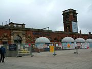
Ashton became a part of the newly formed metropolitan borough of Tameside in 1974.[45] In May 2004, the Victorian market hall was ravaged by a massive fire and a temporary building called "The Phoenix Market Hall" was built on Old Cross Street on the opposite side of the old market hall.[46] Plans are now under way to rebuild the market hall and outdoor market with the work scheduled for completion by November 2008.[47]
Governance

Lying within the historic county boundaries of Lancashire since the early 12th century, Ashton-under-Lyne anciently constituted a "single parish-township", but was divided into four divisions (sometimes each styled townships): Ashton Town, Audenshaw, Knott Lanes and Hartshead.[1][48][49] Ashton Town had been granted a Royal Charter in 1414, making it a market town. All four divisions lay within the hundred of Salford.[1]
In 1827 police commissioners were established for Ashton Town, with the intention of bringing about the social and economic improvement of the area.[1] In 1847 this area was incorporated under the Municipal Corporations Act 1835, as a municipal borough with the name "Ashton-under-Lyne", giving it borough status in the United Kingdom.[1][50] When the administrative county of Lancashire was created by the Local Government Act 1888, the borough fell under the newly created Lancashire County Council.[1] The borough's boundaries changed during the late 19th century, by small exchanges of land with the neighbouring districts of Oldham, Mossley, Dukinfield and Stalybridge.[1] In the early 19th century, the Borough of Ashton-under-Lyne grew; Hurst Urban District was added in 1927, parts of Hartshead and Alt civil parishes in 1935, and parts of Limehurst Rural District in 1954. Since 1956, Ashton has been twinned with Chaumont, France.[51]
Under the Local Government Act 1972, the town's borough status was abolished, and Ashton has, since 1 April 1974, formed part of the Metropolitan Borough of Tameside, within the metropolitan county of Greater Manchester.[1] Ashton-under-Lyne is divided into four wards, being Ashton Hurst, Ashton St. Michaels, Ashton St Peters and Ashton Waterloo. Since the May 2008 local elections Ashton has had ten Labour and two Conservative councillors.[52]
In terms of parliamentary representation, since the Reform Act of 1832 the town has been represented as part of the Ashton-under-Lyne parliamentary constituency. During its early years, the constituency was represented in the House of Commons by members of the Liberal Party, until the late-19th century, when it was broadly held by the Conservative Party. Since 1935, it has been held by the Labour Party; the current member of parliament is David Heyes.
Geography
|
- Further information: Geography of Greater Manchester
At (53.4941°, -2.1032°), and 160 miles (257 km) north-northwest of London, Ashton-under-Lyne stands on the north bank of the River Tame, above which it is elevated by around 35 feet (11 m).[2] Described in Samuel Lewis's A Topographical Dictionary of England (1848) as situated on "a on a gentle declivity",[2] Ashton-under-Lyne lies on undulating ground by the Pennines, reaching a maximum elevation of around 1,000 feet (305 m) above sea level. It is 6.2 miles (10.0 km) east of Manchester City Centre, and is bound on all sides by other towns: Audenshaw, Droylsden, Dukinfield, Mossley, Oldham and Stalybridge, with little or no green space between them. Ashton experiences a temperate maritime climate, like much of the British Isles, with relatively cool summers and mild winters.
Generally the bedrock of the west of the town consists of coal measures, which were exploited by the coal mining industry, while the east is mainly millstone grit. Overlying the bedrock are deposits of glacial sand and gravel, clay, and some alluvial deposits. Ashton Moss, a peat bog, lies to the west of the town and was originally much larger.[53] The River Tame forms part of the southern boundary, dividing the town from Stalybridge and Dukinfield, and the River Medlock runs to the west. Both the Ashton and Peak Forest Canals pass through the town.

Ashton's built environment is similar to the urban structure of most towns in England, consisting of residential dwellings centred around a Market Square and High Street in the town centre, which is the local centre of commerce. There is a mixture of low-density urban areas, suburbs, semi-rural and rural locations in Ashton-under-Lyne, but overwhelmingly the land use in the town is residential; industrial areas and terraced houses give way to suburbs and rural greenery as the land rises out of the town in the east. The older streets are narrow and irregular, but those more recently formed are spacious, and consist of "substantial and handsome houses".[2] Areas and suburbs of Ashton-under-Lyne include Ashton Moss, Cockbrook, Hartshead, Hazelhurst, Heys, Hurst, Limehurst, Luzley, Park Bridge, Ryecroft, Taunton, and Waterloo.
Demography
- Further information: Demography of Greater Manchester
| Ashton-under-Lyne Compared | |||
|---|---|---|---|
| 2001 UK census | Ashton-under-Lyne[54] | Tameside[55] | England |
| Total population | 43,236 | 213,043 | 49,138,831 |
| White | 82.3% | 91.2% | 91% |
| Asian | 11.2% | 5.6% | 4.6% |
| Black | 0.3% | 1.2% | 2.3% |

As of the 2001 UK census, Ashton-under-Lyne had a population of 43,236.[56] The 2001 population density was 12,374 per mi² (4,777 per km²), with a 100 to 96.1 female-to-male ratio.[57] Of those over 16 years old, 30.9% were single (never married) and 50.0% married.[58] Ashton-under-Lyne's 18,347 households included 33.2% one-person, 33.0% married couples living together, 8.9% were co-habiting couples, and 12.4% single parents with their children; these figures were similar to those of Tameside, however both Tameside and Ashton have higher rates of single parents than England (9.5%).[59] Of those aged 16–74, 37.0% had no academic qualifications, similar to that of 35.2% in all of Tameside but significantly higher than the 28.9% in all of England,[60][55] and 11.9% had an educational qualification such as first degree, higher degree, qualified teacher status, qualified medical doctor, qualified dentist, qualified nurse, midwife, health visitor, etc. compared to 20% nationwide.[55][61]
In 1931, 10.2% of Ashton's population was middle class compared with 14% in England and Wales, and by 1971, this had increased steadily to 17.3% compared with 24% nationally. In the same time frame, there was the decline of the working class population. In 1931, 33.8% were working class compared with 36% in England and Wales; by 1971, this had decreased to 29.2% in Ashton and 26% nationwide. The rest of the population was made up of clerical workers and skilled manual workers.[62]
As of the 2001 UK census, 68.5% of Ashton residents reported themselves as being Christian, 6.1% Muslim, 5.0% Hindu, and 0.2% Buddhist. The census recorded 11.4% as having no religion, 0.2% had an alternative religion and 8.7% did not state their religion.[63] Ashton-under-Lyne is home to a Grade I listed church. St Michael and All Angels' Church. The church dates back to at least 1262 and was rebuilt in the 15th, 16th and 19th centuries.[64]
Population change
In 1700, the population of Ashton-under-Lyne, which was the main urban area in the Tame Valley, was an estimated 550. In the 18th century the town grew, due to an influx of people from the countryside as industry in the town flourished, mirroring the rest of the region.[65] In the early-19th century Irish immigrants, drawn to the area due to the Great Irish Famine and jobs created by industry, led to a further increase in population.[66][67] The population of Ashton increased by more than 400% between 1801 and 1861' from 6,500 to 34,886, due to an availability of jobs created by the growth of the textile industry in the town. As a result of the cotton famine in the 1860s, the population dropped by 9%.[68] The table below details the population change since 1851, including the percentage change since the last census.
| Population growth in Ashton-under-Lyne since 1851 | |||||||||||||||
|---|---|---|---|---|---|---|---|---|---|---|---|---|---|---|---|
| Year | 1851 | 1861 | 1871 | 1881 | 1891 | 1901 | 1911 | 1921 | 1931 | 1939 | 1951 | 1961 | 1971 | 1991 | 2001 |
| Population | 29,790 | 34,886 | 31,984 | 36,399 | 40,486 | 43,890 | 45,172 | 43,335 | 51,573 | 46,534 | 46,794 | 50,154 | 48,974 | 44,385 | 43,263 |
| % change | – | +14.6 | −9.1 | +12.1 | +10.1 | +7.8 | +2.8 | −4.2 | +16.0 | −10.8 | +0.6 | +6.7 | −2.4 | −10.3 | −2.6 |
| Source:A Vision of Britain through Time[69][70] | |||||||||||||||
Economy
| Ashton-under-Lyne Compared | |||
|---|---|---|---|
| 2001 UK Census | Ashton-under-Lyne[71] | Tameside[72] | England |
| Population of working age | 40,272 | 151,445 | 35,532,091 |
| Full time employment | 41.0% | 43.5% | 40.8% |
| Part time employment | 11.3% | 11.5% | 11.8% |
| Self employed | 5.9% | 6.5% | 8.3% |
| Unemployed | 4.1% | 3.3% | 3.3% |
| Retired | 12.2% | 13.3% | 13.5% |

In the medieval period, farming was important in Ashton, particularly arable farming.[73] By the 18th century, textiles had become more important to the economy of the town; in the 1700s, 33.2% of those with jobs worked in textiles and 36% in agriculture.[74] With the advent of the Industrial Revolution in the second half of the 18th century, the textile industry in the town boomed. It expanded steadily until the cotton famine of 1861–1865. After that the industry was steady until it collapsed when the overseas markets shut down in the 1920s.[75]
Ashton has seen coal mining since at least the 17th century.[76] In the late-18th and early-19th centuries, demand for coal increased, which led to an expansion of the coal industry in the town. Coal from the collieries was transported by canal to Manchester.[43] The industry entered decline in the late-19th century, and by 1904 only the Ashton Moss Colliery was still in use; it was also the last colliery to be opened in the area.[43]
Ashton town centre, which is the largest in Tameside, developed in the Victorian period. Many of the original buildings have survived, and as a result, the town centre is protected by Tameside Council as a conservation area.[21][77] As well as being populated by leading high-street names, Ashton has an outdoor market, established in the medieval period. It is made up of about 180 stalls, and is open six days a week.[21] The farmers' market, with over 70 stalls, is the largest in the region, as is the weekday flea market.[78] Ashton Market Hall is undergoing a £15M restoration after it was damaged by fire. The Ashton Renewal Area project has attracted investment in the town centre, encouraging conservation and economic development.[21]
The 13,000-square-metre (140,000 sq ft), two-floored Ashton Arcades shopping centre opened in 1995. Permission has been granted for a £40 million extension and is expected to open in autumn 2009.[79] In 2006, after failing twice to gain permission, IKEA announced plans to build its first town centre-store in Ashton-under-Lyne. The store is expected to create 500 new jobs as well as attract other businesses to the area.[80] The store opened on 19 October 2006 and covers 27,500 square metres (296,000 sq ft) At the time of its creation, the store was the tallest in Britain.[81]
Amongst the facilities provided by Ashton Leisure Park are a 15-screen cinema, a bowling alley, and several restaurants.[82] The St Petersfield area of Ashton has undergone a £42M redevelopment and provides 2,000 jobs. The aim of the investment was to create a business district in the town and bring life to a neglected area of Ashton. The development provides 280,000 square feet (26,000 m2) of office space and 400,000 square feet (37,000 m2) of retail and leisure space.[83] Pennine Care NHS Trust relocated its headquarters to the St Petersfield area in 2006.[84] In 2002, several night clubs were brought to the brink of closure after a downturn in trade. Although Ashton was previously a popular nightspot, this was brought about after four murders in the space of three months.[85]
According to the 2001 UK census, the industry of employment of residents aged 16–74 was 22.7% manufacturing, 18.6% retail and wholesale, 11.3% health and social work, 9.8% property and business services, 6.7% construction, 6.5% transport and communications, 5.8% education, 5.6% public administration, 4.3% hotels and restaurants, 3.8% finance, 0.4% agriculture, 0.7% energy and water supply, and 3.9% other. Compared with national figures, the town had a relatively low percentage working in agriculture, public administration, and property which was also below the national average, and high rates of employment in construction at more than triple the national rate (6.8%).[86] The census recorded the economic activity of residents aged 16–74, 2.0% students were with jobs, 3.8% students without jobs, 6.4% looking after home or family, 9.5% permanently sick or disabled, and 3.9% economically inactive for other reasons.[71] The 4.1% unemployment rate of Sale area wards was low compared with the national rate of 3.3%.[72]
Landmarks


After the Ashton Canal closed in the 1960s, it was decided to turn the Portland Basin warehouse into a museum. In 1985, the first part of the Heritage Centre and Museum opened on the first floor of the warehouse.[87] The complete restoration of building was complete in 1999; the museum details Tameside's social, industrial, and political history.[88] The basin next to the warehouse is the point at which the Ashton Canal, the Huddersfield Narrow Canal and the Peak Forest Canal join together. The canal at the Portland Basin has been used several times as a shooting location for Coronation Street, including a scene where the character Richard Hillman drove into the canal.[89]
The earliest parts of Ashton town hall, which was the first purpose-built town hall in what is now Tameside, date to 1840 when it was opened. It has classical features such as the Corinthian columns on the entrance facade. Enlarged in 1878, the hall provides areas for administrative purposes and public functions.[90] The hall is a Grade II listed building.[91] After the Ashton-under-Lyne municipal borough was abolished in 1974, the town hall was no longer required and became the home of the Museum of the Manchester Regiment. The museum exhibits relics related to the Manchester Regiment including five Victoria Crosses awarded to members of the regiment.[92]
Hartshead Pike is a stone tower on top of Hartshead Hill overlooking Ashton and Oldham.[93] The current building was constructed in 1863 although there has been a building on the site since at least the mid-18th century, although the original purpose is obscure. The pike may have been the site of a beacon in the late-16th century.[94] It has a visitor centre and from the top of the hill it is possible to see the Jodrell Bank Observatory in Cheshire, the Welsh hills, and the Holme Moss transmitter in West Yorkshire.[95]

The Witchwood, in the St Petersfield area of the town, is a public house and has been a music venue since the 1960s, providing a stage for acts such as Muse, The Coral, and Lost Prophets.[96] It came under threat in 2004 when the area went under redevelopment but was saved from demolition after a campaign by locals, and led by Tom Hingley, that drew support from musicians such as Bert Jansch, The Fall, and The Chameleons.[97]
The main Ashton-under-Lyne War Memorial, located in Memorial Gardens, consists of a central cenotaph on plinth, surmounted by sculpted wounded soldier and the figure of "Peace who is taking the sword of honour" from his hand.[98] The cenotaph is flanked on both sides by two bronze lions. The plinth is decorated with military equipment representing the services, as well as bronze tablets listing the Roll of Honour from World War I. Commissioned by the Ashton War Memorial Committee, the statue was sculpted between 1919-1922 by J. Ashton Floyd, and unveiled on 16 September 1922 by General Sir Ian Hamilton.[98]
The tablet on the front of the memorial reads:
1914-1919[98]
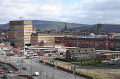
Transport

The M60 motorway, cuts through the west end of Ashton (Junction 23). Regular rail services on the Huddersfield Line between Manchester (Victoria) and Huddersfield stop at Ashton-under-Lyne railway station in the town centre. An extension of the Manchester Metrolink was intended to go as far as Ashton, however due to a cutback in funding, plans have been scaled back and the line will only go as far as Droylsden.[99] Ashton also has one of the busiest bus stations in Greater Manchester. It is planned to be developed and extended in the coming years.
Education
The town included a specialist Sports College, the secondary school Hartshead Sports College, however in September 2008 this was merged with another local school, Stamford High School, to form the New Charter Academy.[100] The academy was so named due to sponsorship by the New Charter Housing Trust.
Another specialist secondary school is St. Damians Science College, situated next door to Hartshead Sports College on Lees Road Ashton.
Ashton Sixth Form College is a centre for further education.[101]
Sports
The most prominent football teams are Ashton United F.C. and Curzon Ashton F.C.. Ashton United play at Hurst Cross stadium and Curzon Ashton at the Tameside stadium on Richmond Street. The Richmond Park Athletics Stadium, also on Ricmond Street, is a synthetic running track with a grass infield[102] and is home to the East Cheshire Harriers & Tameside AC and the Ashton Cricket Club. This team has won the Central Lancashire Cricket League's first and second division twice each, and the Wood Cup, four times.[103]
Public services
Home Office policing in Ashton-under-Lyne is provided by the Greater Manchester Police. The force's "(G) Division" have their divisional headquarters for policing Tameside in the town.[4][104] Public transport is co-ordinated by the Greater Manchester Passenger Transport Executive. Statutory emergency fire and rescue service is provided by the Greater Manchester Fire and Rescue Service, which has one station on Slate Lane.[105]
The Tameside General Hospital is a large NHS hospital on the outskirts of the town,[106] administrated by Tameside Hospital NHS Foundation Trust.[107] The North West Ambulance Service provides emergency patient transport. Other forms of health care are provided for locally by several small clinics and surgeries.
Waste management is co-ordinated by the local authority via the Greater Manchester Waste Disposal Authority.[108] Ashton's Distribution Network Operator for electricity is United Utilities;[109] there are no power stations in the town. United Utilities also manages the drinking and waste water.[109]
Notable people
Sir Geoff Hurst and Simone Perrotta were both born in Ashton-under-Lyne. They share winning the FIFA World Cup in common. Geoff Hurst was part of the England side that won the 1966 World Cup and is the only person to have scored a hat-trick in a World Cup final, and Perrotta won with Italy in 2006.[110] England international mid-fielder Henry Cockburn was also born in the town.[111] Other footballers who were born in Ashton-under-Lyne include Mark Robins, who manages Rotherham United F.C.,[112] Trevor Ross,[113] Alan Wright,[114] Gordon Taylor,[115] and Bert Whalley, who died in the 1958 Munich air disaster.[116]
Cricketers Andrew Harris, Harry Pilling and Gary Yates were all born in Ashton-under-Lyne. Harris played for Derbyshire and currently plays for Nottinghamshire.[117] Pilling played for Lancashire between 1962 and 1980.[118] Yates played for Lancashire between 1990 and 2002 and coaches the Lancashire second XI.[119]
George Formby, Sr., the music hall entertainer and father of the music hall and cinema star George Formby was born "James Lawler Booth" in the town in 1875.[120]Brian Wilde, best known for his roles in Last of the Summer Wine and Porridge, was born in Ashton before he moved with his family at a young age.[121] Several Coronation Street actors are also associated with the town; Amanda Barrie,[122] Dawn Acton,[123] and Sean Wilson was born in Ashton[124] while Bill Tarmey,[125] Roy Barraclough,[126] Sue Devaney all live in the town.[127]
John Louis Petit, who was born in Ashton, was a 19th-century antiquarian who drew examples of the architecture and landscape of Lancashire.[128] Mary Ann Britland who was from Ashton was the first woman hanged at Strangeways Prison.[129] Thomas Earnshaw was a late 18th-century watchmaker.[130] Albert E. Richardson, who designed the Teasmade[131] Arthur Brooke who was a founder of the Brooke Bond Tea Company.[132] And Evan Leigh was a 19th-century author, inventor, and engineer from the town.[133]
Other people born in the town include Margaret Beckett, who became Britain's first female Foreign Secretary in 2006;[134] journalist Simon Hoggart;[135] and pianist and actress Sunny Rogers.[136] Lisa Huo, a Big Brother contestant in 2006,[137] and John Kilbride, a Moors Murders victim, are also from the town.[138] David Vaughan attended art school in Ashton and lives in Tameside.[139]
References
- ↑ 1.0 1.1 1.2 1.3 1.4 1.5 1.6 1.7 "A select gazetteer of local government areas, Greater Manchester County". Greater Manchester County Record Office (2003-07-31). Retrieved on 20 September 2008.
- ↑ 2.0 2.1 2.2 2.3 Lewis 1848, p. 90-96.
- ↑ 3.0 3.1 3.2 John Marius Wilson (2008-09-03). "Imperial Gazetteer of England and Wales (1870-72) - Ashton-under-Lyne". genuki.org.uk. Retrieved on 2008-09-18.
- ↑ 4.0 4.1 Greater Manchester Police (2006-01-25). "Ashton". gmp.police.uk. Retrieved on 2008-09-19.
- ↑ Nevell (1992), p. 11.
- ↑ Nevell (1992), p. 25.
- ↑ Nevell (1992), p. 30.
- ↑ Nevell (1992), p. 71.
- ↑ Nevell and Walker (1998), pp. 40–41.
- ↑ Nevell (1992), pp. 77–83.
- ↑ Nevell (1997), p. 32.
- ↑ University of Nottingham's Institute for Name-Studies, Ashton-under-Lyne, nottingham.ac.uk, http://www.nottingham.ac.uk/english/ins/kepn/detailpop.php?placeno=12870, retrieved on 2008-09-18
- ↑ Nevell (1992), pp. 84–85.
- ↑ Nevell (1992), p. 88.
- ↑ 15.0 15.1 "Township Information — Ashton". Tameside.gov.uk. Retrieved on 12 September 2008.
- ↑ 16.0 16.1 Nevell (1991), p. 17.
- ↑ Redhead, Norman, in: Hartwell, Hyde and Pevsner (2004), p. 18.
- ↑ Nevell and Walker (1998), p. 47.
- ↑ 19.0 19.1 19.2 19.3 Nevell and Walker (1998), p. 54.
- ↑ Nevell (1991), p. 60.
- ↑ 21.0 21.1 21.2 21.3 "Ashton-under-Lyne town centre". Tameside.gov.uk. Retrieved on 13 September 2008.
- ↑ 22.0 22.1 Nevell (1993), p. 146.
- ↑ Griffith (1898), p. 380.
- ↑ Griffith (1898), p. 381.
- ↑ Griffith (1898), pp. 379, 382.
- ↑ "The Black Knight Pageant". Ashton-under-Lyne.com. Retrieved on 20 September 2008.
- ↑ Nevell and Walker (1998), p. 48.
- ↑ McNeil & Nevell 2000, p. 54.
- ↑ 29.0 29.1 Burke and Nevell (1996), p. 123.
- ↑ Nevell (1993), p. 99.
- ↑ Frangopulo 1977, p. 25.
- ↑ McNiel and Nevell (2005), p. 54.
- ↑ Powell 1986, p. 35.
- ↑ 34.0 34.1 34.2 Nevell (1993), p. 35.
- ↑ Nevell and Walker (1999), p. 49.
- ↑ Nevell and Roberts (2003), pp. 19, 22, 31–32.
- ↑ 37.0 37.1 Nevell (1993), p. 151.
- ↑ Nevell (1994), pp. 44–45.
- ↑ "Currency converter". NationalArchives.gov.uk. Retrieved on 12 September 2008.
- ↑ Nevell (1993), p. 127.
- ↑ Nevell (1993), p 23.
- ↑ Nevell (1993), pp. 149–151.
- ↑ 43.0 43.1 43.2 Nevell (1993), p. 102.
- ↑ Nevell (1993), p. 37.
- ↑ Nevell (1993), p. iii.
- ↑ Sue Carr (21 October 2004). "Ashton celebrates as new market opens its doors". Tameside Advertiser. Retrieved on 18 September 2008.
- ↑ Sue Carr (14 December 2004). "Rebirth of a market". Tameside Advertiser. Retrieved on 3 September 2008.
- ↑ "The parish of Ashton-under-Lyne - Introduction, manor & boroughs | British History Online". British-history.ac.uk. Retrieved on 2008-09-21.
- ↑ "A vision of Ashton under Lyne AP/CP". visionofbritain.org.uk. Retrieved on 2008-09-19.
- ↑ A vision of Britain through time. "A vision of Ashton under Lyne MB". Retrieved on 3 June 2007.
- ↑ Tameside Metropolitan Borough Council (27 September 2006). "Town twinning". Tameside.gov.uk. Retrieved on 4 September 2008.
- ↑ Tameside Metropolitan Borough Council. "Know you councillor". Tameside.gov.uk. Retrieved on 15 September 2008.
- ↑ Nevell (1992), pp.10–11.
- ↑ "KS06 Ethnic group: Census 2001, Key Statistics for urban areas". Statistics.gov.uk (25 January 2005). Retrieved on 5 August 2008.
- ↑ 55.0 55.1 55.2 "Tameside Metropolitan Borough key statistics". Statistics.gov.uk. Retrieved on 12 September 2008.
- ↑ "Tameside Census Snapshot" (PDF). Tameside MBC (2004). Retrieved on 17 January 2008.
- ↑ "KS01 Usual resident population: Census 2001, Key Statistics for urban areas". Statistics.gov.uk (7 February 2005). Retrieved on 12 September 2008.
- ↑ "KS04 Marital status: Census 2001, Key Statistics for urban areas". Statistics.gov.uk (2 February 2005). Retrieved on 12 September 2008.
- ↑ "KS20 Household composition: Census 2001, Key Statistics for urban areas". Statistics.gov.uk (2 February 2005). Retrieved on 12 September 2008.
•"Tameside Metropolitan Borough household data". Statistics.gov.uk. Retrieved on 12 September 2008. - ↑ "KS13 Qualifications and students: Census 2001, Key Statistics for urban areas". Statistics.gov.uk (2 February 2005). Retrieved on 12 September 2008.
- ↑ "KS13 Qualifications and students: Census 2001, Key Statistics for urban areas" (7 February 2005). Retrieved on 12 September 2008.
- ↑ "Ashton under Lyne social class". Vision of Britain. Retrieved on 15 September 2008.
•"Percentage of Working-Age Males in Class 1 and 2". Vision of Britain. Retrieved on 15 September 2008.
•"Percentage of Working-Age Males in Class 4 and 5". Vision of Britain. Retrieved on 15 September 2008. - ↑ "KS07 Religion: Census 2001, Key Statistics for urban areas". Statistics.gov.uk (2 February 2005). Retrieved on 5 August 2008.
- ↑ Nevell (1991), pp. 121, 135.
- ↑ Nevell (1993), p. 168.
- ↑ Nevell (1993), p. 27.
- ↑ "The Murphy Riots in Ashton under Lyne". Ashton-under-Lyne.com. Retrieved on 9 December 2007.
- ↑ Nevell (1993), p. 36.
- ↑ "Facts about Ashton". Tameside.gov.uk. Retrieved on 16 September 2008.
- ↑ Nevell (1993), p. 12.
- ↑ 71.0 71.1 "KS09a Economic activity - all people: Census 2001, Key Statistics for urban areas". Statistics.gov.uk (3 February 2005). Retrieved on 15 September 2008.
- ↑ 72.0 72.1 "Tameside Local Authority economic activity". Statistics.gov.uk. Retrieved on 15 September 2008.
- ↑ Nevell (1991), p. 52.
- ↑ Nevell (1993), pp. 35, 83.
- ↑ Nevell (1993), pp. 35–39
- ↑ Nevell (1993), p. 101.
- ↑ Tameside Metropolitan Borough Council (November 1992). "Appendix 6: Conservation Areas and Scheduled Ancient Monuments (Policies C11 and C30)". Tameside.gov.uk. Retrieved on 4 September 2008.
- ↑ "Ashton market". Tameside.gov.uk (3 November 2007). Retrieved on 20 September 2008.
- ↑ David Thame (13 June 2006). "Ashton's mall on the up". Manchester Evening News. Retrieved on 3 September 2008.
- ↑ "Ikea's superstore plans approved". BBC Online (11 January 2006). Retrieved on 3 September 2008.
- ↑ Emma Unsworth (16 October 2006). "IKEA's finally here". Manchester Evening News. Retrieved on 3 September 2008.
- ↑ "Completed development". Ashton-Moss.com. Retrieved on 15 September 2008.
- ↑ David Thame (23 May 2005). "The big spenders are in town!". Manchester Evening News. Retrieved on 15 September 2008.
- ↑ David Thame (5 July 2005). "Ashton's eastern promise". Manchester Evening News. Retrieved on 15 September 2008.
- ↑ "Street killings hit town's night spots". Tameside Advertiser. MEN Media (23 May 2002). Retrieved on 20 August 2008.
- ↑ "KS11a Industry of employment - all people: Census 2001, Key Statistics for urban areas". Statistics.gov.uk (3 February 2005). Retrieved on 15 September 2008.
- ↑ Nevell and Walker (2001), pp. 59, 61.
- ↑ Nevell and Walker (2001), pp. 63–64.
- ↑ "From far-flung Canada to Corrie". Manchester Evening News (17 September 2008). Retrieved on 19 September 2008.
- ↑ Burke and Nevell (1996), pp. 118–119.
- ↑ "Ashton-under-Lyne Town Hall". Images of England. Retrieved on 18 September 2008.
- ↑ "Museum of the Manchester Regiment". 24hourmuseum.org.uk. Retrieved on 4 September 2008.
- ↑ Wyke (2005), p. 357.
- ↑ Burke and Nevell (1996), pp.144–145.
- ↑ "Hartshead Pike". Tameside.gov.uk (13 October 2006). Retrieved on 20 September 2008.
- ↑ Sue Carr (15 November 2006). "Save The Witchwood". TamesideAdvertiser.co.uk. Retrieved on 26 April 2008.
- ↑ Don Frame (24 January 2005). "Party as stars' pub is saved". Manchester Evening News. Retrieved on 29 January 2008.
- ↑ 98.0 98.1 98.2 Public Monuments and Sculpture Association (16 June 2003), Ashton-under-Lyne War Memorial, pmsa.cch.kcl.ac.uk, http://pmsa.cch.kcl.ac.uk/MR/MR-TAM11.htm Retrieved on 19 September 2008.
- ↑ "Metrolink wins a 'Little Bang'". Manchester Evening News (6 July 2006). Retrieved on 13 September 2008.
- ↑ Charter Academy Home Page Details of the merger.
- ↑ "Ashton Sixth Form College". Asfc.ac.uk. Retrieved on 2008-09-21.
- ↑ Richmond Park Athletics Stadium Retrieved on 22 September 2008
- ↑ "Oldham Cricket Club: Wood Cup". OldhamCC.co.uk. Retrieved on 1 September 2008.
- ↑ Greater Manchester Police (2006-01-25). "Your Area — Tameside". gmp.police.uk. Retrieved on 2008-09-19.
- ↑ Greater Manchester Fire and Rescue Service, Ashton-Under-Lyne Fire Station, manchesterfire.gov.uk, http://www.manchesterfire.gov.uk/my-area/tameside/ashton-under-lyne-fire-station.aspx, retrieved on 2007-10-31
- ↑ "Profile". tamesidehospital.nhs.uk. Retrieved on 2008-09-19.
- ↑ "About the Trust". tamesidehospital.nhs.uk. Retrieved on 2008-09-19.
- ↑ Greater Manchester Waste Disposal Authority (2008), Greater Manchester Waste Disposal Authority (GMWDA), gmwda.gov.uk, http://www.gmwda.gov.uk/, retrieved on 2008-02-08
- ↑ 109.0 109.1 United Utilities (2007-04-17), Tameside, unitedutilities.com, http://www.unitedutilities.com/?OBH=4188&ID=1419, retrieved on 2008-09-19
- ↑ Stuart James (6 July 2006). "Ashton-under-Lyne cheers Perrotta". The Guardian. Retrieved on 12 September 2008.
- ↑ "Henry Cockburn". The Independent (17 February 2004). Retrieved on 12 September 2008.
- ↑ "Mark Robins". MUFCinfo.com. Retrieved on 12 September 2008.
- ↑ "Everton Player Stats Trevor Ross". EvertonFC.com. Retrieved on 12 September 2008.
- ↑ "Alan Wright". The Guardian. Retrieved on 12 September 2008.
- ↑ James Lawton (24 November 2001). "Gordon Taylor: The players' champion". The Independent. Retrieved on 12 September 2008.
- ↑ Laura Breen (29 July 2005). "Portland Basin Museum: Football Fever". Manchester Evening News. Retrieved on 12 September 2008.
- ↑ "Andrew Harris player profile". Cricinfo.com. Retrieved on 28 August 2007.
- ↑ "Harry Pilling player profile". Cricinfo.com. Retrieved on 28 August 2007.
- ↑ "Gary Yates player profile". Cricinfo.com. Retrieved on 28 August 2007.
- ↑ Simon Louvish (6 December 2002). "That lad will go far!". The Guardian. Retrieved on 22 September 2008.
- ↑ "Brian Wilde". The Daily Telegraph (21 March 2008). Retrieved on 16 September 2008.
- ↑ Natalie Anglesey (13 July 2006). "Amanda's Bad and loving it!". Manchester Evening News. Retrieved on 16 September 2008.
- ↑ Tim Lambert. "Famous people from North West England". LocalHistories.org. Retrieved on 16 September 2008.
- ↑ Ian Wylie (13 February 2006). "Sean frozen out of Ice show". Manchester Evening News. Retrieved on 16 September 2008.
- ↑ "Friends of Young Carers Charity Launch". Tameside.gov.uk (11 September 2007). Retrieved on 16 September 2008.
- ↑ "Flintoff and Street star honoured". BBC Online (31 December 2005). Retrieved on 16 September 2008.
- ↑ "Girls behind". TheLowry.com (9 August 2007). Retrieved on 16 September 2008.
- ↑ "Historic exhibition for Lytham". Lytham St Annes Express (24 June 2008). Retrieved on 16 September 2008.
- ↑ Tameside Local Studies & Archives Centre staff (2006). "Tameside bibliography" (PDF). Tameside.gov.uk. Retrieved on 16 September 2008.
- ↑ Nevell (1994), p. 75.
- ↑ "An automatic tea-making machine, c 1902.". ScienceMuseum.org.uk. Retrieved on 16 September 2008.
- ↑ Nevell (1994), p. 68.
- ↑ 'The parish of Ashton-under-Lyne: Introduction, manor & boroughs', A History of the County of Lancaster: Volume 4 (1911), pp. 338-347. URL: http://www.british-history.ac.uk/report.aspx?compid=41438. Date accessed: 16 September 2008.
- ↑ "Margaret Beckett". BBC Online. Retrieved on 16 September 2008.
- ↑ "The Hands of History: Parliamentary Sketches 1997–2007". Kingston.ac.uk. Retrieved on 16 September 2008.
- ↑ "Sunny Rogers". The Independent (28 January 2006). Retrieved on 16 September 2008.
- ↑ Adam Derbyshire (24 May 2006). "'I'm wild, crazy and sexy' ... meet Big Brother Lisa". Manchester Evening News. Retrieved on 16 September 2008.
- ↑ "Court cleared for Moors murder charges hearing". The Guardian (7 December 1965). Retrieved on 16 September 2008.
- ↑ "To hell and back". Manchester Evening News (7 February 2003). Retrieved on 16 September 2008.
Bibliography
- Burke, Tom; Nevell, Mike (1996). Buildings of Tameside. Tameside Metropolitan Borough and University of Manchester Archaeological Unit. ISBN 1-871324-14-9.
- Frangopulo, N. J. (1977). Tradition in Action: The Historical Evolution of the Greater Manchester County. Wakefield: EP. ISBN 0-7158-1203-3.
- Griffith, Kate (1898). "The Black Lad of Ashton-under-Lyne". Folklore (Taylor & Francis, Ltd) 8 (4). http://www.jstor.org/pss/1253739.
- Hartwell, Clare; Matthew Hyde and Nikolaus Pevsner (2004). Lancashire : Manchester and the South-East. The buildings of England. New Haven, Conn.; London: Yale University Press. ISBN 0-300-10583-5.
- Lewis, Samuel (1848), A Topographical Dictionary of England, Institute of Historical Research, ISBN 978-0806315089
- McNeil, R & Nevell, M (2000), A Guide to the Industrial Archaeology of Greater Manchester, Association for Industrial Archaeology, ISBN 0-9528930-3-7
- Nevell, Mike (1991). Tameside 1066-1700. Tameside Metropolitan Borough and University of Manchester Archaeological Unit. ISBN 1-871324-02-5.
- Nevell, Mike (1992). Tameside Before 1066. Tameside Metropolitan Borough and Greater Manchester Archaeological Unit. ISBN 1-871324-07-6.
- Nevell, Mike (1993). Tameside 1700-1930. Tameside Metropolitan Borough and University of Manchester Archaeological Unit. ISBN 1-871324-08-4.
- Nevell, Mike (1994). The People Who Made Tameside. Tameside Metropolitan Borough Council. ISBN 1-871324-12-2.
- Nevell, Mike (1997). The Archaeology of Trafford. Trafford Metropolitan Borough Council with the University of Manchester Archaeological Unit. ISBN 1-870695-25-9.
- Nevell, Mike; John Roberts (2003). The Park Bridge Ironworks and the archaeology of the Wrought Iron Industry in North West England, 1600 to 1900. Tameside Metropolitan Borough with University of Manchester Archaeological Unit. ISBN 1-871324-27-0.
- Nevell, Mike; Walker, John (1998). Lands and Lordships in Tameside. Tameside Metropolitan Borough Council with the University of Manchester Archaeological Unit. ISBN 1-871324-18-1.
- Nevell, Mike; Walker, John (2001). Portland Basin and the archaeology of the Canal Warehouse. Tameside Metropolitan Borough with University of Manchester Archaeological Unit. ISBN 1-871324-25-4.
- Powell, Rob (1986). In the Wake of King Cotton. Rochdale Art Gallery.
- Wyke, Terry (2005). Public Sculpture of Greater Manchester. Liverpool University Press. ISBN 0853235678. http://books.google.co.uk/books?id=_h5hIINSn3cC&pg=PA357&lpg=PA357&dq=Hartshead+hill&source=web&ots=FfHGhSq1QM&sig=HgqijSQupLE5wF95tXnP5IjRmKU&hl=en&sa=X&oi=book_result&resnum=7&ct=result#PPA357,M1.
External links
|
|||||||||||||||||