Ashgabat
| Ashgabad Aşgabad Poltoratsk |
|
 |
|
|
Ashgabad
|
|
| Coordinates: | |
| Country | |
|---|---|
| Province | Ahal Province |
| founded | 1818 |
| Population (2001) | |
| - Total | 695,300 |
Ashgabat (Aşgabat in Turkmen) (or formerly Ashkhabad or Poltoratsk) is the capital and largest city of Turkmenistan, a country in Central Asia. It has a population of 695,300 (2001 census estimate) and is situated between the Kara Kum desert and the Kopet Dag mountain range. Ashgabat has a primarily Turkmen population, with minorities of ethnic Russians, Armenians, and Azeris. It is 250 km from the second largest city in Iran, Mashhad.
Contents |
Names
Ashgabat is Aşgabat in Turkmen, Ашхабад (Ašxabád) in Russian, and عشقآباد (UniPers: Ešq-âbâd) in Persian. From the Russian Revolution until 1927, the city was renamed Poltoratsk after a local revolutionary. Before 1991, the city was usually spelled Ashkhabad in English, a transliteration of the Russian form. It has also been spelled Ashkhabat and Ashgabad. The name is believed to derive from the Persian Ashk-ābād meaning "the City of Arsaces." Another explanation is that the name is a dialect version of the Arabic-derived Persian word of عشق (eshq meaning "love") and Persian آباد (ābād meaning "cultivated place" or "city", etymologically "abode"), and hence loosely translates as "the city of love.".
History
Ashgabat is a relatively young city, growing out of a village of the same name established in 1818. It is not far from the site of Nisa, the ancient capital of the Parthians and the ruins of the Silk Road city of Konjikala, which had been destroyed either by an earthquake in the first decade BC, or by the Mongols in the 13th century.
It remained a part of Persia until 1884. In 1869, Russian soldiers built a fortress on a hill near the village, and this added security soon attracted merchants and craftsmen to the area. Tsarist Russia annexed the region in 1884 from Persia under he terms of Akhal Treaty, and chose to develop the town as a regional center due to its proximity to the border of British-influenced Persia. It was regarded as a pleasant town with European style buildings, shops and hotels.
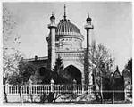
In 1908, the first Bahá'í House of Worship was built in Ashgabat. After being taken by Soviet officials, it was seriously damaged as a result of earthquake in 1948 and was demolished by the Soviet authorities in 1963. [1] [2]
Soviet rule was established, lost and then regained in 1917, and the city was renamed Poltoratsk after a local revolutionary. The name "Ashgabat" was restored in 1927 when the Communist Party was properly established in Turkmenistan, though it was usually known by the Russian form Ashkhabad. From this period onward, the city experienced rapid growth and industrialisation, although this was severely disrupted by a major earthquake on October 6 1948. An estimated 7.3 on the Richter scale, the earthquake killed 110-176,000[1][2][3] (2/3 the population of the city), although the official number announced by Soviet news was only 14,000.
Economy

Ashgabat is primarily a government and administrative center. The principal industries are cotton textiles and metal working. It is a major stop on the Trans-Caspian railway.
The city is served by Ashgabat Airport.
Climate
The Kopet-Dag mountain range is about 25 km to the south, and Ashgabat's northern boundary touches the Kara-Kum desert. Because of this location, Ashgabat has an arid climate with hot and dry summers and mild and short winters. Summer temperatures can easily reach 45°C (113°F) for long periods of time. In mid-July it can touch 52°C (126°F). June through August are hot, with night temperatures normally not falling lower than 32°C (90°F). Autumn is notably less hot, but during the day temperatures can still be 40°C (104°F) whereas nights are pleasantly cooler. Winter normally starts in December; snow is rare and there can be a lot of rain. Normally, winter temperatures are 10-15°C (50-60°F), and rarely can go as low as -10°C (14°F) in January. The lowest temperature was recorded in January 1969, -28°C (-18°F).
Notable buildings
Museums include the Turkmen Fine Arts Museum, noted for its impressive collection of woven carpets, and a Turkmen history museum Ashgabat National Museum of History which has artifacts dating back to the Parthian and Persian civilisations. The Academy of Sciences of Turkmenistan is an important institute of higher learning. Large mosques include the Azadi Mosque (which resembles the Blue Mosque in Istanbul), the Khezrety Omar Mosque, and the futuristic Iranian Mosque. Ashgabat is also home to the Arch of Neutrality, which is a large tripod on which there is a golden statue of former President Saparmurat Niyazov (also known and generally referred to as Turkmenbashi, or leader of the Turkmens). This statue rotates in order to always face the sun during daylight hours. It is said to be made of pure gold.
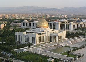
- Türkmenbaşı Palace presidential headquarters
- Rukhiyet Palace
Sister cities
Notes, References
External links
- Ashgabat in pictures.
- Ashgabat Photo Gallery.
- impressions of Ashgabat (German)
- Ashgabat Photo Gallery. Pictures of modern Ashgabat.
- Page on modern Ashgabat (Russian)