Arunachal Pradesh
| ?Arunachal Pradesh India |
|

|
|
| Coordinates: | |
| Time zone | IST (UTC+5:30) |
| Area | 83,743 km² (32,333 sq mi) |
| Capital | Itanagar |
| Largest city | Itanagar |
| District(s) | 16 |
| Population • Density |
1,091,117 (26th) • 13 /km² (34 /sq mi) |
| Language(s) | English |
| Governor | Joginder Jaswant Singh (2008-) |
| Chief Minister | Dorjee Khandu (2007-) |
| Established | 1987-02-20 |
| Legislature (seats) | Unicameral (60) |
| ISO abbreviation | IN-AR |
| Website: arunachalpradesh.nic.in | |
 |
|
Arunachal Pradesh pronunciation (Hindi: अरुणाचल प्रदेश Aruṇācal Pradeś) is the easternmost state of India. Arunachal Pradesh shares a border with the states of Assam to the south and Nagaland to the southeast. Burma/Myanmar lies towards the east, Bhutan towards the west, and Tibet to the north. Itanagar is the capital of the state. Though Arunachal Pradesh is an Indian State, the People's Republic of China and the Republic of China claim portions of the state as South Tibet.[1][2]
Arunachal Pradesh means "land of the dawn lit mountains"[3] in Sanskrit. It is also known as "land of the rising sun"[4] ("pradesh" means "state" or "region") in reference to its position as the easternmost state of India. Most of the people living in Arunachal Pradesh are of Tibeto-Burman origin. 16% of the population are immigrants, including 30,000 Bangladeshi and Chakma expatriates, and migrants from other parts of India, notably Assam and Nagaland.[5] Part of the famous Ledo Burma Road, which was a lifeline to China during World War II, passes through the state.
Contents |
History
The first ancestors of the tribal groups migrated from Tibet during the prehistoric period, and were joined by Thai-Burmese counterparts later. Except for the northwestern parts of the state, little is known about the history of Arunachal Pradesh, although the Adi tribe had legendary knowledge of the history. The earliest references to Arunachal are found in the era of Mahabharata, Ramayana and other Vedic legends. Several characters, such as Princess Rukmini, King Bhismaka and Lord Parashurama, were referred to as people from the region in the Mahabharata.
Recorded history was only available in the Ahom chronicles during the 16th century. The tribal Monpa and Sherdukpen do keep historical records of the existence of local chiefdoms in the northwest as well. Northwestern parts of this area came under the control of the Monpa kingdom of Monyul, which flourished between 500 B.C. and 600 A.D. This region then came under the loose control of Tibet and Bhutan, especially in the Northern areas. The remaining parts of the state, especially those bordering Myanmar, came under the control of the Ahom and the Assamese until the annexation of India by the British in 1858.
Recent excavations of ruins of Hindu temples such as the 14th Malinithan at the foot of the Siang hills in West Siang shed new light on the ancient history of Arunachal Pradesh. Paintings of the Hindu gods and altars remained untouched for many years. They attracted many local pilgrims. Another notable heritage site, Bhismaknagar, suggested that the Idu Mishmi had a local civilisation. The third heritage site, the 400-year-old Tawang monastery in the Tawang district, also provides historical evidence of the Buddhist tribal peoples. Historically, the area had a close relationship with Tibetan people and Tibetan culture, for example the sixth Dalai Lama Tsangyang Gyatso was born in Tawang.[6]

In 1913-1914 representatives of China, Tibet and Britain negotiated a treaty in India: the Simla Convention. This treaty's objective was to define the borders between Inner and Outer Tibet as well as between Outer Tibet and British india. British administrator, Sir Henry McMahon, drew up the 550 mile (890 km) McMahon Line as the border between British India and Outer Tibet during the Simla Conference. The Tibetan and British representatives at the conference agreed to the line, which ceded Tawang and other Tibetan areas to the imperial British Empire.The Chinese representative had no problems with the border between British India and Outer Tibet, however on the issue of the boder between Outer Tibet and Inner Tibet the talks broke down. Thus, the Chinese representative refused to accept the agreement and walked out. The Tibetan Government and British Government went ahead with the Simla Agreement and declared that the benefits of other articles of this treaty would not be bestowed on China as long as it stays out of the purview. The Chinese position since then has been that since China had suzerainty over Tibet, the line was invalid without Chinese agreement. Furthermore, by refusing to sign the Simla documents, the Chinese Government had escaped according any recognition to the validity of the McMahon Line.[7]
Simla was initially rejected by the Government of India as incompatible with the 1907 Anglo-Russian Convention. However, this agreement(Anglo-Russian Convention) was renounced by Russia and Britain jointly in 1921, thus making the Simla Conference official. However, with the collapse of Chinese power in Tibet the line had no serious challenges as Tibet had signed the convention, therefore it was forgotten to the extent that no new maps were published until 1935, when interest was revived by civil service officer Olaf Caroe. The Survey of India published a map showing the McMahon Line as the official boundary in 1937.[14][13] In 1938, the British finally published the Simla Convention as a bilateral accord two decades after the Simla Conference; in 1938 the Survey of India published a detailed map showing Tawang as part of NEFA. In 1944 Britain established administrations in the area, from Dirang Dzong in the west to Walong in the east. Tibet, however, altered its position on the McMahon Line in late 1947 when the Tibetan government wrote a note presented to the newly independent Indian Ministry of External Affairs laying claims to the Tibetan district (Tawang) south of the McMahon Line.[8] The situation developed further as India became independent and the People's Republic of China was established in the late 1940s. With the PRC poised to take over Tibet, India unilaterally declared the McMahon Line to be the boundary in November 1950, and forced the last remnants of Tibetan administration out of the Tawang area in 1951.[9][10] The PRC has never recognized the McMahon Line. (In 1959 a suppressed Tibetan uprising resulted in PRC's abolition of Tibet's self-ruling government headed by the Dalai Lama. The Dalai Lama fled to Dharamsala, India, where he continues to lead the Tibetan Government-in-Exile. Maps published by the Tibetan Government-in-Exile now show the McMahon Line as the southern border of Tibet.
The NEFA (North East Frontier Agency) was created in 1954. The issue was quiet during the next decade or so of cordial Sino-Indian relations, but erupted again during the Sino-Indian War of 1962. The cause of the escalation into war is still disputed by both Chinese and Indian sources. During the war in 1962, the PRC captured most of the NEFA. However, China soon declared victory and voluntarily withdrew back to the McMahon Line and returned Indian prisoners of war in 1963. The war has resulted in the termination of barter trade with Tibet, although in 2007 the state government has shown signs to resume barter trade with Tibet.[11]
Of late, Arunachal Pradesh faces threat from resistance groups, notably the National Socialist Council of Nagalim (NSCN), who were believed to have base camps in the districts of Changlang and Tirap.[12] There were occasional reports of these groups harassing the local people.[13]
Geography


Much of Arunachal Pradesh is covered by the Himalayas. However, parts of Lohit, Changlang and Tirap are covered by the Patkai hills. Kangto, Nyegi Kangsang, the main Gorichen peak and the Eastern Gorichen peak are some of the highest peaks in this region of the Himalayas.
In 2006 Bumla pass in Tawang was opened to traders for the first time in 44 years. Traders from both sides of the pass were permitted to enter each other's territories.
The Himalayan ranges that extend up to the eastern Arunachal separate it from China. The ranges extend toward Nagaland, and form a boundary between India and Burma in Changlang and Tirap district, acting as a natural barrier called Patkai Bum Hills. They are low mountains compared to the Greater Himalayas.[14]
Climate
The climate of Arunachal Pradesh varies with elevation. Areas that are at a very high elevation in the Upper Himalayas close to the Tibetan border enjoy an alpine or Tundra climate. While below the Upper Himalayas are the Middle Himalayas, where people experience a climate which is temperate. Areas at the sub-Himalayan and sea-level elevation generally experience a humid sub-tropical climate, along with the hot summers and mild winters.
Arunchal Pradesh receives heavy rainfall of 80 to 160 inches (2,000 to 4,000 mm) annually, most of it between May and September. The mountain slopes and hills are covered with alpine, temperate, and subtropical forests of dwarf rhododendron, oak, pine, maple, fir, and juniper; sal (Shorea) and teak are the main economic species.
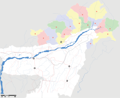
Sub-divisions
Arunachal Pradesh is divided into sixteen districts, each administered by a district collector, who sees to the needs of the local people. Especially along the Tibetan border, the Indian army has considerable presence due to the concern about Chinese intentions. Special permits called Inner Line Permits (ILP) are required to enter Arunachal Pradesh through any of it checkgates on its border with Assam.
Districts of Arunachal Pradesh:
- Anjaw District
- Changlang District
- East Kameng
- East Siang
- Kurung Kumey
- Lohit District
- Lower Dibang Valley
- Lower Subansiri
- Papum Pare
- Tawang District
- Tirap District
- Upper Dibang Valley
- Upper Subansiri
- Upper Siang
- West Kameng
- West Siang
Economy
This is a chart of trend of gross state domestic product of Arunachal Pradesh at market prices estimated by the Ministry of Statistics and Programme Implementation with figures in millions of Indian Rupees.
| Year | Gross State Domestic Product |
|---|---|
| 1980 | 1,070 |
| 1985 | 2,690 |
| 1990 | 5,080 |
| 1995 | 11,840 |
| 2000 | 17,830 |
Arunachal Pradesh's gross state domestic product for 2004 is estimated at $706 million in current prices. Agriculture is the primary driver of the economy. Jhum, the local word for shifting cultivation, which was widely practised among the tribal groups has come to be less practiced. Arunachal Pradesh has close to 61,000 square kilometers of forests, and forest products are the next most significant sector of the economy. Among the crops grown here are rice, maize, millet, wheat, pulses, sugarcane, ginger and oilseeds. Arunachal is also ideal for horticulture and fruit orchards. Its major industries are sawmills, plywood (these two trades however have been stopped by law), rice mills, fruit preservation units and handloom handicrafts.
Demographics

63% of the Arunachalis belong to 19 major tribes and 85 other tribes. Most of them are either of Tibeto-Burman or Tai-Burmese origin. Another 35% of the population are made up of immigrants, including 31,000 Bengali, Bodo, Hajong and Chakma expatriates from Bangladesh, and immigrants from neighboring Assam, Nagaland and other parts of India. The largest major tribes include the Adi, Galo, Nishi, Khamti, Monpa and Apatani.
Literacy rose to 54.74% from 41.59% in 1991. The literate population numbers 487,796. 2001 census data by Government of India shows that[15]
Twenty percent of Arunachal's population are animist, who follow animistic religions such as Donyi-Polo and Rangfrah. Thirty-five percent are Hindus including the Nocte and Miri peoples.[15][16] Another 13% are practicing Buddhists.[15] Tibetan Buddhism predominates in the districts of Tawang, West Kameng and isolated regions adjacent to Tibet. Theravada Buddhism is practiced by groups living near the Burmese border. Around 19% of the population are followers of the Christian faith[17].
There has been a law enacted to protect the indigeneous religions (e.g., Donyi-Poloism, Buddhism) in Arunanchal Pradesh against the spread of Christianity.
Transport
The state's airports are located at Daparjio, Ziro, Along, Tezu and Pasighat. However, owing to the rough terrain, these airports are mostly small and cannot handle many flights, they were actually used for transportation of food, when these parts were not connected by the roads. Arunachal Pradesh has two highways; the 336km (205 miles) National Highway 52, completed in 1998, connects Jonai with Dirak.[18] There is another highway which connects Tezpur in Assam with Tawang.[19] Now in 2007, every village is connected by road due to funding provided by the central government. Every small town has got its own bus station and daily bus services are available. All places are connected to Assam, which has increased the trading capacity. A National Highway is being constructed on the famous Stillwell Ledo Road, which connects Ledo in Assam to Jairampur in Arunachal.
Education
The current education system in Arunachal Pradesh is relatively underdeveloped. The state government is expanding the education system in concert with various NGOs like Vivekananda Kendra.
The state also has several reputed schools, colleges and institutions. There are also trust institutes like Pali Vidyapith run by Budhist society. They impart pali script and khamti script apart from normal educational subjects. Khamti is the only tribe in Arunachal Pradesh who have scripts of their own. Library of sciptures are located in number of places in Lohit district and the major one is in Chowkham.
Rajiv Gandhi University, Arunachal Pradesh is the state's premier educational institution,its the only university in whole state. state has got 7 govt. colleges in whole states, in different district, helping the student out there to go for higher education.NERIST (North Eastern Regional Institute of Science and Technology) is playing a very important role in raising the technical and management education.for higher technical education, directorate of technical education conduct exam yearly, so that studne t who qualify can go for higher studies in other state.
Tourism
Arunachal Pradesh attracts tourists from many parts of the world. Tourist attractions include the Namdapha tiger project in Changlang district, Sela lake near to Bomdila, the bamboo bridges hanging over the river. Religious places of interest include Malinithan in Lekhabali and Rukhmininagar near Roing, the place where Rukmini, Lord Krishna's wife in Hindu mythology, is said to have lived; Parshuram Kund in Lohit district, is believed to be the lake where Parshuram washed away all his sins. Rafting and trekking are also available. A visitor's permit from the tourism department is required. [3]
See also
- List of disputed or occupied territories
- List of people from Arunachal Pradesh
- Religion in Arunachal Pradesh
- Sino-Indian relations
Notes
- ↑ "China revives claims on Indian territory". Islamic Republic News Agency. Retrieved on 2007-08-26.
- ↑ India-Taiwan Relations: In Delicate Minuet
- ↑ Arunachal Pradesh - Land, People, Festival, Arts, Tourism, Economy
- ↑ arunachal pradesh
- ↑ Indian Census
- ↑ 仓央嘉措生平疏议 (Biography of Cangyang Gyaco; in Chinese)
- ↑ Lamb, Alastair, The McMahon line: a study in the relations between India, China and Tibet, 1904 to 1914, London, 1966, p529
- ↑ Lamb, 1966, p580
- ↑ The battle for the border
- ↑ India’s China War by Neville Maxwell
- ↑ PM to visit Arunachal in mid-Feb
- ↑ Apang rules out Chakma compromise
- ↑ [1]
- ↑ Trekking in Arunachal,Trekking Tour in Arunachal Pradesh,Adventure Trekking in Arunachal Pradesh
- ↑ 15.0 15.1 15.2 Indian Census
- ↑ [http://www.bharatvani.org/books/wiah/ch9.htm 9. Are Indian tribals Hindus?
- ↑ Census Reference Tables, C-Series Population by religious communities
- ↑ http://parliamentofindia.nic.in/ls/lsdeb/ls10/ses1/0113099101.htm
- ↑ [2]
External links
- Arunachal News [4]
- Arunachal Pradesh at the Open Directory Project
- Official Web Page of the Government of Arunachal Pradesh [5]
- http://savetanii.blogspot.com Blog dedicated to the preservation of Apatani culture and language
- Arunachal community website
| Territorial disputes in East, South, and Southeast Asia | |||
|---|---|---|---|
| Type | Territory | Currently Administered by | Claimants |
| Land: | Aksai Chin | ||
| Arunachal Pradesh | |||
| Baekdu Mountain | |||
| East Turkestan | |||
| Heixiazi/Bolshoy Ussuriysky (Eastern part)2 | |||
| Indo-Bangladesh enclaves3 | |||
| Kashmir3 | |||
| Kachin State | |||
| Kayin State | |||
| Korean Peninsula and its adjacent islands3 | |||
| Mainland China2 | |||
| Mongolia2 | |||
| Pamir Mountains (Northern and central parts)2 | |||
| Wakhan Corridor2 | |||
| Pattani | |||
| Sabah2 | |||
| Shan State | |||
| Sixty-Four Villages East of the Heilongjiang River2 | |||
| Tannu Uriankhai (now Tuva Republic of Russia)2 | |||
| Tibet | |||
| Trans-Karakoram Tract | |||
| Wa State | |||
| Islands and Waters: | Kinmen | ||
| Liancourt Rocks | |||
| Macclesfield Bank | |||
| Matsu | |||
| Paracel Islands | |||
| South Ledge | |||
| Pratas Islands | |||
| Scarborough Shoal | |||
| Senkaku Islands | |||
| Sir Creek3 | |||
| Socotra Rock | |||
| Southern Kuril Islands | |||
| Spratly Islands3 | |||
| Taiwan and Penghu2 | |||
| Notes: | 1Government in exile/exiled group. 2Inactive dispute. 3Divided among multiple claimants. |
||
|
||||||||||||||
|
||||||||||