Artesia, California
| City of Artesia, California | |||
 |
|||
|
|||
| Motto: "Service builds tomorrow's progress" | |||
 |
|||
| Coordinates: | |||
| Country | United States | ||
|---|---|---|---|
| State | California | ||
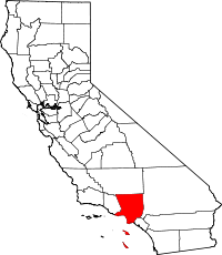
| County | Los Angeles | ||
| Incorporated | May 29, 1959 | ||
| Government | |||
| - Mayor | John C. Martins | ||
| - Mayor Pro Tem | Sally Zuniga Flowers | ||
| - City Council | Larry R. Nelson Tony Lima Victor Manalo |
||
| Area | |||
| - Total | 1.6 sq mi (4.2 km²) | ||
| - Land | 1.6 sq mi (4.2 km²) | ||
| - Water | 0.0 sq mi (0.0 km²) | ||
| Elevation | 52 ft (16 m) | ||
| Population (2000) | |||
| - Total | 16,380 | ||
| - Density | 10,126/sq mi (3,909.7/km²) | ||
| Time zone | PST (UTC-8) | ||
| - Summer (DST) | PDT (UTC-7) | ||
| ZIP codes | 90701-90703 | ||
| Area code(s) | 562 | ||
| FIPS code | 06-02896 | ||
| GNIS feature ID | 1660272 | ||
| Website: http://www.cityofartesia.us/ | |||
Artesia is a general law city in southeast Los Angeles County, California, United States and is one of the county's Gateway Cities. It was incorporated on May 29, 1959. The population was 16,380 at the 2000 census. Artesia is surrounded on the west, south, and east sides by Cerritos, with Norwalk to the north.
Artesia is the home of the East West Ice Palace, an ice rink which is co-owned by Michelle Kwan. It was also the childhood home (1914 until 1931) of former First Lady Pat Nixon, though the house in which she grew up is now part of neighboring Cerritos.
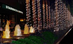
Although Artesia is best known for the "Little India" section of Pioneer Boulevard, there are also many Filipino, Mexican, Chinese, and Korean-owned stores and residences in the area, as well as Portuguese and other Caucasian-owned stores and residences.
Contents |
History
The village of Artesia was established upon the completion of the Artesia School District on May 3, 1875. It was named for the many flowing Artesian wells in the area, which made the village ideal for farming and agriculture.
In the 1920s and 1930s, Dutch and Portuguese farmers developed Artesia into one of the most important dairy districts in Southern California. After World War II, as with many other cities in the region, Artesia was pressured by developers to build residential tracts. The city of Dairy Valley was incorporated in 1956, and later became the city of Cerritos. As the demand for housing continued, dairymen moved their operations further east into Chino and north into the Central Valley. Artesia finally incorporated on May 29, 1959.
In 1993, the Artesia Historical Society was formed, with the mission of preserving and protecting the archives and historic sites of the city. In 2002, the Historical Society salvaged and restored one of the last remaining Spanish styled homes in the city into a historical civic museum open to the public. [1]
Artesia Water Tower

One of the more familiar landmarks in the city is the Artesia Water Tower. Not much is known about its active past or when it was constructed. The City of Artesia is currently trying to have the tower declared as a Historical Landmark and is asking its citizens for historical information and photos of the tower.
The water tower can hold 50,000 gallons of water and was once owned by the Southern California Water Company before being sold to the City of Artesia in 1988. The tower was intended to be used only as a point of historical interest, and to provide a special identity to the community. Shortly after its purchase, the then green tower was quickly painted to its current color with the addition of the name Artesia painted on two sides.
It sits on top of an artesian well in 1911, however, no record of its construction can be found. Although it may have once been a smaller wooden tower, to qualify for historic designation in California, factual documentation must be presented.
The Artesia Water Tower was also featured in the motion picture, Freddy's Dead: The Final Nightmare in 1991 and was known in the film as the Springwood Water Tower.[2]
It was also featured in an episode of My Name is Earl, in 2006.
Little India vs International and Cultural Shopping District

There is a large number of Indian-owned stores and restaurants along Pioneer Blvd. in Artesia. Despite this concentration of Indian-owned businesses, Asian Indians made up only 4.6% of the population of Artesia in the 2000 Census [3].
Proposals have often been made to designate a portion of the city as "Little India" (along the lines of Little Saigon in nearby Westminster and Garden Grove). Another proposal has been for a "Little India" sign at the Pioneer Blvd. exit off of the Artesia Freeway. Opposition, primarily from other ethnicities in the city, has so far stymied such plans.
According to the LA Times article, "Artesia Thinks the World of Itself," [4]four of five City Council members were outraged at Assemblyman Rudy Bermudez' attempt to make the designation without consulting the local council. The council members won a bill requiring local approval of proposed freeway sign designations. Then Mayor Larry Nelson said Indian Americans constituted less than 1% of the city's population and that East Asian markets outnumber Indian ones 3 to 1. Thus, the name is "International and Cultural Shopping District."
Geography
Artesia is located at (33.867215, -118.080622)[1].
According to the United States Census Bureau, the city has a total area of 4.2 km² (1.6 mi²), all land.
Demographics

As of the census[2] of 2000, there were 16,380 people, 4,470 households, and 3,625 families residing in the city. The population density was 3,903.9/km² (10,126.1/mi²). There were 4,598 housing units at an average density of 1,095.9/km² (2,842.5/mi²). The racial makeup of the city was 44.18% White, 3.55% Black or African American, 0.78% Native American, 27.41% Asian, 0.54% Pacific Islander, 18.47% from other races, and 5.07% from two or more races. 38.29% of the population was Hispanic or Latino of any race.
There were 4,470 households out of which 40.7% had children under the age of 18 living with them, 60.4% were married couples living together, 14.1% had a female householder with no husband present, and 18.9% were non-families. 15.3% of all households were made up of individuals and 6.7% had someone living alone who was 65 years of age or older. The average household size was 3.54 and the average family size was 3.87.
In the city the population was spread out with 27.2% under the age of 18, 10.1% from 18 to 24, 29.4% from 25 to 44, 21.0% from 45 to 64, and 12.4% who were 65 years of age or older. The median age was 34 years. For every 100 females there were 100.5 males. For every 100 females age 18 and over, there were 95.8 males.
The median income per household in the city was $44,500, and the median income per family was $47,017. Males had a median income of $34,447 versus $25,256 for females. The per capita income for the city was $15,763. About 8.7% of families and 11.5% of the population were below the poverty line, including 12.2% of those under age 18 and 7.4% of those age 65 or over.
Ancestry and ethnicity

45.8% of the residents of Artesia are foreign-born, and 25.2% are not US citizens.
For Europeans, 9.4% of Artesia is of Portuguese ancestry, with 49.4% of those foreign-born. Dutch is the second most commonly reported European ancestry at 4.6%. [5]
27.4% of Artesia is of Asian ancestry. The most commonly reported ancestries are Filipino 10.4%, Chinese 5.1%, Asian Indian 4.6%, and Korean 4.5%.
3.6% of Artesia is Black or African American. [6]
38.3% of Artesia is Hispanic or Latino, with most of those of Mexican descent (32.4%). [7]
Politics
In the state legislature Artesia is located in the 27th Senate District, represented by Democrat Alan Lowenthal, and in the 56th Assembly District, represented by Democrat Tony Mendoza. Federally, Artesia is located in California's 39th congressional district, which has a Cook PVI of D +13[3] and is represented by Democrat Linda Sánchez.
Emergency services
Fire protection in Artesia is provided by the Los Angeles County Fire Department with ambulance transport by Care Ambulance Service. The Los Angeles County Sheriff's Department provides law enforcement.
Education
Artesia residents are served by the ABC Unified School District.
Famous Residents
- Ed O'Bannon - UCLA basketball star, 1st round NBA draft pick
- Charles O'Bannon - Brother to Ed O'Bannon. UCLA basketball player
- Jason Kapono - UCLA basketball guard, 1st round NBA draft pick. Currently playing for the Toronto Raptors.
- Pat Nixon - Wife of late President Richard Nixon, grew up on a small farm in Artesia
External links
- Artesia official website
- LA County Disaster Communications Service (DCS) Lakewood Sheriff Station
- Gateway Cities website
- Artesia Chamber of Commerce
- Artesia Indian community guide
- Smithpublish.com/Artesia - The official source for Artesia news and information
- Artesia, California is at coordinates
References
- ↑ "US Gazetteer files: 2000 and 1990". United States Census Bureau (2005-05-03). Retrieved on 2008-01-31.
- ↑ "American FactFinder". United States Census Bureau. Retrieved on 2008-01-31.
- ↑ "Will Gerrymandered Districts Stem the Wave of Voter Unrest?". Campaign Legal Center Blog. Retrieved on 2008-02-10.
4. ^Artesia Thinks the World of Itself
|
|||||||||||||||||