Arequipa
| Arequipa | |||
|
|||
| Nickname(s): La Ciudad Blanca (The White City) | |||
 Arequipa
|
|||
| Coordinates: | |||
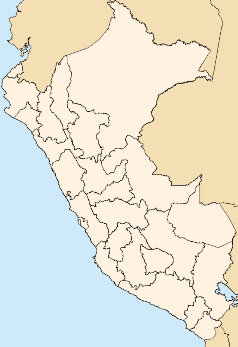
| Country | Peru | ||
|---|---|---|---|
| Region | Arequipa | ||
| Province | Arequipa | ||
| Established | 15 August 1540 | ||
| Government | |||
| - Mayor | Simón Balbuena Marroquín | ||
| Area | |||
| - City | 9,862.02 km² (3,807.7 sq mi) | ||
| - Metro | 2,923.53 km² (1,128.8 sq mi) | ||
| Elevation | 2,380 m (7,740 feet ft) | ||
| Population | |||
| - City | 1,006,781 | ||
| - Metro | 1,006,781 | ||
| - Metro Density | 280.23/km² (725.8/sq mi) | ||
| Time zone | PET (UTC-5) | ||
| - Summer (DST) | PET (UTC-5) | ||
| Area code(s) | 54 | ||
| Website: www.munarequipa.gob.pe | |||
Arequipa is the capital of the Arequipa Region in southern Peru. With a population of 749,291 it is the second most populous city of the country. Arequipa lies in the Andes mountains, at an altitude of 2,380 meters (7800 feet) above sea level; the snow-capped volcano El Misti overlooking the city. The city has many colonial-era Spanish buildings built of sillar, a pearly white volcanic rock, from which it gets the nickname La Ciudad Blanca ("The White City"). The historic centre of Arequipa was named a UNESCO world heritage site in 2000, in recognition of its architecture and historic integrity.
Contents |
Name
It is often said that the city's name comes from the Quechua phrase "Ari, quepay" which means "Yes, here" which is said to have been the response of the Fourth Inca - Mayta Capac - upon seeing the site of the great city, which was later destroyed in an earthquake, but reestablished by the Spanish in 1540. Nowadays it is assumed that the name derives from Aymara "ari" (peak) + "kipa" (locative) and means something like "near the mountain" in reference to the nearby El Misti Volcano, which towers 5822 meters above sea level.
Climate
Arequipa is dry and sunny all year long. During August, the weather gets slightly cold at night and at dawn, but the mornings and afternoons are warmed by bright sunshine. Generally speaking, the weather in Arequipa is mild with temperatures fluctuating between 10 and 24°C. The rainy season lasts from January to March but rainfall is reasonably moderate.
History

Archaeological findings indicate the fertile valley in which Arequipa is situated has been occupied back to 5000 – 6000 BCE. In the 15th century, the region, then occupied by Aymara Indians, was conquered by the Inca and served as an important supplier of agrarian products to the Inca Empire. The modern city of Arequipa was founded on 15 August, 1540, by Garcí Manuel de Carbajal, an emissary of Spanish conquistador Francisco Pizarro. Arequipas' first mayor was D. Juan de la Torre y Díaz Chacón, one of the most important conquistadores and founders of Peru.
One year later, King Charles V of Spain gave it the rank of 'city' and the coat of arms that it still bears. Spanish influence left many relics and colonial architecture, which reminds the visitor of the city's colonial past.
This led Arequipa to develop a large mestizo population as its demographics changed and grew over the centuries. Since the late 1940's, however, there has been a huge and increasing immigration from the Peruvian sierra, thus changing the demographic and cultural character of the city.

Throughout history Arequipa remained relatively isolated during colonial and early republican times, but that changed in 1870 when a Southern railroad to the coastal port of Mollendo was inaugurated, opening trade via the Pacific Ocean. The building and expansion of more roads in the 1930s also led to a direct connection with the Pan-American Highway, strengthening Arequipa's links to the rest of the Americas. Since then, the city has remained the center of commerce between Lima and all of southern Peru.
Arequipa served as a bastion of nationalism during Peru's struggle for independence from Spain in the early 19th century. Later, it served as a rallying point during the War of the Pacific (1879 – 1883) with Chile.
Villages from pre-Incan times are still in use today by many different farmers. Some of these farmers include those from the districts of Chilina, Socabaya, Paucarpata, Characato, and Sabandia.
Arequipa has experienced many earthquakes. It was almost destroyed by one in 1868, and on June 23, 2001, Arequipa was badly damaged by an earthquake of 7.9 on the Richter scale. In June 2002, Arequipa was completely paralyzed for a week by strikes and riots in protest of the privatization of two regional electricity-generating plants.
Education

The city has had many universities but the most recognized are — the Universidad Nacional de San Agustín de Arequipa, the local state university (founded 1828), the Universidad Católica de Santa María (founded in 1961), the Universidad católica de San pablo, and the Universidad Alas Peruanas. These are private institutions.
One of Peru's largest stadiums, Estadio Monumental de la UNSA, is also located in Arequipa and hosted some of the 2004 American Soccer Cup soccer games, attracting many tourists as well as locals.
Tourism
Founded as a colonial city, Arequipa is influenced by both Andalusian and Spanish colonial ideas and architecture. Popular and touristic sites include the 16th century Santa Catalina Monastery, the Goyeneche Palace, Casa del Moral, and the district of Yanahuara, a point of confluence for visitors seeking a view point of the urban geography of the city. Arequipa has many valuable archaeological and tourist resources including the Colca Canyon, one of the deepest in the world and an ideal spot for observing the magnificent Andean Condor.
Historic Centre

The Historic centre of Arequipa, built in volcanic sillar rock, represents an integration of European and native building techniques and characteristics, expressed in the admirable work of colonial masters and Criollo and Indian masons. This combination of influences is illustrated by the city's robust walls, archways and vaults, courtyards and open spaces, and the intricate Baroque decoration of its facades.
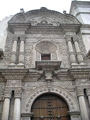
Santa Catalina monastery

Santa Catalina Monastery was founded on the second of October in 1580 and has an extension of 20000 square metres and was constructed in the second half of the XVIth Century. The Convent, in which there are still nuns living in cloisters, is a walled small city with narrow streets, passages, stair cases and small squares.
The Convent, a city in miniature closed to the public until 1970, combines the white colour of the sillar with other tonalities, like ochre, indigo and orange that go well with the otherwise austere style.
Society of Jesus Architectural Complex
Of impressive conventual aspect, it is the only edifice, which conserves the colonial art from its bases. It consists of two cloisters with portal led corridors made of carved sillar and Jesuitics monograms in the upper part. It is the purest sample of the mestizo Arequipa style.
which was built by the Jesuits in the XVIIth Century, makes an impression by its carved façade that was finished in 1698. Its pulpit in carved wood and its old sacristy, well-known as the so called Sixtine Chapel of Arequipa, was the fruit of the work of anonymous indigenous artists, who imprimed in the work their own colour, their own motives and their own spirit.
The temple presents a structure of two levels, typical of the European churches of the XVIth and XVIIth Centuries. Other architectonic details of interest are the half point vaults and the half columns that hold up the superior floor. Its interior is a display of luxury and ornamentación, with golden altars of Mestizo Baroque style, a beautiful pulpit from the XVIIth Century and more than 60 paintings of the Cusco School
The Founder's mansion
Built with sillar stone at the edge of a cliff, it is one of the most important and traditional mansions or houses in the department. According to the story, Garcí Manuel de Carbajal, founder of Arequipa, had it built for his son. Later, in 1785, Mr. Juan Crisóstomo de Goyeneche y Aguerreverre was its proprietor and remodeled it, giving it the distinguished characteristics that can be seen today. The main entrance is composed of a foyer with an arched ceiling, followed by a wide principal patio over which the windows and doors of the bedrooms open.
Transportation

Arequipa is served by the Rodríguez Ballón International Airport.
Sister cities
Notable people from Arequipa
- Ignacio Alvarez Thomas, Soldier who fought in the independence war in Argentina. Supreme Director of the Argentine Federation from 1815-1816.
- Ana de los Angeles Monteagudo, famous cloistered nun.
- Víctor Andrés Belaúnde, Lawyer, chaired two sessions of UN General Assembly
- Carlos Baca-Flor Soberón, Famous painter.
- José Bustamante y Rivero, President of Peru (1945-1948)
- Mario Cavagnaro, Prolific composer of Peruvian criollo music and boleros.
- Honorio Delgado, renowned Psychiatrist
- Pedro Diez Canseco, Two time President of Perú. He was previously Vice President both times
- Francisco García Calderón, President of Peru (1881)
- Julio Granda, Chess Grand Master
- Abimael Guzmán, founder and leader of Shining Path
- Madeleine Hartog Bell, Miss World titleholder in 1967.
- Alberto Hidalgo, Poet.
- Eduardo López de Romaña, President of Peru (1899-1903)
- Francisco Xavier de Luna Pizarro, Peruvian Priest and Politician; President of Peru during two brief occasions
- Julio Malaga Grenet, Famous caricaturist.
- Mariano Melgar, Poet, Independence fighter
- Vladimiro Montesinos, imprisoned head of the National Intelligence Service
- Alex Olmedo, Tennis Player, Ranked #1 in the world in 1959
- Pedro Paulet, Scientist, Peruvian engineer and statesman, The inventor of the liquid fuel motor (1895) and the first modern rocket propulsion system (1900)
- Mariano Felipe Paz Soldan, Peruvian historian and geographer
- Nicolás de Piérola, President of Peru (1879-1881) and from (1895-1899)
- Mariano Eduardo de Rivero y Ustariz, Most notable Peruvian scientist of the 19th century.
- Jose Said, Successful businessman founder of Parque Arauco S.A.
- Hernando de Soto, Renowned international economist
- Alberto Vargas, Painter, Noted for his famous Vargas Girls Collection
- Mario Vargas Llosa, Renowned writer
- Jorge Vinatea Reinoso, Painter.
- Juan Pablo Vizcardo y Guzman, Jesuit priest, Precursor of the Peruvian Independence
- Everardo Zapata Santillana, Educator. Author of the best seller book "Coquito" for children.
- Pedro Ximénez Abril y Tirado, Notable 19th-century composer of symphonies and concerts for violin and guitar.
See also
- 2001 southern Peru earthquake
- Arequipa region
- History of Peru
- Peruvian culture
- Spanish conquest of Peru
References
External links
- Arequipa travel guide from Wikitravel
- Local government of Arequipa
|
|||||
|
|||||
|
|||||||