Appalachian Trail
| Appalachian Trail | |
|---|---|
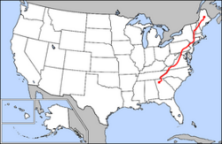 Map of Appalachian Trail |
|
| Length | approx. 2175 mi (3500 km)a[›] |
| Location | Eastern United States |
| Trailheads | Springer Mountain, Georgia Mount Katahdin, Maine |
| Use | Hiking |
| Elevation Change | 6401 ft (1951 m)[1] |
| Highest Point | Clingmans Dome |
| Lowest Point | Hudson River |
| Trail Difficulty | Moderate to Strenuous |
| Season | Spring to Fall |
| Sights | Appalachian Mountains |
| Hazards | Severe Weather American Black Bear Tick-borne diseases Mosquitos Biting flies Chiggers Steep Grades Limited Water Diarrhea From Water Poison Ivy Venomous Snakes |
The Appalachian National Scenic Trail, generally known as the Appalachian Trail or simply The A.T., is a marked hiking trail in the eastern United States, extending between Springer Mountain in Georgia and Katahdin in Maine.[2] It is approximately 2,175 miles (3,500 km)a[›] long. The path is maintained by thirty trail clubs and multiple partnerships.[3] The majority of the trail is in wilderness, although some portions do traverse towns and roads, and cross rivers.
The Appalachian Trail is famous for its many hikers, some of whom, called thru-hikers, attempt to hike it in its entirety in a single season. Earl Shaffer was the first to do so. Many books, memoirs, web sites and fan organizations are dedicated to this pursuit.
Along the way, the trail passes through the states of Georgia, North Carolina, Tennessee, Virginia, West Virginia, Maryland, Pennsylvania, New Jersey, New York, Connecticut, Massachusetts, Vermont, New Hampshire, and Maine. An extension, the International Appalachian Trail, continues north into Canada and to the end of the range, where it enters the North Atlantic Ocean.
The Appalachian Trail along with the Continental Divide Trail and the Pacific Crest Trail form the Triple Crown of long distance hiking in the United States.[4][5]
Contents |
History
The trail was conceived by Benton MacKaye, a forester who wrote his original plan shortly after the death of his wife in 1921. MacKaye's idea detailed a grand trail that would connect a series of farms and wilderness work/study camps for city-dwellers. In 1922, at the suggestion of Major William A. Welch, director of the Palisades Interstate Park Commission, his idea was publicized by Raymond H. Torrey with a story in the New York Evening Post under a full-page banner headline reading "A Great Trail from Maine to Georgia!" The idea was quickly adopted by the new Palisades Interstate Park Trail Conference as their main project.

On October 7, 1923, the first section of the trail, from Bear Mountain west through Harriman State Park to Arden, New York, was opened. MacKaye then called for a two-day Appalachian Trail conference to be held in March 1925 in Washington, D.C. This resulted in the formation of the Appalachian Trail Conference (now called the Appalachian Trail Conservancy), though little progress was made on the trail for several years.
At the end of the 1920s and beginning of the 1930s, a retired judge named Arthur Perkins and his younger associate Myron Avery took up the cause. Avery, who soon took over the ATC, adopted the more practical goal of building a simple hiking trail. He and MacKaye clashed over the ATC's response to a major commercial development along the trail's path; MacKaye left the organization, while Avery was willing to simply reroute the trail.
Avery became the first to walk the trail end-to-end, though not as a thru-hike, in 1936. In August 1937, the trail was completed to Sugarloaf Mountain in Maine, and the ATC shifted its focus toward protecting the trail lands and mapping the trail for hikers. From 1938 to the end of World War II, the trail suffered a series of natural and man-made setbacks. At the end of the war, the damage to the trail was repaired.
In 1948, Earl Shaffer of York, Pennsylvania, brought a great deal of attention to the project by completing the first documented thru-hike. (In 1994, a story appeared in the Appalachian Trailway News describing a 121-day Maine to Georgia thru-hike in 1936 by six Boy Scouts from the Bronx.[6] The story has been accepted by some individual members of ALDHA,[7] though a great deal of doubt has also been expressed;[8] this earlier thru-hike has never been verified or accepted by any responsible hiking organization or group; therefore, Shaffer's 1948 journey is still universally recognized as the first A.T. thru-hike.) Later, Shaffer also completed the first north-to-south thru-hike (all documented thru-hikes before that had been south-to-north).[9] In 1998 Mr. Shaffer, nearly 80 years old, again hiked the entirety of the trail, making him the oldest person ever to complete a thru-hike.[10]
In the 1960s, the ATC made progress toward protecting the trail from development, thanks to many sympathetic politicians and officials. The National Trails System Act of 1968 paved the way for a series of National Scenic Trails within the National Park and National Forest systems. Trail volunteers worked with the National Park Service to map a permanent route for the trail, and by 1971 a permanent route had been marked (though minor changes continue to this day). By the close of the 20th century, the Park Service had completed the purchase of all but a few miles of the trail's span.
Extensions
The International Appalachian Trail is a 690-mile (1,110 km) extension running north from Maine into New Brunswick and Quebec. It is a separate trail, not an official extension of the Appalachian Trail.[11] A further extension to Newfoundland is still under construction.
In 2008, the Pinhoti Trail in Alabama was connected to the southern terminus of the Appalachian Trail.
Flora and fauna
The Appalachian Trail is home to thousands of species of plants and animals, including 2,000 distinct rare, threatened, endangered, and sensitive plant and animal species.[3]
Animals

The American black bear (Ursus americanus) is the largest omnivore that may be encountered on the trail, and it inhabits all regions of the Appalachians.[12] However, bear sightings on the trail are uncommon, and confrontations rarer still, as black bears typically avoid humans and can usually be frightened away by loud noises. Other hazards include venomous snakes, including the Eastern timber rattlesnake and copperhead, which are common along the trail. Both snakes are generally found in drier, rockier sections of the trail; the copperhead's range extends north to around the New Jersey-New York state line, while rattlesnakes are commonly found along the trail in Connecticut and have been reported, although rarely, as far north as New Hampshire.[13] Other large fauna include deer; elk, reintroduced in the Smoky Mountains; and moose, which live as far south as Massachusetts but are more commonly seen in Maine.[13]

For most hikers, the most persistent pests along the trail are mice, which inhabit shelters, and bugs, which includes ticks, mosquitos, and black flies.
Plants
Plant life along the trail is varied. The trail passes through several different biomes from south to north, and the climate changes significantly, particularly dependent upon elevation. In the south, lowland forests consist mainly of second-growth; nearly the entire trail has been logged at one time or another. There are, however, a few old growth locations along the trail, such as Sages Ravine in Massachusetts and The Hermitage, near Gulf Hagas in Maine. In the south, the forest is dominated by hardwoods, including oak and tulip trees, also known as yellow poplar.[14] Further north, tulip trees are gradually replaced by maples and birches. Oaks begin to disappear in Massachusetts. By Vermont, the lowland forest is made up of maples, birch and beech, which provide spectacular foliage displays for hikers in September and October.[15] While the vast majority of lowland forest south of the White Mountains is hardwood, many areas have some coniferous trees as well, and in Maine, these often grow at low elevations.[14]
There is a drastic change between the lowland and subalpine, evergreen forest, as well as another, higher break, at treeline, above which only hardy alpine plants grow.[14] The sub-alpine region is far more prevalent along the trail than true alpine conditions. While it mainly exists in the north, a few mountains in the south have subalpine environments. These include the Great Smoky Mountains, where sub-alpine environments only begin around 6,000 feet (1,800 m) in elevation, the Unaka and Roan Ranges on the North Carolina-Tennessee border, where sub-alpine growth descends below 6,000 feet (1,800 m), and Mount Rogers and the Grayson Highlands in Virginia, where there is some alpine growth above 5,000 feet (1,500 m). Some high mountains in the south are also balds, due to fires or grazing in recent centuries, or perhaps due to thin, sandy soils. Several balds are sprouting trees, and on some, the National Forest service actually mows the grasses periodically in order to keep the bald open. Mostly in the mid summer to late fall.
Topography
No sub-alpine regions exist between Mount Rogers in Virginia and Mount Greylock in Massachusetts, mainly because the trail stays below 3,000 feet (910 m) from Shenandoah National Park in Virginia to Mount Greylock. Mount Greylock, however, has a large subalpine region, the only such forest in Massachusetts, extending down to 3,000 feet (910 m), which in the south would be far from the sub-alpine cutoff. This is especially low because Greylock is exposed to prevailing westerly winds, as its summit rises 1,000 feet (300 m) higher than any other peak in Massachusetts. Further north, several peaks in Vermont reach into the sub-alpine zone, the bottom of which steadily descends, so that by the White Mountains in New Hampshire, it often occurs well below 3,000 feet (910 m). At Mount Moosilauke, which reaches to 4,802 feet (1,464 m), the first alpine environment on the trail is reached, where only thin, sporadic flora is interspersed with bare rocks. Between the two regions is the krummholz region, where stunted trees grow with their branches oriented away from the winter's prevailing northwest wind, thus giving the appearance of flags (they are often called "flag trees"). This region resembles lowland terrain and covers hundreds of miles north in Canada. It also contains many endangered and threatened species. The trail has been rerouted over New Hampshire's Presidential Range so the Appalachian Mountain Club can protect certain plant life. The alpine cutoff in the Whites is generally between 4200 and 4,800 feet (1,500 m). Mountains traversed by the AT above treeline include Mount Moosilauke, several miles along the Franconia Range, and the Presidential Range. In the Presidentials, the trail climbs as high as 6288 feet (1917 m) on Mount Washington and spends about 13 miles (21 km) continuously above treeline, in the largest alpine environment in the United States east of the Rocky Mountains.
In Maine, the trail extends in to even harsher environments, and sub-alpine and alpine growth descends to lower elevations. Alpine growth in the state ranges from around 2,500 feet (760 m) in the Mahoosuc Range to below 1,000 feet (300 m) in parts of the 100-Mile Wilderness, where nearly every area higher than 1,000 feet (300 m) is evergreen forest. These forests include more species of evergreen, as well. In addition to the white pine, spruce and hemlock prevalent further south, Maine has many cedar trees along the trail. Near the northern terminus, there are even some tamarack, a coniferous, pine-needled deciduous tree, which provides displays of yellow in the late fall after the birches and maples have gone bare. The hemlocks in Maine are also notable, as the woolly adelgid, which has ravaged populations further south, has not come into the state yet, and may be unable to make it so far north due to the cold climate.
Maine also has several alpine regions. In addition to several areas of the Mahoosuc range, the Baldpates, and Old Blue in southern Maine have alpine characteristics despite elevations below 4,000 feet (1,200 m). Saddleback Mountain and Mount Bigelow, further north, each only extend a bit above 4,000 feet (1,200 m), but have long alpine areas, with no tree growth on the summits and unobstructed views on clear days. From Mount Bigelow, the trail extends for 150 miles (240 km) with only a small area of alpine growth around 3,500 feet (1,100 m) on the summit of White Cap Mountain. Mount Katahdin, the second largest alpine environment in the eastern United States, has several square miles of alpine area on the flat "table land" summit as well as the cliffs and aretes leading up to it. Treeline on Katahdin is only around 3,500 feet (1,100 m). This elevation in Massachusetts would barely be a sub-alpine region, and, south of Virginia, consists of lowland forest. This illustrates the drastic change in climate over 2,000 miles (3,200 km).
Hiking the trail
As the Appalachian Trail was explicitly designed to be hiked, it includes resources to facilitate hikers. Some are common to trails throughout North America, while some are unique to the Appalachian Trail. The trail is much more frequently hiked south to north (i.e. Georgia to Maine) than vice versa. Hikers typically begin in March or April and finish in late summer or early to late fall of that particular year. Many hikers will break down the mileage into halves or thirds, so that they can have the best weather, which typically occurs between May and September.
Throughout its length, the AT is marked by 2-by-6-inch (5-by-15-cm) white paint blazes. Side trails to shelters, viewpoints and parking areas use similarly-shaped blue blazes.
In past years, some sections of the trail also used metal diamond markers with the AT logo, few of which survive.
Lodging
The trail has more than 200 shelters and camp sites available for hikers. The shelters, sometimes called lean-tos (in Maine, Massachusetts, and Connecticut), huts (in Shenandoah National Park and the White Mountains in New Hampshire) or adirondack shelters, are generally open, three-walled structures with a wooden floor, although some shelters are much more complex in structure. Shelters are usually spaced a day's hike or less apart, most often near a water source (which may be dry) and with a privy. They generally have spaces for tent sites in the vicinity.[2]
Shelters are generally maintained by local volunteers. Almost all shelters have one or more pre-hung food hangers (generally consisting of a short nylon cord with an upside-down tuna can suspended halfway down its length) where hikers can hang their food bags to keep them out of the reach of rodents. In hiker lingo, these are sometimes called "mouse trapezes."[16]
In addition to official shelters, many persons offer their homes, places of business, or inns to accommodate AT hikers. One example is the Little Lyford Pond camps maintained by the Appalachian Mountain Club. Inns are more common in sections of the trail that coincide with national parks, most notably Virginia's Shenandoah National Park.[17]
Trail towns

The trail crosses many roads, thus providing ample opportunity for hikers to hitchhike into town for food and other supplies. Many trail towns are accustomed to hikers passing through, and thus many have hotels and hiker-oriented accommodations.[2] Some of the most well-known trail towns are Monson, Maine; Harpers Ferry, West Virginia; Damascus, Virginia; Hot Springs, North Carolina; Erwin, Tennessee; Duncannon, Pennsylvania; Port Clinton, Pennsylvania; and Hanover, New Hampshire. In the areas of the trail closer to trail towns, many hikers have experienced what is sometimes called "trail magic," or assistance from strangers through kind actions, gifts, and other forms of encouragement.[18] Trail magic is sometimes done anonymously.[19] In other instances, persons have provided food and cooked for hikers at a campsite.
Hazards
The Appalachian Trail is relatively safe. Most injuries or incidents are consistent with comparable outdoor activities. Most hazards are related to weather conditions, human error, plants, animals, diseases, and fellow humans encountered along the trail. [20]
Many animals live around the trail, with bears, snakes, and wild boars posing the greatest threat to human safety. Several rodent- and bug-borne illnesses are also a potential hazard. Ticks are carriers for Lyme disease, ehrlichiosis and other diseases, and are in higher abundance in northern states. Being thoroughly covered and wearing DEET can greatly reduce the chances of getting infected.
In scattered instances, foxes, raccoons, and other small animals may bite hikers, posing risk of rabies and other diseases. There has been one reported case (in 1993) of hantavirus (HPS), a rare but dangerous rodent-borne disease affecting the lungs. The afflicted hiker recovered and hiked the trail the following year.[20]

Plant life can create its own brand of problems. Poison ivy is common the length of the trail, and more plentiful in the South. Flare-ups can be treated with calamine lotion or Solarcaine.[2]
Drinking untreated surface water can cause diarrhea. Springs are less risky.[21][22] The various methods of water treatment are filtering, chemical disinfectants, a portable ultraviolet light device, and pasteurization or boiling.[23]
Hiking season of the trail generally starts in mid to late spring, when conditions are much more favorable in the South. However, this time may also be characterized by extreme heat, sometimes in excess of 100 °F (38 °C). Under such conditions, hydration is imperative. Light clothing and sunscreens are a must at high elevations and areas without foliage, even in relatively cool weather.[20]
Further north and at higher elevations, the weather can be intensely cold, characterized by low temperatures, strong winds, hail or snow storms and reduced visibility. Prolonged rain, though not typically life-threatening, can undermine stamina and ruin supplies. Typical electrical storm precautions should be followed.[24]
Violent crime, including murder, has occurred on the trail in a few instances. Most have been crimes by non-hikers who crossed paths relatively randomly with the AT hiker-victims. The official website of the Appalatian Trail Conservancy points out that the number of violent crimes is extremely low when compared against the number of people (3 to 4 million) who hike on the trail every year.[25]
Nine homicides have been documented on the trail since the first reported homicide in Georgia in 1974. In 1981, the issue of violence on the Appalachian Trail received national attention when Robert Mountford Jr. and Laura Susan Ramsay, both social workers in Ellsworth, Maine, were murdered by Randall Lee Smith.[26] The most recent homicides occurred in May 1996, when two women were abducted, bound and murdered near the trail in Shenandoah National Park. The primary suspect was later discovered harassing a female biker in the vicinity[27] but charges against him were dropped, and the case remains unsolved.[28]
On May 6, 2008, Randall Lee Smith, the killer of Mountford and Ramsay in 1981, shot two fisherman from Virginia near the trail in Giles County, Virginia, not far from the site of his 1981 murder; he then stole their pickup truck but crashed it and was imprisoned. The fishermen survived, but Smith died in jail four days later,[29] most likely from an acute pulmonary thromboembolism incurred when he crashed the pickup truck.[30]
Trail completion
Trail hikers who attempt to complete the entire trail in a single season are called "thru-hikers"; those who traverse the trail during a series of separate trips are known as "section-hikers". Rugged terrain and cold weather during the spring and fall make thru-hiking difficult. Traditionally, only about 10% to 15% of those who make the attempt report to the Appalachian Trail Conservancy that they completed it. However, since 2001, the number of people starting out in Georgia to do a thru-hike (or at least registering to do so) has dropped considerably, yet the number of people reporting that they have completed a thru-hike has remained approximately the same. This has resulted in an apparent increase in the completion rate to 29% (as of 2006). Considering that the rangers station at Amicalola Falls (the beginning of the 8.3-mile (13.4 km) approach trail to Springer Mountain) had changed its policy on hiker registration at about the same time, it is possible that the drop in thru-hikers starting out is only a perceived drop due to a change in reporting. As of 2007, the total number of reported thru-hike completions since the 1930s was 9,583.[1] It is widely acknowledged that many or even most of these have skipped portions of the Trail.[2] Completion generally requires five to seven months, although some have done it in three months, and several trail runners have completed the trail in less time. Trail runners typically tackle the AT with automobile support teams, without backpacks, and without camping in the woods.
The current unofficial speed record for through-hiking the AT was set by trail runner Andrew Thompson in 2005, at 47 days, 13 hours and 31 minutes. Thompson made the trip southbound, from late June to early August.[31]
Thru-hikers are classified into many informal groups. "Purists" are hikers who stick to the official AT trail except for side trips to shelters and camp sites. "Blue Blazers" cut miles from the full route by taking side trails marked by blue blazes. The generally pejorative name "Yellow Blazers," a reference to yellow road stripes, is given to those who hitchhike to move down the trail. There are also those who hike the trail in sections known as "sectioners" as opposed to those who hike the whole trail as one course.
Most thru-hikers walk northward from Georgia to Maine, and generally start out in early spring and follow the warm weather as it moves north.[2] These "north-bounders" are also called NOBO (NOrthBOund) or GAME (Georgia(GA)-to-Maine(ME)), while those heading in the opposite direction are termed "south-bounders" (also SOBO or MEGA).
Part of hiker subculture includes making colorful entries in logbooks at trail shelters, signed using trail names.
The Appalachian Trail Conservancy gives the name "2000 Miler" to anyone who completes the entire Trail. The ATC's recognition policy for "2000 Milers" gives equal recognition to thru-hikers and section-hikers, operates on the honor system, and recognizes blue-blazed trails or officially required roadwalks as substitutes for the official, white-blazed route during an emergency such as a flood, forest fire, or impending storm on an exposed, high-elevation stretch.[32]
Most of the trail is also open to local use.
Route
The trail is currently protected along more than 99% of its course by federal or state ownership of the land or by right-of-way. The trail is maintained by a variety of citizen organizations, environmental advocacy groups, governmental agencies and individuals. Annually, more than 4,000 volunteers contribute over 175,000 hours of effort on the Appalachian Trail, an effort coordinated largely by the Appalachian Trail Conservancy (ATC) organization.
In the course of its journey, the trail follows the ridgeline of the Appalachian Mountains, crossing many of its highest peaks, and running, with only a few exceptions, almost continuously through wilderness. The trail used to traverse many hundreds of miles of private property; currently 99% of the trail is on Public land. [33]

Georgia has 75 miles (120 km) of the trail,[34] including the southern terminus at Springer Mountain at an elevation of 3,280 feet (992 m). At 4,461 feet (1360 m), Blood Mountain is the highest point on the trail in Georgia. The AT and approach trail are managed and maintained by the Georgia Appalachian Trail Club. See also: Georgia Peaks on the Appalachian Trail.
North Carolina has 88 miles (142 km) of the trail,[35] not including more than 200 miles (325 km) along the Tennessee Border. Altitude ranges from 1,725 to 5,498 feet (525 m to 1676 m).
Tennessee has 293 miles (472 km) of the trail,[36] including more than 200 miles (325 km) along or near the North Carolina Border. The section that runs just below the summit of Clingmans Dome in Great Smoky Mountains National Park is the highest point on the trail at 6,625 feet (2019 m).

Virginia has 550 miles (885 km) of the trail,[37] including about 20 miles (32 km) along the West Virginia border. Some consider this to be the wettest, most challenging part of the hike for northbound hikers because of the spring thaw. On average, it rains 20 out of 30 days during the spring. Substantial portions closely parallel the Skyline Drive and the Blue Ridge Parkway in Shenandoah National Park. Parts of the trail near the Blue Ridge Parkway are often considered the best for beginner hikers. The trail goes within one half mile of the highest point in Virginia, Mt. Rogers, and is a short side-hike from the AT.[37]
West Virginia has 4 miles (6 km) of the trail,[38] not including about 20 miles (32 km) along the Virginia border. Here the trail passes through the town of Harpers Ferry, headquarters of the Appalachian Trail Conservancy. Harpers Ferry is considered the "psychological midpoint" of the AT.[39]
Maryland has 41 miles (66 km) of the trail,[40] with elevations ranging from 230 to 1,880 feet (70–570 m). This section, great for three- or four-day trips, is easy by AT standards, and is a good place for hikers to find out if they are ready for more rugged parts of the trail. Hikers are required to stay at designated shelters and campsites.
Pennsylvania has 229 miles (369 km) of the trail.[41] The trail extends from the Pennsylvania - Maryland line at Pen Mar, a tiny town straddling the state line, to the Delaware Water Gap, at the Pennsylvania - New Jersey border. The Susquehanna River is generally considered the dividing line between the northern and southern sections of the Pennsylvania AT, and Pine Grove Furnace State Park the halfway point.
The AT passes through St. Anthony's Wilderness, which is the second largest roadless area in Pennsylvania and home to several coal mining ghost towns, such as Yellow Springs and Rausch Gap.

New Jersey is home to 72 miles (116 km) of the trail.[42] The trail enters New Jersey from the south on a pedestrian walkway along the Interstate 80 bridge over the Delaware River, ascends from the Delaware Water Gap to the top of Kittatinny Ridge in Worthington State Forest, passes Sunfish Pond (right), continues through Stokes State Forest and eventually reaches High Point State Park, highest peak in New Jersey (a side trail is required to reach the actual peak). It then turns in a southeastern direction along the New York border for about 30 miles (48 km), passing over long sections of boardwalk bridges over marshy land, then entering Wawayanda State Park and then the Abraham Hewitt State Forest just before entering New York near Greenwood Lake.
Black bear activity along the trail in New Jersey increased rapidly starting in 2001. Hence, metal bear-proof trash boxes are in place at all New Jersey shelters.

New York's 88 miles (142 km) of trail[43] contain very little elevation change compared to other states. From south to north, the trail summits many small mountains under 1,400 feet (430 m) in elevation, its highest point in New York being Prospect Rock at 1,433 feet (438 m), and only 3,000 feet (800 m) from the border with New Jersey. The trail continues north, climbing near Fitzgerald Falls, passing through Sterling Forest, and then entering Harriman State Park and Bear Mountain State Park. It crosses the Hudson River on the Bear Mountain Bridge, the lowest point on the entire Appalachian Trail at 124 feet (38 m). It then passes through Fahnestock State Park, and continues northeast until it enters Connecticut via the Pawling Nature Reserve. The section of the trail that passes through Harriman and Bear Mountain State Parks is the oldest section of the trail, completed in 1923.
The 52 miles (84 km) of trail in Connecticut[44] lie almost entirely along the ridges to the west above the Housatonic River valley.
The state line is also the western boundary of a 480 acre (190 ha) Connecticut reservation inhabited by 11 Schaghticoke Indians. Inside it, the AT roughly parallels its northern boundary, crossing back outside it after 2,000 feet (640 m).

Massachusetts has 90 miles (145 km) of trail.[45] The entire section of trail is in western Massachusetts' Berkshire County. It summits the highest peak in the Southern Taconic Range, Mount Everett (2,602 ft., 793 m), then descends to the Housatonic River Valley and skirts the town of Great Barrington. The trail passes through the towns of Dalton and Cheshire, and summits the highest point in the state at 3,491 feet (1,064 m), Mount Greylock. It then quickly descends to the valley within 2 miles (3 km) of North Adams and Williamstown, before ascending again to the Vermont state line. The trail throughout Massachusetts is maintained by the Berkshire Chapter of the Appalachian Mountain Club.
Vermont has 150 miles (241 km) of the trail.[46] Upon entering Vermont, the trail coincides with the southernmost sections of the generally north/south-oriented Long Trail (which is subject to a request by its maintainers to protect it in its most vulnerable part of the year by forgoing spring hiking). It follows the ridge of the southern Green Mountains, summitting such notable peaks as Stratton Mountain, Glastenbury Mountain and Killington Peak. After parting ways with the Long Trail at Maine Junction, the AT turns in a more eastward direction, crossing the White River, passing through Norwich, and entering Hanover, New Hampshire, as it crosses the Connecticut River. The Green Mountain Club maintains the AT from the Massachusetts state border to Route 12. The Dartmouth Outing Club maintains the trail from Route 12 to the New Hampshire state line.

New Hampshire has 161 miles (259 km) of the trail.[47] The New Hampshire AT is nearly all within the White Mountain National Forest. For northbound thru-hikers, it is the beginning of the main challenges that go beyond enduring distance and time: in New Hampshire and Maine, rough or steep ground are more frequent and alpine conditions are found near summits and along ridges. The trail reaches more than half of the four-thousand footers of New Hampshire, including Mount Washington, the highest point of the AT north of Tennessee. The Dartmouth Outing Club maintains the AT from the Vermont border past Mount Moosilauke to Kinsman Notch, with the AMC maintaining the remaining miles through the state.

The 281 miles (452 km) of the trail in Maine are particularly difficult.[48] More moose are seen by hikers in this state than any other on the trail. The northern terminus of the Appalachian Trail is on Mount Katahdin's Baxter Peak in Baxter State Park.
The western section includes a mile-long (1.6 km) stretch of boulders at Mahoosuc Notch, often called the trail's hardest mile. Also, although there are dozens of river and stream fords on the Maine section of the trail, the Kennebec River is the only one on the trail that requires a boat crossing. The most isolated portion in the state (and arguably on the entire trail) is known as the "100-Mile Wilderness." This section heads east-northeast from the town of Monson and ends outside Baxter State Park just south of Abol Bridge.[48]
Park management strongly discourages thru-hiking within the park before May 15 or after October 15.[49]
The AMC maintains the AT from the New Hampshire border to Grafton Notch, with the Maine Appalachian Trail Club responsible for maintaining the remaining miles to Mt. Katahdin.
Further reading
ATC's official Appalachian Trail guide is the Thru-Hiker's Companion, compiled by volunteers of the Appalachian Long Distance Hikers Association (ALDHA) (available at AppalachianTrail.org). Also available from the ATC is the Official AT Databook, an annually updated compilation of trail mileages, water sources, road crossings, shelter locations, and other information. The 2007 DataBook is the 29th annual edition, and is considered indispensable by many AT hikers and hiking guides.[50] Also available through the ATC are individual state guidebooks and map sets. Another annual guide book to the AT, the Thru-Hiker's Handbook, was written by Dan "Wingfoot" Bruce since 1985 and was taken over by Bob "501" McCaw as of 2008.
Scores of books about the trail have been published by thru-hikers and others:
- The first thru-hiker, Earl Shaffer, wrote an account of his journey titled "Walking With Spring."
- Edward B. Garvey wrote "Appalachian Hiker" and "Appalachian Hiker II" in 1971 and 1978, respectively, telling the story of the trail and his thru-hike of it from April to October 1970.
- Larry Luxenberg published "Walking the Appalachian Trail," a collection of interviews with thru-hikers.
- Adrienne Hall's book, "A Journey North," published in 2001, discussed the particulars of being a female thru-hiker.
- Bill Irwin, a blind man, wrote about walking the entire AT with his guide dog, Orient, in "Blind Courage."
- In 1997, Lynn Setzer published "A Season on the Appalachian Trail," a collection of stories and comments from hikers who attempted a thru-hike in 1996. A second edition, published in 2001, included hikers' perspectives five years after completing (or abandoning) their hikes.
- Bill Bryson's 1998 novel A Walk in the Woods gives a humorous view of the trail from a less-than-fit person's perspective.
- Jeff Alt's 2000 book A Walk for Sunshine recounts the thru-hike Alt completed in 1998 to raise money for his brother's cancer treatment.
Notes
^ a: The exact length of the Appalachian Trail is not known, as periodic changes and maintenance to the trail alters the trail's length, making an exact figure difficult, if not impossible, to ascertain. (See Outdoors.org)
References
- ↑ "AT Essentials". Appalachian Trail Conservancy. Retrieved on 3 November 2008.
- ↑ 2.0 2.1 2.2 2.3 2.4 2.5 Gailey, Chris (2006). "Appalachian Trail FAQs" Outdoors.org (accessed September 14, 2006)
- ↑ 3.0 3.1 A.T. Essentials" AppalachianTrail.org (accessed September 12, 2006)
- ↑ "Nimblewill Nomad Receives Triple Crown Award". International Appalachian Trail. Retrieved on 27 November 2008.
- ↑ Adams, Glenn (October 27, 2001). "Hiker Achieves 'Triple Crown'". Washington Post. Retrieved on 2008-11-27.
- ↑ [at-l] ATN article, 1936 Scout Hike
- ↑ http://www.aldha.org/newsletr/sum00.pdf
- ↑ http://www.appalachiantrail.org/atf/cf/%7BD25B4747-42A3-4302-8D48-EF35C0B0D9F1%7D/ATN00Nov.pdf, p. 4
- ↑ Earl V. Shaffer (2004), Walking With Spring, ISBN 0917953843
- ↑ Martin, Douglas (May 12, 2002). "Earl Shaffer, First to Hike Length of Appalachian Trail in Both Directions, Dies at 83" (in English). NY Times. Retrieved on 2008-11-16.
- ↑ Hughes, C.J. (September 27, 2002), "After 2,169 Miles, What's Another 690?". New York Times. 152 (52254):F1
- ↑ Wingfoot "Black Bears on the Appalachian Trail" TrailPlace.com (accessed September 14, 2006)
- ↑ 13.0 13.1 Appalachian Trail Conservancy Wildlife FAQ
- ↑ 14.0 14.1 14.2 Appalachian Trail Conservancy Plant FAQ
- ↑ Stroh, Bess Zarafonitis (September/October 1998), "Colorful climbs". National Parks. 72 (9/10):34-37
- ↑ Kimberly (2005). "Glossary of Terms" AdventureMatters.com (accessed September 12, 2006)
- ↑ "Cabins, Huts, and Hostels" AppalachianTrail.org (accessed September 12, 2006)
- ↑ Berger, Karen. "Appalachian Trail: Trail Magic" Gorp.com (accessed April 30, 2007)
- ↑ A.T. History Kodak.com (accessed April 30, 2007)
- ↑ 20.0 20.1 20.2 "Health and Safety" AppalachianTrail.org (accessed September 15, 2006)
- ↑ Boulware DR, Forgey WW, Martin WJ 2nd (2003). "Medical Risks of Wilderness Hiking". Am J Med 114 (4): 288–93. PMID 12681456.
- ↑ Boulware DR (2004). "Influence of Hygiene on Gastrointestinal Illness Among Wilderness Backpackers". J Travel Med 11 (1): 27–33. PMID 14769284.
- ↑ Backer, Howard D. (2007). "Chapter 61: Field Water Disinfection". Wilderness Medicine (5th edition). Ed. Paul S. Auerbach. Philadelphia, PA: Mosby Elsevier. 1368–417.
- ↑ "Weather" AppalachianTrail.org (accessed September 14, 2006)
- ↑ "2,000-Milers: Facts and Statistics". Appalachian Trail Conservancy. Retrieved on 30 October 2008.
- ↑ Haygood, Wil. "Blood on the Mountain". The Washington Post date=8 June 2008. Retrieved on 30 October 2008.
- ↑ "Trail Murders" Appalachian Long Distance Hikers Association website (accessed September 14, 2006)
- ↑ Nordin, Barbara (2004). "After Rice: New questions in Park murders" ReadTheHook.com (accessed September 14, 2006)
- ↑ Mallory, Anna (11 May 2008). "Suspect in AT shootings reported dead". The Roanoke Times. Retrieved on 30 October 2008.
- ↑ Morrison, Shawna (8 August 2008). "Suspect's death ruled accidental". The Roanoke Times. Retrieved on 30 October 2008.
- ↑ Jonathan Van Fleet (2005-08-05). "Hiker takes record in stride", Nashua Telegraph. Retrieved on 2007-10-08.
- ↑ "What Happens When I Finish?" AppalachianTrail.org (accessed September 11, 2006)
- ↑ "History" AppalachianTrail.org (accessed June 24, 2008).
- ↑ "Explore the Trail: Georgia" AppalachianTrail.org (accessed September 11, 2006).
- ↑ "Explore the Trail: North Carolina" AppalachianTrail.org (accessed September 11, 2006).
- ↑ "Explore the Trail: Tennessee" AppalachianTrail.org (accessed September 11, 2006).
- ↑ 37.0 37.1 "Explore the Trail: Virginia" AppalachianTrail.org (accessed September 11, 2006).
- ↑ "Explore the Trail: West Virginia" AppalachianTrail.org (accessed September 11, 2006).
- ↑ Coupland, David (2004). "Appalachian Adventure" Couplands.net (accessed September 12, 2006)
- ↑ "Explore the Trail: Maryland" AppalachianTrail.org (accessed September 11, 2006).
- ↑ "Explore the Trail: Pennsylvania" AppalachianTrail.org (accessed September 11, 2006).
- ↑ "Explore the Trail: New Jersey" AppalachianTrail.org (accessed September 11, 2006).
- ↑ "Explore the Trail: New York" AppalachianTrail.org (accessed September 11, 2006).
- ↑ "Explore the Trail: Connecticut" AppalachianTrail.org (accessed September 11, 2006).
- ↑ "Explore the Trail: Massachusetts" AppalachianTrail.org (accessed September 11, 2006).
- ↑ "Explore the Trail: Vermont" AppalachianTrail.org (accessed September 11, 2006).
- ↑ "Explore the Trail: New Hampshire" AppalachianTrail.org (accessed September 11, 2006).
- ↑ 48.0 48.1 "Explore the Trail: Maine" AppalachianTrail.org (accessed September 11, 2006).
- ↑ "Thru-Hiking in Baxter State Park" BaxterStateParkAuthoriy.com (accessed September 11, 2006)
- ↑ "Appalachian Trail Guidebooks for the thru hiker." Backpack45.com (accessed January 28, 2007).
See also
- Appalachian Development Highway System (ADHS) (in the eastern US)
- Eustace Conway
- List of counties that the Appalachian trail passes through
- International Appalachian Trail
Other long distance trails in the U.S.
- Pacific Crest Trail
- Continental Divide Trail
External links
Official sites
- Official site of the Appalachian Trail Conservancy
- National Park Service Trail information, with maps
- Georgia Appalachian Trail Club
- Maine Appalachian Trail Club
- Appalachian Trail in Virginia
- Potomac Appalachian Trail Club, for Virginia, Maryland, West Virginia, Pennsylvania, and the District of Columbia
Unofficial sites and hiking guides
- Appalachian Trail travel guide from Wikitravel
- Whiteblaze.net
- Backcountry.net - AT Mailing lists and archives
- The Official Kennebec River Free Canoe Ferry Service
- Google Map of AT with shelters
- Appalachian Trail Shelters - GPS data and maps
- Trail Journals
- Appalachia Long-Distance Hiking Association
- Google Earth Map of over 300 waypoints on Appalachian Trail
- Google AT Map Interactive AT map
|
|||||||

|
|||||||
|
|||||||
|
|||||||||||
|
||||||||||||||||||||
|
||||||||||||||||||||||||||||||||
|
|||||||||||||||||