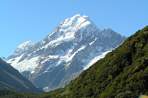
Aoraki/Mount Cook
| Aoraki/Mount Cook | |
|---|---|
 |
|
 Aoraki/Mount Cook
|
|
| Elevation | 3,754 metres (12,316 ft)[1] |
| Location | South Island, |
| Range | Southern Alps |
| Prominence | 3,754 metres (12,316 ft) |
| Coordinates | |
| First ascent | 1894 by Tom Fyfe, George Graham, Jack Clarke |
| Easiest route | glacier/snow/ice climb |
| Listing | Country high point Ultra 1 in New Zealand 37 in world by prominence |

Aoraki/Mount Cook is the highest mountain in New Zealand.[1] It lies in the Southern Alps, the mountain range which runs the length of the South Island. A popular tourist destination[2], it is also a favourite challenge for mountain climbers. Aoraki/Mt Cook consists of three summits lying slightly south and east of the main divide, the Low Peak, Middle Peak and High Peak, with the Tasman Glacier to the east and the Hooker Glacier to the west.
Contents |
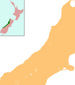
Location
The mountain is in the Aoraki/Mount Cook National Park. The park was formally declared in 1953, and in combination with Westland National Park is one of the United Nations World Heritage Parks. The park contains more than 140 peaks standing over 2,000 m (6,500 ft) and 72 named glaciers, which cover 40% of the park's 700 km² (173,000 acres).
The settlement of Mount Cook Village (also known as The Hermitage) is a tourist centre and base camp for the mountain. It is 7 km from the end of the Tasman Glacier, 12 km south of Aoraki/Mount Cook's summit.
Naming and European discovery

Aoraki means "Cloud Piercer" in the Ngāi Tahu dialect of the Māori language. Historically, the Māori name has been spelt Aorangi in the "canonical" Māori form. [3]
The first European known to see Aoraki/Mount Cook was Abel Tasman,[3] on December 13, 1642 during his first Pacific voyage. The English name of Mount Cook was given by Captain John Lort Stokes[1] to honour Captain James Cook who first surveyed and circumnavigated the islands of New Zealand in 1770. Captain Cook did not sight the mountain during his exploration[4].
Following the settlement between Ngāi Tahu and the Crown in 1998, the name of the mountain was officially changed from Mount Cook to Aoraki/Mount Cook to incorporate its historic Māori name, Aoraki[5]. As part of the settlement, a number of South Island placenames were amended to incorporate their original Māori name. Signifying the importance of Aoraki/Mount Cook, it is the only one of these names where the Māori name precedes the English. Under the settlement the Crown agreed to return title to Aoraki/Mount Cook to Ngāi Tahu, who then formally gifted it back to the nation.
Geology

The Southern Alps on the South Island are formed by tectonic uplifting and pressure as the Pacific and Australia-Indian plates collide along the island's western coast. The uplifting continues, raising Aoraki/Mount Cook an average of 7 mm (just over a quarter of an inch) each year. However, erosive forces are also powerful shapers of the mountains. The severe weather is due to the mountain's jutting into powerful westerly winds of the Roaring Forties which run around approximately 45°S latitude, south of both Africa and Australia. The Southern Alps are the first obstacle the winds encounter after South America as they blow easterly across the Southern Ocean.
Aoraki/Mount Cook was 10 m (33 ft) higher until approximately 10 million cubic metres of rock and ice fell off the northern peak on 14 December 1991[6][7].
Climbing

First attempt
The first recorded European attempt on the summit was made by the Irishman Rev. W. S. Green and the Swiss hotelier Emil Boss and the Swiss mountain guide Ulrich Kaufman on 2 March 1882[8]. but it was subsequently established that they were 50 m short of the true summit.
First ascent
On 25 December 1894 New Zealanders Tom Fyfe, James (Jack) Clarke and George Graham, successfully reached the summit via the Hooker Valley and the north ridge.[9] Swiss guide Matthias Zurbriggen climbed the mountain solo very shortly afterwards from the Tasman Glacier side, via the ridge that now bears his name. Local guide George Bannister, a descendant of Te Koeti Turanga of Ngāi Tahu was the first Maori to successfully scale the peak in 1912.[10]
It remains a challenging ascent, with frequent storms and very steep snow and ice climbing to reach the peak. Strictly speaking, it is a triple peak, with the north peak being the highest. A traverse of the three peaks was first accomplished in 1913 by Freda du Faur and guides Peter and Alex Graham. Three years earlier du Faur was the first woman to ascend Aoraki/Mount Cook.
Forests and glaciers
The average annual rainfall in the surrounding lowlands is around 7.6 m (300 inches). This very high rainfall leads to temperate rain forests in the coastal lowlands and a reliable source of snow in the mountains to keep the glaciers flowing. These include the Tasman and Murchison Glaciers to the east and the smaller Hooker and Mueller Glaciers to the south.
Area history

- 1642 - Aoraki sighted by Abel Tasman - Māori knew it for centuries before this.
- 1770 - Captain Cook named the Southern Alps
- 1851 - Captain Stokes of the survey ship HMS Acheron gave the name Mt Cook to Aoraki[1].
- 1884 - First Hermitage built under the direction of Frank Huddleson
- 1894 - First ascent of Aoraki/Mount Cook, on Christmas Day, by Jack Clarke, Tom Fyfe and George Graham
- 1910 - Freda du Faur became the first woman to climb Aoraki/Mount Cook
- 1911 - The vital swing bridge is built in the Hooker Valley
- 1913 - First ascents of the footstool and Mt Sefton made by Freda du Faur's climbing party
- 1913 - Hermitage first ravaged by floods in January, then destroyed beyond repair by floods two months later
- 1914 - First fatal accident, when three men caught in avalanche on Linda Glacier
- 1914 - Second Hermitage opened, on different site
- 1957 - Second Hermitage razed to the ground
- 1959 - First school opens, Aoraki Mt Cook School
- 1981 - Passenger flights begin by Mount Cook Airline, now part of Air New Zealand Link
- 1982 - Mark Inglis trapped in Schrund
- 1991 - Avalanche of 10 million cubic metres of snow and rock causes 10 metres to be lost off the top of Aoraki/Mount Cook[6][7]
- 1998 - The Ngāi Tahu Claims Settlement Act officially recognises the original name, renaming the mountain Aoraki/Mt Cook.[5]
References
- ↑ 1.0 1.1 1.2 1.3 "Aoraki/Mount Cook: Canterbury places to visit". Department of Conservation. Retrieved on 2007-05-08.
- ↑ "Aoraki/Mount Cook National Park Management Plan 2004" (PDF). Department of Conservation. Retrieved on 2007-05-09.
- ↑ 3.0 3.1 Te Maire Tau (2006-12-21). "Ngāi Tahu - Aoraki - Te Ara Encyclopedia of New Zealand". Ministry for Culture and Heritage / Te Manatū Taonga. Retrieved on 2007-05-08.
- ↑ James Cook (1728-1779). "Captain Cook's Journal During the First Voyage Round the World" Sunday, March 18, 1770. Retrieved on 2007-05-09.
- ↑ 5.0 5.1 "NZ Government Executive Ngai Tahu Settlement". New Zealand Government Executive. Retrieved on 2007-05-08.
- ↑ 6.0 6.1 Michael J. Crozier. "Mt Cook landslide". Te Ara - the Encyclopedia of New Zealand. Retrieved on 2007-05-03.
- ↑ 7.0 7.1 T. J. Chinn; M. J. McSaveney (1992). "Mount Aoraki (Mount Cook) rock avalanche". Tai Awatea - Knowledge Net (More of Te Papa online). Retrieved on 2007-05-03.
- ↑ Green, Reverend William Spotswood (1883). The High Alps of New Zealand, or A Trip to the Glaciers of The Antipodes with an Ascent of Mount Cook.
- ↑ Haynes, J. (1994) Piercing the Clouds. Tom Fyffe: First to climb Mt Cook. Hazard Press, New Zealand, ISBN 0-908790-64-3.
- ↑ Mountaineering - Guided climbing - Te Ara Encyclopedia of New Zealand
See also
- List of mountains of New Zealand by height