Aomori Prefecture
| Aomori Prefecture | |||||||||
|
|||||||||
 |
|||||||||
| Capital | Aomori (city) | ||||||||
| Region | Tōhoku | ||||||||
| Island | Honshū | ||||||||
| Governor | Shingo Mimura | ||||||||
| Area (rank) | 9,606.26 km² (8th) | ||||||||
| - % water | 1.2% | ||||||||
| Population (October 1, 2000) | |||||||||
| - Population | 1,475,728 (28th) | ||||||||
| - Density | 154 /km² | ||||||||
| Districts | 8 | ||||||||
| Municipalities | 40 | ||||||||
| ISO 3166-2 | JP-02 | ||||||||
| Website | http://www.pref.aomori.lg.jp/en/ | ||||||||
| Prefectural Symbols | |||||||||
| - Flower | Apple blossom (Malus domestica) | ||||||||
| - Tree | Hiba (Thujopsis dolabrata) | ||||||||
| - Bird | Bewick's Swan (Cygnus bewickii) | ||||||||
Symbol of Aomori Prefecture |
|||||||||
| Template ■ Discussion ■ Parameter ■ WikiProject Japan | |||||||||
Aomori Prefecture (青森県 Aomori-ken?) is a prefecture of Japan located in the Tōhoku Region. The capital is the city of Aomori.
Contents |
History
The Aomori Prefecture came into existence in 1871. Aomori Town was established in 1889. The town was incorporated as a city in 1898 with a population of 28,000.
Around one o'clock in the afternoon of May 3, 1910 a fire broke out in the Yasukata district. Fanned by strong winds, in four short hours the fire devastated the whole city. The conflagration claimed 26 lives and injured a further 160 residents. It destroyed 5,246 houses and burnt 19 storage sheds and 157 warehouses.
At 10:30 p.m. on July 28, 1945 a squadron of American B29 bombers approached Aomori from the west and, in less than two hours bombed over 90% of the city.
Radio Aomori (RAB) made its first broadcast in 1951. Four years later, the first fish auctions were held. 1958 saw the completion of the Municipal Fish Market as well as the opening of the Citizen's Hospital. In the same year, the Tsugaru Line established a rail connection with Minmaya Village at the tip of the peninsula.
Meanwhile, various outlying towns and villages were being incorporated into the growing city and with the absorption of Nonai Village in 1962, Aomori became the largest city in the prefecture.
In March 1985, after 23 years of unremitting labor and an enormous financial investment of 700 billion yen, the Seikan Tunnel finally linked the islands of Honshū and Hokkaidō, thereby becoming the longest tunnel of its kind in the world. Almost exactly three years later, on March 13, railroad service was inaugurated on the Tsugaru Kaikyo Line.
That same day saw the end of the Seikan Ferry service, thus closing a chapter of history which began in 1908. During their 80 years of service, the familiar ferries of the Seikan line sailed between Aomori and Hakodate some 720,000 times, carrying 160 million passengers.
In April 1993, the enthusiasm of Aomori City and a group of six other local communities was rewarded with the opening of Aomori Public College.
In August 1994, Aomori City penned an "Education, Culture and Friendship Exchange Pact" with Kecskemet in Hungary. One year later a similar treaty was signed with Pyongtaek City in South Korea, and cultural exchange activities began with exchanges of woodblock prints and paintings.
Also, in April 1995, Aomori Airport became the first airport in the northern Tohoku region to offer regular international air service to Seoul, South Korea, and Khabarovsk, Russia.[1]
In June 2007, four North Korean defectors reached Aomori Prefecture, after having been at sea for six days, marking the second known case ever where defectors have successfully reached Japan by boat.[2]
Geography
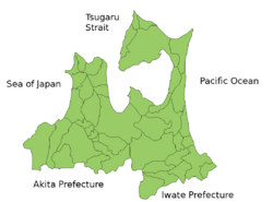
Aomori Prefecture is the northernmost prefecture on Honshū and faces Hokkaidō across the Tsugaru Strait. It borders Akita and Iwate in the south. Oma, at the northwestern tip of the axe-shaped Shimokita Peninsula, is the northernmost point of Honshū. The Shimokita and Tsugaru Peninsulas enclose Mutsu Bay. Between those peninsulas lies the Natsudomari Peninsula, the northern end of the Ōu Mountains. The three peninsulas are prominently visible in the prefecture's symbol, a stylized map.
Lake Towada, a crater lake, straddles Aomori's boundary with Akita.
Cities
Ten cities are located in Aomori Prefecture:
|
|
Towns and villages


These are the towns and villages in each district.
|
|
|
Mergers
Economy
Like much of Tōhoku, the Aomori region remains dominated by traditional industries such as farming, forestry, and fishing.
Demographics
Many young people depart Aomori for cities such as Tokyo or Sendai, looking for jobs and entertainment. Aomori records its population as having peaked in 1983.
Culture
Aomori is well known for its tradition of Tsugaru-jamisen, a virtuosic style of shamisen playing.
Transportation
Airports
- Aomori Airport
- Misawa Airport
Railway
- Stations
- Aomori Station, Hachinohe Station and Hirosaki Station
- Lines
- East Japan Railway Company
- Tōhoku Shinkansen
- Tōhoku Main Line
- Ōu Main Line
- Ōminato Line
- Gonō Line
- Hachinohe Line
- Tsugaru Line
- East Japan Railway Company
Tourism attractions

Aomori is especially famous for its apple orchards.
Lake Towada, a beautiful caldera, lies on the boundary between Akita and Aomori Prefectures. The Oirase river drains Lake Towada; in the summer it is refreshing and in the autumn the leaves are breathtaking.
Mount Osore, the Mountain of Dread, is near Mutsu on the Shimokita Peninsula.
The Hakkoda Mountains in Aomori provide excellent hiking in the warmer seasons. However, the winter proved disastrous to 199 of 210 soldiers who died during a military maneuver in the area in deep snow.
- Asupamu
- Hakkoda Ship
- Aomori Bay Bridge
- Munakata Shiko Memorial Museum of Art
- Aomori City Forestry Museum
- Aomori Prefectural Folk Museum
- Aomori City History and Folk Arts Museum
- Nebuta-no-sato Museum
- Mount Hakkoda
- Oirase Mountain Stream
- Sannai-Maruyama site
- Shirakami-Sanchi
There is a localized Japanese legend that Jesus Christ did not die on the cross but made his way to Shingo, Aomori where he became a rice farmer, married, and had a family [1]. The legend owes its existence to a supposed 1930s discovery, "the discovery of what were claimed to be ancient Hebrew documents detailing Jesus' life and death in Japan" [2]; the local legend also posits that his grave is located in Aomori.
Prefectural symbols
The Aomori prefectural symbol is a stylized map of the prefecture, showing the crown of Honshū: the Tsugaru, Natsudomari and Shimokita Peninsulas.
Miscellaneous topics
The two major dialects of Japanese spoken in Aomori Prefecture are Tsugaru-ben (津軽弁) and Nambu-ben (南部弁); the former is prevalent in the area around Aomori City, and the latter is heard in and around the city of Hachinohe.
Media
TV
- Aomori Broadcasting Corporation(RAB)
- Aomori Television(ATV)
- Asahi Broadcasting Aomori(ABA)
References
- ↑ Aomori City Homepage - The Story of Aomori. Retrieved on 7 June 2007
- ↑ "4 North Korean defectors reach Japan after 6 days on the open sea" Japan News Review (3 June 2007). Retrieved on 19 July 2008
External links
- Official Aomori Prefecture website (English)
- Aomori prefecture travel guide from Wikitravel
|
|||
| Cities | |||
|---|---|---|---|
| Aomori (capital) | Goshogawara | Hachinohe | Hirakawa | Hirosaki | Kuroishi | Misawa | Mutsu | Towada | Tsugaru | |||
| Districts | |||
| Higashitsugaru | Kamikita | Kitatsugaru | Minamitsugaru | Nakatsugaru | Nishitsugaru | Sannohe | Shimokita | |||
|
|
|||||||||||