Antalya
| Antalya | |||
 |
|||
|
|||
 Antalya
|
|||
| Coordinates: | |||
| Country | |||
|---|---|---|---|
| Region | Mediterranean | ||
| Province | Antalya | ||
| Government | |||
| - Mayor | Menderes Mehmet Tevfik Türel (Justice and Development Party) | ||
| Area | |||
| - Total | 1,417 km² (547.1 sq mi) | ||
| Elevation | 30 m (98 ft) | ||
| Population (2007)[1] | |||
| - Total | 775,157 | ||
| - Density | 478/km² (1,238/sq mi) | ||
| Time zone | EET (UTC+2) | ||
| - Summer (DST) | EEST (UTC+3) | ||
| Postal code | 07x xx | ||
| Area code(s) | 0242 | ||
| Licence plate | 07 | ||
| Website: http://www.antalya-bld.gov.tr/en | |||
Antalya (formerly known as Adalia; from Pamphylian Greek: Αττάλεια Attália) is a city on the Mediterranean coast of southwestern Turkey. It is the capital city of Antalya Province. The population of the city was 775157 in the 2007 census. Antalya has a Mediterranean climate. Situated on a cliff over the Mediterranean, Antalya is surrounded by mountains. Developments in tourism, starting in the 1970s, transformed the city into an international resort.
Contents |
History


See Antalya Province#History for the history of this area in antiquity
It is unknown when the site of the future city was first inhabited. Excavations in 2008 in the Doğu Garajı district of Antalya have uncovered remains dating to the third century, B.C, suggesting that the city was founded earlier than when Attalos II, king of Pergamon, believed to be the founder of the city, named it Attalia (present day Antalya) around 150 B.C. and chose it to be a naval base for his powerful fleet. Later Antalya became part of the Roman Republic in 133 BC when King Attalos III of Pergamum willed his kingdom to Rome at his death and the city grew and prospered in the Ancient Roman period. Christianity started to spread in the region after 2nd century. Antalya was visited by Paul of Tarsus, as recorded in the Acts of the Apostles (Acts 14:25-26), wherein Antalya is referred to by its ancient name, Attalia. From Perga, Paul and Barnabas went down to Attalia and sailed from there to Antioch after preaching in Pisidia and Pamphylia. The city later became a naval base for the Christian Crusades against the Muslims in the Levant and in Cyprus.
It was a major city in the Byzantine Empire. It was the capital of the Byzantine Theme of Carabisiani (Θέμα Kαραβησιάνων, Thema Karavēsianōn), which occupied the southern coasts of Asia Minor and the Aegean Islands. At the time of the accession of John II Comnenus (1118) it was an isolated outpost against the Turks, accessible only by sea.[2] The following year, with the aid of his commander-in-chief John Axuch, John II drove the Turks from the land routes to Antalya and reconnected the city with the rest of the empire.
The city, along with the whole region, was conquered by the Seljuk Turks in the early 13th century. Antalya was again the capital of the Turkish beylik of Teke between 1321-1423 until its conquest by the Ottomans. The Arabic traveler Ibn Battuta who came to the city in between 1335-1340 noted:
| “ | From Alanya I went to Antaliya [Adalia], a most beautiful city. It covers an immense area, and though of vast bulk is one of the most attractive towns to be seen anywhere, besides being exceedingly populous and well laid out. Each section of the inhabitants lives in a separate quarter. The Christian merchants live in a quarter of the town known as the Mina [the Port], and are surrounded by a wall, the gates of which are shut upon them from without at night and during the Friday service. The Greeks, who were its former inhabitants, live by themselves in another quarter, the Jews in another, and the king and his court and Mamluks in another, each of these quarters being walled off likewise. The rest of the Muslims live in the main city. Round the whole town and all the quarters mentioned there is another great wall. The town contains orchards and produces fine fruits, including an admirable kind of apricot, called by them Qamar ad-Din, which has a sweet almond in its kernel. This fruit is dried and exported to Egypt, where it is regarded as a great luxury.[3] | ” |

By the second half of the 17th century Evliya Çelebi recorded a city of narrow streets containing 3,000 houses in twenty Turkish neighbourhoods and four Greek. The town had grown beyond the city walls and the port could hold up to 200 boats.
In the 18th century, in common with most of Anatolia, its actual lord was from the Dere Bey family. The family of Tekke Oglu, domiciled near Perge, though reduced to submission in 1812 by Mahmud II, continued to be a rival power to the Ottoman governor till within the present generation, surviving by many years the fall of the other great Beys of Anatolia. The records of the Levant (Turkey) Company, which maintained an agency here till 1825, contain information as to the local Dere Beys.
In the 19th century the population of Antalya increased as Turks from the Caucasus and the Balkans moved into Anatolia. By 1911 it was a city of about 25,000 people, including many Christians and Jews, still living in separate quarters, round the walled mina or port. The port was served by coasting steamers of the local companies only. Antalya (then Adalia) was picturesque, but ill-built and backward. The chief attraction for visitors to see was the city wall, outside which ran a promenade and which survives to this day. The government offices and the houses of the better class were all outside the walls.[4]
The city was briefly occupied by the Italians from the end of the First World War until the founding of the Turkish Republic in 1923.

Population
Antalya has a population of 775157 (2007 census), of which 388133 are men and 387024 are women. The metropolitan area has more than a million in the winter,{fact}} and probably doubles in size during the summer months, not only as a popular locale for foreign tourists, but also as a vacation destination favored by Turks from other parts of the country.
| Population | |||
|---|---|---|---|
| Years | City | ||
| 2008 | 798507 | ||
| 2007 | 775157 | ||
| 2000 | 603190 | ||
| 1990 | 378208 | ||
| 1985 | 258139 | ||
| 1970 | 95000 | ||
| 1965 | 72000 | ||
| 1960 | 51000 | ||
| 1955 | 36000 | ||
| 1950 | 28.000 | ||
| 1945 | 26000 | ||
| 1940 | 25000 | ||
| 1935 | 23000 | ||
| 1927 | 17000 | ||
Geography

Antalya is in south-west Anatolia, by the Gulf of Antalya on the Mediterranean coast. It is around 550 kilometres (342 mi) distant to Adana, Izmir or Ankara.
The Taurus mountain range of southern Anatolia runs parallel to the Mediterranean in an east-west direction, resulting in the formation of narrow coastal plains, which are surrounded by mountains on three sides and open south to the Mediterranean sea. On some parts of the coast, the mountains plunge sharply into the sea, forming small natural bays and peninsulas. Antalya is situated on a plain that consists of two flat areas formed of travertine rock at a height of 35 metres (115 ft), where the mountains recede from the shore. The town centre is located on the first rocky plain on the coast. On the Kepezüstü Plain behind it, housing has been established.

Etymology
According to tradition, in the 2nd century BC, the Pergamum king Attalos II ordered his men to find "heaven on earth". After a long search all over the world, they discovered this land and said "This must be 'Heaven' " and King Attalos founded the city giving it the name "Attaleia" (Greek: Αττάλεια) which later became Adalia and then Antalya.[5]
Climate
Since the area is closed to the cold northerly winds, it is characterized by the typical Mediterranean climate with hot, dry summers and moderately warm and rainy winters. Around 300 days of the year are sunny, the sea temperature never goes below 15°C and in summer is around 28°C. The temperature can climb into the 40°Cs in July and August but low to mid 30°Cs is more typical. The sea breeze and the northeasterly winds blowing from inland help to make the high temperatures more bearable.
| Jan | Feb | Mar | Apr | May | Jun | July | Aug | Sep | Oct | Nov | Dec | |
|---|---|---|---|---|---|---|---|---|---|---|---|---|
| Ø air temperature °C | 10.6 | 11.1 | 12.8 | 16.1 | 20.6 | 27.9 | 30.6 | 29.8 | 25.0 | 20.9 | 16.4 | 12.2 |
| max. air temperature °C | 24.4 | 24.9 | 25.8 | 30.7 | 33.8 | 39.6 | 47.9 | 56.3 | 45.7 | 38.2 | 29.8 | 24.9 |
| max. recorded air temperature °C | 30.8 | 33.7 | 37.8 | 41.7 | 48.9 | 50.0 | 53.8 | 61.7 | 53.2 | 39.9 | 31.0 | 36.8 |
| min. air temperature °C | 6.1 | 6.7 | 7.8 | 11.1 | 15.6 | 19.4 | 22.8 | 22.2 | 19.4 | 15.0 | 11.1 | 7.8 |
| min. recorded air temperature °C | -2.0 | -4.0 | -1.6 | 1.4 | 6.7 | 11.1 | 14.8 | 15.3 | 10.6 | 4.9 | 0.8 | -1.9 |
| Ø hours of sunshine | 149 | 185 | 223 | 255 | 326 | 366 | 397 | 375 | 321 | 267 | 198 | 158 |
| Ø water temperature | 17 | 17 | 17 | 18 | 21 | 24 | 27 | 28 | 27 | 25 | 22 | 19 |
Economy

The economy of Antalya depends on a mixture of tourism, agriculture, and commerce, with some light industry. Agricultural production includes citrus fruits, cotton, cut flowers and even bananas. Antalya is a leading agriculture center of Turkey due to its suitable ecology. Antalya Metropolitan Municipality’s covered wholesale food market complex meets 65% of the fresh fruit and vegetable demand of Turkey.[6]
Tourism
Places to visit in the city include sites with traces of Lycian,Pamphylian, Hellenistic, Roman, Byzantine, Seljuk and Ottoman architecture and cultures.
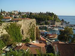
Kaleiçi, with its narrow cobbled streets of historic Turkish and Greek houses is the old center of Antalya, now mainly hotels, gift shops, and bars. New hotels such as the Sheraton are along the coast above the Konyaalti and Lara beaches.
The tourism boom has brought migrant labour to the city, fueled the growth of a large construction industry and provided transportation and other large-scale infrastructure which has led to Antalya becoming the hub of commerce in this part of Turkey.

A number of tourists visit in the summer. Some have bought real estate.[7]
Government
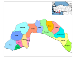
The city of Antalya is managed by a governor and a city council, with one greater city including twelve borough municipalities. Current mayor of Greater Antalya is Menderes Türel from Ak Party.
Budget
The budget for 2005 was YTL 210 million.[8]
Education
Antalya is one of the leading cities in Turkey in terms of educational institutions. In 2007, there were a total of 1387 schools, at the elementary and secondary level. There are a total of 12.000 teachers serving 275.000 students. The literacy level in Antalya province is over 95%. Antalya is also the home of Akdeniz University.
Culture
Cuisine
Antalya’s most famous include Piyaz, made with tahini (crushed sesame seeds), garlic, walnuts and boiled dried beans, spicy hibeş with mixed cumin and tahini, şiş köfte, tandır kebap, domates civesi, şakşuka and various cold Mediterranean dishes with olive oil. One local speciality is tirmis, boiled seeds of the lupin, eaten as a snack.
Festivals and events

- A number of sports championships including motor rallies.
- Antalya Golden Orange Film Festival: Turkey's largest national film festival, last week of September
- International Eurasia Film Festival: International film festival held annually
- Antalya Festival: September
- Mediterranean International Music Festival: October, 6 days
- Antalya Honey Festival: Gündogmus, August
- Antalya International Folk Music and Dance Festival Competition: Last week of August
- Aspendos International Opera and Ballet Festival: June and July
- Antalya Piano Festival: October
- Antalya Painting Festival: September
- Beachpark Rock Festival: October

- Kas-Demre Festival: December
- Mediterranean Golden Orange Wrestling: Kumluca, May
Fairs
- Anfaş Food Product Fair February
Antalya has beaches like Konyaaltı, Lara and Karpuzkaldıran. Antalya also has waterfalls such as Düden, Manavgat and Kurşunlu waterfalls are major attractions for both local and foreign tourists. For winter sports, Beydağları and Saklikent are both natural beauties of the city.
There are a large number of mosques, churches, madrasahs, masjids, hans and hamams in the city. Kaleiçi, the harbor which the city walls enclose is the oldest part of the city. In Kaleiçi, Yivli Minare, Kesik Minare and historic houses are to be found. In Kaleiçi, there is traditional Turkish architecture which strives for harmony with the nature.
Historic Sites in the city center

- Kaleici: the historical center of the city; now restored as the touristic centre of the city with its hotels, bars, clubs, restaurants, and shopping. Kaleici retains much of its historical character and the restoration won the Golden Apple Prize, the Oscar of tourism.
- Ancient monuments include the City Walls, Hıdırlık Tower, Hadrian's Gate and the Clock Tower.
- Hadrian's Gate: constructed in 2nd century BC by the Romans in honour of the Emperor Hadrian.
- Kesik Minare (Broken Minaret): Once a Byzantine Panaglia church, later converted into a mosque.
- Yivli Minare (Fluted Minaret): It was built by the Seljuks. Decorated with dark blue and turquoise tiles, the minaret eventually became the symbol of the city.
- Karatay Medresesi, Ahi Yusuf Mescidi, Iskele Mosque, Murat Paşa Mosque, Tekeli Mehmet Paşa Mosque, Balibey Mosque, Musellim Mosque, Seyh Sinan Efendi Mosque and Osman Efendi Mosque are other Islamic buildings in the city.
- "Han"s are Seljuk or Ottoman inns which have architectural significance. Examples in Antalya include Evdir Han, Kırkoz Han, Alara Han and Castle and Sarapsu (Serapsu) Han.

Museums
- Antalya Museum: Prize winning archaeology museum.
- Kaleiçi Museum: Opened in 2007 by the Mediterranean Civilizations Research Center (Akdeniz Medeniyetleri Araştırma Merkezi) see also their annual journal.
Sites of interest
- Karpuzkaldıran
- Tünek Tepe
- Karaalioglu Park
Historic sites
- See Antalya Province for information on historic sites and places of natural beauty elsewhere in the province. Those near the city include
- Aspendos: A Pamphylian city, 50 km (31 mi) from Antalya city on the Antalya-Alanya highway.
- Termessos: A Pisidian city situated high on a mountain with remnants of an agora, theatre and an odion. It has a reputation of being the most magnificent necropolis on the Mediterranean, 35 km (22 mi) northwest of Antalya.
- Ariassos: 48 km (30 mi). along the Antalya-Burdur highway and before arriving at the village of Dag turn left and Ariassos is 1 km (1 mi). further on. A city of antiquity, Ariassos was built in a valley and could survey its surroundings. The gate, the baths, the rock tombs and the mausoleum are almost intact.
- Perge: 18 km (11 mi) northeast of Antalya. The ruins are spread on two hills, the theatre on one and the acropolis on the other. According to the legend the city was built by three heroes from Troy.
- Olympos / Cirali areas; Two small rural villages located just over 80 km southwest from Antalya and boasts a beautiful 3.5 km secluded beach, the ruins of Olympos, the flames of the Chimaera / Yanartaş, as well as being a protected area by the WWF for the nesting of the Caretta Caretta or also known as the Loggerhead Sea Turtles.
- Phaselis is an ancient Lycian city in the province of Antalya in Turkey. It is located between the Bey Mountains and the forests of Olympos National Park, 16 km west of the touristic town of Kemer and on the 57th kilometre of the Antalya–Kumluca highway. Phaselis and other ancient towns around the shore can also be accessed from the sea by daily yacht tours.
Transportation

Main transportation to the city is by air and land. Sea routes are still under development.
In 2007, the airport added a new terminal. The city is improving land and sea transportation as well.
The city has a main port at the south of the Konyaaltı. It is planing to launch local routes to Kemer.
Public transportation
Antalya Bus Station (Otogar) through E87, D400, D650 routes.
There is a local bus system operated by a private corporation of the greater municipality.
The dolmus consists of municipal minibuses that travel a prescribed route.
Taxis are available.
A rail connection is in the planning stages.[9]

The tram system runs from Antalya Museum and the Sheraton Voyager and Falez hotels, along the main boulevard to the city center at Kalekapisi, Hadrian's Gate, Karaalioglu Park, and ending at Talya Oteli. Trams depart on the hour and half-hour from the terminal (east and west), and reach Kalekapisi between 10 and 15 minutes later. The one-way fare is under $1.
Currently an 11.1 kilometres (6.9 mi) light rail line is being built from one of the main city public bus hub northwest to the Zoo and beyond to suburban areas. The line is due to open in December 2008.
Major routes
The infrastructure such as roads and drains are struggling to catch up with the increase in population and tourists.
Airports
In 2007, Antalya Airport's number of passengers on international flights surpassed the total number at Istanbul Ataturk Airport and Sabiha Gökçen International Airport for the first time, officially earning the title of "the capital of Turkish tourism".[10][11]
Sister cities
|
Antalya has 8 sister cities (aka "twin towns"):
Notable people from Antalya
Sunset at Antalya
See also
References
External links
|
|||||||||||||||||||||||||||||||||||||||||