Anne Arundel County, Maryland
| Anne Arundel County, Maryland | |
| Map | |
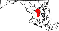 Location in the state of Maryland |
|
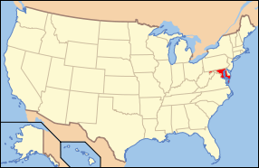 Maryland's location in the U.S. |
|
| Statistics | |
| Founded | 1650 |
|---|---|
| Seat | Annapolis |
| Largest city | Glen Burnie |
| Area - Total - Land - Water |
588 sq mi (1,523 km²) 416 sq mi (1,077 km²) 172 sq mi (445 km²), 29.25% |
| PopulationEst. - (2005) - Density |
510,878 1,228/sq mi (474/km²) |
| Website: www.aacounty.org | |
Anne Arundel County (pronounced /ˌænəˈrʌndəl/, with a stress on the run) is a county located in the U.S. state of Maryland. It is named for Anne Arundell (1615-1649), a member of the ancient family of Arundells in Cornwall, England and the wife of Cæcilius Calvert, 2nd Baron Baltimore. Its county seat is Annapolis, which is also the capital of the state. In 2000, its population was 489,656, while in 2003 the population was estimated to have reached 506,620.
Anne Arundel County forms part of the Baltimore-Washington metropolitan area. The center of population of Maryland is located on the county line between Anne Arundel County and Howard County, in the unincorporated town of Jessup.[1]
Contents |
History
The County was named for Anne Arundell, the daughter of Thomas Arundell, 1st Baron Arundell of Wardour, members of the ancient family of Arundells in Cornwall, England. She married Cæcilius Calvert, 2nd Baron Baltimore in 1627 or 1628. Anne Arundel County was an original county in Maryland, created in 1650, the year after Anne Arundell's death. The Howard District was originally part of the original Anne Arundel County. In 1851, it was broken off and made into Howard County, Maryland, the 21st of 23 Maryland counties.
Geography
Anne Arundel County is located to the south of the city of Baltimore. According to the U.S. Census Bureau, the county has a total area of 588 square miles (1,523 km²), of which, 416 square miles (1,077 km²) of it is land and 172 square miles (445 km²) of it (29.25%) is water. It is located on the western side of Chesapeake Bay, with numerous rivers and tidal creeks indenting the shoreline.
Adjacent counties
- Baltimore City (north)
- Baltimore County (north)
- Calvert County (south)
- Kent County (northeast)
- Howard County (northwest)
- Prince George's County (southwest)
- Queen Anne's County (east)
- Talbot County (southeast)
National protected area
- Patuxent Wildlife Research Refuge (part)
Climate
Anne Arundel County's climate differs on an east-to-west axis. The eastern half of the county has a Humid subtropical climate, with hot humid summers and cool, moist winters. The western half of the county lies in the transition zone between the Humid subtropical climate zone and the humid continental climate zone, with slightly colder winter temperatures and higher snowfall totals. Annual rainfall averages hover around 40 inches per year throughout the county.
Government
| Year | Republican | Democrat |
|---|---|---|
| 2008 | 50.2% 120,232 | 47.9% 114,607 |
| 2004 | 55.6% 133,231 | 43.1% 103,324 |
| 2000 | 51.9% 104,209 | 44.7% 89,624 |
| 1996 | 48.9% 83,574 | 42.2% 72,147 |
| 1992 | 43.9% 81,467 | 37.0% 68,629 |
| 1988 | 61.1% 200,641 | 38.3 125,711 |
| 1984 | 62.9% 183,181 | 36.8 107,295 |
| 1980 | 57.4% 137,620 | 30.8% 73,734 |
| 1976 | 53.6% 110,424 | 44.7% 92,037 |
| 1972 | 66.3% 112,135 | 32.4% 54,844 |
| 1968 | 49.0% 57,462 | 38.2% 44,796 |
| 1964 | 38.7% 30,755 | 61.2% 48,680 |
| 1960 | 51.7% 26,064 | 48.1% 28,006 |
Anne Arundel County has had a charter government since 1965. The government consists of a County Executive and a seven-member County Council. The County Executive and Council members are elected in the same years Maryland conducts its gubernatorial and legislative elections, and may serve a maximum of two consecutive terms.
Anne Arundel county is one of the more reliably Republican counties among the heavily-populated suburban and urban counties in the state's Baltimore-Washington corridor. Although Republicans usually have the edge in elections there are slightly more registered Democrats.
- 316,062 registered voters
- Democrat (44.20%)
- Republican (37.48%)
- Unaffiliated (17.76%)
- Other (0.56%)
County Executives
The County Executive oversees the executive branch of the County government, which consists of a number of offices and departments. The executive branch is charged with implementing County law and overseeing the operation of the County government. The next election is in 2010.
2006 Anne Arundel County Executive Election
| Name | Affiliation | Term | |
|---|---|---|---|
| Joseph W. Alton | Republican | 1965 - 1974 | |
| Robert A. Pascal | Republican | 1974 - 1982 | |
| O. James Lighthizer | Democrat | 1982 - 1990 | |
| Robert R. Neall | Republican | 1990 - 1994 | |
| John G. Gary | Republican | 1994 - 1998 | |
| Janet S. Owens | Democrat | 1998 - 2006 | |
| John R. Leopold | Republican | 2006 - |
County Council
The County Council, as the legislative branch, adopts ordinances and resolutions, and has all of the County's legislative powers.
The current members of the County Council are:
| Position | Name | Affiliation | District | |
|---|---|---|---|---|
| Member | Daryl Jones | Democrat | 1 | |
| Member | C. Edward Middlebrooks | Republican | 2 | |
| Member | Ronald C. Dillon, Jr. | Republican | 3 | |
| Member | James Benoit | Democrat | 4 | |
| Chairman | Cathleen Vitale | Republican | 5 | |
| Member | Joshua Cohen | Democrat | 6 | |
| Vice-Chairman | Edward R. Reilly | Republican | 7 | |
Law enforcement
The county has four major law enforcement agencies servicing its citizens:
- Anne Arundel County Police Department is headed by Chief James Teare, Sr.[2]
- Anne Arundel County Sheriff's Office is headed by Sheriff Ron Bateman.[3]
- Annapolis Police Department
- Maryland State Police
Transportation
Anne Arundel county is the home of Baltimore-Washington International Thurgood Marshall Airport, commonly referred to as BWI. BWI serves as the main airport for greater Baltimore. It is also an increasingly popular alternative airport to residents of the Washington, D.C., area. BWI is an East Coast hub for Southwest Airlines, meaning that direct flights are available between BWI and much of the country.
The southern portion of the Maryland Transit Administration's Light Rail system, connecting downtown Baltimore with BWI, runs through part of Anne Arundel County.
The county also has multiple stops on the MARC commuter rail service, including a stop at BWI Rail station, located near BWI Airport. Amtrak trains also stop at BWI's train station.
Additionally, the Laurel-based Connect-a-ride system operates two routes in the western portion of the county; including Severn, Arundel Mills, Maryland City, Glen Burnie, Hanover, and Odenton. Howard County's Howard Transit Silver route serves Arundel Mills shopping mall and BWI Thurgood Marshall Airport.
The county is served by one main-line interstate, Interstate 97, which is the country's only main-line interstate highway contained completely within a single county. Interstate 695, the McKeldin Beltway (commonly known as the Baltimore Beltway), runs through the northern part of the county. Interstate 895, the Harbor Tunnel Thruway, runs through the county towards the Baltimore Harbor Tunnel. Interstate 195, a spur off of Interstate 95, serves BWI Airport, while Maryland State Highway 100 runs east-west through the northern part of the county.
Interstate 595 also runs through central Anne Arundel County. This highway, however, is not signed. It is referred to by its more common names, US 50 and U.S. Route 301.
The Chesapeake Bay Bridge crosses the Chesapeake Bay from the county; it connects the western shore with the Eastern Shore in Queen Anne's County.
Demographics
As of the census[4] of 2000, there were 489,656 people, 178,670 households, and 129,178 families residing in the county. The population density was 1,177 people per square mile (455/km²). There were 186,937 housing units at an average density of 449 per square mile (174/km²). The racial makeup of the county was 81.24% White, 13.57% Black or African American, 0.30% Native American, 2.29% Asian, 0.06% Pacific Islander, 0.85% from other races, and 1.69% from two or more races. 2.63% of the population were Hispanic or Latino of any race. 17.7% were of German, 13.1% Irish, 10.5% English, 8.1% United States or American and 7.0% Italian ancestry according to Census 2000.
There were 178,670 households out of which 34.90% had children under the age of 18 living with them, 57.20% were married couples living together, 11.10% had a female householder with no husband present, and 27.70% were non-families. 21.30% of all households were made up of individuals and 6.40% had someone living alone who was 65 years of age or older. The average household size was 2.65 and the average family size was 3.09.
In the county the population was spread out with 25.20% under the age of 18, 8.10% from 18 to 24, 32.80% from 25 to 44, 23.90% from 45 to 64, and 10.00% who were 65 years of age or older. The median age was 36 years. For every 100 females there were 99.10 males. For every 100 females age 18 and over, there were 97.10 males.
The median income for a household in the county was $61,768, and the median income for a family was $69,019. Males had a median income of $43,747 versus $32,348 for females. The per capita income for the county was $27,578. About 3.60% of families and 5.10% of the population were below the poverty line, including 6.30% of those under age 18 and 5.80% of those age 65 or over.
Population history
This population history of Anne Arundel County[5] from the U.S. Census Bureau compares the population of Anne Arundel County to those of the other 23 Maryland counties and Baltimore City.
- 1900.......39,620......6th (after Allegany, Balt. Cty and City, Frederick, Washington)
- 1910.......39,553......6th
- 1920.......43,408......6th
- 1930.......55,167......6th (Frederick fewer, Prince George's more)
- 1940.......68,375......7th (Montgomery more)
- 1950......117,392......5th (Allegany and Washington fewer, now only Balt. Cty and City, Montgomery and Prince George's more)
- 1960......206,634......5th
- 1970......297,539......5th
- 1980......370,775......5th
- 1990......427,239......5th
- 2000......489,656......5th
- 2004......508,572......5th
Cities and towns
Anne Arundel County contains only two incorporated municipalities: the city of Annapolis, incorporated in 1708, and the town of Highland Beach, incorporated 1922.
Unincorporated areas are also considered as towns by many people and listed in many collections of towns, but they lack local government. Various organizations, such as the United States Census Bureau, the United States Postal Service, and local chambers of commerce, define the communities they wish to recognize differently, and since they are not incorporated, their boundaries have no official status outside the organizations in question. The Census Bureau recognizes the following census-designated places in the county:
- Arden-on-the-Severn
- Arnold
- Brooklyn Park
- Cape Saint Claire
- Crofton
- Crownsville
- Deale
- Ferndale
- Fort Meade
- Glen Burnie
- Green Haven
- Hanover
- Herald Harbor
- Hillsmere Shores
- Jessup (This CDP is shared between Howard and Anne Arundel counties.)
- Lake Shore
- Linthicum
- Londontowne
- Maryland City
- Mayo (also known as Edgewater)
- Naval Academy
- Odenton
- Parole
- Pasadena
- Pumphrey
- Riva
- Riviera Beach
- Selby-on-the-Bay
- Severn
- Severna Park
- Shady Side
- South Gate
Other unincorporated places not listed as Census-Designated Places but known in the area include:
- Annapolis Junction
- Beverly Beach
- Bristol
- Churchton
- Davidsonville
- Fairhaven
- Friendship
- Gambrills
- Galesville
- Germantown
- Gibson Island
- Hanover (a portion is also in Howard County)
- Harmans
- Harundale
- Harwood
- Jacobsville
- Lothian
- Millersville
- Orchard Beach
- Owensville
- Riverdale
- Russett
- Sherwood Forest
- Sudley
- Tracys Landing
- Waysons Corner
- West River
- Winchester-on-the-Severn
- Woodland Beach
Miscellaneous
- The newspapers of record are The Capital and the Maryland Gazette (now owned by The Capital), which was founded in 1727.[6]
Education
- Pupils in the county are zoned to Anne Arundel County Public Schools.
- Postsecondary education is offered by Anne Arundel Community College at several locations throughout the county.
- Anne Arundel County is also home to the United States Naval Academy and St. John's College, U.S., both in Annapolis.
Notable residents
- Johns Hopkins, (1795–1873), born in Anne Arundel County, noted philanthropist and founder of Johns Hopkins University.[7]
- Pat Sajak, host of the popular and long-running American television game show Wheel of Fortune.
- Mark Teixeira, Los Angeles Angels player
- Ron Wolf, former Green Bay Packers general manager
- Ronald Damien Malfi, novelist
- Steve Bisciotti, owner Baltimore Ravens
- Travis Pastrana, extreme sports
- Rudy Gay, Memphis Grizzlies player
- Denny Neagle, former Atlanta Braves, Pittsburgh Pirates, and Colorado Rockies pitcher
- Chorye Spoone - pitcher for the Frederick Keys, a minor-league affiliate of the Baltimore Orioles
- Gavin Floyd, Chicago White Sox player and top pick of the Philadelphia Phillies in 2001
References
- ↑ "Population and Population Centers by State: 2000". United States Census Bureau.
- ↑ "AACOPD Home Page". Anne Arundel County Police Department. Retrieved on 08-01-11.
- ↑ "Homepage". Anne Arundel County Sheriff's Department. Retrieved on 08-01-11.
- ↑ "American FactFinder". United States Census Bureau. Retrieved on 2008-01-31.
- ↑ "Maryland Population of Counties by Decennial Census: 1900 to 1990". United States Census Bureau (95-03-27).
- ↑ "Maryland Gazette Collection". Maryland State Archives.
- ↑ Who Was Who in America, Historical Volume, 1607–1896. Chicago: Marquis Who's Who. 1963.
See also
- Anne Arundel County Public Schools
- Anne Arundel County Police Department
External links
- Anne Arundel County official website
- Anne Arundel County Code
- Anne Arundel Elections Statistics
- Annapolis and Anne Arundel County Conference and Visitors Bureau
- Anne Arundel County Business Directory
|
|||||||||||||||||||||||
|