Ani
|
|
|
|---|---|
 |
|
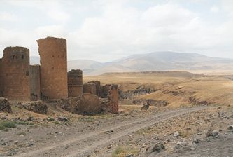
| The walls of Ani showing a defensive tower. | |
| General Information | |
| Country: | Turkey |
| Province: | Kars Province |
| Area code: | N/A |
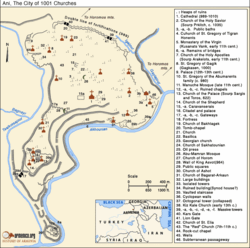
| Map of Ani. | |
 |
|
| Governor | N/A |
| Population | |
| Population: | N/A |
| Geography | |
| Location: | 40° 30' N, 43° 34'E |
| Elevation: | 1464 m |
Ani (Armenian: Անի, Latin: Abnicum)[1] is a ruined and uninhabited medieval city-site situated in the Turkish province of Kars, beside the border with Armenia. It was once the capital of a medieval Armenian kingdom that covered much of present day Armenia and eastern Turkey. The city is located on a triangular site, visually dramatic and naturally defensive, protected on its eastern side by the ravine of the Akhurian River (Turkish: Arpaçay) and on its western side by the Bostanlar or Tzaghkotzadzor valley. The Akhurian is a branch of the Araks River and forms part of the current border between Turkey and Armenia. Called the "City of 1001 Churches", it stood on various trade routes and its many religious buildings, palaces, and fortifications were amongst the most technically and artistically advanced structures in the world.[2][3]
At the height of its glory, Ani had a population of 100,000 - 200,000 people and was the rival of Constantinople, Baghdad and Cairo.[4] Long ago renowned for its splendor and magnificence, Ani has been abandoned and largely forgotten for centuries.[1][5]
History
Armenian chroniclers such as Yeghishe and Ghazar Parpetsi first mentioned Ani in the 5th century AD.[4] They described it as a strong fortress built on a hilltop and a possession of the Armenian Kamsarakan dynasty. The city took its name from the Armenian fortress-city and pagan center of Ani-Kamakh located in the region of Daranaghi in Upper Armenia.[4] Ani was also previously known as Khnamk (Խնամք), although historians are uncertain as to why it was called so.[4] Johann Heinrich Hübschmann, a German philologist and linguist who studied the Armenian language, suggested that the word may have came from the Armenian word "khnamel" (խնամել), an infinitive which means "to take care of".[4]
By the early 9th century the former territories of the Kamsarakans in Arsharunik and Shirak (including Ani) had been incorporated into the territories of the Armenian Bagratuni dynasty.[6] Their leader, Ashot Msaker (Ashot the Meateater) (806-827) was given the title of ishkhan (prince) of Armenia by the Caliphate in 804.[7] The Bagratids had their first capital at Bagaran, some 40km south of Ani, before moving it to Shirakavan, some 25km northeast of Ani, and then transferring it to Kars in the year 929. In 961 king Ashot III (953-977) transferred the capital from Kars to Ani. Ani expanded rapidly during the reign of King Smbat II (977-989). In 992 the Armenian Catholicosate moved its seat to Ani. By the start of the 11th century the population of Ani was well over 100,000, and its renown was such that it was known as "The city of forty gates" and "The city of a thousand and one churches."

Ani attained the peak of its power during the long reign of King Gagik I (989-1020). After his death his two sons quarrelled over the succession. The eldest son, Hovhannes (John) Smbat (1020-1041), gained control of Ani and his younger brother, Ashot (1020-1040), controlled other parts of the Bagratid kingdom. Hovhannes-Smbat, fearing that the Byzantine Empire would attack his now weakened kingdom, made the Byzantine Emperor Basil his heir. In January 1022, the Catholicos Peter, handed over to Basil II who was wintering with his army in Trebizond a document from Hovhannes-Smbat pledging his kingdom to the emperor in the event of his death.[8] When Hovhannes-Smbat died in 1041, the successor to Basil, Emperor Michael IV claimed sovereignty over Ani. The new king of Ani, Gagik II (1042-1045), opposed this and several Byzantine armies sent to capture Ani were repulsed. However, in 1045, after the capture of Ashot and at the instigation of pro-Byzantine elements amongst its population, Ani surrendered to Byzantine control.[9] A Greek governor was installed in the city.

In 1064 a large Seljuk Turkish army, headed by Sultan Alp Arslan, attacked Ani and after a siege of 25 days they captured the city and slaughtered its populace. In 1072 the Seljuks sold Ani to the Shaddadids, a Muslim Kurdish dynasty that had originated in Ganja. The Shaddadids generally pursued a conciliatory policy towards the city’s overwhelmingly Armenian and Christian population, and actually married several members of the Bagratid nobility. Whenever the Shaddadid governance became too intolerant, the population would appeal to the Christian kingdom of Georgia for help. The Georgians captured Ani in 1124,1161 and 1174, each time eventually returning it to the Shaddadids.
In the year 1199 the forces of the Georgian queen Tamara captured Ani and dislodged the Shaddadids, the governorship of the city was given to generals Zakare and Ivane Mkhargrdzeli.[10] At Ani, this new dynasty is generally known as the Zakarids, after its founder Zakare, and they considered themselves to be the successors to the Bagratids. Prosperity quickly returned to Ani: its defences were strengthened and many new churches were constructed. Zakare was succeeded by his son Shahanshah.
The Mongols unsuccessfully besieged Ani in 1226, but in 1236 they captured and sacked the city, massacring large numbers of its population. Ani had fallen when Shahanshah was absent. On his return the Zakarids continued to rule Ani, only now as vassals of the Mongols rather than the Georgians. Ani started its gradual but terminal decline during the Mongol period. By the 14th century the city was ruled by a succession of local Turkish dynasties, including the Jalayrids and the Kara Koyunlu (Black Sheep clan) who made Ani their capital. Tamerlane captured Ani in the 1380s. On his death the Kara Koyunlu regained control but transferred their capital to Yerevan. In 1441 the Armenian Catholicosate did the same. The Persian Safavids then ruled Ani until it became part of the Turkish Ottoman Empire in 1579. A small town remained within its walls at least until the middle 17th century, but the site was entirely abandoned by the middle of the 18th century. The depopulation of Ani was paralleled by the depopulation of its rural hinterland as a result of the yearly migrations of nomadic Kurdish tribes who would rob and murder the settled population at will.
Cultural and economic center
Ani did not lie along any previously important trade routes, but because of its size, power, and wealth it became an important trading hub. Its primary trading partners were the Byzantine Empire, the Persian Empire, the Arabs, as well as smaller nations in southern Russia and Central Asia.[4]
Modern times
In the first half of the 19th century, European travelers discovered Ani for the outside world, publishing their descriptions in academic journals and travel accounts. In 1878 the Kars region, including Ani, was incorporated into the territory of the Russian Empire. In 1892 the first archaeological excavations were conducted at Ani, sponsored by the St. Petersburg Academy of Sciences and supervised by the Russian archaeologist and orientalist Nikolai Marr (1864-1934). Marr's excavations at Ani resumed in 1904 and continued yearly until 1917. Large sectors of the city were professionally excavated, numerous buildings were uncovered and measured, the finds were studied and published in academic journals, guidebooks for the monuments and the museum were written, and the whole site was surveyed for the first time.[11] Emergency repairs were also undertaken on those buildings that were most at risk of collapse. A museum was established to house the tens of thousands of items found during the excavations. This museum was housed in two buildings: the Minuchihr mosque, and a purpose-built stone building.[12]
In 1918, during the latter stages of World War I, the armies of the Ottoman Empire were fighting their way across the territory of the newly declared Republic of Armenia, capturing Kars in April 1918. At Ani, attempts were made to evacuate the artefacts contained in the museum as Turkish soldiers were approaching the site. About 6000 of the most portable items were removed by archaeologist Ashkharbek Kalantar, a participant of Marr's excavation campaigns. At the behest of Joseph Orbeli, the saved items were consolidated into a museum collection; they are currently part of the collection of Yerevan's State Museum of Armenian History.[13] Everything that was left behind was later looted or destroyed.[14] Turkey's surrender at the end of World War 1 led to the restoration of Ani to Armenian control, but a resumed offensive against the Armenian Republic in 1920 resulted in Turkey's recapture of Ani. In 1921 the signing of the Treaty of Kars formalised the incorporation of the territory containing Ani into the Republic of Turkey.
In May 1921 the Turkish National Assembly issued a command to the commander of the Eastern Front, Kazım Karabekir, ordering that the "monuments of Ani be wiped off the face of the earth".[15] Karabekir records in his memoirs that he replied dismissively to this command,[16] but the wiping-out of all traces of Marr's excavations and building repairs suggests that the command was partially carried out.[17]
Current state

According to The Economist:
Even as a ruin, Ani has been a disputed city. In 1921 when most of the site was ceded to Turkey, the Armenians were dismayed. They have since accused the Turks of neglecting the place in a spirit of chauvinism. The Turks retort that Ani's remains have been shaken by blasts from a quarry on the Armenian side of the border.[3]
Another commentator describes:
Ani is now a ghost city, uninhabited for over three centuries and marooned inside a Turkish military zone on Turkey's border with modern Armenia. Ani's recent history has been one of continuous and always increasing destruction. Neglect, earthquakes, cultural cleansing, vandalism, quarrying, amateurish restorations and excavations - all these and more have taken a heavy toll on Ani's monuments.[2]
In the estimation of the Landmarks Foundation (a non-profit organization established for the protection of sacred sites) this ancient city:
needs to be protected regardless of whose jurisdiction it falls under. Earthquakes in 1319, 1832, and 1988, Army Target practice and general neglect all have had devastating effects on the architecture of the city. The city of Ani is a sacred place which needs ongoing protection.[5]
As a tourist site, Ani has been less than welcoming until recently. A traveler gives the following account from a few years ago:
Due to the proximity of the border, just as in Soviet days, visitors to Ani must first obtain permission from the tourist office in Kars. The lengthy procedure which is mentioned in many guidebooks has been shortcut and there is no need anymore to pay a visit to the police and the museum in Kars. Permit and entrance ticket are now issued at the Kars tourist office. The employees request the plate number of your car or taxi and try to sell you a packaged tour that they organize. This being the good news. The bad news is that, due to tensions with Armenia, photography is again strictly forbidden. When we arrived at Ani, all cameras had to remain in the car. During the visit, after a friendly body search, we were constantly escorted by border guards to ensure that no one went too close to the border.
Around 2004 these restrictions were relaxed and photography is now allowed.[18]
Now, according to an author of Lonely Planet and Frommer's travel guides to Turkey:
Official permission to visit Ani is no longer needed. Just go to Ani and buy a ticket. If you don't have your own car, haggle with a taxi or minibus driver in Kars for the round-trip to Ani, perhaps sharing the cost with other travelers. If you have trouble, the Tourist Office may help. Plan to spend at least a half-day at Ani. It's not a bad idea to bring a picnic lunch and a water bottle.[19]
Turkey's authorities now say they will do their best to conserve and develop the site and the culture ministry has listed Ani among the sites it is keenest to conserve. In the words of Mehmet Ufuk Erden, the local governor:
By restoring Ani, we'll make a contribution to humanity...We will start with one church and one mosque, and over time we will include every single monument.[3]
A spokesperson for Global Heritage Fund remarked that "Piecemeal restoration is no substitute for a master plan for Ani as a whole".[3]
The World Monuments Fund placed Ani on its 1996, 1998, and 2000 Watch Lists of 100 Most Endangered Sites.

Monuments at Ani
All the structures at Ani are constructed using the local volcanic basalt, a sort of tufa stone. It is easily carved and comes in a variety of vibrant colors, from creamy yellow, to rose-red, to jet black. The most important surviving monuments are as follows:
The cathedral of Ani
Also known as Surp Asdvadzadzin (church of the Holy Mother of God), its construction was started in the year 989, under King Smbat II. Work was halted after his death, and was only finished in 1001 (or in 1010 under another reading of its building inscription). The design of the cathedral was the work of Trdat, the most celebrated architect of medieval Armenia. The cathedral is a domed basilica (the dome collapsed in 1319). The interior contains several progressive features (such as the use of pointed arches and clustered piers) that give to it the appearance of Gothic architecture (a style which the Ani cathedral predates by several centuries).[20]
The church of St Gregory of Tigran Honents

This church, finished in 1215, is the best-preserved monument at Ani. It was built during the rule of the Zakarids and was commissioned by the wealthy Armenian merchant Tigran Honents. Its plan is of a type called a domed hall. In front of its entrance are the ruins of a narthex and a small chapel that are from a slightly later period. The exterior of the church is spectacularly decorated. Ornate carvings of real and imaginary animals fill the spandrels between blind arcade that runs around all four sides of the church. The interior contains an important and unique series of frescoes cycles that depict two main themes. In the eastern third of the church is depicted the Life of Saint Gregory the Illuminator, in the middle third of the church is depicted the Life of Christ. In the narthex and its chapel survive fragmentary frescoes that are more Byzantine in style.[21]
The church of the Holy Redeemer
This church was completed shortly after the year 1035. It had a unique design: 19-sided externally, 8-apsed internally, with a huge central dome set upon a tall drum. It was built by Prince Ablgharib Pahlavid to house a fragment of the True Cross. The church was largely intact until 1955, when the entire eastern half collapsed during a storm.[22]
The church of St Gregory of the Abughamrents
This small building probably dates from the late tenth century. It was built as a private chapel for the Pahlavuni family. Their mausoleum, built in 1040 and now reduced to its foundations, was constructed against the northern side of the church. The church has a centralised plan, with a dome over a drum, and the interior has six exedera.[23]
King Gagik's church of St Gregory
Also known as the Gagikashen, this church was constructed between the years 1001 and 1005 and intended to be a recreation of the celebrated cathedral of Zvartnots at Vagharshapat. Nikolai Marr uncovered the foundations of this remarkable building in 1905 and 1906. Before that, all that was visible on the site was a huge earthen mound. The designer of the church was the architect Trdat. The church is known to have collapsed a relatively short time after its construction and houses were later constructed on top of its ruins. Trdat's design closely follows that of Zvartnotz in its size and in its plan (a quatrefoil core surrounded by a circular ambulatory).[24]
The church of the Holy Apostles
The date of its construction is not known, but the earliest dated inscription on its walls is from 1031. It was founded by the Pahlavuni family and was used by the archbishops of Ani (many of whom belonged to that dynasty). It has a plan of a type called an inscribed quatrefoil with corner chambers. Only fragments remain of the church, but a narthex with spectacular stonework, built against the south side of the church, is still partially intact. It dates from the early 13th century. A number of other halls, chapels, and shrines once surrounded this church: Nikolai Marr excavated their foundations in 1909, but they are now mostly destroyed.[25]
The mosque of Minuchir
The mosque is named after its presumed founder, Minuchihr, the first member of the Shaddadid dynasty that ruled Ani after 1072. The oldest surviving part of the mosque is its still intact minaret. It has the Arabic word Bismillah ("In the name of God") in Kufic lettering high on its northern face. The prayer hall, half of which survives, dates from a later period (the 12th or 13th century). In 1906 the mosque was partially repaired in order for it to house a public museum containing objects found during Nikolai Marr's excavations.[26]
The citadel
At the southern end of Ani is a flat-topped hill once known as Midjnaberd (the Inner Fortress). It has its own defensive walls that date back to the period when the Kamsarakan dynasty ruled Ani (7th C. AD). Nikolai Marr excavated the citadel hill in 1908 and 1909. He uncovered the extensive ruins of the palace of the Bagratid kings of Ani that occupied the highest part of the hill. Also inside the citadel are the visible ruins of three churches and several unidentified buildings. One of the churches, the "church of the palace" is the oldest surviving church in Ani, dating from the 6th or 7th century. Marr undertook emergency repairs to this church, but most of it has now collapsed - probably during an earthquake in 1966.[27]
The city walls
A line of walls that encircled the entire city defended Ani. The most powerful defences were along the northern side of the city, the only part of the site not protected by rivers or ravines. Here the city was protected by a double line of walls, the much taller inner wall studded by numerous large and closely-space semicircular towers. Contemporary chroniclers wrote that King Smbat (977-989) built these walls. Later rulers strengthened Smbat's walls by making them substantially higher and thicker, and by adding more towers. Armenian inscriptions from the 12th and 13th century show that private individuals paid for some of these newer towers. The northern walls had three gateways, known as the Lion Gate, the Kars Gate, and the Dvin Gate (also known as the Chequer-Board Gate because of a panel of red and black stone squares over its entrance).[28]
Other monuments

There are many other minor monuments at Ani. These include a convent known as the Virgins' chapel; a church used by Chalcedonian Armenians; the remains of a single-arched bridge over the Arpa river; the ruins of numerous oil-presses and several bath houses; the remains of a second mosque with a collapsed minaret; a palace that probably dates from the 13th century; the foundations of several other palaces and smaller residences; the recently excavated remains of several streets lined with shops; etc.
Cave Village
Directly outside of Ani, there was a settlement-zone carved into the cliffs. It may have served as "urban sprawl" when Ani grew too large for its city walls. Today, goats and sheep take advantage of the caves' cool interiors. One highlight of this part of Ani is a cave church with frescos on its surviving walls and ceiling.
See also
- Ani security fence
- List of Kings of Ani
Notes
- ↑ 1.0 1.1 Hooper, Horace Everett (1910–1911). "ANI (anc. Abnicum)". Encyclopædia Britannica Eleventh Edition 2. Cambridge University Press. p. 47. Retrieved on 2007-01-21.
- ↑ 2.0 2.1 Sim, Steven. "VirtualANI - Dedicated to the Deserted Medieval Armenian City of Ani". VirtualANI. Retrieved on 2007-01-22.
- ↑ 3.0 3.1 3.2 3.3 "Ani, a Disputed City Haunted by History". The Economist (June 15, 2006). Retrieved on 2007-01-22.
- ↑ 4.0 4.1 4.2 4.3 4.4 4.5 (Armenian) Ghafadaryan, Karo. Անի (Ani). Soviet Armenian Encyclopedia. Yerevan: Armenian SSR, 1974, vol. i, pp. 407-412
- ↑ 5.0 5.1 "SACRED SITE". Ani, Turkey. Landmarks Foundation. Retrieved on 2007-01-22.
- ↑ Whittow, 213-14
- ↑ Hovannisian, 136
- ↑ Whittow, 383
- ↑ Runciman, 34
- ↑ Lordkipanidze, 150
- ↑ Kalantar, Ashkharbek, The Mediaeval Inscriptions of Vanstan, Armenia, Civilisations du Proche-Orient: Series 2 - Philologie - CDPOP 2, Vol. 2, Recherches et Publications, Neuchâtel, Paris, 1999;ISBN 2-940032-11-4
- ↑ Marr, Nicolas (2001). Ani - Rêve d'Arménie. Anagramme Editions. ISBN 2-914571-00-3.
- ↑ Kalantar, Ashkharbek (1994). Armenia from the Stone Age to the Middle Ages. Recherches et Publications. ISBN 2-940032-01-7.
- ↑ Marr, Nikoli Yakovevich: "Ani, La Ville Arménniene en Ruines", Revue des Études Arméniennes. vol. 1 (original series), 1921.
- ↑ Dadrian, Vahakn N. (1986). "The role of Turkish physicians in the World War I genocide of Ottoman Armenians". Holocaust and Genocide Studies (Oxford University Press) 1 (2): 192.
- ↑ Karabekir, 960-970
- ↑ Sim, Steven. "The City of Ani: Recent History". VirtualANI. Retrieved on 2007-01-26.
- ↑ Sim, Steven. "The Permit for Visiting Ani". VirtualANI. Retrieved on 2007-01-22.
- ↑ Brosnahan, Tom. "Ancient Armenian City of Ani". Turkey Travel Planner. Retrieved on 2007-01-22.
- ↑ Sim, Steven. "The cathedral of Ani". VirtualANI. Retrieved on 2007-01-23.
- ↑ Sim, Steven. "The church of St. Gregory of Tigran Honents". VirtualANI. Retrieved on 2007-01-23.
- ↑ Sim, Steven. "The church of the Redeemer". VirtualANI. Retrieved on 2007-01-23.
- ↑ Sim, Steven. "The church of St. Gregory of the Abughamir family". VirtualANI. Retrieved on 2007-01-23.
- ↑ Sim, Steven. "King Gagik's church of St. Gregory". VirtualANI. Retrieved on 2007-01-23.
- ↑ Sim, Steven. "Church of the Holy Apostles". VirtualANI. Retrieved on 2007-01-23.
- ↑ Sim, Steven. "The mosque of Minuchihr". VirtualANI. Retrieved on 2007-01-23.
- ↑ Sim, Steven. "The citadel of Ani". VirtualANI. Retrieved on 2007-01-23.
- ↑ Sim, Steven. "The city walls of Ani". VirtualANI. Retrieved on 2007-01-23.
References
- Whittow, Mark (August 5, 1996). The Making of Byzantium, 600-1025. Berkeley: University of California Press. pp. 480. ISBN 0-520-20497-2.
- Lordkipanidze, Mariam (1987). Georgia in the XI-XII Centuries. Tbilisi: Genatleba. pp. 184. ASIN B0006EONOE
- Hovannisian, Richard G. (August 15, 1997). The Armenian people from ancient to modern times: from antiquity to the fourteenth century. Palgrave Macmillan. pp. 386. ISBN 0-312-10168-6.
- Runciman, Steven (December 25, 1987). A History of the Crusades Vol. I: The First Crusade and the Foundations of the Kingdom of Jerusalem. Cambridge: Cambridge University Press. pp. 394. ISBN 0-5213-4770-X.
- (Turkish) Karabekir, Kazım (1960). Istiklal Harbimiz. Istanbul. pp. 1171.
Further reading
- Cowe, S. Peter (2001). S. Peter Cowe (ed.). ed.. ANI World Architectural Herritage of a Medieval Armenian Capital.
- Kevorkian, Raymond (2001). Raymond Kevorkian (ed.). ed.. Ani - Capitale de l'Arménie en l'An Mil.
- Lynch, H.F.B. (1901). Armenia, Travels and Studies.
- Marr, Nicolas Yacovlevich (2001). Ani - Rêve d'Arménie.
- Minorsky, V. (1953). Studies in Caucasian History.
- Paolo, Cuneo (1984). Documents of Armenian Architecture, volume 12: Ani.
- Kalantar, Ashkharbek (1994). Armenia from the Stone Age to the Middle Ages.
- Sinclair, Thomas Allen (1987). Eastern Turkey, an Architectural and Archeological Survey, volume 1.
External links
- Virtual Ani - has clickable maps, extensive history and photos
- 3D Models of Ani
|
|||||