Amur River
Amur River
|
|||||||
|---|---|---|---|---|---|---|---|
| Chinese name | |||||||
| Traditional Chinese: | 黑龍江 | ||||||
| Simplified Chinese: | 黑龙江 | ||||||
| Literal meaning: | "Black Dragon River" | ||||||
|
|||||||
| Manchu name | |||||||
| Manchu: | (Sahaliyan Ula) |
||||||
| Mongolian name | |||||||
| Mongolian: | Хар Мөрөн (Khar Mörön) |
||||||
| Russian name | |||||||
| Russian: | Амур (Amur) |
||||||
The Amur River (Russian: река Аму́р) or Heilong Jiang (Chinese: 黑龙江) is the world's ninth longest river, forming the border between the Russian Far East and Northeastern China.
Contents |
History and context
In many historical references these two geopolitical entities are known as Outer Manchuria (Russian Manchuria) and Inner Manchuria, respectively. The Chinese province of Heilongjiang on the south bank of the river is named after it, as is the Russian Amur Oblast on the north bank. The name Black River (sahaliyan ula) was used by the Manchu and the Qing Dynasty who always regarded this river as sacred.
The Amur River is a very important symbol of — and an important geopolitical factor in — Chinese-Russian relations. The Amur was especially important in the period of time following the Sino-Soviet political split in the 1960s.
River Steamers plied the Amur in the first years of the century. Mining dredges were imported from America to work the placer gold of the river. Barge and river traffic was greatly hindered by the Civil War of 1918-22. The ex-German Yangtse gunboats Vaterland and Otter, on Chinese Nationalist Navy service, patrolled the Amur in the 1920s.
The economy of the Amur Basin includes manufacturing, metallurgy, iron mining, non-ferrous metals, gold, coal, hydroelectricity, wheat, millet, soybeans, fishing, timber and Chinese-Russian trade. The Daqing oilfield, which is the world's 4th-largest oilfield, is located near Daqing City in Heilongjiang, a few hundred kilometers from the river.
Direction
| Amur | |
|---|---|
 |
|
| Origin | The mountains of Mongolia |
| Mouth | The Pacific Ocean, through the Tartar Strait |
| Basin countries | China, Russia, Mongolia |
| Length | 4,049 km (2,516 mi) |
| Source elevation | 1930 |
| Avg. discharge | 9.181 |
| Basin area | 1,855,000 km² (716,200 mi²) |
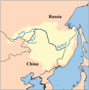
Flowing across northeast Asia for over 4,444 km (2,700 mi), from the mountains of northeastern China to the Sea of Okhotsk (near Nikolayevsk-na-Amure), it drains a remarkable watershed that includes diverse landscapes of desert, steppe, tundra, and taiga, eventually emptying into the Pacific Ocean through the Strait of Tartary, where the mouth of the river faces the northern end of the island of Sakhalin.
The Amur has always been closely associated with the island of Sakhalin at its mouth, and most names for the island, even in the languages of the indigenous peoples of the region, are derived from the name of the river: "Sakhalin" derives from a Tungusic dialectal form cognate with Manchu sahaliyan ("black," as in sahaliyan ula, "Black River"), while Ainu and Japanese "Karaputo" or "Karafuto" is derived from the Ainu name of the Amur or its mouth. Anton Chekhov vividly described the Amur River in writings about his journey to Sakhalin Island in 1890.
The average annual discharge varies from 6000 m³/s (1980) - 12000 m³/s (1957), leading to an average 9819 m³/s or 310 km³ per year. The maximum runoff measured occurred in Oct 1951 with 30700 m³/s whereas the minimum discharge was recorded in March 1946 with a mere 514 m³/s.[1]
Tributaries
The Amur proper is 2,874 km long after the junction of two rivers:
- Northern tributary: the Shilka, originating from the eastern slopes of the Khentii Mountains in Mongolia.
- Southern tributary: the Argun, originating on the western slopes of the Great Khingan Range (大興安嶺) in northeast China.
Major tributaries are:
- the Shilka,
- the Argun,
- the Zeya,
- the Bureya,
- the Sunggari,
- the Ussuri,
- the Amgun
The Amur is bordered by Heilongjiang province of China in the south, and Amur Oblast, Jewish Autonomous Oblast, and Khabarovsk Krai of Russia in the north. The final stretch of the Amur passes through Khabarovsk Krai. It passes by the following cities:
- Huma (China, south bank)
- Blagoveshchensk (Russia, north bank)
- Heihe (China, south bank)
- Jiayin (China, south bank)
- Tongjiang (China, south bank)
- Fuyuan (China, south bank)
- Khabarovsk (Russia, south bank)
- Komsomolsk-na-Amure (Russia, north bank)
- Nikolayevsk-na-Amure (Russia, north bank)
Transportation

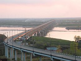
Valery Solomonovich Gurevich, government vice-chairman of Russia’s Jewish Autonomous Oblast said that China and Russia started construction of the Amur Bridge Project at the end of 2007. The bridge will link Nizhneleninskoye in the Jewish Autonomous Oblast with Tongjiang in Heilongjiang Province. The 2,197-meter-long bridge, with an estimated investment of nearly US$230 million, is expected to be finished by the end of 2010, Gurevich said.[2] Gurevich said that the proposal to construct a bridge across the river was actually made by Russia, in view of growing cargo transportation demands. "The bridge, in the bold estimate, will be finished in three years," Gurevich said.[3]
See also
- Amuri, a Tampere district named after battles at river Amur during the Russo-Japanese war.
- Amur cork tree
- Amur Falcon
- Amur Leopard
- Amur Tiger
- Amur Honeysuckle
- Geography of China
- Geography of Russia
- Sino-Soviet border conflict
- Jilin chemical plant explosions 2005
- Home of the Kaluga (Acipenseriformes)
References
- ↑ "Amur at Komsomolsk". UNESCO. Retrieved on 2008-08-14.
- ↑ "China-Russia Trade to Top US$40b". China Daily (2007-06-18). Retrieved on 2008-08-14.
- ↑ "Cross-border bridge on Heilong River to bring Russia closer". China Daily (2007-06-28). Retrieved on 2008-08-14.