Amapá
|
State of Amapá
|
||||||
|---|---|---|---|---|---|---|
|
||||||
 |
||||||
| Capital (and largest city) |
Macapá | |||||
| Demonym | Amapaense | |||||
| Government | ||||||
| - | Governor | Antônio Waldez Góes da Silva | ||||
| - | Vice Governor | Pedro Paulo Dias de Carvalho | ||||
| Area | ||||||
| - | Total | 142.814,585 km² (18th) | ||||
| Population | ||||||
| - | 2006 estimate | 615,715 (16th) | ||||
| - | 2005 census | 596,169 | ||||
| - | Density | 4.3/km² (24th) | ||||
| GDP | 2005 estimate | |||||
| - | Total | R$ 4,367,000,000 (26th) | ||||
| - | Per capita | R$ 7,344 (15th) | ||||
| HDI (2005) | 0.780 (medium) (11th) | |||||
| Abbreviation | BR-AP | |||||
| Time zone | BRT (UTC-3) | |||||
| - | Summer (DST) | BRST (UTC-2) | ||||

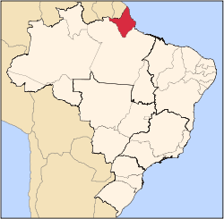
Amapá (pronounced [amaˈpa][1]) is one of the states of Brazil, located in the extreme north, bordering French Guiana and Suriname to the north. To the east is the Atlantic Ocean, and to the south and west is the Brazilian state of Pará. Perhaps one of the main features of the State is the River Oiapoque, as it was once considered the northernmost point of Brazil. The river's estuary is at the extreme north of the Brazilian coast and it is often used to describe the remote points of Brazil. The dominate landscape of the region - 90 percent of the total area - is the huge Amazon Rainforest. Unexplored forests dominate 70 percent of its territory. Another attraction is the Equator, which divides not only the state but also the Northern and Southern hemispheres. The only method by which to reach Macapá is through boat or airplane.
Contents |
History
As the "Capitania" of Costa do Cabo Norte, the region was invaded by the English and Dutch, who were repelled by the Portuguese. The Treaty of Utrecht, in 1713 established the boundaries between Brazil and French Guiana, but these were not respected by the French. In the 18th century, France retook control of the area. This dispute would continue until 1900.
With the discovery of gold and the increasing value of rubber on the international market during the 19th century contributing to increases in population in Amapá, the territorial dispute with France was brought to a head; finally on December 1st, 1900, the Arbitration Commission of Geneva ceded possession of the territory to Brazil, which incorporated it into the state of Pará with the joint name of Araguari (named for the river of the same name). It became the federal territory of Amapá in 1943.
The discovery of rich manganese deposits in Serra do Navio in 1945 revolutionized the local economy, but Amapá did not achieve statehood until October 5th, 1988 with the promulgation of the new Brazilian Constitution.
Geography

The State of Amapá has also the lowest deforestation rate of its original vegetation: only 2%. Most of its territory is occupied by forests, with the remaining area corresponding to savannah and plain areas. At the seaside, almost intact beaches get mixed with swamps, composing the largest Brazilian representation of this biome, where this mix of salt and fresh water is perfect for the reproduction of the food chain for several animal species.
Climate
An equatorial climate is a type of tropical climate in which there is no dry season – all months have mean precipitation values of at least 60mm. It is usually found at latitudes within five degrees of the equator – which are dominated by the Intertropical Convergence Zone. The equatorial climate is denoted Af in the Köppen climate classification. Tropical rainforest is the natural vegetation in equatorial regions.
Vegetation
The Amazon represents over half of the planet's remaining rainforests and comprises the largest and most species-rich tract of tropical rainforest in the world. Wet tropical forests are the most species-rich biome, and tropical forests in the Americas are consistently more species rich than the wet forests in Africa and Asia.[2] As the largest tract of tropical rainforest in the Americas, the Amazonian rainforests have unparalleled biodiversity. More than 1/3 of all species in the world live in the Amazon Rainforest.[3]
Demographics
According to the IBGE of 2007, there were 619,000 people residing in the state with a population density of 4.3/km².
Urbanization: 93.7% (2006); Population growth: 5.7% (1991-2000); Houses: 144,000 (2006).[4]
The last PNAD (National Research for Sample of Domiciles) census revealed the following numbers: 429,000 Pardo (Brown) people (69.4%), 148,000 White people (24.0%), 40,000 Black people (6.5%), 6,000 Asian or Amerindian people (0.1%).[5]
Economy
The service sector is the largest component of GDP at 87.6%, followed by the industrial sector at 7.8%. Agriculture represents 4.6% of GDP (2004). Amapá exports: wood 75.5%, ores 18.7%, heart of palm 5.5% (2002).
Share of the Brazilian economy: 0.2% (2005).
Education
Portuguese is the official national language, and thus the primary language taught in schools. But French , due to the proximity of French Guiana, is part of the official high school curriculum.[6]
Educational institutions
- Universidade Federal do Amapá (Unifap) (Federal University of Amapá);
- Centro de Ensino Superior do Amapá (Ceap);
- Instituto de Ensino Superior do Amapá (Iesap);
- Instituto Macapaense de Ensino Superior (Immes);
- and many others.
Infrastructure
International Airport
The state of Amapá will soon gain a new airport. Infraero will start work on the new Macapá International Airport, which will have 17 thousand square meters of space to serve 700 thousand passengers a year. The current airport, with an area of 2.9 thousand square meters, operates annually with 324 thousand passengers. The work, scheduled for conclusion in 30 months, will enlarge the parking lot to 258 spots against the current 80 and expand the total area from 2.4 thousand to 11 thousand square meters. The apron area will be increased from its current 21 thousand to 30 thousand square meters, with capacity for four large airplanes and 30 small aircraft.
Flag
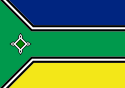
The flag was adopted by decree No. 008 of April 23, 1984. The blue color on the top symbolizes the sky over Amapá and justice, the green in the middle the native rainforest, and the yellow on the bottom the Union and its natural resources. The black in the small strips stands for the deceased who worked for the state, and the white for the will of the state to live in peace and stability. The symbol at the left symbolizes the Fortress of São José, out of which the state capital grew.
Before 1984 the state had a red-white-red flag very similar to the flag of Peru.
References
- ↑ In Brazilian Portuguese. The European Portuguese pronunciation is [ɐmɐˈpa].
- ↑ Turner, I.M. 2001. The ecology of trees in the tropical rain forest. Cambridge University Press, Cambridge. ISBN 0-521-80183-4
- ↑ Amazon Rainforest, Amazon Plants, Amazon River Animals
- ↑ Source: PNAD.
- ↑ (in Portuguese) (PDF)Síntese de Indicadores Sociais 2007. Amapá, Brazil: IBGE. 2007. ISBN 85-240-3919-1. ftp://ftp.ibge.gov.br/Indicadores_Sociais/Sintese_de_Indicadores_Sociais_2007/Tabelas. Retrieved on 2007-07-18.
- ↑ http://f3e.asso.fr/IMG/pdf/Synthese_en_francais.pdf
See also
- (English) Brazil
- (Portuguese) Official Website
- (English) Brazilian Tourism Portal
- (Portuguese) Amapa's location on a 3D globe (Java)
- (English) Calçoene - Amapá town, site of pre-colonial observatory
|
||||||||||||||||||||||||||
|
|||||||||||||||||||||||||||||
|
|||||||||||||||||||||||