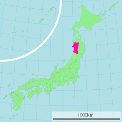
Akita Prefecture
| Akita Prefecture | |||||||||
|
|||||||||
 |
|||||||||
| Capital | Akita (city) | ||||||||
| Region | Tōhoku | ||||||||
| Island | Honshū | ||||||||
| Governor | Sukeshiro Terata | ||||||||
| Area (rank) | 11,612.22 km² (6th) | ||||||||
| - % water | 0.7% | ||||||||
| Population (January 1, 2005) | |||||||||
| - Population | 1,145,501 (35th) | ||||||||
| - Density | 98.6 /km² | ||||||||
| Districts | 6 | ||||||||
| Municipalities | 25 | ||||||||
| ISO 3166-2 | JP-05 | ||||||||
| Website | www.pref.akita.jp/e/ | ||||||||
| Prefectural Symbols | |||||||||
| - Flower | Fuki (a kind of butterbur, Petasites japonicus) | ||||||||
| - Tree | Akita-sugi (Cryptomeria japonica) | ||||||||
| - Bird | Copper pheasant (Phasianus soemmerringii) | ||||||||
Symbol of Akita Prefecture |
|||||||||
| Template ■ Discussion ■ Parameter ■ WikiProject Japan | |||||||||
Akita Prefecture (秋田県 Akita-ken?) is a prefecture of Japan located in the Tōhoku Region of northern Japan. The capital is the city of Akita.
Contents |
History
Separated from the principal Japanese centres of commerce, politics, and population by several hundred kilometres and the Ou and Dewa mountain ranges to the east, Akita remained largely isolated from Japanese society until after the year 600CE. Populated principally by the Ainu people, Akita was a region of hunter-gatherers and principally nomadic tribes.
The first historical record of Akita-ken dates to 658CE, when the General Abe no Hirafu (阿部比羅夫) conquered the native Ezo tribes at Akita city and Nushiro. Hirafu, then governor of the Koshi region (the northwest part of Honshū island bordering the Sea of Japan), established a fort on the Mogami river, and thus began the Japanese settlement of the region.
In 733, a new military settlement—later renamed Akita Castle (秋田城)—was built in modern-day Akita city at Takashimizu, and more permanent roads and structures were developed. The region was used as a base of operations for the Japanese empire as it drove the native Ezo people from northern Honshū.
It shifted hands several times in the interim. During the Tokugawa shogunate it was appropriated to the Satake family in 1602, who ruled the region for 260 years, developing the agriculture and mining industries that are still predominant today. Throughout this period, it was classified as part of Dewa Province and remained politically quite stable. In 1871, during the Meiji Restoration, Dewa province was reshaped and the old daimyo regions (called "han") were abolished and administratively reconstructed, resulting in the modern-day borders of Akita.
The famous Heian period waka poet, Ono no Komachi, is said to have been born here (but the true location of her birth is uncertain).
Geography
Located in the north of Honshū Island, Akita Prefecture faces the Sea of Japan in the west and is bordered by Aomori in the north, Iwate in the east, Miyagi in the south east, and Yamagata in the south.
Akita Prefecture is rectangular in shape, roughly 181 km from north to south and 111 km from west to east. The Ōu Mountains mark the eastern border of the prefecture, and the higher Dewa Mountains run parallel through the center of the prefecture. Like much of northern Japan, the prefecture has cold winters, particularly away from the sea.
The Oga Peninsula is a prominent feature of the coastline.
Cities
Thirteen cities are located in Akita Prefecture:
|
|
Towns and villages

These are all of the towns and villages in each district.
|
|
Mergers
Economy
Like much of Tōhoku, Akita's economy remains dominated by traditional industries, such as agriculture, fishing, and forestry. This has led many young people to migrate to Tokyo and other large cities. Akita is famous for its Sake breweries. Akita Prefecture is where declines in population are most severe, it is one of four prefectures in Japan registering declines in population since 1945.
Culture
Akita is well-known for having the highest consumption of sake in Japan[1], and thought to be the origin of the Akita breed of dog which carries the prefecture's name. The women of the region, referred to as Akita bijin (秋田美人; 'beauties of Akita'), have also gained widespread renown for their white skin, rounded faces and high voices, all of which are considered highly desirable. Ono no Komachi is widely known as a famous example of an Akita bijin.
Tourism


Near Lake Tazawa, there are a number of hot springs resorts (onsen), these are popular with tourists from all over Japan. In addition there are a number of seasonal festivals (matsuri) which offer a glimpse of rural or traditional Japan. Some famous festivals are the Akita Kanto festival, the Omagari fireworks festival, and the Yokote Kamakura festival.
Kakunodate is a particularly charming old town, full of preserved samurai houses. The Aoyagi house is the former residence of Odano Naotake, the man who illustrated Japan's first modern guide to the human anatomy. The house is now a museum and gallery of medical illustrations and traditional crafts.
Media
Television
- Akita Broadcasting System (ABS)
- Akita Television (AKT)
- Akita Asahi Broadcasting (AAB)
References
External links
- Official Akita Prefecture website (English)
- Akita Sightseeing Guide (English)
- Akitafan (Tourist information provided by Akita Prefectural Government (English)
|
|||
| Cities | |||
|---|---|---|---|
| Akita (capital) | Daisen | Katagami | Kazuno | Kitaakita | Nikaho | Noshiro | Oga | Ōdate | Semboku | Yokote | Yurihonjō | Yuzawa | |||
| Districts | |||
| Kazuno | Kitaakita | Minamiakita | Ogachi | Semboku | Yamamoto | |||
|
|
|||||||||||