Administrative divisions of Portugal
The administrative divisions of Portugal are undergoing changes.
Until the early 2000s, Portugal was divided into districts (distritos, singular: distrito), municipalities (municípios, singular: município, also known as concelho) and civil parishes (freguesias), only the last two having some political autonomy. This political division had been subject to many attempts to create a more "logical" and practical division in order to better reflect the economical, cultural and demographic reality. A public consultation through a referendum in 1999 was made in order to create statutory and political regions with some degree of autonomy, but was rejected in the polls.
Today, according to the Constitution of the Portuguese Republic the political subdivisions of the Portuguese territory are the (referended) regions (regiões – singular: região) – not yet implemented, the municipalities (municípios, singular: município) and the civil parishes (freguesias, singular: freguesia). However, according to Law No. 11/2003 of May 13, the municipalities are allowed to organize themselves into intermunicipal communities (comunidades intermunicipais, singular: comunidade intermunicipal), that can be of general or specific purposes; and metropolitan areas (áreas metropolitanas, singular: área metropolitana), that can be of two types: great metropolitan areas (grandes áreas metropolitanas, singular: grande área metropolitana) and urban communities (comunidades urbanas, singular: comunidade urbana). The existence of the political subdivision of "district" is now disappearing. However they are still relevant, serving as a base for a number of administrative divisions.
On the other hand, the Portuguese territory was reorganized in accordance with a system of statistical regions and subregions known as Nomenclature of Territorial Units for Statistics that are the basis of the statistical system of information for the entire European Union.
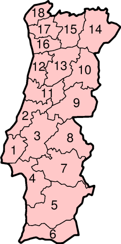
Districts
The district, although in process of being phased out because of the decentralization process, remains as the most relevant subdivision of the country, serving as a basis for a series of administrative divisions like the electoral circles or the district football associations. There are 18 districts in mainland Portugal:
|
 |
NUTS
The Nomenclature of Territorial Units for Statistics (NUTS) Regions, comprising three levels, are instrumental in European Union's Structural Fund delivery mechanisms. The standard was developed by the European Union, and thus only covers the member states of the EU in detail. It has been extensively used by the EU's national governments, Eurostat and other EU bodies for statistical and policy matters.[1][2]
NUTS I
The first and broadest subdivision of Portugal is between Mainland Portugal and the autonomous regions of Azores and Madeira archipelagos. This subdivision corresponds to NUTS I.
NUTS II and III: regions and subregions
Although the districts are still the most relevant subdivision, the regions are growing in importance, and gaining some autonomy and power. Portugal is divided into five regions, administered by the Commissions for Coordination and Regional Development (Comissões de Cooperação e Desenvolvimento Regional) in mainland Portugal, plus the two autonomous regions that are their own NUTS II regions. These 7 regions are subdivided into 30 subregions (subregiões, singular: subregião) with statistical relevance only. Each region is listed (north to south) with its subregions (alphabetically) indented below.


- Norte (8)
- Alto Trás-os-Montes
- Ave
- Cávado
- Douro
- Entre Douro e Vouga
- Grande Porto
- Minho-Lima
- Tâmega
- Centro (12)
- Baixo Mondego
- Baixo Vouga
- Beira Interior Norte
- Beira Interior Sul
- Cova da Beira
- Dão-Lafões
- Médio Tejo
- Oeste
- Pinhal Interior Norte
- Pinhal Interior Sul
- Pinhal Litoral
- Serra da Estrela
- Lisboa (2)
- Grande Lisboa
- Península de Setúbal
- Alentejo (5)
- Alentejo Central
- Alentejo Litoral
- Alto Alentejo
- Baixo Alentejo
- Lezíria do Tejo
- Algarve (1)
- Autonomous Region of Azores (1)
- Autonomous Region of Madeira (1)
These regions are the Portuguese NUTS II subdivisions, based not at the district level, but at the municipal one, leading to large inconsistencies between district and region limits.
The two Autonomous Regions (regiões autónomas, singular região autónoma), in the Atlantic Ocean, correspond to NUTS I, II and III.
LAU I and II: municipalities and civil parishes
Municipalities and civil parishes were at NUTS IV and V levels, but these nomenclature units have being abolished and substituted by LAU's. So, today the municipality is at LAU 1 level and the civil parish is at LAU 2 level.
There are 308 municipalities in Portugal, that are colloquially known by councils (concelhos, singular: concelho). Like the districts, the municipalities are usually named for its biggest city, or at least, of its historical most important city or town, however, the municipality is, usually, much larger than the city or town after which it is named.
The municipality has been the most stable subdivision of Portugal. They have great importance as they hold the local administrative and executive power. Since the creation of a democratic local administration in 1976, after the Carnation revolution of April 25, 1974, the Portuguese municipalities have been ruled by a bicameral system. The municipal chamber (câmaras municipais, singular: câmara municipal) is the executive body, and is composed by the president of the municipality and an even number of councillors whose number depends on the municipality's population, and which are elected proportionally to the votes received by the various parties or groups of citizens that take part in the municipal elections. The municipal assembly (assembleias municipais, singular: assembleia municipal) is composed by the presidents of all the civil parishes plus a number of directly elected representatives that has to be at least equal to the number of civil parish presidents plus one, and which otherwise depends on the municipal population. These representatives are also elected proportionally to the votes obtained by the various political forces in dedicated elections.
The 308 municipalities are further divided into 4,261 civil parishes, each one governed by their civil parish juntas (juntas de freguesia, singular: junta de freguesia).
Metropolitan areas and intermunicipal communities
The present (as of 2006) political intentions are to create a territorial division based on association. This system, while requiering territorial continuity, allows for the free association between neighbouring municipalities to form an entity with some degree of autonomy from the central government.
Great Metropolitan Areas
The Greater Metropolitan Areas are territorial units formed by grouping municipalities. Their purpose is to economize on municipal investments and services. New Portuguese laws approved in May 2003 give the metropolitan areas greater autonomy. They are required to include at least nine municipalities with a total of at least 350,000 inhabitants.
Lisbon (Lisboa)
The Lisbon Metropolitan Area (GAM de Lisboa) consists of 18 municipalities (in two subregions: Grande Lisboa and Península de Setubal). (Largest to smallest, by population): Lisbon, Sintra, Loures, Amadora, Cascais, Oeiras, Almada, Seixal, Odivelas, Vila Franca de Xira, Setúbal, Barreiro, Moita, Mafra, Palmela, Montijo, Sesimbra, and Alcochete. By the 2001 census, its population was 2,547,665 inhabitants. Note: a subregion known as Grande Lisboa (Greater Lisbon), this term officially, refers to the southern Lisbon district territory, Península de Setubal subregion includes the municipalities in northern Setubal district. The capital of the Greater Metropolitan Area is the densely populated city of Lisbon. Other densely populated cities in the GAM de Lisboa are: Amadora, Odivelas, Almada, Setubal, Barreiro, Amora (Seixal municipality) and Agualva-Cacem & Queluz (both in Sintra municipality).
Principal airport: Lisbon/Portela (LIS) in Lisbon and Loures. Chief ports: Lisbon, Setubal.
Porto
Greater Metropolitan Area of Porto consists of 14 municipalities (largest to smallest, by population): Vila Nova de Gaia, Porto, Matosinhos, Gondomar, Santa Maria da Feira, Maia, Valongo, Vila do Conde, Santo Tirso, Póvoa de Varzim, Trofa, Espinho, Arouca and São João da Madeira. By the 2001 census, its population was 1,509,958 inhabitants and the capital is Oporto. Oliveira de Azeméis and Vale de Cambra will soon join GMA of Porto.
Minho
The Greater Metropolitan Area of Minho has 12 municipalities (largest to smallest): Braga, Guimarães, Vila Nova de Famalicão, Barcelos, Fafe, Vila Verde, Vizela, Celorico de Basto, Amares, Cabeceiras de Basto, Vieira do Minho and Terras de Bouro. Braga is the capital. By the 2001 census, its population was 754,830 inhabitants.
Aveiro
The Greater Metropolitan Area of Aveiro has 13 municipalities (largest to smallest): Aveiro, Oliveira de Azeméis, Ovar, Águeda, Ílhavo, Anadia, Estarreja, Vale de Cambra, Albergaria-a-Velha, Vagos, Oliveira do Bairro, Sever do Vouga and Murtosa. Aveiro is the capital. By the 2001 census, its population was 460,157 inhabitants. Both Oliveira de Azeméis and Vale de Cambra will soon exit Greater Metropolitan Area of Aveiro.
Coimbra
The Greater Metropolitan Area of Coimbra has 16 municipalities (largest to smallest): Coimbra, Figueira da Foz, Cantanhede, Montemor-o-Velho, Soure, Mealhada, Penacova, Lousã, Condeixa-a-Nova, Miranda do Corvo, Mira, Tábua, Mortágua, Vila Nova de Poiares, Penela and Góis. By the 2001 census, its population was 430,845 inhabitants.
Algarve
The Greater Metropolitan Area of the Algarve has 16 municipalities (largest to smallest): Loulé, Faro, Portimão, Olhão, Silves, Albufeira, Lagos, Tavira, Lagoa, Vila Real de Santo António, São Brás de Alportel, Monchique, Castro Marim, Aljezur, Vila do Bispo and Alcoutim. Faro is the capital. By the 2001 census, its population was 391,819 inhabitants.
Viseu
The Greater Metropolitan Area of Viseu has 21 municipalities (largest to smallest): Viseu, Tondela, Seia, Mangualde, São Pedro do Sul, Castro Daire, Gouveia, Nelas, Sátão, Santa Comba Dão, Vouzela, Moimenta da Beira, Oliveira de Frades, Carregal do Sal, Penalva do Castelo, Tarouca, Aguiar da Beira, Sernancelhe, Vila Nova de Paiva, Fornos de Algodres and Penedono. Viseu is the capital and the largest city. Most of the Gam de Viseu, except for the cities os Viseu, Mangualde and Seia, are actually rural or semi-urban. By the 2001 census, its population was 354,162 inhabitants.
Urban Communities
They are also metropolitan areas, but smaller/with fewer than 500,000 inhabitants..
Oeste
Oeste (Eng. West) is a community northwest of Lisbon in the central-litoral part of Portugal. The capital and largest city is Caldas da Rainha and it has 12 municipalities (largest to smallest): Torres Vedras, Alcobaça, Caldas da Rainha, Alenquer, Peniche, Lourinhã, Nazaré, Cadaval, Bombarral, Óbidos, Arruda dos Vinhos and Sobral de Monte Agraço. By the 2001 census, its population was 338,747 inhabitants.
Vale do Sousa
Vale do Sousa is a community just east of Oporto, the first to be formed (January 2004) and it has a growing economical and industrial environment. Vale do Sousa consists of 6 municipalities (largest to smallest): Paredes, Penafiel, Felgueiras, Paços de Ferreira, Lousada and Castelo de Paiva. Penafiel is the capital. The most populous city is Felgueiras. By the 2001 census, its population was 327,768 inhabitants.
Leiria
It has 8 municipalities (largest to smallest): Leiria, Pombal, Ourém, Marinha Grande, Porto de Mós, Batalha, Ansião and Alvaiázere. Leiria is the capital as well the largest city. By the 2001 census, its population was 317,271 inhabitants.
Lezíria do Tejo
It has 11 municipalities (largest to smallest): Santarém, Cartaxo, Benavente, Almeirim, Coruche, Rio Maior, Azambuja, Salvaterra de Magos, Chamusca, Alpiarça and Golegã. Santarém is the capital and largest city. By the 2001 census, its population was 240,322 inhabitants.
Baixo Alentejo
It is the largest political division of Portugal (by area) and has 18 municipalities (largest to smallest): Beja, Santiago do Cacém, Odemira, Serpa, Moura, Grândola, Alcácer do Sal, Sines, Aljustrel, Ferreira do Alentejo, Mértola, Almodôvar, Castro Verde, Ourique, Vidigueira, Cuba, Alvito and Barrancos. By the 2001 census, its population was 234,481 inhabitants. The capital and largest city is Beja.
Trás-os-Montes
It occupies the northeastern area of Portugal and has 15 municipalities (largest to smallest): Chaves, Bragança, Mirandela, Valpaços, Macedo de Cavaleiros, Vila Pouca de Aguiar, Montalegre, Mogadouro, Vinhais, Miranda do Douro, Ribeira de Pena, Boticas, Alfândega da Fé, Vimioso and Freixo de Espada à Cinta The capital and largest city is Bragança and by the 2001 census, its population was 227,883 inhabitants.
Valimar
Valimar is a community, north of Oporto (formed March 2004) in the historical region of Entre-Douro-e-Minho. Its name suggest sea (Port. mar), Valleys (Port. vale) and Lima River. Valimar gathers 6 municipalities: Arcos de Valdevez, Caminha, Esposende, Ponte da Barca, Ponte de Lima and Viana do Castelo.The largest (and only city) is Viana do Castelo. The capital of the community is town of Ponte de Lima. By the 2001 census, its population was 220,799 inhabitants. ???
Centro Alentejo
It has 16 municipalities (largest to smallest): Évora, Elvas, Montemor-o-Novo, Estremoz, Vendas Novas, Reguengos de Monsaraz, Vila Viçosa, Campo Maior, Borba, Arraiolos, Redondo, Portel, Alandroal, Mora, Viana do Alentejo and Mourão. The capital/largest city is Évora. By the 2001 census, its population was 204,798 inhabitants.
Baixo Tâmega
It has 7 municipalities (largest to smallest): Amarante, Marco de Canavezes, Baião, Cinfães, Celorico de Basto, Resende and Mondim de Basto. The capital and largest city is Amarante. By the 2001 census, its population was 198,058 inhabitants.
Douro
It has 15 municipalities (largest to smallest): Vila Real, Lamego, Peso da Régua, Alijó, Torre de Moncorvo, São João da Pesqueira, Santa Marta de Penaguião, Vila Nova de Foz Côa, Vila Flor, Carrazeda de Ansiães, Armamar, Sabrosa, Tabuaço, Murça and Mesão Frio. The capital/largest city is Vila Real. By the 2001 census, its population was 195,203 inhabitants.
Médio Tejo
It has 11 municipalities (largest to smallest): Tomar, Abrantes, Torres Novas, Entroncamento, Alcanena, Ferreira do Zêzere, Mação, Vila Nova da Barquinha, Sardoal, Constância and Vila de Rei. The capital is Tomar.The largest city is Entroncamento. By the 2001 census, its population was 191,617 inhabitants.
Beiras
It has 12 municipalities (largest to smallest): Covilhã, Guarda, Sabugal, Pinhel, Trancoso, Celorico da Beira, Almeida, Belmonte, Figueira de Castelo Rodrigo, Penamacor, Meda and Manteigas. The capital and largest city is Guarda,although Covilha is another important city . By the 2001 census, its population was 183,592 inhabitants.
Intermunicipal communities
Pinhal
Pinhal (Eng. Pinewood) has 7 municipalities (largest to smallest): Oliveira do Hospital, Sertã, Arganil, Figueiró dos Vinhos, Pampilhosa da Serra, Pedrógão Grande and Castanheira de Pêra. The capital is the town of Sertã. By the 2001 census, its population was 73,185 inhabitants. Currently the largest (and only city) is Oliveira do Hospital. The largest town is Sertã.
Vale do Minho
The Minho Valley Community has 5 municipalities (largest to smallest): Monção, Valença, Melgaço, Paredes de Coura and Vila Nova de Cerveira. The capital is the town of Valença. By the 2001 census, its population was 62,373 inhabitants. Currently there are no cities in this intermunicipal community.
Undefined areas
So far (May, 2004), there are still to be defined the municipalities of:
- Beira Interior Sul
Not a definitive list: Castelo Branco, Fundão, Idanha-a-Nova, Proença-a-Nova, Oleiros, Vila Velha de Ródão. The total population is 119,263, by the 2001 census. The capital, most likely would be the city of Castelo Branco.
- Alto Alentejo
Not a definitive list: Portalegre, Ponte de Sor, Nisa, Sousel, Avis, Gavião, Crato, Marvão, Alter do Chão, Castelo de Vide, Fronteira, Monforte and Arronches. The total population is 95,086 by the 2001 census. The capital, most likely would be the city Portalegre.
Autonomous regions
Since 1978, Portugal conceded political autonomy to its archipelagos (Madeira and Azores) due to the great distance from Lisbon. The regional autonomies have Regional Governments that are constituted by the Presidente do Governo Regional (Regional Government President) and by Secretários Regionais (Regional Secretaries).
Azores
The Azores (Açores, in Portuguese) is an archipelago of nine islands and some islets discovered and settled by the Portuguese in the 15th century. The Azores lies a third of the distance between Europe and North America. Located on the Mid-Atlantic Ridge, the Azores has the only active volcano in Portugal, although there are several underwater volcanoes. The Azores also has the highest mountain in Portugal, Pico (2,351 meters).
The Azorian parliament is located in the town of Horta on Faial Island the political capital of the islands, but Ponta Delgada on São Miguel Island is seen as the capital of the islands, while Angra do Heroísmo on Terceira Island is considered as the historical and cultural capital, and the seat of the Azorean diocese. Pico Island is home of the tallest mountain and has vineyards protected by UNESCO and classified as a World Heritage site.
Madeira
Madeira is an archipelago formed by two islands — Madeira and Porto Santo — plus two smaller groups of islands — Desertas and Savage (in Portuguese, Selvagens). The archipelago is closer to Africa than Europe. Madeira has a unique kind of forest (Floresta Laurisilva) known in Portugal as Pérola do Atântico (Pearl of the Atlantic) because of its natural beauty. It is now protected by UNESCO as a World Heritage Site.
The main city of Madeira is Funchal,which is also Madeira's regional capital.
Former regions
Before 1976, Portugal was divided in regions (regiões, singular região) or provinces (províncias, singular província). There was a substantial difference between the European provinces and regions and the overseas colonies (the so-called overseas provinces). Following the Carnation Revolution, the regions and provinces were abolished and the districts became the second level administrative regions.
Provinces/Regions (1936–1976)
- Algarve
- District of Faro
- Alentejo
- Baixo Alentejo (Lower Alentejo)
- District of Beja
- District of Setúbal (southern half)
- Alto Alentejo (Upper Alentejo)
- District of Évora
- District of Portalegre (except the municipality of Ponte de Sôr)
- Estremadura (do not confuse with Spain's Extremadura)
- District of Lisboa (Lisbon) – except the municipalities of Azambuja and Vila Franca de Xira
- District of Setúbal (northern half)
- District of Leiria (southern half)
- Ribatejo
- District of Santarém (except the municipalities of Ourém and Mação)
- District of Lisboa (Lisbon) – just the municipalities of Azambuja and Vila Franca de Xira
- District of Portalegre (just the municipality of Ponte de Sôr)
- Beira Litoral
- District of Coimbra (except for the municipalities of Pampilhosa da Serra, Oliveira do Hospital and Tábua)
- District of Leiria (northern half)
- District of Aveiro (except for the municipalities of Arouca, Castelo de Paiva, Espinho and Santa Maria da Feira)
- District of Santarém (just the municipality of Ourém)
- Beira Baixa (Lower Beira)
- District of Castelo Branco
- District of Santarém (just the municipality of Mação)
- District of Coimbra (just the municipality of Pampilhosa da Serra)
- Beira Alta (Upper Beira)
- District of Guarda (except for the municipality of Vila Nova de Foz Côa)
- District of Viseu (except for the municipalities of Cinfães, Resende, Armamar, Lamego, São João da Pesqueira and Tabuaço)
- District of Coimbra (just the municipalities of Oliveira do Hospital and Tábua)
- Douro Litoral
- District of Porto (Oporto)
- District of Aveiro (just the municipalities of Arouca, Castelo de Paiva, Espinho and Santa Maria da Feira)
- District of Viseu (just the municipalities of Cinfães and Resende)
- Minho
- District of Braga
- District of Viana do Castelo
- Trás-os-Montes e Alto Douro (Trás-os-Montes and Upper Douro)
- District of Vila Real
- District of Bragança (Braganza)
- District of Guarda (just the municipality of Vila Nova de Foz Côa)
- District of Viseu (just the municipalities of Armamar, Lamego, São João da Pesqueira and Tabuaço)
- Açores (Azores)
- District of Ponta Delgada
- District of Angra do Heroísmo
- District of Horta
Overseas Provinces
- See: Portuguese Empire
- Angola – overseas province (1951-1975). Independence in 1975.
- Cabo Verde/Cape Verde – overseas province (1951-1974); autonomous republic (1974-1975). Independence in 1975.
- Guiné Portuguesa/Portuguese Guinea – overseas province (1951-1974). Unilateral independence as Guinea Bissau declared in 1973, recognised by Portugal in 1974.
- Macau/Macao – overseas province (1844-1883); combined overseas province with Portuguese Timor under Goa (1883-1951); overseas province (1951-1975); special territory (1975-1999). Returned to China as a special administrative region in 1999.
- (Moçambique/Portuguese East Africa) – overseas province (1951-1974); local administration (1974-1975). Independence in 1975.
- Índia Portuguesa/Portuguese India – overseas province (1946-1962). Annexed by India in 1962 and recognised by Portugal in 1974.
- São Tomé e Príncipe – overseas province (1951-1971); local administration (1971-1975). Independent in 1975.
- Timor Português/Portuguese Timor – overseas territory (1951-1961); unilateral independence as East Timor proclaimed in 1975, annexed by Indonesia in 1976. (Recognised by UN as non-self-governing-territory under Portuguese administration between 1961-1999). UN administration from 1999 until independence in 2002.
Note: Brazil became a kingdom as part of the United Kingdom of Portugal, Brazil, and the Algarve (Reino Unido de Portugal, Brasil e Algarve(s) 1815-1822), independence in 1822.
Notes and references
- ↑ Instituto Nacional de Estatística (Portuguese language) – Nomenclatura das Unidades Territoriais para fins Estatísticos 2002, accessed May 2006
- ↑ Sistema Nacional de Informação Geográfica (Portuguese language) – Biblioteca de Mapas Administrativos, accessed May 2006
See also
- Regions, Sub-Regions and Municipalities of Portugal
- List of municipalities of Portugal (Portuguese: concelhos)
- List of parishes of Portugal (Portuguese: freguesias)
- List of municipalities of Portugal (Portuguese: concelhos)
- List of cities in Portugal
- List of towns in Portugal
External links
- Lisbon Metropolitan Area
- Greater Porto
- Madeira's Regional Government
- Azores' Regional Government
- CityMayors feature
- Current and Former Colonies and Possessions of Portugual from World Statesmen
- Map
|
||||||||