Aconcagua
| Aconcagua | |
|---|---|
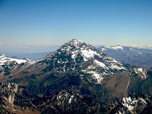 Aconcagua, January 2005 |
|
|
Aconcagua
|
|
| Elevation | 6,962 metres (22,841 ft) |
| Location | |
| Range | Andes |
| Prominence | 6,962 m (22,841 ft) Ranked 2nd |
| Coordinates | |
| First ascent | 1897 Matthias Zurbriggen (first recorded ascent)[1] |
| Easiest route | scramble (North) |
| Listing | Seven Summits Country high point Ultra |
Cerro Aconcagua is the highest mountain in America, and the highest mountain outside Asia. It is located in the Andes mountain range, in the Argentine province of Mendoza. The summit is located about 5 kilometres from San Juan Province and 15 kilometres from the international border with Chile. It lies 112 km (70 mi) west by north of the city of Mendoza. Aconcagua is the highest peak in both the Western and Southern Hemispheres. It is one of the Seven Summits.
Aconcagua is bounded by the Valle de las Vacas to the north and east and the Valle de los Horcones Inferior to the West and South. The mountain and its surroundings are part of the Aconcagua Provincial Park. The mountain has a number of glaciers. The largest glacier is the Ventisquero Horcones Inferior at about 10km long which descends from the south face to about 3600m altitude near the Confluencia camp[2]. Two other large glacier systems are the Ventisquero de las Vacas Sur and Glaciar Este/Ventisquero Relinchos system at about 5km long. However the most well-known is the north-eastern or Polish Glacier, a common route of ascent.
The mountain was created by the subduction of the Nazca Plate beneath the South American plate during the geologically recent Andean orogeny; however, it is not a volcano.[3] The origin of the name is contested, it is either from the Arauca Aconca-Hue, which refers to the Aconcagua River and means 'comes from the other side' or the Quechua Ackon Cahuak, meaning 'Sentinel of Stone'.
Contents |
Climbing
In mountaineering terms, Aconcagua is technically an easy mountain if approached from the north, via the normal route. Although the effects of altitude are severe (atmospheric pressure is 40% of sea-level at the summit), the use of supplemental oxygen is not required. Altitude sickness will affect most climbers to some extent, depending on the degree of acclimatization.
The second most frequented route is the Polish Glacier Traverse route, also known as the "Falso de los Polacos" route. This approaches the mountain through the Vacas valley, ascends to the base of the Polish Glacier, then traverses across to the normal route for the final ascent to the summit. The third most popular route is the Polish Glacier itself.
The routes to the peak from the south and south-west ridges are more demanding and the south face climb is considered very difficult.
Before attempting the mountain climbers need to purchase a permit from the Aconcagua Provincial Park authority in Mendoza. Prices vary depending on the season.

The camp sites on the normal route are listed below (altitudes are approximate).
- Puente del Inca, 2,740m (8,990ft): A small village on the main road, with facilities including a lodge.
- Confluencia, 3,380m (11,090ft): A camp site a few hours into the national park.
- Plaza de Mulas, 4,370m (14,340ft): Base camp, claimed to be the second largest in the world (after Everest). There are several meal tents, showers and internet access. There is a lodge 500 metres from the main campsite.
- Plaza Canadá, 5,050 metres (16,570 ft): A large ledge overlooking Plaza de Mulas.
- Plaza Alaska, 5,200 metres (17,060 ft): Called 'change of slope' in Spanish, a small site as the slope from Plaza de Mulas to Nido de Cóndores lessens. Not commonly used.
- Nido de Cóndores, 5,400 metres (17,720 ft): A large plateau with beautiful views. There is usually a park ranger camped here.
- Berlín, 5,900m (19,360ft): The usual high camp. Windy and exposed, and quite filthy. Many climbers avoid it, and stay slightly higher at Piedras Blancas.
It is common to spend at least one night in Confluencia while trekking to base camp in order to acclimatise properly. Summit attempts are usually made from a high camp at either Nido de Cóndores or Berlín. Although Berlín is closer to the summit, many climbers find that they rest better at Nido and are able to make up for the lost time. Some well-acclimatised climbers also pitch their high camp even further up the mountain, at Piedras Blancas (~6,000m) or near Independencia (~6350m). Practical hints and descriptions about different routes to the summit can be found on the Aconcagua mountaineering map, published 2006 by climbing map.[4]
History
The first attempt on Aconcagua by a European was made in 1883 by a party led by the German geologist and explorer Paul Güssfeldt. Bribing porters with the story that there was treasure on the mountain, he approached the mountain via the Rio Volcan, making two attempts on the peak by the north-west ridge and reaching an altitude of 6,500 metres (21,300 ft). The route that he prospected is now the normal route up the mountain.
The first recorded[1] ascent was in 1897 on a British expedition led by Edward Fitzgerald. The summit was reached by the Swiss guide Matthias Zurbriggen on January 14 and by two other expedition members a few days later.
The youngest person to reach the summit of Aconcagua was Jordan Romero of Big Bear Lake, California. He was 11 years old when he reached the summit on December 30, 2007.[5]
Popular culture
The mountain has a cameo in a 1942 Disney cartoon called Pedro.[6] The cartoon stars an anthropomorphic small airplane named Pedro who is compelled to make an air mail run over the Andes and has a near-disastrous encounter with Aconcagua. The mountain (also anthropomorphic, and scary-looking), later appeared in an illustration used in a retelling of the story in a Disney anthology book.
Gallery
See also
- Mendoza Province
- Las Heras, Mendoza
- Polish Glacier
Notes
- ↑ 1.0 1.1 The possibility of a previous ascent, even a precolumbian ascent, cannot be discounted, although no definitive evidence of such an ascent exists. Animal remains have been found high on the mountain, and peaks almost as high as Aconcagua, such as Llullaillaco, were ascended for ceremonial purposes in Inca times.
- ↑ Servei General d'Informacio de Muntanya, 2002, "Aconcagua 1:50,000 map", published by Cordee
- ↑ Simkin, T. and Siebert, L. (2002-). What is the world's highest volcano? Smithsonian Institution, Global Volcanism Program. Accessed 28 November 2007.
- ↑ Aconcagua climbing map A useful and accurate Swiss map with the most common mountaineering routes on Aconcagua, GPS compatible
- ↑ Website of sponsor
- ↑ IMDb page: Pedro
External links
- Aconcagua on summitpost.org
- Daily time lapse animations of the Aconcagua base camp Webcam
- Highest peaks on peakware.com
- (Spanish) Cordillera de los Andes
- Aconcagua info at andes.org.uk
Further reading
- Aconcagua, Jim Ryan. Cicerone 2004 ISBN 978 1 85284 455 4
|
|||||