Abra (province)
| Province of Abra | |
Provincial seal of Abra |
|
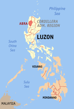 Map of the Philippines with Abra highlighted |
|
| Region | Cordillera Administrative Region (CAR) |
| Capital | Bangued |
| Divisions | |
| - Highly urbanized cities | 0 |
| - Component cities | 0 |
| - Municipalities | 27 |
| - Barangays | 303 |
| - Congressional districts | Lone District of Abra |
| Population | 12th smallest |
| - Total (2007) | 209,491 |
| - Density | 53 /km² (137 /sq mi) (4th lowest) |
| Area | 31st largest |
| - Total | 3,975.6 km2 (1,535 sq mi) |
| Founded | March 9, 1917 |
| Spoken languages | Ilokano, Tingguian/Itneg |
| Governor | Eustaquio P. Bersamin (PDSP) |
Abra is a landlocked province of the Philippines in the Cordillera Administrative Region in Luzon. Its capital is Bangued, and it borders Ilocos Norte and Apayao on the north, Ilocos Sur and Mountain Province on the south, Ilocos Norte and Ilocos Sur on the west, and Kalinga, and Apayao on the east.
Contents |
Demographics
Abra's inhabitants are mostly descendants of Ilocano settlers and members of the Tingguian tribe. As of 2005, the population of the province is 211,095.
The predominant languages are Ilocano[1] and Itneg[2]. Based on the 1995 census survey, Ilocano is generally spoken by 73.65% of the region's total population. 25.18% speak Itneg, 0.16% speak Tagalog, and the remaining 0.54% speak other dialects.
Economy
As of 1990, there were 743 cottage industries in Abra, of which 208 are registered with the Department of Trade and Industry. 59% are engaged in bamboo and rattan craft making, both leading industries in the area.
In 1992, the natural dye industry, together with loom weaving and embroidery, was revived by former Governor Ma. Zita Claustro-Valera, the first woman governor of Abra.
Abra's economy is agriculture-based. Its major crops are rice, corn, and root crops; and commercial produce are coffee, tobacco, and coconut. Extensive grassland and pasture areas are used for livestock production.
Geography
Political
Abra is subdivided into 27 municipalities.
| City/Municipality | No. of Barangays |
Area (km²) |
Population (2000) |
Pop. density (per km²) |
|
|---|---|---|---|---|---|
| Bangued | |||||
| Boliney | |||||
| Bucay | |||||
| Bucloc | |||||
| Luba | |||||
| Malibcong | |||||
| Manabo | |||||
| Peñarrubia | |||||
| Pidigan | |||||
| Pilar | |||||
| Sallapadan | |||||
Physical
Abra is hemmed in by the towering mountain ranges of the Ilocos in the west and the Cordillera Central in the east. It has an extremely rugged terrain, with mountains and hills rising along its perimeter and interior. The plains are drained by the Abra River, which flows northward from Mt. Data in the Mountain Province.
History
The first inhabitants of Abra were the ancestors of the Bontocs and the Ifugaos. These inhabitants eventually left to settle in the old Mountain Province. Other early inhabitants were the Tingguians, or Itnegs, as they are also known.
In 1598 a Spanish garrison was established in Bangued to protect the Ilocanos who converted to Christianity from Tingguian raids. During the British invasion of the Philippines, Gabriela Silang and her army fled to Abra from Ilocos and continued the revolt begun by her slain husband, Diego Silang. She was captured and hung by the Spanish in 1763.
In 1818 the Ilocos region, including Abra, was divided into Ilocos Norte and Ilocos Sur. In 1846 Abra was created[3] as a political-military province with Lepanto as a sub-province. It remained so until the arrival of the Americans in 1899.
In 1908 the Philippine Commission once again in annexed Abra to Ilocos Sur in an attempt to resolve Abra's financial difficulties. But on March 9, 1917, the Philippine Assembly reestablished Abra as a province.
In 1942, the Japanese forces was occupied to entered in Abra
| Battle of Abra | |||||||
|---|---|---|---|---|---|---|---|
| Part of World War II | |||||||
|
|||||||
| Belligerents | |||||||
In 1945, the liberation in Abra in Northern Luzon from defenders by the Allied Philippine Commonwealth forces and the local Cordilleran guerrillas against the Japanese during the Battle of Abra at the end the Second World War.
The revolutionary priest, Father Conrado Balweg, who fought for the rights of the Cordillera tribes, began his crusade in Abra. After successfully negotiating a peace accord with Balweg's group in 1987, the Philippine government created the Cordillera Administrative Region, which includes Abra.
Notes
- ↑ Dalby, Andrew (2004-02-18). Dictionary of Languages: The Definitive Reference to More Than 400 Languages. Columbia University Press. pp. p264. ISBN 978-0231115698. http://books.google.com/books?id=CnckpL8auSIC&pg=PA264&dq=Abra+Philippines&lr=&num=100&as_brr=3&ei=MlNQSMOyDKPujAGtjsFD&sig=nfubD1ejngacEsJ_VTQIMLGZgQc.
- ↑ Tryon, Darrell T. (1994). Comparative Austronesian Dictionary: An Introduction to Austronesian Studies. Ratzlow-Druck. pp. p171. ISBN 3110127296. http://books.google.com/books?id=U5EbSnWd-18C&pg=PA171&dq=Abra+Philippines&lr=&num=100&as_brr=3&ei=I09QSPOtEYLGjgG31oRB&sig=r6ZdRsMs6HGe5H3DdvpHqgMGaIs.
- ↑ Fernández, Leandro Heriberto. A Brief History of the Philippines. Ginn. pp. p195. http://books.google.com/books?id=1MRFAAAAIAAJ&pg=PA194&dq=Abra+Philippines&lr=&num=100&as_brr=3&ei=MlNQSMOyDKPujAGtjsFD#PPA195,M1.
External links
- The Official Website of the Provincial Government of Abra
- The Website of the Province of Abra
- WOW Philippines - Abra
- Tingguian.com - Featuring Tingguian Cultures, Traditions and Beliefs
- Abrenian.com - Online Community for Abrenians
- karitoon.com - Northern Luzon Online Community
- - Arya Abra
- History articles and links on Bucay and Abra
- karitoon.com - Northern Luzon Online Community
|
|||||