1960 Valdivia earthquake
 |
|
| Date | May 22, 1960 |
|---|---|
| Magnitude | 9.5 Mw[1] |
| Depth: | 33 km |
| Epicenter location: | Valdivia |
| Countries/ regions affected |
Chile |
| Casualties: | 2231, 3000, 5700[2] or 6000[3] |
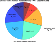
The 1960 Valdivia earthquake or Great Chilean Earthquake (Spanish: Gran terremoto de Valdivia) of 22 May, 1960 is to date the most powerful earthquake ever recorded, rating 9.5 [1] on the moment magnitude scale. It occurred in the afternoon (19:11 GMT, 2:11 PM local time) and its resulting tsunami affected southern Chile, Hawaii, Japan, the Philippines, eastern New Zealand, south east Australia and the Aleutian Islands in Alaska.
The epicenter was near Cañete (see map) some 700 km (435 miles) south of Santiago although Valdivia, Chile was the most affected city. It caused localised tsunamis that severely battered the Chilean coast, with waves up to 25 metres (82 feet). The main tsunami raced across the Pacific Ocean and devastated Hilo, Hawaii. Waves as high as 10.7 metres (35 feet) were recorded 10,000 kilometres (6,000 miles) from the epicentre, and as far away as Japan and the Philippines. The death toll and monetary losses arising from such a widespread disaster can never be precisely known. Various estimates of the total number of fatalities from the earthquake and tsunamis have been published, with the USGS citing studies with figures of 2231, 3000, or 5700 killed,[2] and another source uses an estimate of 6000 dead.[3] Different sources have estimated the monetary cost ranged from 400 million to 800 million US dollars[2] (or 2.8 to 5.5 billion in 2007 dollars, adjusted for inflation.)
Contents |
The earthquake in Chile


The Great Chilean Earthquake came after a smaller earthquake in Arauco Province at 06:02 on 21 May 1960. Telecommunications to southern Chile were cut off and President Jorge Alessandri had to cancel the traditional ceremony of the Battle of Iquique memorial holiday to oversee the emergency assistance efforts. The government was just beginning to organize help to the affected region when the second earthquake occurred at 14:55 UTC on 22 May in Valdivia.
The second earthquake affected all of Chile between Talca and Chiloé Island, more than 400,000 square kilometers (154,440.9 square miles). Coastal villages, such as Toltén, disappeared. Later studies argued that the earthquake actually had 37 epicenters through a 1,350 km (839 mi) north-south line that lasted from May 22 to June 6.[4] At Corral, the main port of Valdivia, the water level rose 4 m (13 ft) before it began to recede. At 16:20 UTC, an 8 m (26 ft) wave struck the Chilean coast, mainly between Concepción and Chiloe. Ten minutes later, another wave measuring 10 m (33 ft) was reported.
Hundreds of people were already reported dead by the time the tsunami struck. One ship, the El Canelo, starting at the mouth of Valdivia River sank after being moved 1.5 km (1 mi) backward and forward in the river. The mast of the Canelo is still visible from the road to Niebla.[4]
A number of inadequately engineered Spanish-colonial forts around Valdivia were completely destroyed. Soil subsidence also destroyed buildings, deepened local rivers, and created wetlands in places like the Río Cruces and Chorocomayo, a new aquatic park north of the city. Extensive areas of the city were flooded. The electricity and water systems of Valdivia were totally destroyed. Witnesses reported underground water flowing up through the soil. Despite the heavy rains of 21 May, the city was without a water supply. The river turned brown with sediment from landslides and was full of floating debris, including entire houses. The lack of potable water became a serious problem in one of Chile's most rainy regions.
Two days after the earthquake, Cordón Caulle of Puyehue volcano erupted. It is possible that other volcanoes also erupted, but none were recorded due to the lack of communication in Chile at that time. The relatively low death toll in Chile (estimated at 6,000) is explained, in part by the low population density and the fact that this region is a very active geological zone and builders know they have to build stronger structures. Other possible reasons include high number of wooden houses and that coastal towns also tended to be located on higher ground, following a pre-Hispanic tradition.
The Riñihuazo
- Main article: Riñihuazo.
During the Great Chilean Earthquake, several landslides west of Tralcan Mountain blocked the outflow of Riñihue Lake (). Riñihue Lake is the lowest of the Seven Lakes chain and receives a constant inflow from the Enco River. The blocked San Pedro River, which drains the lake, passes through several towns and the city of Valdivia before finally reaching Corral Bay.
Because the San Pedro River was blocked, the water level of Riñihue Lake started to rise quickly. Each meter the water level rose was equivalent to 20 million cubic meters, which meant that 4800 million cubic meters of water would release into the San Pedro River (easily overpowering its flow capacity of 400 cubic meters (14,126 cubic feet)) if it rose above the final, 24-meter-high dam. This potential disaster would have violently flooded all the settlements along the course of the river in less than five hours, and had more dire consequences if the dam suddenly broke.
About 100,000 people lived in the affected zone. Plans were made to evacuate Valdivia, and many people left. To avoid the destruction of the city, several military units and hundreds of workers from ENDESA, CORFO, and MOP started an effort, called the Riñihuazo, to control the lake. Twenty-seven bulldozers were put into service, but they had severe difficulties moving in the mud near the dams, so dykes had to be constructed with shovels. The work was not restricted to the lake; drainages from other parts of the Seven Lakes were also dammed to minimize the flow into Riñihue Lake. These dams were removed later, with the exception of Calafquén Lake, which still retains its dam.
By 23 May, the main dam had been lowered from 24 m (79 ft) to 15 m (49 ft), allowing 3000 million cubic meters of water to leave the lake gradually, but still with considerable destructive power. The team was led by military engineer Raúl Sáez
Human sacrifice
A book by investigative journalist Patrick Tierney, The Highest Altar: Unveiling the Mystery of Human Sacrifice (1989) ISBN 9780140139747 , documents a possible modern ritual human sacrifice during the devastating earthquake and tsunami of 1960 by a machi of the Mapuche in the Lago Budi community. The victim, 5 year old José Luis Painecur, had his arms and legs removed by Juan Pañán and Juan José Painecur (the victim's grandfather), and was stuck into the sand of the beach like a stake. The waters of the Pacific Ocean then carried the body out to sea. The sacrifice was rumored to be at the behest of local machi, Juana Namuncurá Añen. The 2 men were charged with the crime and confessed, but later recanted. They were released after 2 years. A judge ruled that those involved had "acted without free will, driven by an irresistible natural force of ancestral tradition." The story was mentioned in a Time Magazine article, although with little detail.[5]
Previous earthquakes
There is evidence that a similar landslide and earthquake occurred in 1575. [6]
See also
- List of earthquakes in Chile
References
- ↑ 1.0 1.1 U.S. Geological Survey (March 7, 2006). Historic Earthquakes - Chile - 1960 May 22 19:11:14 GMT- Magnitude 9.5: The Largest Earthquake in the World. Retrieved on 2007-01-09
- ↑ 2.0 2.1 2.2 "The Largest Earthquake in the World - Articles". U.S. Geological Survey. Retrieved on 2007-01-11.
- ↑ 3.0 3.1 "Emergency & Disasters Data Base". Centre for Research on the Epidemiology of Disasters (CRED). Retrieved on 2007-01-09.
- ↑ 4.0 4.1 La Tercera Retrieved on 2008-01-14
- ↑ http://www.time.com/time/magazine/article/0,9171,869529,00.html
- ↑ Breve Historia de Valdivia. Editorial Francisco de Aguirre. 1971. http://www.buscalibros.cl/libros.php?c=226.