Image:WestBengalDistrictscurrent.png
From Wikipedia, the free encyclopedia
No higher resolution available.
WestBengalDistrictscurrent.png (450 × 500 pixels, file size: 69 KB, MIME type: image/png)
| | This is a file from the Wikimedia Commons. The description on its description page there is shown below.
|
[edit] Summary
| Description |
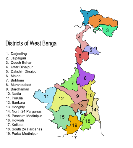
Original summary by creator of base svg file deeptrivia. Districts of West Bengal Based on http://web.archive.org/web/20040606103522/www.censusindia.net/results/2001maps/wbengal01.html Exported from the modified svg file to png. Original modifications can be found here [1], since it was not formatted properly after modifications. Modifications by User:Antorjal:
|
|---|---|
| Source |
http://en.wikipedia.org/wiki/Image:WestBengalDistrictscurrent.png#file |
| Date | |
| Author |
|
| Permission (Reusing this image) |
see below |
[edit] Licensing

File history
Click on a date/time to view the file as it appeared at that time.
| Date/Time | Dimensions | User | Comment | |
|---|---|---|---|---|
| current | 13:17, 13 November 2006 | 450×500 (69 KB) | Dwaipayanc | ({{Information |Description=Original summary by creator of base svg file [http://en.wikipedia.org/wiki/User:Deeptrivia deeptrivia]. Districts of West Bengal Based on http://web.archive.org/web/20040606103522/www.censusindia.net/results/2001maps/wbengal01.h) |
File links
- Portal:West Bengal/Selected articles
- Portal:West Bengal/Did you know
- Portal:West Bengal/Selected article candidates
- Template:PWBSAC-instructions
- Portal:West Bengal/What is a selected article
- Portal:West Bengal/Selected article removal candidates
- Portal:West Bengal/Selected pictures
- Portal:West Bengal/What is a selected picture
- Portal:West Bengal/Selected picture candidates
- Portal talk:West Bengal
- Portal:West Bengal/News
- Portal:West Bengal/News/Archive
- Portal:West Bengal/Selected biography
- Portal:West Bengal/Selected article candidates/Archived nominations
- Portal:West Bengal/Selected articles/Layout
- Portal:West Bengal/Selected biography/Layout
- Portal:West Bengal/Selected pictures/Layout
- Portal:West Bengal/Selected articles/Usage
- Portal:West Bengal/Selected picture candidates/Archived nominations
- Portal:West Bengal/Navigation
- Portal:West Bengal/News/Archive/1


![[1]](http://en.wikipedia.org/wiki/Image:WestBengalDistricts_numbered.svg)