Image:US state abbrev map.png

From Wikipedia, the free encyclopedia

Wikimedia Commons logo This is a file from the Wikimedia Commons. The description on its description page there is shown below.
Commons is a freely licensed media file repository. You can help.

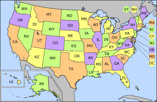
A colored map showing the United States with state abbreviations. Outline map is public-domain, and is used courtesy of The General Libraries, The University of Texas at Austin. The map has been heavily modified, with color and labelling added by Wapcaplet in the GIMP.

Originally uploaded to English Wikipedia by Wapcaplet (02:49, 11 Jul 2003)


GNU head Permission is granted to copy, distribute and/or modify this document under the terms of the GNU Free Documentation license, Version 1.2 or any later version published by the Free Software Foundation; with no Invariant Sections, no Front-Cover Texts, and no Back-Cover Texts. A copy of the license is included in the section entitled "GNU Free Documentation license".

Aragonés | العربية | Asturianu | Български | বাংলা | ইমার ঠার/বিষ্ণুপ্রিয়া মণিপুরী | Brezhoneg | Bosanski | Català | Cebuano | Česky | Dansk | Deutsch | Ελληνικά | English | Esperanto | Español | Eesti | Euskara | فارسی | Suomi | Français | Gaeilge | Galego | עברית | Hrvatski | Magyar | Bahasa Indonesia | Ido | Íslenska | Italiano | 日本語 | ქართული | ភាសាខ្មែរ | 한국어 | Kurdî / كوردی | Latina | Lëtzebuergesch | Lietuvių | Bahasa Melayu | Nnapulitano | Nederlands | ‪Norsk (nynorsk)‬ | ‪Norsk (bokmål)‬ | Occitan | Polski | Português | Română | Русский | Slovenčina | Slovenščina | Shqip | Српски / Srpski | Svenska | తెలుగు | ไทย | Türkçe | Українська | اردو | Tiếng Việt | Volapük | Yorùbá | ‪中文(中国大陆)‬ | ‪中文(台灣)‬ | +/-

Note, if you want it, for use on Wikimedia versions that support it (1.10 and above), this page includes a copy of a matching clickmap for the 50 states and DC which may be used as is or modified for various purposes as needed, and this clickmap is included below this text in the source of this page. Use the edit this page button, and take everything from <imagemap> through </imagemap> and if you need it, you can change the state links if needed (for example, if you were doing List of counties in Arizona, you'd want to change the Arizona link to have "list of counties" precede it inside the link text.

Washington Oregon California Hawaii Alaska Idaho Vermont New Hampshire Massachusetts Rhode Island Connecticut New Jersey Delaware Maryland District of Columbia Montana North Dakota South Dakota Nevada Utah Arizona Wyoming Colorado New Mexico Nebraska Kansas Oklahoma Texas Minnesota Iowa Missouri Arkansas Louisiana Michigan Wisconsin Illinois Indiana Ohio West Virginia Kentucky Tennessee Mississippi Alabama Georgia Florida South Carolina North Carolina Virginia Maryland Maryland District of Columbia Delaware New York Pennsylvania New Jersey Connecticut Rhode Island Massachusetts New Hampshire Vermont Maine

About this image

File history

Click on a date/time to view the file as it appeared at that time.

Date/TimeDimensionsUserComment
current03:24, 5 May 2005501×327 (32 KB)Mattes (new)